
Kamiloiki Ridge Trail Photos


You might also consider


More like Kamiloiki Ridge Trail
Recommended Reviews - Kamiloiki Ridge Trail
Start your review...


Reviews With Photos
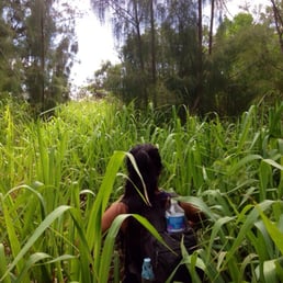

"Let's-go-on-a-hiiiiiike" (FB Message) "Take-me-on-a-hike-with-youuuuuu" (Text Message) "Hikehikehikehikehikehikehiiiiiiiiiiike" You're Cool (Yelp Compliment) "Lets-go-on-an-adventurrrrrrrrrre.. Did you get my other messages??" (Email) * * * Got a friend who isn't a hiker, desperately trying to hike with you? Take them to Kamiloiki. It will either scare them off and they'll never bother you again. Or you can see how they handle an easy trail with tough conditions. It's an underwhelming, pain-in-the-ass, itchy & scratchy, hike. (heh-heh) That is, until you come upon that final rise, and it opens up to one of the most spectacular views of the Windward side I have ever seen. It literally took my breath away. Hike Time: about 3-4hrs+ roundtrip Most of this hike is shadeless. If you go in the middle of a nice day, it will be brutally hot. It took me and my gf about 5hrs! However, that includes about an hour of chill/shooting time at the end, and lots of small water breaks. AND about 20 minutes of us getting lost on our way back down. Difficulty level: Beginner Challenging The hike itself is mostly a gradual slope, and not very challenging. The hard part for me was dealing with the heat. I drank about 2L of water. Bring more than you think you'll need. Somethings you'll deal with on this trail: Low Lying shrubs These little bastards will leave you scraped up and possibly bleeding (I was!) Consider wearing pants. Tall Grass (head high) Starting about halfway up the trail, you'll begin to encounter LOTS of this stuff (see pics). I was hiking without a shirt because of the heat, my arms, and stomach were itching/burning like crazy!! So I gave in and put the shirt back on. Next time I might pack a long sleeve just to wear during these parts. Crumbly rocks These old ridges.. are old. Not only do you have to watch your step for loose rocks, but for roots sticking out. I have good boots, so I didn't slip during this hike, but I did trip on a few roots. Finding the trail head Follow the Yelp map/directions, and park on the street. As always, be respectful of residence. Leave no trash, be quiet. Locate the Heiau at the end of the cul-de-sac, you'll see a "Kapu" sign. Take the stairs up, on the right side of the Heiau, and once above it, walk to the left behind/around it. You'll come to some tall grass and see a faint trail and hopefully a ribbon. As you continue on, follow the ribbons until the trail becomes obvious. When coming back down from the hike, BE CAREFUL to follow the ribbons. It does get confusing. It's not the longest hike, but unless you're running out of water or daylight - keep going! This hike really is all about the view.


I haven't been hiking in about a month and a half so I was stoked to get out in the mountains again. Kamioiki had been on my list for a while and I was excited to do my 20th hike! Unfortunately this means 30 more, by December 2012. AHHH I love going on hikes that 1. I haven't done 2. have rewarding views 3. are not crowded and this hike definitely hit all three points. The first 3/4 of it is pretty barren, with NO shade. Lucky for us it was windy so we didn't get as hot as I'm sure others do on sunny/non-windy days. I didn't find it to be too difficult, a little bit of rock climbing but nothing that can't be done by a beginner hiker. The hardest part is near the end where there are little inclines you have to climb up, but seriously nothing too hard that will get your buns burning. It is mostly shaded in the trees so its not only a nice change of scenery but much cooler. Plus your walking on pine needles making the ground soft and easy to walk on. The view is of course unreal. You get a beautiful view of Waimanalo, Olomana, and almost to Kaneohe. The water was so crystal blue it made me want to just jump into the ocean....If only we could fly. You go down the same way you go up so get ready to walk along those barren rocks again. It took us about 2 hours so a perfect morning or mid-afternoon hike. I would rate it as a beginner-intermediate hike. YELP 365: 200/365
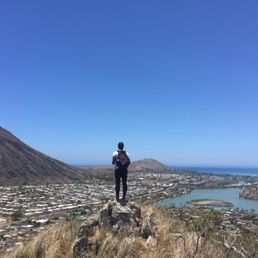

Loved this hike besides the start when I carefully entered around the heiau. Always wonder if there's a different entrance besides that due to walking near sacred ground...but anyway, best views on this hike! Although it was intensely hot when I went and there was no breeze until we got to the leeward side. It can be a bit extensive depending on how far you want to go. Pack a hat, sunblock, lunch, and lots of water Definitely top 3 of my favorite hikes on the island (& I've done quite a few).


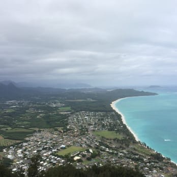
This is a great hike with rewarding view towards the end! It took us 3 hours and only encountered 1 couple on our way down. The beginning was gradual incline, going up and down up and down the ridge line several times, then you'll be in the trees and eventually rewarded with beautiful view of Waimanalo. I've read a few reviews about the grass and bushes. We went today (11/28/14) and as of now the grass has grown head height to almost the entire hike. The trail would've been rated easy if it wasn't for the overgrown grass and branches completely blocking your sight and the trail! Please be careful as there are rocks, drop offs that are camouflaged! Wear long pants if u can take the heat, my legs were pretty scraped up by the branches.


Not a maintained hike. Overgrown bushes and trees. Sacred area at the base of the hike. No Trespassing signs posted. A friendly resident saw us trying to find the start and he told us the hike started on the left. We attempted to push our way through bushes for a few minutes and shortly gave up after getting multiple bug bites and scratches from the poorly maintained trail. It looks like nobody has hiked it in a very long time. Bring a machete with you if you plan to do this hike.


This trail can be very hot. Do you want to start as early as you can in the morning. About 1.5 hours to reach to the spectacular view at the end. And about 1 hour to come back as it's downhill. You get great view, so please add 20-30 minutes to stay at the end to enjoy it. Please make sure you bring enough water. I usually take 1.5-2L of water for this hike. Not suitable for kids or dog. I would say this is intermediate level. You go though some overgrown bushes, so long pants are recommended unless you don't mind getting scratches.


I've done this hike a few times and each time has been a different, amazing experience! I like to challenge myself and do 'cardio' hiking like my friend Kyle H. I'm nowhere near as fast as her, but I definitely get a good heart pumping workout and have become a pretty descent trail blazer. This hike took my friends and I about 3 hours round trip with a few breaks. This time around, the trail was majorly overgrown. I'm thankful for the rain that makes everything green and even more thankful for the long pants I wore! Even with the overgrown wilderness, the trail was still visible and relatively easy to follow, taking us up and down, onto ridges and through a pine forest. About an hour and a half in, you reach a clearing in the trees; a breathtaking view of Waimanalo. Mountains, beach, ocean, gorgeous! The trail continues on further, but most people turn around at this point and retrace their steps back to the beginning. This is as far as I went this time. Parking is on the street in the neighborhood. The trailhead is easy to spot and starts at the heeiau. Please be respectful and walk around this ancient site.


1 of 6 hikes I frequent in the Hawaii Kai area. Kamiloiki Ridge is one of those secret gems of Oahu that few know about and fewer take advantage of. If you are into going Medieval and being one with nature and the Earth tantric spirit of Gaia and all that crap, this is the perfect hike to spend some quiet one-on-one time with your invisible best friend and imaginary girlfriend. Hmmmmmm... can you even have one-on-one time with your imaginary girlfriend if you have an invisible friend? Wow I don't know where that one came from... one day my account is going to get flagged for inappropriate content. Can it get flagged? If you know, tell me so I can make a dummy account. If it's you Lori I. send it via compliments instead of the inbox. Since I am a keyjogger wussy and I like it better when you pump up my ego publicly. But if it's you Kyle H. just facebook me... you embarrass the Hello Kitty inner child in me on Yelp. But really it's a great awesome hike! And without the hassle of crowds.... I've had reservations about writing a review for this hike because I like having secret spots but maybe if more people go, that's less overgrown grass I have to pull out of my ass after the hike. I say this with conviction, I'll give you a quarter, A QUARTER for every person you run into here. And when Dec 21 2012 rolls around and the world comes crashing to a Mayan New-Age Elvis Presley end, we can tally up your head count and maybe you'll have enough to buy an extra margarita and finally have enough liquid courage to say something stupid to that hottie you'd never normally have the balls to talk to so then I won't have to come on here and read a review about you having a bitch-fit because the bartender didn't make it strong enough for you.... Arrrhhhh ok where was I??? Oh yes, a hike... I'd give this one a medium hard difficult rating. The first 5-10 minutes are steep uphill to get onto the ridge but you are quickly rewarded with a great view of Hawaii Kai. If you are a little keyjogger wussy that sits around and clicks the refresh button to see if anyone found your review useful, you can snap that photo and head back down. But for the rest of you, it's about 2 mile more hike along an up and down ridge. I've read it's 6 total, 3 miles each way but I was just there with my friend Dave(he's the little bald out of place looking Haole in the picture) last week and his GPS read only 4 miles, 2 each way. Bring water, lots since there is little shade similar to Koko Crater, same area so same sun intensity. Only 5/6 the way in do you come to an area of trees that provide shade cover. Lots of wind though, helps keep you cool but might affect balance so be careful if you bring someone you like and trying to impress. I've heard there are goats on the trail but have never seen any. At the end you'll come to a cross road that's splits left or right. Here is the view that you are generously rewarded with it, and what a view it is. You feel like just losing yourself and jumping over to fly down, it's that panoramic. But if you continue on a bit going right for another 10 minutes you'll be surprised with a second lookout view that let's you see rabbit island in all it's glory, a view second only to the one you get on the Tom Tom trail... and actually this connects with that trail but that's a longer, more difficult hike for more advanced hikers. And in closing(in public speaking that means I'm going to be in love with the sound of my own voice for another 10 minutes), directions! Driving on Lunalilo Home road until you come to Kamiloiki Park, which is on the right. Instead turn left on Hawaii Kai Drive into Mariner's Clove. Then on your first right turn onto Waioli Street and then your immediate left onto Makahuena Place. The entrances is in a Hawaiian Heiau marked by a large collected of stones, you really can't miss it(I see said the blind man to the deaf man), but if all else just follow the ridge. It's in a residental area so for parking you'll want to drive around and look for one of those brightly colored yellow metal posts that stick out of the side walk that firefighters use for access to emergency water.... park there!
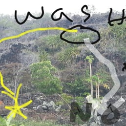

So on the way down i was in the zone and ended at the end of the trail where i can see my car but can't get down...surrounded by cactus i stood there for 5 min trying to figure out what the deal was.i back tracked to try and see if i can find the trail but no luck. So i went gorilla style. The End, FIN! P.S white line was my route. All in all i like this trail, and it is freshman friendly ,good view


Open ridge trail for about 3/4 of the trail. It's hot, dry and rocky...but a lot of fun. End of the trail opens up to gorgeous views. Hiked this trail twice and I think that's about it for me. Sunscreen, hat, at least 2 liters (that's my humble recommendation...I always bring 3L on trails over 2 miles). When I hiked this trail it was overgrown due the influx of rain we had for several months. This trail connects to other known ridge trails. When you get to the end, head upwards to move on. Enjoy.


Mother nature always gets 5 stars! Much more rugged trail compared to Kuliouou Ridge Trail. Very tall weeds/plants so leave your shirt on so you don't get all itchy. One of the best things about this hike if you can find it, is the seclusion. You will probably be the only person on the trail. Look for the pink ribbon trail markers. I believe you can access the trail from Makahuena Place. Great view of Waimanalo and surrounding beaches.


Nice hike with pretty views of Hawaii Kai. Fun to do if you've already done the other Hawaii Kai ridge trails. However, if you haven't already done the other ridge trails in the area (Wiliwilinui, Hawaii Loa, Kuliouou, Mariner's), I would recommend those first because they have similar views with prettier flora and more shade, and they are less awkward to go to (this one has Kapu signs and a lot of people in the neighborhood kept eyeing us both when we were starting and ending our hike. And then a little girl started yelling at us to not be there when we were leaving).


Believe the reviews, this trail is overgrown...but don't let that stop you from going! It starts in a neighborhood in Hawaii Kai so be respectful of the residents and park a block or so away from the hike and walk down to the cul de sac. When you get to the Heiau there are no hiking signs, so this is your own choice to move on or not. If you decide to continue on, go to the left of the heiau and follow the overgrown path with pink and yellow ribbons. It's not difficult to find. Once you get up on top of the trail it's simple to follow. Be sure to wear a hat and/or sunscreen! It was really hot when we went and I had wished I wore a hat and pants. The trail took us through some cool terrain and was shady after the first half hour. It was windy at the top but totally worth it! It took me 1 hr and 20 min to get to the top and I stopped a few times to have water and take a breath. The views were spectacular. I can't wait to do this hike again. Total it took a little under 3 hours. I highly recommend it! read more


Very easy to get lost. Bushes were very high which can hide holes and rocks. Look for ribbons and use intuition to go up. Do not go into people's yards. Once you reach pine forest the summit is very near. But this is the trickiest part. Keep a sharp eye out for the ribbons. Just remember to keep going up not around the cliff. Views are awesome during and the end. read more


I loved the variety of terrain this hike provided as well as the awesome cardio all the way through! Our hike began by climbing over some lava rock at the back of a heiau, which was located very surprisingly close to the main road. http://www.yelp.com/biz_photos/kamiloiki-ridge-trail-honolulu?select=5gU05COGWZ6TCjdW3mG0ow#AVo6JYwUbWJ1Aaj_sdeqqQ From that point and for most of the next 30-40 minutes, depending on your pace, it's a zig-zag and mild uphill climb across rocks, mostly dry and well-trodden path (during this portion you can see into the valley and see the cookie-cutter neighborhood from above), and through a beautiful breezy pine forest to one of the first ridge viewpoints. http://www.yelp.com/biz_photos/kamiloiki-ridge-trail-honolulu?select=5gU05COGWZ6TCjdW3mG0ow#qlvAyJmpy9EG1NUToZMrbw When you get to this lookout, you are made of stone if your jaw doesn't drop at the pleasure of such a gorgeous view. http://www.yelp.com/biz_photos/kamiloiki-ridge-trail-honolulu?select=5gU05COGWZ6TCjdW3mG0ow#2GNcaYZkvHJqRoysM9MGBw There's more to come, a few minutes more up the ridge, you get one the best vantage points, you're able to see on both sides of the ridge, the ocean seemingly surrounding the one point where you stand! http://www.yelp.com/biz_photos/kamiloiki-ridge-trail-honolulu?select=5gU05COGWZ6TCjdW3mG0ow#wnTlyrr3Ls-hMOXUEfY0fQ Continuing on, there are a few steep areas to navigate down and up, it looks much more technical and scary than it really is. http://www.yelp.com/biz_photos/kamiloiki-ridge-trail-honolulu?select=5gU05COGWZ6TCjdW3mG0ow#go-Zr8Z8r14zpTwcn5AnlQ http://www.yelp.com/biz_photos/kamiloiki-ridge-trail-honolulu?select=5gU05COGWZ6TCjdW3mG0ow#V0FsXbFTfcVk8zJtuUSX4g After this point, you're pretty much home free and you've made it to the area accessible from the Makapu'u lookout point (where you can get to the hang-gliding jump points). This was definitely one of the most favorite hikes I've done. Gorgeous views and great workout! read more


"Let's-go-on-a-hiiiiiike" (FB Message) "Take-me-on-a-hike-with-youuuuuu" (Text Message) "Hikehikehikehikehikehikehiiiiiiiiiiike" You're Cool (Yelp Compliment) "Lets-go-on-an-adventurrrrrrrrrre.. Did you get my other messages??" (Email) * * * Got a friend who isn't a hiker, desperately trying to hike with you? Take them to Kamiloiki. It will either scare them off and they'll never bother you again. Or you can see how they handle an easy trail with tough conditions. It's an underwhelming, pain-in-the-ass, itchy & scratchy, hike. (heh-heh) That is, until you come upon that final rise, and it opens up to one of the most spectacular views of the Windward side I have ever seen. It literally took my breath away. Hike Time: about 3-4hrs+ roundtrip Most of this hike is shadeless. If you go in the middle of a nice day, it will be brutally hot. It took me and my gf about 5hrs! However, that includes about an hour of chill/shooting time at the end, and lots of small water breaks. AND about 20 minutes of us getting lost on our way back down. Difficulty level: Beginner Challenging The hike itself is mostly a gradual slope, and not very challenging. The hard part for me was dealing with the heat. I drank about 2L of water. Bring more than you think you'll need. Somethings you'll deal with on this trail: Low Lying shrubs These little bastards will leave you scraped up and possibly bleeding (I was!) Consider wearing pants. Tall Grass (head high) Starting about halfway up the trail, you'll begin to encounter LOTS of this stuff (see pics). I was hiking without a shirt because of the heat, my arms, and stomach were itching/burning like crazy!! So I gave in and put the shirt back on. Next time I might pack a long sleeve just to wear during these parts. Crumbly rocks These old ridges.. are old. Not only do you have to watch your step for loose rocks, but for roots sticking out. I have good boots, so I didn't slip during this hike, but I did trip on a few roots. Finding the trail head Follow the Yelp map/directions, and park on the street. As always, be respectful of residence. Leave no trash, be quiet. Locate the Heiau at the end of the cul-de-sac, you'll see a "Kapu" sign. Take the stairs up, on the right side of the Heiau, and once above it, walk to the left behind/around it. You'll come to some tall grass and see a faint trail and hopefully a ribbon. As you continue on, follow the ribbons until the trail becomes obvious. When coming back down from the hike, BE CAREFUL to follow the ribbons. It does get confusing. It's not the longest hike, but unless you're running out of water or daylight - keep going! This hike really is all about the view. read more
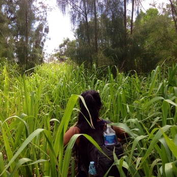

I haven't been hiking in about a month and a half so I was stoked to get out in the mountains again. Kamioiki had been on my list for a while and I was excited to do my 20th hike! Unfortunately this means 30 more, by December 2012. AHHH I love going on hikes that 1. I haven't done 2. have rewarding views 3. are not crowded and this hike definitely hit all three points. The first 3/4 of it is pretty barren, with NO shade. Lucky for us it was windy so we didn't get as hot as I'm sure others do on sunny/non-windy days. I didn't find it to be too difficult, a little bit of rock climbing but nothing that can't be done by a beginner hiker. The hardest part is near the end where there are little inclines you have to climb up, but seriously nothing too hard that will get your buns burning. It is mostly shaded in the trees so its not only a nice change of scenery but much cooler. Plus your walking on pine needles making the ground soft and easy to walk on. The view is of course unreal. You get a beautiful view of Waimanalo, Olomana, and almost to Kaneohe. The water was so crystal blue it made me want to just jump into the ocean....If only we could fly. You go down the same way you go up so get ready to walk along those barren rocks again. It took us about 2 hours so a perfect morning or mid-afternoon hike. I would rate it as a beginner-intermediate hike. YELP 365: 200/365 read more


10 years ago
Loved this hike besides the start when I carefully entered around the heiau. Always wonder if there's a different entrance besides that due to walking near sacred ground...but anyway, best views on this hike! Although it was intensely hot when I went and there was no breeze until we got to the leeward side. It can be a bit extensive depending on how far you want to go. Pack a hat, sunblock, lunch, and lots of water Definitely top 3 of my favorite hikes on the island (& I've done quite a few). read more


8 years ago


This is a great hike with rewarding view towards the end! It took us 3 hours and only encountered 1 couple on our way down. The beginning was gradual incline, going up and down up and down the ridge line several times, then you'll be in the trees and eventually rewarded with beautiful view of Waimanalo. I've read a few reviews about the grass and bushes. We went today (11/28/14) and as of now the grass has grown head height to almost the entire hike. The trail would've been rated easy if it wasn't for the overgrown grass and branches completely blocking your sight and the trail! Please be careful as there are rocks, drop offs that are camouflaged! Wear long pants if u can take the heat, my legs were pretty scraped up by the branches. read more



6 years ago

8 years ago
Not a maintained hike. Overgrown bushes and trees. Sacred area at the base of the hike. No Trespassing signs posted. A friendly resident saw us trying to find the start and he told us the hike started on the left. We attempted to push our way through bushes for a few minutes and shortly gave up after getting multiple bug bites and scratches from the poorly maintained trail. It looks like nobody has hiked it in a very long time. Bring a machete with you if you plan to do this hike. read more


12 years ago
This trail can be very hot. Do you want to start as early as you can in the morning. About 1.5 hours to reach to the spectacular view at the end. And about 1 hour to come back as it's downhill. You get great view, so please add 20-30 minutes to stay at the end to enjoy it. Please make sure you bring enough water. I usually take 1.5-2L of water for this hike. Not suitable for kids or dog. I would say this is intermediate level. You go though some overgrown bushes, so long pants are recommended unless you don't mind getting scratches. read more


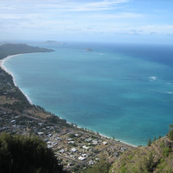
I've done this hike a few times and each time has been a different, amazing experience! I like to challenge myself and do 'cardio' hiking like my friend Kyle H. I'm nowhere near as fast as her, but I definitely get a good heart pumping workout and have become a pretty descent trail blazer. This hike took my friends and I about 3 hours round trip with a few breaks. This time around, the trail was majorly overgrown. I'm thankful for the rain that makes everything green and even more thankful for the long pants I wore! Even with the overgrown wilderness, the trail was still visible and relatively easy to follow, taking us up and down, onto ridges and through a pine forest. About an hour and a half in, you reach a clearing in the trees; a breathtaking view of Waimanalo. Mountains, beach, ocean, gorgeous! The trail continues on further, but most people turn around at this point and retrace their steps back to the beginning. This is as far as I went this time. Parking is on the street in the neighborhood. The trailhead is easy to spot and starts at the heeiau. Please be respectful and walk around this ancient site. read more


1 of 6 hikes I frequent in the Hawaii Kai area. Kamiloiki Ridge is one of those secret gems of Oahu that few know about and fewer take advantage of. If you are into going Medieval and being one with nature and the Earth tantric spirit of Gaia and all that crap, this is the perfect hike to spend some quiet one-on-one time with your invisible best friend and imaginary girlfriend. Hmmmmmm... can you even have one-on-one time with your imaginary girlfriend if you have an invisible friend? Wow I don't know where that one came from... one day my account is going to get flagged for inappropriate content. Can it get flagged? If you know, tell me so I can make a dummy account. If it's you Lori I. send it via compliments instead of the inbox. Since I am a keyjogger wussy and I like it better when you pump up my ego publicly. But if it's you Kyle H. just facebook me... you embarrass the Hello Kitty inner child in me on Yelp. But really it's a great awesome hike! And without the hassle of crowds.... I've had reservations about writing a review for this hike because I like having secret spots but maybe if more people go, that's less overgrown grass I have to pull out of my ass after the hike. I say this with conviction, I'll give you a quarter, A QUARTER for every person you run into here. And when Dec 21 2012 rolls around and the world comes crashing to a Mayan New-Age Elvis Presley end, we can tally up your head count and maybe you'll have enough to buy an extra margarita and finally have enough liquid courage to say something stupid to that hottie you'd never normally have the balls to talk to so then I won't have to come on here and read a review about you having a bitch-fit because the bartender didn't make it strong enough for you.... Arrrhhhh ok where was I??? Oh yes, a hike... I'd give this one a medium hard difficult rating. The first 5-10 minutes are steep uphill to get onto the ridge but you are quickly rewarded with a great view of Hawaii Kai. If you are a little keyjogger wussy that sits around and clicks the refresh button to see if anyone found your review useful, you can snap that photo and head back down. But for the rest of you, it's about 2 mile more hike along an up and down ridge. I've read it's 6 total, 3 miles each way but I was just there with my friend Dave(he's the little bald out of place looking Haole in the picture) last week and his GPS read only 4 miles, 2 each way. Bring water, lots since there is little shade similar to Koko Crater, same area so same sun intensity. Only 5/6 the way in do you come to an area of trees that provide shade cover. Lots of wind though, helps keep you cool but might affect balance so be careful if you bring someone you like and trying to impress. I've heard there are goats on the trail but have never seen any. At the end you'll come to a cross road that's splits left or right. Here is the view that you are generously rewarded with it, and what a view it is. You feel like just losing yourself and jumping over to fly down, it's that panoramic. But if you continue on a bit going right for another 10 minutes you'll be surprised with a second lookout view that let's you see rabbit island in all it's glory, a view second only to the one you get on the Tom Tom trail... and actually this connects with that trail but that's a longer, more difficult hike for more advanced hikers. And in closing(in public speaking that means I'm going to be in love with the sound of my own voice for another 10 minutes), directions! Driving on Lunalilo Home road until you come to Kamiloiki Park, which is on the right. Instead turn left on Hawaii Kai Drive into Mariner's Clove. Then on your first right turn onto Waioli Street and then your immediate left onto Makahuena Place. The entrances is in a Hawaiian Heiau marked by a large collected of stones, you really can't miss it(I see said the blind man to the deaf man), but if all else just follow the ridge. It's in a residental area so for parking you'll want to drive around and look for one of those brightly colored yellow metal posts that stick out of the side walk that firefighters use for access to emergency water.... park there! read more






13 years ago

14 years ago
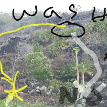
So on the way down i was in the zone and ended at the end of the trail where i can see my car but can't get down...surrounded by cactus i stood there for 5 min trying to figure out what the deal was.i back tracked to try and see if i can find the trail but no luck. So i went gorilla style. The End, FIN! P.S white line was my route. All in all i like this trail, and it is freshman friendly ,good view read more

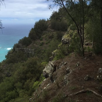
Open ridge trail for about 3/4 of the trail. It's hot, dry and rocky...but a lot of fun. End of the trail opens up to gorgeous views. Hiked this trail twice and I think that's about it for me. Sunscreen, hat, at least 2 liters (that's my humble recommendation...I always bring 3L on trails over 2 miles). When I hiked this trail it was overgrown due the influx of rain we had for several months. This trail connects to other known ridge trails. When you get to the end, head upwards to move on. Enjoy. read more



12 years ago
Mother nature always gets 5 stars! Much more rugged trail compared to Kuliouou Ridge Trail. Very tall weeds/plants so leave your shirt on so you don't get all itchy. One of the best things about this hike if you can find it, is the seclusion. You will probably be the only person on the trail. Look for the pink ribbon trail markers. I believe you can access the trail from Makahuena Place. Great view of Waimanalo and surrounding beaches. read more


11 years ago
Nice hike with pretty views of Hawaii Kai. Fun to do if you've already done the other Hawaii Kai ridge trails. However, if you haven't already done the other ridge trails in the area (Wiliwilinui, Hawaii Loa, Kuliouou, Mariner's), I would recommend those first because they have similar views with prettier flora and more shade, and they are less awkward to go to (this one has Kapu signs and a lot of people in the neighborhood kept eyeing us both when we were starting and ending our hike. And then a little girl started yelling at us to not be there when we were leaving). read more


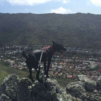


10 years ago

11 years ago
Pretty intense if you go when the sun is beaming down on you as there is very little shade if you go during noon hours. Plan ahead and bring sunscreen and water. Go slow if you need to and just keep pushing along. read more

8 years ago

10 years ago
Killer hike, not too hard, lots of vegetation though. If you're prone to getting scratched, long pants Just make sure you start off correctly, on the path to the right and stay on the path. read more

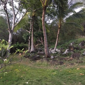


14 years ago
9 years ago
Do NOT climb on the ancient temple here. It is confusing but you start out to the left side of the Temple (past the first "Kapu" No Trespassing sign, walk 10 meters, then turn back right at the smaller "private property, no trespassing" sign. Hug the west face of the ridge after that, making your awkward ascent to the ridge line. Once you pop out on the ridge it's a straight shot to the summit with great views. Beware VERY little shade and gets hot after 10 a.m. in summer months. Brush does scratch the legs but nothing terrible IMO. Enjoyable hike overall but last 1/3 up is definitely the best part. read more
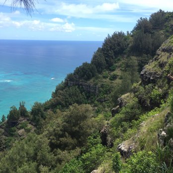

14 years ago
12 years ago

10 years ago
13 years ago

More info about Kamiloiki Ridge Trail
7788 Hawaii Kai Dr
Honolulu, HI 96825
Directions
(808) 397-5800
Call Now
Hours
Outdoor Amenities
Ask the Community - Kamiloiki Ridge Trail
Review Highlights - Kamiloiki Ridge Trail
You might also consider



















Why does Yelp recommend reviews?
1 review that is not currently recommended
The reviews below are not factored into the business's overall star rating.

10 years ago
Kamiloiki Ridge Trail - hiking - Updated September 2026
Best of Honolulu
People found Kamiloiki Ridge Trail by searching for…
Off Road Trails in Honolulu, HI
Walking Trails in Honolulu, HI
Dog Friendly Hiking Trails in Honolulu, HI
Water Parks for Kids in Honolulu, HI
Stroller Friendly Hikes in Honolulu, HI
Stairs Workout in Honolulu, HI
Stair Climbing in Honolulu, HI
Running Routes in Honolulu, HI
Running Trails in Honolulu, HI
Trending Searches in Honolulu, HI
Archery near Kamiloiki Ridge Trail
Barbershop For Men near Kamiloiki Ridge Trail
Bike Shop near Kamiloiki Ridge Trail
Bird Sanctuary near Kamiloiki Ridge Trail
Casinos near Kamiloiki Ridge Trail
Cliff Jumping near Kamiloiki Ridge Trail
Consignment Shops near Kamiloiki Ridge Trail
Cruising Spots near Kamiloiki Ridge Trail
Dog Friendly Things To Do near Kamiloiki Ridge Trail
Ear Piercing near Kamiloiki Ridge Trail
Eyebrow Threading near Kamiloiki Ridge Trail
Flower Fields near Kamiloiki Ridge Trail
Hair Braiding near Kamiloiki Ridge Trail
Kids Haircut near Kamiloiki Ridge Trail
Lakes near Kamiloiki Ridge Trail
Lookout Points near Kamiloiki Ridge Trail
Parks near Kamiloiki Ridge Trail
Picnic Areas near Kamiloiki Ridge Trail
Preschools near Kamiloiki Ridge Trail
Private Schools near Kamiloiki Ridge Trail
Public Golf Courses near Kamiloiki Ridge Trail
Rock Quarry near Kamiloiki Ridge Trail
Scenic Night View near Kamiloiki Ridge Trail
Scenic Overlook near Kamiloiki Ridge Trail
Sunrise View near Kamiloiki Ridge Trail
Swimming Holes near Kamiloiki Ridge Trail
Trading Card Shops near Kamiloiki Ridge Trail
Uniforms near Kamiloiki Ridge Trail
Browse Articles
Browse Nearby
BEST of Honolulu, Hawaii Coffee near Kamiloiki Ridge Trail
BEST of Honolulu, Hawaii Restaurants near Kamiloiki Ridge Trail
BEST of Honolulu, Hawaii Things to Do near Kamiloiki Ridge Trail
BEST of Honolulu, Hawaii Parks near Kamiloiki Ridge Trail
BEST of Honolulu, Hawaii Breakfast near Kamiloiki Ridge Trail
BEST of Honolulu, Hawaii Campgrounds near Kamiloiki Ridge Trail
BEST of Honolulu, Hawaii Walking Trails near Kamiloiki Ridge Trail
BEST of Honolulu, Hawaii Sightseeing near Kamiloiki Ridge Trail
BEST of Honolulu, Hawaii Free Public Shower near Kamiloiki Ridge Trail
Browse Brands
Related Searches in Honolulu, HI
Best Dog Hiking Trails Around Honolulu, Hawaii
Best Fishing Locations and Guides in Honolulu, Hawaii
Best Nature Trails for Hiking in Honolulu, Hawaii
Best Places for Horseback Riding in Honolulu, Hawaii
Best Sightseeing Experiences Available in Honolulu, Hawaii
Best Waterfalls and Swimming Holes in Honolulu, Hawaii
Discover Dog Friendly Trails to Explore in Honolulu, Hawaii
Discover Easy Hiking Trails Near Honolulu, Hawaii
Discover Kid Friendly Hiking Trails in Honolulu, Hawaii
Discover Popular Bike Trails in Honolulu, Hawaii
Discover Scenic Mountain Bike Trails Near Honolulu, Hawaii
Discover Top Nature Parks to Visit in Honolulu, Hawaii
Discover Walking Parks in Honolulu, Hawaii Near You
Discover a Hiking Trail in Honolulu, Hawaii
Discover the Best Night Hike Trails in Honolulu, Hawaii
Dog-Friendly Hikes With Dogs in Honolulu, Hawaii
Enjoy Camping Adventures Around Honolulu, Hawaii
Enjoy Kayaking Adventures in Honolulu, Hawaii
Enjoy Off Leash Dog Hikes in Honolulu, Hawaii
Enjoy Tent Camping Spots Around Honolulu, Hawaii
Enjoy a Beautiful Waterfall Hike in Honolulu, Hawaii
Enjoy the Best Walking Path in Honolulu, Hawaii
Enjoy the Best Walking Trails in Honolulu, Hawaii
Explore Easy Hikes Perfect for All in Honolulu, Hawaii
Explore Fun Activities to Do in Honolulu, Hawaii
Explore Popular Campgrounds Near Honolulu, Hawaii
Explore Popular State Park Destinations in Honolulu, Hawaii
Explore Top Dog Parks in Honolulu, Hawaii Near You
Explore the Best Beach Spots in Honolulu, Hawaii
Family Friendly Hiking With Kids in Honolulu, Hawaii
Find Cozy Camping Cabins in Honolulu, Hawaii
Find Popular Ziplining Spots Around Honolulu, Hawaii
Find Top Dog Friendly Parks to Visit in Honolulu, Hawaii
Find Top-Rated Waterfalls in Honolulu, Hawaii Now
Find the Best Parks for Picnics in Honolulu, Hawaii
Hiking Trails With Waterfalls in Honolulu, Hawaii
Off Leash Dog Hiking Trails in Honolulu, Hawaii
Picnic Areas With BBQ Pits Available in Honolulu, Hawaii
Popular Outdoor Activities to Try in Honolulu, Hawaii
Popular Picnic Spots to Visit in Honolulu, Hawaii
Popular Waterfall Hiking Trails in Honolulu, Hawaii
Safe and Fun Parks for Kids in Honolulu, Hawaii
Top Hiking Trails to Explore in Honolulu, Hawaii
Top Playgrounds for Kids to Enjoy in Honolulu, Hawaii
Top Running Trails to Explore in Honolulu, Hawaii
Top Swimming Spots and Pools in Honolulu, Hawaii
Top Things to Do With Kids in Honolulu, Hawaii
Top-Rated Camping Sites in Honolulu, Hawaii


