
Late Night Trailhead Photos


You might also consider
More like Late Night Trailhead
Recommended Reviews - Late Night Trailhead
Start your review...

Reviews With Photos

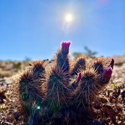
Great trails just outside Las Vegas right off the main highway. Large parking area with overflow parking on the side. There is the late night trailhead and a few others that start from this parking lot. Used for hiking, biking and horseback riding. No OHV's. The dirt road going back into the valley is drivable and will lead you to the black velvet canyon trailhead which is also a great hike and is only for hikers. **Note for hikers** I recommend walking the trail backwards, that would be starting facing Vegas. This allows you to see the bikers coming instead of hope it the yell or ring a bell as they come down the hills. Wonderful views of the red rock canyon. Great cactus and desert vibes.

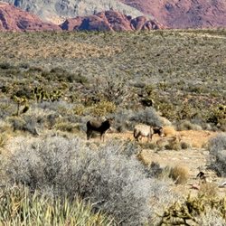
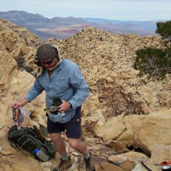
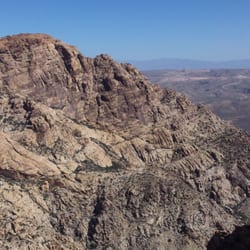
This is my third time out here at this trailhead. It was a beautiful Sunday morning and another great day to be outside. This is an easy trailhead to locate as it is right off Highway 160 heading towards Pahrump. The trail is very popular for mountain bikers and off road romps. The trail is essentially pulling double duty as a hiking/biking trail. The other times that I have been out here (during the week days) I have had the trail to myself but since we were here on a Sunday it was a little busy. There is a bathroom and multiple places to park from the regular lot to the over flow lot where you can park your horse trailers and horses. Yes, everyone and animals too are allowed in this area. There are a couple of map and informative signs that provide the history of the area and allow you to decide which trails you would like to hike. I had my daughter with me today so I took her on the Mustang Loop and added in the Old Spanish trail with a stop at the Rubber Ducky tree. The Mustang Loop is about 3.8 miles but there are many connecting trails to the loop so you can end up hiking 8-10 miles all around. The signage is not great out here but there are helpful signs at ground level. Be sure to look down from time to time to make sure that there is not a change in direction coming up on the trail. My favorite part of this trail is when you come around the mountain on the loop and the trail opens up to Red Rock canyon with views of the distant peaks. If there ever was a Kodak moment, then this is it! It definitely takes my breath away every time I see this view. Mountain bikers are courteous and you can hear them coming so you need to be aware of their presence since they have the right of way. The first time I was out here, it was spring and the desert wild flowers were blooming along with the cactus and Joshua trees. It was so magical and you would be blown away about how beautiful the desert can be in spring. Lots of insects and rodents out and about along with bunnies. We did not see any burros though. The hike itself is listed as moderate, I would rate it easy unless you are a beginner hiker or not in the best physical shape. It is a great trail to bring the kids or family to since the trail is not a challenge. I would recommend only hiking these trails in the fall, winter or spring. With the entire trail being exposed, I would not recommend hiking in the summer. A fun trail to be shared by all but remember to always Leave No Trace! Hike3 - 52 Week Hike Challenge 2020

Gorgeous trail not far from Red Rock. The trail is flat and easy with great views but be sure to listen for the bicyclists and horseback riders because they are sharing the trail with you. It's easy enough to step to the side of the trail though and continue hiking. I'll definitely return to this one!


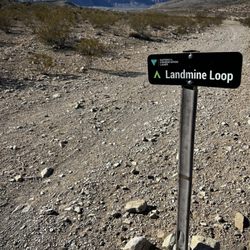
If you're a mountain bike rider or a hiker, this is one of the places to start your journey. Several years ago, the parking area was redone. It now has two parking areas--one on the east side for horse trailers and over-sized vehicles--and regular vehicle parking on the west side. There's also restroom facilities on the west side. The parking lot has some nice interpretive signs explaining when this area was used by wagons as part of the Santa Fe Trail. I came here to do a hike for a quarterly hiking article I write and to see if the hike was something our group might want to do. The trails are fairly well marked but if you're just exploring it might be good to have a GPS unit with you so you can get back to the car. There are approximately 140 miles of trail that can be used by mountain bikers, hikers, and horse riders. There is signage that's relatively new for the main trails. The other side trails have small wooden signs at almost ground level and since there are so many, you might want to check the Cottonwood Valley mountain bike trails website before going. As a starting spot for you outdoor adventure, the Late Night Trailhead is great!

A seriously well maintained mountain biking trail. All the trails are very clearly marked. You have the option to take different directions and end up coming back to the same entrance. We used google maps using the address given through yelp. We found that you have to drive about a 100 feet more than the spot on the directions- you'll notice the large sign, "Late Night Trail." There are a lot of up and down hills. If you are a novice mountain biker, you may want to take a look before heading down the hills. Remember to not look at the rocks, and look ahead while standing a bit up from the bike, so you can avoid face planting. The scenery is breathtaking and gorgeous. There are restrooms (I didn't use them so I can't attest to their conditions). Ample parking- just lock up your stuff away from anybody's view. We went in the late afternoon and noticed a sheriff deputy patrolling the parking lot. We felt very safe. Otherwise, I wouldn't bring any valuables in the car.

I ride here often and I have to say that the trails are amazing! There are numerous trails with a wide range of difficultly ratings. So if you're new to Mountain Biking, there are definitely trails that you'll be comfortable riding! On the other hand, if you're a pro you won't be disappointed! My favorite trail is 3 mile smile! It's technical and fun! After you get through the switch backs, you can fly down the remainder of the mountain through some twists and turns and get some air flying over the mound at the bottom of the mountain! Super fun!!! You'll have to take badger pass to get there. I'll worn you, Badger Pass is a long, slow, grueling uphill climb. Although I admit that the view at the top is beautiful! I added a pic! I tried Late night Trail today! It's tough and incredible technical! You're literally balancing your bike through large rock gardens and between boulders. Much of it is uphill, until you reach Black Velvet Trail. This one is definitely not on my favorites Addinga couple of pics I took! Check back for a new Vid! By the way, check out my new site for additional ideas on some more outdoor activities that will help you stay fit and healthy! www.travelandcoast.com Leave a comment to let me know what you think to help me improve the site!

Park here, off of State Route 160, for easy access to the network of mixed use (mountain biking, trail running, hiking) trails in the southern sector of Red Rock Canyon. The Late Night Trailhead is also known locally as the Cottonwood Trail area. There's always plenty of parking, and a clean toilet. From the TH a network of trails fans out both north and south to all corners of the local topography. There's a trial for all levels here, from a 20 mile trek with plenty of climbing through the neighboring mountain range, to short flat-ish loops in the high desert. Because of the variety of trails, this is generally the first address local mountain bikers direct a newcomer to the valley. Like the name, this is the perfect access point for cool outdoor night-time adventures during Vegas' long hot summers. ### Here's a link to the official trail map from the BLM (copy-paste into your browser): https://eplanning.blm.gov/epl-front-office/projects/nepa/9752/17356/17556/CottonwoodTrail.pdf

Went here for a morning hike with a friend and so glad we went here! Lovely place and it was a beautiful weather (70's). The best thing about the place that it's pretty close to city. No need to drive far to enjoy the nature. Plenty of parking space and restroom is available at the site. This trail is considered an easy one, for beginner. It's perfect for family of all ages, even with younger kids. Not much of a climb and you can see lots of wild desert animals around such as bunnies, lizards, or burros. One thing to note if you are parents with younger kids, you should watch out for the mountain biker around. They can go really fast and for them, the trip on the way back downhill is their reward so they tend not to slow down, no matter what. Will come back again for another hike.

Came here for a little bit of mountain biking. We wanted to bike trails that were not too intense and were more flat. Here is were you will find both. There are flat dirt trails that were a little rocky and there are trails that are rocky and kinda intense going up hill. But the uphill part is not that bad. A lot of the uphill parts you have a downhill section to build up some speed up before climbing. I felt really safe to because there was a police officer in an suv patrolling the parking lot for car thieves.

I'm not sure why this is called the Late Night Trail. Maybe I should have read the sign in the parking lot to find out? Anyway, the funny thing is I actually hiked here late at night. Now normally I don't recommend this sort of thing, there being coyotes, bandits, and white walkers and all...but luckily, we were part of a group that was being led by Aaron, an employee of Red Rock Park. Our goal was to watch a meteor shower. As for the trail itself, it is not much of a hike as it is just walking. The trail is flat and very easy and circles around a large hill. I want to say it was about 3 miles round-trip. During the day there's not much to see on this trail and I honestly wouldn't recommend it- it could get pretty boring. But at night, however, it's a much different story. You have a huge expanse of sky above you with very little light pollution from the city. It's perfect for star gazing and the flat trail proves helpful in the dark. Just be extremely careful if you are here at night and hike with others. During our hike we saw a darkling beetle, a lone burro, and some bats. No meteors. This is apparently a very popular area to bike and I found many websites about biking this trail when researching for our hike. So in summary: -I don't know how this trail got its name -It's an easy hike but pretty boring during the day -It makes for a good hike at night (maybe that's how it got its name?) -Bike riders love it here -There are restrooms at the trailhead, but don't expect 4-star facilities, or even 2-star for that matter -I really recommend the Red Rock night hikes On the 160, about a mile or so north of the Blue Diamond travel plaza (heading towards Pahrump). Look for the parking lot on the right hand side. This website has some helpful pictures and directions: http://www.birdandhike.com/Hike/Red_Rocks/Trailheads/LateNite/_LateNte.htm

Lovely beginner trails and interesting enough for the intermediate rider too-- just add speed and head over to the the hurl, techno, red valley for some splash of rocks! Flowy and easy to decipher trails/ they're marked at the "corners." Make sure when you take beginners let them have a looksie on the rock drops... So they can decide if they can put their body in the correct spot... Or just walk down or up... Southwest bikes was super nice and sweet to some newer MTB people! I went back in hopes to ride badger pass, techno, wht rhino, red valley, Spanish trail-- blue diamond loop for the return... Totally easy to spend 2.5 hours or more here! Beautiful red rocks for view... Just be careful when you fall-- it's sharp everywhere -- cholla, thorn bushes, sharp rocks... You got the "point?" Jajajaaja

4 months ago
Nice trails off the main highway on the way from Vegas to pahrump that are free to access and do have a restroom. The trails go for a bit and have beautiful views of the mountains all around. Overall, the trails are pretty flat and are in the easier side, with lots of grave/rocks though. Much of the hike is in direct sun, so be prepared for that if coming mid-day. The rubber ducky trail is off of here where you can see the tree decorated with rubber ducks. It's a bit silly, but is a fun draw for the area. read more


Wow, what a wonderful trailhead! Note that this trailhead is in the middle of nowhere before you reach Pahrump, so there is absolutely no cellphone reception in the area. This is a great trailhead for those that are new to hiking or just love hiking in general. The trails are mostly flat that loops around (5 miles total) and you have amazing Mountain View's all around. It was really windy that day so because of this we didn't hike the whole 5 miles. Though I was wearing the appropriate shoes and had a full bottle of water and walking sticks on me, I still felt like I wasn't really prepared for this trail, since I had my hands full and I did not have a backpack on me. Though I live in Henderson, making the 30+ minute drive out of the city to hike Late Night was definitely worth it! While it was windy overall, the temperature wasn't too hot or too cold to hike. read more


Great trails just outside Las Vegas right off the main highway. Large parking area with overflow parking on the side. There is the late night trailhead and a few others that start from this parking lot. Used for hiking, biking and horseback riding. No OHV's. The dirt road going back into the valley is drivable and will lead you to the black velvet canyon trailhead which is also a great hike and is only for hikers. **Note for hikers** I recommend walking the trail backwards, that would be starting facing Vegas. This allows you to see the bikers coming instead of hope it the yell or ring a bell as they come down the hills. Wonderful views of the red rock canyon. Great cactus and desert vibes. read more


This is my third time out here at this trailhead. It was a beautiful Sunday morning and another great day to be outside. This is an easy trailhead to locate as it is right off Highway 160 heading towards Pahrump. The trail is very popular for mountain bikers and off road romps. The trail is essentially pulling double duty as a hiking/biking trail. The other times that I have been out here (during the week days) I have had the trail to myself but since we were here on a Sunday it was a little busy. There is a bathroom and multiple places to park from the regular lot to the over flow lot where you can park your horse trailers and horses. Yes, everyone and animals too are allowed in this area. There are a couple of map and informative signs that provide the history of the area and allow you to decide which trails you would like to hike. I had my daughter with me today so I took her on the Mustang Loop and added in the Old Spanish trail with a stop at the Rubber Ducky tree. The Mustang Loop is about 3.8 miles but there are many connecting trails to the loop so you can end up hiking 8-10 miles all around. The signage is not great out here but there are helpful signs at ground level. Be sure to look down from time to time to make sure that there is not a change in direction coming up on the trail. My favorite part of this trail is when you come around the mountain on the loop and the trail opens up to Red Rock canyon with views of the distant peaks. If there ever was a Kodak moment, then this is it! It definitely takes my breath away every time I see this view. Mountain bikers are courteous and you can hear them coming so you need to be aware of their presence since they have the right of way. The first time I was out here, it was spring and the desert wild flowers were blooming along with the cactus and Joshua trees. It was so magical and you would be blown away about how beautiful the desert can be in spring. Lots of insects and rodents out and about along with bunnies. We did not see any burros though. The hike itself is listed as moderate, I would rate it easy unless you are a beginner hiker or not in the best physical shape. It is a great trail to bring the kids or family to since the trail is not a challenge. I would recommend only hiking these trails in the fall, winter or spring. With the entire trail being exposed, I would not recommend hiking in the summer. A fun trail to be shared by all but remember to always Leave No Trace! Hike3 - 52 Week Hike Challenge 2020 read more


4 years ago
Gorgeous trail not far from Red Rock. The trail is flat and easy with great views but be sure to listen for the bicyclists and horseback riders because they are sharing the trail with you. It's easy enough to step to the side of the trail though and continue hiking. I'll definitely return to this one! read more


3 years ago
Son and I come here often. We mostly go to beginner mustang loop. We love this trail. There's so much to do! But when I'm with my MTB group we'd hit up 3 miles smile it's a nice workout! read more


If you're a mountain bike rider or a hiker, this is one of the places to start your journey. Several years ago, the parking area was redone. It now has two parking areas--one on the east side for horse trailers and over-sized vehicles--and regular vehicle parking on the west side. There's also restroom facilities on the west side. The parking lot has some nice interpretive signs explaining when this area was used by wagons as part of the Santa Fe Trail. I came here to do a hike for a quarterly hiking article I write and to see if the hike was something our group might want to do. The trails are fairly well marked but if you're just exploring it might be good to have a GPS unit with you so you can get back to the car. There are approximately 140 miles of trail that can be used by mountain bikers, hikers, and horse riders. There is signage that's relatively new for the main trails. The other side trails have small wooden signs at almost ground level and since there are so many, you might want to check the Cottonwood Valley mountain bike trails website before going. As a starting spot for you outdoor adventure, the Late Night Trailhead is great! read more


A seriously well maintained mountain biking trail. All the trails are very clearly marked. You have the option to take different directions and end up coming back to the same entrance. We used google maps using the address given through yelp. We found that you have to drive about a 100 feet more than the spot on the directions- you'll notice the large sign, "Late Night Trail." There are a lot of up and down hills. If you are a novice mountain biker, you may want to take a look before heading down the hills. Remember to not look at the rocks, and look ahead while standing a bit up from the bike, so you can avoid face planting. The scenery is breathtaking and gorgeous. There are restrooms (I didn't use them so I can't attest to their conditions). Ample parking- just lock up your stuff away from anybody's view. We went in the late afternoon and noticed a sheriff deputy patrolling the parking lot. We felt very safe. Otherwise, I wouldn't bring any valuables in the car. read more


I ride here often and I have to say that the trails are amazing! There are numerous trails with a wide range of difficultly ratings. So if you're new to Mountain Biking, there are definitely trails that you'll be comfortable riding! On the other hand, if you're a pro you won't be disappointed! My favorite trail is 3 mile smile! It's technical and fun! After you get through the switch backs, you can fly down the remainder of the mountain through some twists and turns and get some air flying over the mound at the bottom of the mountain! Super fun!!! You'll have to take badger pass to get there. I'll worn you, Badger Pass is a long, slow, grueling uphill climb. Although I admit that the view at the top is beautiful! I added a pic! I tried Late night Trail today! It's tough and incredible technical! You're literally balancing your bike through large rock gardens and between boulders. Much of it is uphill, until you reach Black Velvet Trail. This one is definitely not on my favorites Addinga couple of pics I took! Check back for a new Vid! By the way, check out my new site for additional ideas on some more outdoor activities that will help you stay fit and healthy! www.travelandcoast.com Leave a comment to let me know what you think to help me improve the site! read more


Park here, off of State Route 160, for easy access to the network of mixed use (mountain biking, trail running, hiking) trails in the southern sector of Red Rock Canyon. The Late Night Trailhead is also known locally as the Cottonwood Trail area. There's always plenty of parking, and a clean toilet. From the TH a network of trails fans out both north and south to all corners of the local topography. There's a trial for all levels here, from a 20 mile trek with plenty of climbing through the neighboring mountain range, to short flat-ish loops in the high desert. Because of the variety of trails, this is generally the first address local mountain bikers direct a newcomer to the valley. Like the name, this is the perfect access point for cool outdoor night-time adventures during Vegas' long hot summers. ### Here's a link to the official trail map from the BLM (copy-paste into your browser): https://eplanning.blm.gov/epl-front-office/projects/nepa/9752/17356/17556/CottonwoodTrail.pdf read more


8 years ago
Went here for a morning hike with a friend and so glad we went here! Lovely place and it was a beautiful weather (70's). The best thing about the place that it's pretty close to city. No need to drive far to enjoy the nature. Plenty of parking space and restroom is available at the site. This trail is considered an easy one, for beginner. It's perfect for family of all ages, even with younger kids. Not much of a climb and you can see lots of wild desert animals around such as bunnies, lizards, or burros. One thing to note if you are parents with younger kids, you should watch out for the mountain biker around. They can go really fast and for them, the trip on the way back downhill is their reward so they tend not to slow down, no matter what. Will come back again for another hike. read more


Came here for a little bit of mountain biking. We wanted to bike trails that were not too intense and were more flat. Here is were you will find both. There are flat dirt trails that were a little rocky and there are trails that are rocky and kinda intense going up hill. But the uphill part is not that bad. A lot of the uphill parts you have a downhill section to build up some speed up before climbing. I felt really safe to because there was a police officer in an suv patrolling the parking lot for car thieves. read more


I'm not sure why this is called the Late Night Trail. Maybe I should have read the sign in the parking lot to find out? Anyway, the funny thing is I actually hiked here late at night. Now normally I don't recommend this sort of thing, there being coyotes, bandits, and white walkers and all...but luckily, we were part of a group that was being led by Aaron, an employee of Red Rock Park. Our goal was to watch a meteor shower. As for the trail itself, it is not much of a hike as it is just walking. The trail is flat and very easy and circles around a large hill. I want to say it was about 3 miles round-trip. During the day there's not much to see on this trail and I honestly wouldn't recommend it- it could get pretty boring. But at night, however, it's a much different story. You have a huge expanse of sky above you with very little light pollution from the city. It's perfect for star gazing and the flat trail proves helpful in the dark. Just be extremely careful if you are here at night and hike with others. During our hike we saw a darkling beetle, a lone burro, and some bats. No meteors. This is apparently a very popular area to bike and I found many websites about biking this trail when researching for our hike. So in summary: -I don't know how this trail got its name -It's an easy hike but pretty boring during the day -It makes for a good hike at night (maybe that's how it got its name?) -Bike riders love it here -There are restrooms at the trailhead, but don't expect 4-star facilities, or even 2-star for that matter -I really recommend the Red Rock night hikes On the 160, about a mile or so north of the Blue Diamond travel plaza (heading towards Pahrump). Look for the parking lot on the right hand side. This website has some helpful pictures and directions: http://www.birdandhike.com/Hike/Red_Rocks/Trailheads/LateNite/_LateNte.htm read more


Lovely beginner trails and interesting enough for the intermediate rider too-- just add speed and head over to the the hurl, techno, red valley for some splash of rocks! Flowy and easy to decipher trails/ they're marked at the "corners." Make sure when you take beginners let them have a looksie on the rock drops... So they can decide if they can put their body in the correct spot... Or just walk down or up... Southwest bikes was super nice and sweet to some newer MTB people! I went back in hopes to ride badger pass, techno, wht rhino, red valley, Spanish trail-- blue diamond loop for the return... Totally easy to spend 2.5 hours or more here! Beautiful red rocks for view... Just be careful when you fall-- it's sharp everywhere -- cholla, thorn bushes, sharp rocks... You got the "point?" Jajajaaja read more

 - Hiking Near Me - Blue Diamond, Nevada")


All i can say is WOW! I saddled our mountain bikes to the car and headed out to explore the trails out here. IMHO its probably the best place in the valley to take your mountain bike. The trails were clearly marked and well established. We only had enough time to do a loop around the backside of the mountain but i can tell you the scenary of the back country is amazing! I come to Red Rock canyon every weekend to bike, hike and explore and i am never disappointed. On the downhill, i was really flying and caught air more than a few times which reminded me of myself as a teenager racing BMX! Fun times i tell ya! If you have a mountain bike collecting dust in your garage, load it up and head to Late Night Trailhead. You will be glad you did. The best part? Its free!!! ( insert applause here ) Now is the best time to do it since the temps are in the 80's. If you wait much longer, it will be very hot necessitating a very early a.m. ride. Bring a back pack, sun block, water, snacks, the usual stuff, especially a camera. Its literally a photo safari back here. AAA +++ read more


8 years ago
8 years ago
11 years ago
More info about Late Night Trailhead
Ask the Community - Late Night Trailhead
Can I park here even after 8pm to stargaze? Planning on taking the telescope out for a spin
I think They lick the gate at 8 pm. Another option would be to go up 159 about a mile more and turn left onto that dirt road and park there.
Is this Trail for bikes only or people can take their vehicles out there?
Review Highlights - Late Night Trailhead
You might also consider


Why does Yelp recommend reviews?
1 review that is not currently recommended
The reviews below are not factored into the business's overall star rating.
9 years ago
Late Night Trailhead - hiking - Updated July 2026
Best of Blue Diamond
People found Late Night Trailhead by searching for…
Horseback Riding in Blue Diamond, NV
Lookout Points in Blue Diamond, NV
Fishing Spots in Blue Diamond, NV
Public Running Track in Blue Diamond, NV
Abandoned Places in Blue Diamond, NV
River Swimming in Blue Diamond, NV
Walking Trails in Blue Diamond, NV
Places to Take Pictures in Blue Diamond, NV
Hiking Trails in Blue Diamond, NV
Off Road Trails in Blue Diamond, NV
Easy Hikes in Blue Diamond, NV
Public Shower in Blue Diamond, NV
Dirt Bike Riding in Blue Diamond, NV
Scenic Views in Blue Diamond, NV
Night View in Blue Diamond, NV
Night Hike in Blue Diamond, NV
Star Gazing in Blue Diamond, NV
Make Out Spot in Blue Diamond, NV
Full Moon Hike in Blue Diamond, NV
Stargazing in Blue Diamond, NV
Meteor Shower in Blue Diamond, NV
Trending Searches in Blue Diamond, NV
Cliff Jumping near Late Night Trailhead
Day Trips near Late Night Trailhead
Free Picnic Areas near Late Night Trailhead
Free Things To Do With Kids near Late Night Trailhead
Jet Ski Rental near Late Night Trailhead
Kayak Rental near Late Night Trailhead
Lakes & Ponds near Late Night Trailhead
Lookout Points near Late Night Trailhead
Off Road Trails near Late Night Trailhead
Outdoor Activities near Late Night Trailhead
Outdoor Basketball Courts near Late Night Trailhead
Parks near Late Night Trailhead
Parks For Picnics near Late Night Trailhead
Picnic Spots near Late Night Trailhead
Places To Swim near Late Night Trailhead
Pokemon Go near Late Night Trailhead
Pool Day Pass near Late Night Trailhead
Public Shower near Late Night Trailhead
Public Swimming Pools near Late Night Trailhead
River Swimming near Late Night Trailhead
Rock Quarry near Late Night Trailhead
Scenic Night View near Late Night Trailhead
Scenic Overlook near Late Night Trailhead
Secluded Spots near Late Night Trailhead
Skyline View near Late Night Trailhead
Soccer Store near Late Night Trailhead
Star Gazing near Late Night Trailhead
Swimming Holes near Late Night Trailhead
Swimming Lakes near Late Night Trailhead
Watch Sunset near Late Night Trailhead
Water Activities near Late Night Trailhead
Browse Nearby
Browse Brands
Related Searches in Blue Diamond, NV
Affordable Bike Repair Services in Blue Diamond, Nevada
Affordable Canoe Rental Options in Blue Diamond, Nevada
Affordable Kayak Rental Services in Blue Diamond, Nevada
Best Dirt Bike Riding Spots in Blue Diamond, Nevada
Best Dog Hiking Trails Around Blue Diamond, Nevada
Best Electric Bike Rental Services in Blue Diamond, Nevada
Best Fishing Locations and Guides in Blue Diamond, Nevada
Best Off Leash Dog Parks in Blue Diamond, Nevada
Best Parks for Parties and Events in Blue Diamond, Nevada
Best Places for Horseback Riding in Blue Diamond, Nevada
Best Sightseeing Experiences Available in Blue Diamond, Nevada
Best Sledding Spots and Fun in Blue Diamond, Nevada
Best Used Bikes for Sale Near Blue Diamond, Nevada
Best Water Parks for Kids in Blue Diamond, Nevada
Check Out Great Playgrounds in Blue Diamond, Nevada
Check Out Off Road Trails in Blue Diamond, Nevada
Discover Baseball Fields Around Blue Diamond, Nevada
Discover Dog Friendly Trails to Explore in Blue Diamond, Nevada
Discover Fun Toddler Parks in Blue Diamond, Nevada for Your Little One
Discover Lakes & Ponds to Explore in Blue Diamond, Nevada
Discover Popular Bike Tours in Blue Diamond, Nevada
Discover Popular Bike Trails in Blue Diamond, Nevada
Discover Popular Photo Spots in Blue Diamond, Nevada
Discover Scenic Bike Paths in Blue Diamond, Nevada
Discover Scenic Mountain Bike Trails Near Blue Diamond, Nevada
Discover Soccer Fields in Blue Diamond, Nevada Near You
Discover Top Nature Parks to Visit in Blue Diamond, Nevada
Discover the Best Beaches in Blue Diamond, Nevada
Discover the Best Kids Park Spots in Blue Diamond, Nevada
Discover the Best Night Hike Trails in Blue Diamond, Nevada
Dog-Friendly Hikes With Dogs in Blue Diamond, Nevada
Enjoy Camping Adventures Around Blue Diamond, Nevada
Enjoy Hiking Adventures in Blue Diamond, Nevada
Enjoy Kayaking Adventures in Blue Diamond, Nevada
Enjoy Off Leash Dog Hikes in Blue Diamond, Nevada
Enjoy Tent Camping Spots Around Blue Diamond, Nevada
Enjoy the Best Picnic Spots and Ideas in Blue Diamond, Nevada
Enjoy the Best Tubing Experiences in Blue Diamond, Nevada
Enjoy the Best Walking Path in Blue Diamond, Nevada
Enjoy the Best Walking Trails in Blue Diamond, Nevada
Explore BMX Bike Shops Near Blue Diamond, Nevada
Explore Beautiful Parks and Green Spaces in Blue Diamond, Nevada
Explore Bike Rentals Throughout Blue Diamond, Nevada
Explore Easy Hikes Perfect for All in Blue Diamond, Nevada
Explore Electric Bikes Available in Blue Diamond, Nevada
Explore Family-Friendly Zoos and Wildlife in Blue Diamond, Nevada
Browse Articles
People who viewed Late Night Trailhead also viewed
Mary Jane Falls
111 reviews
Spring Mountain Ranch State Park
157 reviews
Sunrise Mountain/Frenchman Mountain
56 reviews
Sunrise
Sandstone Canyon Trail
2 reviews
Rocky Gap Road
2 reviews
Cave Canyon
2 reviews
Sandstone Quarry
5 reviews
Cottonwood Canyon Park
46 reviews
Summerlin
Peccole Ranch Walking Trail
57 reviews
South Summerlin, Westside
Brownstone Canyon
4 reviews