James Brown Trail Photos


You might also consider
More like James Brown Trail
Recommended Reviews - James Brown Trail
Start your review...

Reviews With Photos

I had no idea this trail had a name. We've been hiking this for years! It's right behind our neighborhood. We're bummed there's more construction going on and more houses going up around it, so I hope they never mess with this! It's perfect for taking the dog for some exercise without having to drive anywhere.

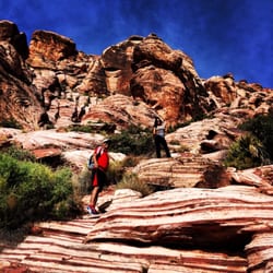
Nice spot! I parked along one of the streets nearby and just walked across the road to find the main trail. I started up what I thought was a trail, but it seemed to turn in a not-a-trail trail as I kept hiking; even so, my dog and I were able to make it up just fine. On the way down I did notice there seems to be a very noticeable, wide trail that kind of winds around the hills/peaks so next time I plan to explore that to see where it leads. I got up and down in about an hour but you could easily turn this into a longer hike by climbing higher or working your way up the peaks diagonally rather than straight vertical like my dog and I did. I'm giving four stars just because the trail is very, very rocky. You definitely will do best in hiking shoes with good grip. I'd even throw some shoes on your dog! Gripping some of the rocks to climb up, they were sharp and rough- not ideal as a grip for my hand so I can imagine it doesn't feel great on his paws. There are a few different spots you can climb to and either way the view is beautiful! We will be coming back here for sure.

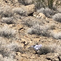
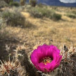
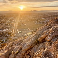
This is a great trail in the southwest area of the Valley. I had never heard of it until my husband told me about it when he hiked it last year. There are excellent views of the whole Vegas Valley from the top, Red Rock behind you and the Strip in front of you. Parking is right off of Fort Apache Road at Mountains Edge Pkwy. I highly recommend starting early to avoid a lot of people during COVID 19 times and also because there is no shade at all on this trail. We saw lots of different flowers in bloom as well as a LOT of trash; please leave no trace! There are several offshoots of the main trail that goes up to the highest view point so you can add more cardio to your hike if you'd like. Definitely coming back to do this neighborhood trek again.


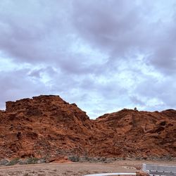
James Brown Trail (Fort Apache Rd & Mountains Edge Pkwy - Las Vegas, NV) AllTrails describes this trail as a lightly trafficked and moderate 3.6-mile round-trip hike with an elevation gain of 547 feet. For the most part, I agree. My Garmin and Whoop calculated 4.2 miles round-trip. Regardless, James Brown Trail is a nice change from the long peak hikes that we have been doing lately. This is one of those hikes with great views of the city and can be accomplished in less than 2 hours. The start of the trail is actually a dirt road. Follow the vehicle tracks up the small hill. The hill is short, but steep. After the first hill, you'll reach a hard right. From here, deviate from the dirt road and follow the trail heading left towards the moutain. The trail from there is well-defined and leads to the top. Except a lone hiker heading up as we were heading down, we didn't see any other wildlife. Overall, I like James Brown Trail. The hike was quick, quiet, and long enough to burn a few calories. I feel good!! Tip #1: Trailhead and parking is located at Fort Apache Rd & Mountains Edge Pkwy. Tip #2: There are no signs to the trailhead. Just follow the trail towards the small hill to the right. Tip #3: Bring a good pair of shoes. I made the mistake of forgetting my hike boots. I know, what a newbie move. Tip #4: Terrain is dirt and loose rock. Watch your step, especially on the way down. Tip #5: I have no idea why this hike is named James Brown Trail.

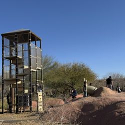
At the end of Mountains Edge Pkwy and Fort Apache you'll run into desert. You can park and walk or drive your car up the dirt path and start your hike. All of the trails are unmarked but you can see other peoples walking paths to follow. There isn't much to see besides a abandon structure that's been spray painted, lots of garbage and a beautiful view of Mountains Edge. The terrain is desert landscaping so we're close the shoes and make sure to bring water. I did notice a few people riding their mountain bikes in the area. Also, we stayed on the right side of the mountain (because I had my 5 & 3 year old with me) however, I did see people walking out to the left. So I'm sure there are more things to explore overs there.

2 years ago
This hike is like Mountains Edge exploration park hike x10! Love the that it's in the Valley and not too far from my house but still a pretty long hike with multiple little trails. read more
1 year ago
Did you know that Mountain's Edge has other hikeable peaks besides the Exploration Peak? Yes it is true. West of Fort Apache at Mountain's Edge Pkwy starts a trail leading up to one of these such peaks overlooking Mountain's Edge. I wouldn't have known if I hadn't looked it up on AllTrails and and even after that I felt sceptical about the info there. It was named the James Brown Trail and had a bunch of different trail records. Anyways I chanced it and here we are now. There's no trailhead sign or parking lot. I just parked off the road, in some open area which looked like where people could park behind some cement barriers. Careful you don't park in something you'd get your car stuck in. There's no parking signs alone the paved Fort Apache. From here you'll follow a dirt road west up a hill. You'll then follow the road south until the road shrink and almost disappears to a smaller rocky trail. You just follow it up to the top. Love the view at the top. You can see everything in Mountain's Edge. There's also the Strip in the distance and the much smaller Exploration Peak. Now you hike back down. Be careful the trail is rocky, you could slip and fall. The hike is about 4 miles +/- half a mile I'm guessing. I kind of want to see the sunset from the top one day. South of the peak there's another peak which looks even taller and I want to hike to but have yet to find any trail info. A little help please. Nice hike up and down with a view. I'd hike it again. I've heard people walk their dogs up and ride their bikes in the area so keep your eyes out for them. read more


I had no idea this trail had a name. We've been hiking this for years! It's right behind our neighborhood. We're bummed there's more construction going on and more houses going up around it, so I hope they never mess with this! It's perfect for taking the dog for some exercise without having to drive anywhere. read more


Nice spot! I parked along one of the streets nearby and just walked across the road to find the main trail. I started up what I thought was a trail, but it seemed to turn in a not-a-trail trail as I kept hiking; even so, my dog and I were able to make it up just fine. On the way down I did notice there seems to be a very noticeable, wide trail that kind of winds around the hills/peaks so next time I plan to explore that to see where it leads. I got up and down in about an hour but you could easily turn this into a longer hike by climbing higher or working your way up the peaks diagonally rather than straight vertical like my dog and I did. I'm giving four stars just because the trail is very, very rocky. You definitely will do best in hiking shoes with good grip. I'd even throw some shoes on your dog! Gripping some of the rocks to climb up, they were sharp and rough- not ideal as a grip for my hand so I can imagine it doesn't feel great on his paws. There are a few different spots you can climb to and either way the view is beautiful! We will be coming back here for sure. read more


This is a great trail in the southwest area of the Valley. I had never heard of it until my husband told me about it when he hiked it last year. There are excellent views of the whole Vegas Valley from the top, Red Rock behind you and the Strip in front of you. Parking is right off of Fort Apache Road at Mountains Edge Pkwy. I highly recommend starting early to avoid a lot of people during COVID 19 times and also because there is no shade at all on this trail. We saw lots of different flowers in bloom as well as a LOT of trash; please leave no trace! There are several offshoots of the main trail that goes up to the highest view point so you can add more cardio to your hike if you'd like. Definitely coming back to do this neighborhood trek again. read more


James Brown Trail (Fort Apache Rd & Mountains Edge Pkwy - Las Vegas, NV) AllTrails describes this trail as a lightly trafficked and moderate 3.6-mile round-trip hike with an elevation gain of 547 feet. For the most part, I agree. My Garmin and Whoop calculated 4.2 miles round-trip. Regardless, James Brown Trail is a nice change from the long peak hikes that we have been doing lately. This is one of those hikes with great views of the city and can be accomplished in less than 2 hours. The start of the trail is actually a dirt road. Follow the vehicle tracks up the small hill. The hill is short, but steep. After the first hill, you'll reach a hard right. From here, deviate from the dirt road and follow the trail heading left towards the moutain. The trail from there is well-defined and leads to the top. Except a lone hiker heading up as we were heading down, we didn't see any other wildlife. Overall, I like James Brown Trail. The hike was quick, quiet, and long enough to burn a few calories. I feel good!! Tip #1: Trailhead and parking is located at Fort Apache Rd & Mountains Edge Pkwy. Tip #2: There are no signs to the trailhead. Just follow the trail towards the small hill to the right. Tip #3: Bring a good pair of shoes. I made the mistake of forgetting my hike boots. I know, what a newbie move. Tip #4: Terrain is dirt and loose rock. Watch your step, especially on the way down. Tip #5: I have no idea why this hike is named James Brown Trail. read more


 - Hiking Near Me - Las Vegas, Nevada")


 - Hiking Near Me - Las Vegas, Nevada")


At the end of Mountains Edge Pkwy and Fort Apache you'll run into desert. You can park and walk or drive your car up the dirt path and start your hike. All of the trails are unmarked but you can see other peoples walking paths to follow. There isn't much to see besides a abandon structure that's been spray painted, lots of garbage and a beautiful view of Mountains Edge. The terrain is desert landscaping so we're close the shoes and make sure to bring water. I did notice a few people riding their mountain bikes in the area. Also, we stayed on the right side of the mountain (because I had my 5 & 3 year old with me) however, I did see people walking out to the left. So I'm sure there are more things to explore overs there. read more

6 years ago
Great little trail in southwest. Ran into people on quads and dirt bikes. Unpaved, loose rock. Walked a mile up and you can get a nice view of the strip and Red Rocks. read more

4 years ago
More info about James Brown Trail
W Mountains Edge Pkwy & S Fort Apache Rd
Las Vegas, NV 89141
Southwest
Directions
Hours
Outdoor Amenities
Ask the Community - James Brown Trail
Review Highlights - James Brown Trail
You might also consider


James Brown Trail - hiking - Updated July 2026
Best of Las Vegas
People found James Brown Trail by searching for…
Abandoned Places in Las Vegas, NV
Hiking Trails in Las Vegas, NV
Dirt Bike Riding in Las Vegas, NV
Walking Trails in Las Vegas, NV
Off Road Trails in Las Vegas, NV
Running Trails in Las Vegas, NV
Rollerblading in Las Vegas, NV
Scenic Overlook in Las Vegas, NV
Beautiful Views in Las Vegas, NV
Jogging Trails in Las Vegas, NV
Trending Searches in Las Vegas, NV
Cliff Jumping near James Brown Trail
Day Trips near James Brown Trail
Dog Friendly Beaches near James Brown Trail
Dog Friendly Trails near James Brown Trail
Free Picnic Areas near James Brown Trail
Fruit Picking near James Brown Trail
Hikes With Dogs near James Brown Trail
Jet Ski Rental near James Brown Trail
Kayak Rental near James Brown Trail
Lakes & Ponds near James Brown Trail
Lookout Points near James Brown Trail
Nature Trails near James Brown Trail
Off Road Trails near James Brown Trail
Outdoor Activities near James Brown Trail
Picnic Spots near James Brown Trail
Places To Swim near James Brown Trail
Places To Walk Around near James Brown Trail
Pokemon Go near James Brown Trail
Pool Day Pass near James Brown Trail
Public Shower near James Brown Trail
Public Swimming Pools near James Brown Trail
River Swimming near James Brown Trail
River Tubing near James Brown Trail
Rock Quarry near James Brown Trail
Scenic Night View near James Brown Trail
Scenic Overlook near James Brown Trail
Secluded Spots near James Brown Trail
Soccer Store near James Brown Trail
Star Gazing near James Brown Trail
Sunrise View near James Brown Trail
Swimming Holes near James Brown Trail
Swimming Lakes near James Brown Trail
U Pick Farms near James Brown Trail
Browse Nearby
BEST of Las Vegas, Nevada Walking Trails near James Brown Trail
BEST of Las Vegas, Nevada Restaurants near James Brown Trail
BEST of Las Vegas, Nevada Coffee near James Brown Trail
BEST of Las Vegas, Nevada Things to Do near James Brown Trail
BEST of Las Vegas, Nevada Parks near James Brown Trail
BEST of Las Vegas, Nevada Breakfast near James Brown Trail
BEST of Las Vegas, Nevada Campgrounds near James Brown Trail
Browse Brands
Related Searches in Las Vegas, NV
Affordable Bike Repair Services in Las Vegas, Nevada
Affordable Cheap Bike Tune Up Services in Las Vegas, Nevada
Affordable Electric Scooter Rental in Las Vegas, Nevada
Affordable Kayak Rental Services in Las Vegas, Nevada
Affordable Road Bike Rental in Las Vegas, Nevada
Best Dirt Bike Riding Spots in Las Vegas, Nevada
Best Dog Hiking Trails Around Las Vegas, Nevada
Best Electric Bike Rental Services in Las Vegas, Nevada
Best Fishing Locations and Guides in Las Vegas, Nevada
Best Places for Horseback Riding in Las Vegas, Nevada
Best Sightseeing Experiences Available in Las Vegas, Nevada
Best Sledding Spots and Fun in Las Vegas, Nevada
Check Out Off Road Trails in Las Vegas, Nevada
Discover Dog Friendly Trails to Explore in Las Vegas, Nevada
Discover Popular Bike Tours in Las Vegas, Nevada
Discover Popular Bike Trails in Las Vegas, Nevada
Discover Scenic Bike Paths in Las Vegas, Nevada
Discover Scenic Mountain Bike Trails Near Las Vegas, Nevada
Discover Walking Parks in Las Vegas, Nevada Near You
Discover a Hiking Trail in Las Vegas, Nevada
Discover the Best Night Hike Trails in Las Vegas, Nevada
Dog-Friendly Hikes With Dogs in Las Vegas, Nevada
Enjoy Biking Adventures Around Las Vegas, Nevada
Enjoy Camping Adventures Around Las Vegas, Nevada
Enjoy Exciting Mountain Biking Adventures in Las Vegas, Nevada
Enjoy Hiking Adventures in Las Vegas, Nevada
Enjoy Kayaking Adventures in Las Vegas, Nevada
Enjoy Off Leash Dog Hikes in Las Vegas, Nevada
Enjoy Scenic Places to Walk in Las Vegas, Nevada
Enjoy Tent Camping Spots Around Las Vegas, Nevada
Enjoy a Beautiful Waterfall Hike in Las Vegas, Nevada
Enjoy the Best Walking Path in Las Vegas, Nevada
Enjoy the Best Walking Trails in Las Vegas, Nevada
Explore BMX Bike Shops Near Las Vegas, Nevada
Explore Beautiful Parks and Green Spaces in Las Vegas, Nevada
Explore Bike Rentals Throughout Las Vegas, Nevada
Explore Cycling Stores in Las Vegas, Nevada
Explore Easy Hikes Perfect for All in Las Vegas, Nevada
Explore Electric Bikes Available in Las Vegas, Nevada
Explore Fun Activities to Do in Las Vegas, Nevada
Explore Popular Campgrounds Near Las Vegas, Nevada
Explore Popular Dog Walking Trails in Las Vegas, Nevada
Explore Popular Scenic Views Near Las Vegas, Nevada
Explore Top Dog Parks in Las Vegas, Nevada Near You
Explore Top Water Parks in Las Vegas, Nevada Today
Explore the Best Rock Climbing Areas in Las Vegas, Nevada