LeTort Spring Run Nature Trail Photos


You might also consider
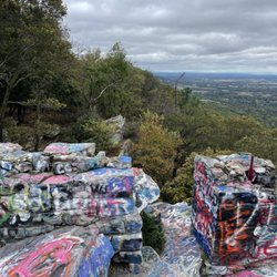
More like LeTort Spring Run Nature Trail
Recommended Reviews - LeTort Spring Run Nature Trail
Start your review...

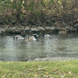
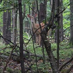
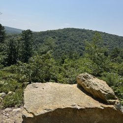
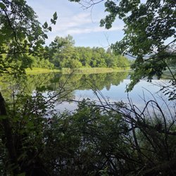
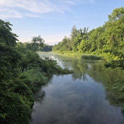
I recently discovered LeTort Spring Run and Nature Trail, and honestly, I'm still annoyed with myself for not knowing it existed sooner. I've lived in Central PA nearly my entire life--and even in Carlisle--and somehow this peaceful little gem flew completely under my radar until it popped up on social media a few weeks ago. Once I realized it was only about a 20-minute drive from my house, it immediately earned a spot on my must-visit list. Naturally, I wasted no time--early the very next Sunday morning, LeTort was my destination. According to LeTort's website (and because I love a little history with my walks): the trail is named after James LeTort, a French-Swiss trader who settled near the stream in the early 1700s. The area once hosted mills and tanneries and later became internationally known for cold-water fly fishing. Today, LeTort is famous for its limestone trout stream, bird watching, and a 2.5-mile out-and-back trail that's wide, flat, and easy to navigate. There are multiple access points, ADA-accessible fishing platforms, interpretive signage, and plenty of opportunities to feel outdoorsy without having to scale a boulder or question your life choices. I parked in the newly developed lot on South Spring Garden Street and was thrilled to find...absolutely no one else there! Sunday morning hikes are sacred to me--they're about quiet, reflection, and resetting my brain for the week ahead--so having the entire place to myself felt like winning the nature lottery. The sun was just coming up, casting that soft, golden morning light that makes everything feel calm and slightly magical. I specifically chose LeTort because it promised well-maintained, ADA-accessible paths, as opposed to my usual "billy-goating through the woods" adventures involving rocks, roots, and questionable footing. This particular Sunday, my brain was heavy and my soul needed something gentle. LeTort absolutely delivered. I didn't pass another human the entire time I was there (10/10 experience for me), but it's clear this trail would be perfect for folks with strollers, dogs, or mobility aids. The paths are wide, flat, and beautifully maintained, with lovely views along the stream. Wildlife was very much awake and active--squirrels were busy being chaotic, birds were everywhere, and a few mallard ducks were enjoying their best peaceful-morning lives. My two favorite moments from this visit really stood out. First was the view from a bridge near Bonny Brook Road, where I stopped to watch ducks gliding through the creek while squirrels chased each other across fallen trees spanning the water. It was serene, peaceful, and exactly the kind of quiet beauty I needed. The second moment surprised me: a Sharpie-marked message on a wooden signpost that read, "ALWAYS HAVE HOPE." I'm not usually a fan of graffiti, but that message hit me square in the feelings that morning and felt oddly meant just for me. Sometimes the universe shows up in weird ways--even via Sharpie. LeTort Spring Run is a solid choice for a low-impact, easy walk when you want fresh air without breaking a sweat or navigating rugged terrain. There's plenty of parking, plenty of space to move comfortably, and plenty of beauty if you're paying attention. It may not land on my frequent-visit list, but I'll absolutely keep it in mind as a future picnic spot once spring and summer roll around. Sometimes the best adventures are the quiet ones--and LeTort is a really lovely place to slow down, breathe, and just be. read more


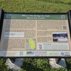
This is a rather easy and underwhelming bike trail, but an OK one for walking/jogging. The reason is it's only 1.7 miles long. The trail is narrower than a typical rail trail and is paved with crushed stones. Best parking for the trailhead is at the Lamberton Middle School. In the visitor parking just head toward the building and veer to the left and you will see the trailhead. At the end of the trail at S Spring Garden St, there's a posted sign announcing the extension of the trail all the way to Heisters Lane and is expected to be completed in July of 2021. That would add at least .9 miles to the trail, making it more presentable and worth while to visit. Officially the trail starts from LeTort Park which adds .3 mile to the length, but that would include 3 blocks of street biking interconnecting the 2 segments. By the way, LeTort Park has a nice setting for duck and goose watching if you're into that sort of thing. read more


More info about LeTort Spring Run Nature Trail
415 Franklin St
Carlisle, PA 17013
Directions
Visit Website
https://letort.org
Hours
Outdoor Amenities


LeTort Spring Run Nature Trail - hiking - Updated July 2026
Best of Carlisle
People found LeTort Spring Run Nature Trail by searching for…
Fun Things to Do in Carlisle, PA
Running Trails in Carlisle, PA
Places to Take Pictures in Carlisle, PA
Walking Trails in Carlisle, PA
Free Things to Do in Carlisle, PA
River Swimming in Carlisle, PA
Waterfall Hike in Carlisle, PA
Mountain Biking in Carlisle, PA
Park & Forests in Carlisle, PA
Trending Searches in Carlisle, PA
Blueberry Picking near LeTort Spring Run Nature Trail
Boardwalk near LeTort Spring Run Nature Trail
Cliff Jumping near LeTort Spring Run Nature Trail
Day Trips near LeTort Spring Run Nature Trail
Dog Friendly Beaches near LeTort Spring Run Nature Trail
Dog Friendly Trails near LeTort Spring Run Nature Trail
Free Picnic Areas near LeTort Spring Run Nature Trail
Free Things To Do With Kids near LeTort Spring Run Nature Trail
Jet Ski Rental near LeTort Spring Run Nature Trail
Kayak Rental near LeTort Spring Run Nature Trail
Kids Activities Outdoor near LeTort Spring Run Nature Trail
Lakes & Ponds near LeTort Spring Run Nature Trail
Off Road Trails near LeTort Spring Run Nature Trail
Outdoor Activities near LeTort Spring Run Nature Trail
Parks For Picnics near LeTort Spring Run Nature Trail
Peach Picking near LeTort Spring Run Nature Trail
Places To Swim near LeTort Spring Run Nature Trail
Pokemon Go near LeTort Spring Run Nature Trail
Pool Day Pass near LeTort Spring Run Nature Trail
Public Beaches near LeTort Spring Run Nature Trail
Public Shower near LeTort Spring Run Nature Trail
River Swimming near LeTort Spring Run Nature Trail
River Tubing near LeTort Spring Run Nature Trail
Rock Quarry near LeTort Spring Run Nature Trail
Scenic Night View near LeTort Spring Run Nature Trail
Scenic Overlook near LeTort Spring Run Nature Trail
Secluded Spots near LeTort Spring Run Nature Trail
Soccer Store near LeTort Spring Run Nature Trail
Sunrise View near LeTort Spring Run Nature Trail
Swimming Holes near LeTort Spring Run Nature Trail
Swimming Lakes near LeTort Spring Run Nature Trail
U Pick Farms near LeTort Spring Run Nature Trail
Watch Sunset near LeTort Spring Run Nature Trail
Water Parks For Kids near LeTort Spring Run Nature Trail
Waterfalls And Swimming Holes near LeTort Spring Run Nature Trail
Browse Articles
Browse Nearby
BEST of Carlisle, Pennsylvania Restaurants near LeTort Spring Run Nature Trail
BEST of Carlisle, Pennsylvania Things to Do near LeTort Spring Run Nature Trail
BEST of Carlisle, Pennsylvania Coffee near LeTort Spring Run Nature Trail
BEST of Carlisle, Pennsylvania Parks near LeTort Spring Run Nature Trail
BEST of Carlisle, Pennsylvania Walking Trails near LeTort Spring Run Nature Trail
BEST of Carlisle, Pennsylvania Breakfast near LeTort Spring Run Nature Trail
BEST of Carlisle, Pennsylvania Caves near LeTort Spring Run Nature Trail
BEST of Carlisle, Pennsylvania Campgrounds near LeTort Spring Run Nature Trail
BEST of Carlisle, Pennsylvania Day Trips near LeTort Spring Run Nature Trail
Browse Brands
Related Searches in Carlisle, PA
Affordable Canoe Rental Options in Carlisle, Pennsylvania
Affordable Kayak Rental Services in Carlisle, Pennsylvania
Best Dog Hiking Trails Around Carlisle, Pennsylvania
Best Fishing Locations and Guides in Carlisle, Pennsylvania
Best Off Leash Dog Parks in Carlisle, Pennsylvania
Best Parks for Parties and Events in Carlisle, Pennsylvania
Best Places for Horseback Riding in Carlisle, Pennsylvania
Best Water Parks for Kids in Carlisle, Pennsylvania
Best Waterfalls and Swimming Holes in Carlisle, Pennsylvania
Check Out Great Playgrounds in Carlisle, Pennsylvania
Check Out Off Road Trails in Carlisle, Pennsylvania
Discover Baseball Fields Around Carlisle, Pennsylvania
Discover Beautiful Garden Spots in Carlisle, Pennsylvania
Discover Dog Friendly Trails to Explore in Carlisle, Pennsylvania
Discover Fun Toddler Parks in Carlisle, Pennsylvania for Your Little One
Discover Kid Friendly Hiking Trails in Carlisle, Pennsylvania
Discover Lakes & Ponds to Explore in Carlisle, Pennsylvania
Discover Popular Bike Trails in Carlisle, Pennsylvania
Discover Scenic Mountain Bike Trails Near Carlisle, Pennsylvania
Discover Soccer Fields in Carlisle, Pennsylvania Near You
Discover Top Nature Parks to Visit in Carlisle, Pennsylvania
Discover Top State Parks to Visit in Carlisle, Pennsylvania
Discover a Hiking Trail in Carlisle, Pennsylvania
Discover the Best Beaches in Carlisle, Pennsylvania
Discover the Best Night Hike Trails in Carlisle, Pennsylvania
Dog-Friendly Hikes With Dogs in Carlisle, Pennsylvania
Enjoy Camping Adventures Around Carlisle, Pennsylvania
Enjoy Kayaking Adventures in Carlisle, Pennsylvania
Enjoy Off Leash Dog Hikes in Carlisle, Pennsylvania
Enjoy Tent Camping Spots Around Carlisle, Pennsylvania
Enjoy a Beautiful Waterfall Hike in Carlisle, Pennsylvania
Enjoy the Best Picnic Spots and Ideas in Carlisle, Pennsylvania
Enjoy the Best Walking Trails in Carlisle, Pennsylvania
Explore Beautiful Parks and Green Spaces in Carlisle, Pennsylvania
Explore Easy Hikes Perfect for All in Carlisle, Pennsylvania
Explore Family-Friendly Zoos and Wildlife in Carlisle, Pennsylvania
Explore Free Picnic Areas Around Carlisle, Pennsylvania
Explore Fun Activities to Do in Carlisle, Pennsylvania
Explore Parks With Pull Up Bars in Carlisle, Pennsylvania
Explore Picnic Parks Near Carlisle, Pennsylvania
Explore Popular Campgrounds Near Carlisle, Pennsylvania
Explore Popular Kids Parks Throughout Carlisle, Pennsylvania
Explore Popular Picnic Areas Around Carlisle, Pennsylvania
Explore Popular RV Parks Around Carlisle, Pennsylvania
Explore Popular Scenic Views Near Carlisle, Pennsylvania
Explore Scenic Lakes to Visit in Carlisle, Pennsylvania
Explore Top Dog Parks in Carlisle, Pennsylvania Near You
Explore Top Trampoline Parks in Carlisle, Pennsylvania


