
Looking Glass Rock Overlook Photos


More like Looking Glass Rock Overlook
Recommended Reviews - Looking Glass Rock Overlook
Start your review...

Reviews With Photos
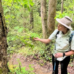
This trail did not disappoint! I love a hike with a rewarding view at the end and this hike checked that box for sure! There is a very small parking lot at the trailhead. We arrived around 8am and was the third vehicle in the lot. We did not pass anyone on the way up (except for a group camping) but it was trail was crowded on the way down around 10:30am. This trail is approximately 6 miles (total) and moderately difficult. We spent about half an hour at the top taking in the views and enjoying a snack and had the place to ourselves. Definitely recommend going early morning!

A moderately difficult trail that allows some great views when you get to the end. It's about 3 miles and 1700 ft in elevation. It was my second time hiking ever and I didn't have much issues. There was ice on some of the surfaces because of the winter weather so be careful. read more

5 years ago
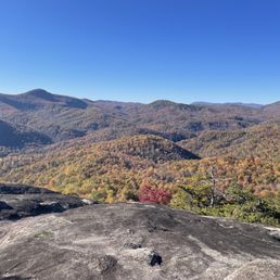
Looking Glass Rock Overlook is awesome! What makes this spot so special? 1) It is one of the best places to view LOOKING GLASS ROCK, a huge monolith that, as the Nat'l Forest Service describes: "rises from the surrounding forest like a sentinel." It is said that once upon a time, The Appalachian Mountain chain was taller than the Rockies, but the softer sandstones eroded over time leaving the harder rocks we know today. Looking Glass Rock is volcanic in nature making it harder and denser than most of the surrounding earth and did not erode as the rest of the mountain did. 2) You can also access the mountain to sea trail just across the parkway that leads to Skinny Dip Falls! If you are not in a terrible hurry, the walk to the falls should only take up about an hour of your time. Or you could spend several hours there playing in the many crystal clear pools of water along the many levels of the falls. The Parkway overlooks always give you the above sea level elevation and Looking Glass Rock Overlook is about 4,492 feet. Comparatively, the highest elevation on the parkway is Richland Balsam @ 6,053 feet, which is about 14.5 miles west of this overlook. The lowest point on the parkway is the James River Visitor Center in Virginia @ 649 feet. [ FINAL THOUGHTS ] If you haven't heard, The Blue Ridge Parkway is also known as AMERICA'S FAVORITE DRIVE. It is 469 miles long, but it won't take you even a fraction of that to see why it has this nickname. It is absolutely beautiful most times of the year but ESPECIALLY in the fall! If you are looking for a way to get out and still remain socially distanced, I can't really think of a better way than driving this amazing road. It is estimated there are 65 waterfalls just off the Parkway and hundreds more within a mile or two of the parkway. I would HIGHLY RECOMMEND visiting Lineville Falls, Mingo Falls, Crabtree Falls, Looking Glass Falls, Mount Mitchell and visiting the mile high swinging bridge @ Grandfather Mountain. AND of course Skinny Dip Falls, where the trailhead is located right here @ Looking Glass Rock Overlook. 2021 / 65 read more


3 years ago
The drive isn't too bad - less enjoyable than the Great Smokey Mountain Trail. We did see a small heard of elk on our way from Waynesville - which was pretty neat. The area is clean and pretty natural. You'll pass a small shop and and local inn on our way. read more

This trail did not disappoint! I love a hike with a rewarding view at the end and this hike checked that box for sure! There is a very small parking lot at the trailhead. We arrived around 8am and was the third vehicle in the lot. We did not pass anyone on the way up (except for a group camping) but it was trail was crowded on the way down around 10:30am. This trail is approximately 6 miles (total) and moderately difficult. We spent about half an hour at the top taking in the views and enjoying a snack and had the place to ourselves. Definitely recommend going early morning! read more


3 years ago
This place was beautiful and challenging. many people are saying it's a moderate hike, but for me this hike was challenging as heck. People i was passing of all ages and shapes were saying this is probably an extreme hike for most. The incline is super hard on the knees and isn't one to just willy nilly if your aren't already pretty fit. This hike really took me out, my knees and feet got really messed up. The views at the end were 100% worth it. It took my breathe away. read more

More info about Looking Glass Rock Overlook
Blue Ridge Pkwy
Canton, NC 28716
Directions
Visit Website
https://www.nps.gov/places/looking-glass-rock-overlook.htm
Hours
Indoor Amenities
Outdoor Amenities
Ask the Community - Looking Glass Rock Overlook


Looking Glass Rock Overlook - hiking - Updated July 2026
Best of Canton
People found Looking Glass Rock Overlook by searching for…
Trending Searches in Canton, NC
Boat Tours near Looking Glass Rock Overlook
Castles near Looking Glass Rock Overlook
Caves near Looking Glass Rock Overlook
Cliff Jumping near Looking Glass Rock Overlook
Creeks near Looking Glass Rock Overlook
Day Trips near Looking Glass Rock Overlook
Free Things To Do near Looking Glass Rock Overlook
Hidden Gems near Looking Glass Rock Overlook
Historical Sites near Looking Glass Rock Overlook
Jet Ski Rental near Looking Glass Rock Overlook
Kayak Rental near Looking Glass Rock Overlook
Kids Activities Indoor near Looking Glass Rock Overlook
Lakes near Looking Glass Rock Overlook
Landmarks & Historical Buildings near Looking Glass Rock Overlook
Off Road Trails near Looking Glass Rock Overlook
Outdoor Activities near Looking Glass Rock Overlook
Peach Picking near Looking Glass Rock Overlook
Picnic Spots near Looking Glass Rock Overlook
Places To Visit near Looking Glass Rock Overlook
Places To Walk Around near Looking Glass Rock Overlook
Public Art near Looking Glass Rock Overlook
Public Shower near Looking Glass Rock Overlook
Rainy Day Activities near Looking Glass Rock Overlook
River Swimming near Looking Glass Rock Overlook
Rock Quarry near Looking Glass Rock Overlook
Scenic Night View near Looking Glass Rock Overlook
Scenic Overlook near Looking Glass Rock Overlook
Scenic Restaurants near Looking Glass Rock Overlook
Secluded Spots near Looking Glass Rock Overlook
Small Venues & Event Spaces near Looking Glass Rock Overlook
State Parks near Looking Glass Rock Overlook
Swimming Holes near Looking Glass Rock Overlook
Swimming Lakes near Looking Glass Rock Overlook
Things To Do On A Rainy Day near Looking Glass Rock Overlook
Things To Do With Teenagers near Looking Glass Rock Overlook
Tubing near Looking Glass Rock Overlook
View Points near Looking Glass Rock Overlook
Watch Sunset near Looking Glass Rock Overlook
Browse Brands
Related Searches in Canton, NC
Affordable Kayak Rental Services in Canton, North Carolina
Affordable Paddle Board Rental in Canton, North Carolina
Best Fishing Locations and Guides in Canton, North Carolina
Best Fun Things to Do in Canton, North Carolina
Best Gym With Sauna Amenities in Canton, North Carolina
Best Gymnastics for Kids Activities in Canton, North Carolina
Best Lookout Points to Visit in Canton, North Carolina
Best Nature Trails for Hiking in Canton, North Carolina
Best Places for Calisthenics Workouts in Canton, North Carolina
Best Places for Horseback Riding in Canton, North Carolina
Best Rock Climbing Gyms to Try in Canton, North Carolina
Best Sightseeing Experiences Available in Canton, North Carolina
Best Waterfalls and Swimming Holes in Canton, North Carolina
Book Engaging Historical Tours in Canton, North Carolina
Challenge Yourself With an Obstacle Course in Canton, North Carolina
Discover Charming Historic Homes in Canton, North Carolina
Discover Dog Friendly Trails to Explore in Canton, North Carolina
Discover Famous Monuments in Canton, North Carolina
Discover Historic Sites and Places in Canton, North Carolina
Discover Kid Friendly Hiking Trails in Canton, North Carolina
Discover Kids Indoor Play Area Venues in Canton, North Carolina
Discover Lakes & Ponds to Explore in Canton, North Carolina
Discover Outdoor Gym Facilities in Canton, North Carolina
Discover Popular Bike Trails in Canton, North Carolina
Discover Popular Landmarks in Canton, North Carolina
Discover Popular Photo Spots in Canton, North Carolina
Discover Popular Ropes Course Options in Canton, North Carolina
Discover Top Points of Interest in Canton, North Carolina
Discover Top Yoga Options and Studios in Canton, North Carolina
Discover the Best Air Museum Exhibits in Canton, North Carolina
Discover the Best Interactive Museum in Canton, North Carolina
Discover the Best Military Museum in Canton, North Carolina
Discover the Best Night Hike Trails in Canton, North Carolina
Dog-Friendly Hikes With Dogs in Canton, North Carolina
Enjoy Camping Adventures Around Canton, North Carolina
Enjoy Exciting Mountain Biking Adventures in Canton, North Carolina
Enjoy Hiking Adventures in Canton, North Carolina
Enjoy Kayaking Adventures in Canton, North Carolina
Enjoy Off Leash Dog Hikes in Canton, North Carolina
Enjoy Safe and Fun Bungee Jumping in Canton, North Carolina
Enjoy Scenic Places to Walk in Canton, North Carolina
Enjoy Tent Camping Spots Around Canton, North Carolina
Enjoy a Beautiful Waterfall Hike in Canton, North Carolina
Enjoy the Best Walking Trails in Canton, North Carolina
Essential Tips for Every Tourist in Canton, North Carolina
Experience Aerial Yoga Sessions in Canton, North Carolina
Explore Beautiful Botanical Gardens in Canton, North Carolina
Browse Articles
People who viewed Looking Glass Rock Overlook also viewed
Black Balsam Knob
3 reviews
Pisgah National Forest
74 reviews
Carl Sandburg Home National Historic Site
40 reviews
Ride Kanuga
2 reviews
Moonshine Mountain Snow Tubing Park
24 reviews
Jackson County Courthouse-Historical
3 reviews
Old Flat Rock Post Office
1 review
FOX-N-OTTER Escape Rooms - Hendersonville Location
1 review
Pisgah Climbing School
1 review
Oconaluftee Islands Park
15 reviews