Cancel

    Open app

    Search

    Lower Otay Reservoir

    3.9 (11 reviews)

    Lower Otay Reservoir Photos

    You might also consider

    Recommended Reviews - Lower Otay Reservoir

    Your trust is our priority, so businesses can't pay to alter or remove their reviews. Learn more about reviews.
    Yelp app icon
    Browse more easily on the app
    Review Feed Illustration
    Photo of Kay D.
    1
    18
    43

    5 years ago

    Helpful 0
    Thanks 0
    Love this 0
    Oh no 0

    5 years ago

    Helpful 0
    Thanks 0
    Love this 0
    Oh no 0

    17 years ago

    Helpful 9
    Thanks 0
    Love this 3
    Oh no 0

    8 years ago

    Helpful 2
    Thanks 0
    Love this 2
    Oh no 0

    18 years ago

    Helpful 2
    Thanks 0
    Love this 1
    Oh no 0

    13 years ago

    Helpful 3
    Thanks 0
    Love this 0
    Oh no 0

    6 years ago

    Helpful 2
    Thanks 0
    Love this 1
    Oh no 0

    8 years ago

    Helpful 0
    Thanks 0
    Love this 0
    Oh no 0

    11 years ago

    Helpful 0
    Thanks 0
    Love this 0
    Oh no 0

    12 years ago

    Helpful 0
    Thanks 0
    Love this 0
    Oh no 0
    Photo of Jon C.
    0
    16
    0

    10 years ago

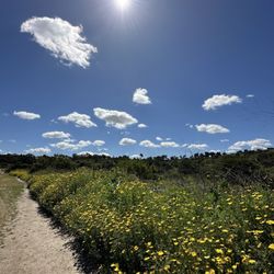
    Wonderful lake for kayaking, canoeing, or motor boats. Lots of big fish were being caught. Lots of picnic facilities.
    Helpful 1
    Thanks 0
    Love this 0
    Oh no 0

    Ask the Community - Lower Otay Reservoir

    You might also consider

    Verify this business for free

    People searched for Lakes 924 times last month within 15 miles of this business.

    Verify this business

    Eastlake Lake

    Eastlake Lake

    4.2(37 reviews)
    4.4 mi

    Beautiful lake! I love all the ducks and turtles that have made this lake their home…read more There's a nice path around this lake. Easily walkable and accessible to families with strollers. Super quiet and peaceful. It's perfect to take a stroll and enjoy nature while getting some vitamin d. There's a lot of benches and grassy areas too.

    At this point, I think residents have every right to start demanding answers…read more This community used to be absolutely beautiful. It was clean, maintained, and a place you could genuinely be proud to call home. Today, September 21, 2026, some of these areas look and smell completely unacceptable. The Beach Club area has turned green, ducks and geese are constantly swimming in it, there is an extremely unpleasant odor, and the overall condition looks neglected. These are amenities that residents pay substantial HOA fees every single year to maintain and enjoy. So I think the questions need to be asked directly: Where are our HOA dues going? Who is responsible for inspecting and maintaining these areas? When were these areas last properly serviced? What is management doing about the current conditions, and when can residents expect them to be corrected? I'm tired of watching the condition of this community decline while residents continue paying their fees as expected. If residents are required to meet their financial obligations to the HOA, then the HOA and its management company should be expected to meet their obligations to the residents as well. And considering the letter that has recently been delivered to residents regarding issues involving the HOA, I believe transparency is more important now than ever. Residents deserve more than vague explanations. We deserve a clear response, a corrective maintenance plan, a timeline for completion, and transparency regarding how our HOA dues are being used. If there are financial problems, staffing problems, management problems, maintenance problems, or something else preventing these areas from being properly maintained, then communicate that to the homeowners and residents. Staying silent while the property continues deteriorating is not acceptable. This is not about attacking anyone personally. This is about accountability. This community was beautiful when I came here, and residents should not have to sit quietly and watch it deteriorate. We pay too much money for that. Enough excuses and enough neglect. Address the problem, communicate with the residents, and restore this community to the condition we are paying for. In

    Photos
    Eastlake Lake
    Eastlake Lake
    Eastlake Lake

    See all

    Otay Lakes County Park

    Otay Lakes County Park

    4.5(37 reviews)
    2.3 mi

    We booked space #1 for our baby shower and it was the best choice. It allowed up to 100 people with…read morevery minimal restrictions and it cost less than $250 for the whole day! The space overlooks the water and is the first space you'll see driving up. It's a bit secluded from the rest of the park allowing you to have a more private event with your guests. We ended up having just 40 people attend our baby shower, but with the ample space, it allowed us to fully decorate the space and bring separate tables for desserts and welcome table. The stage space was perfect for the photo backdrop and everything came out so beautifully. Highly recommend this space for any events, even a small outdoor wedding. Check-in was super easy and we were allowed music, decors, and even alcohol on site. Some of us came an hour early to start the decorations and stayed an hour later to clean up, but you can access your space anytime between 9-5:30pm. Everything was perfect. Our event was only 4 hours so it was more than enough time to come early to set up and fully clean up after. Restrooms are super clean, park is well maintained with rangers on-site. Parking is $5 all day and plenty of our things for guests to do such as playground for the kids or the open grass area to run around in or nice hiking trails all around for a quick exploring.

    My niece has here bridal shower here and it was beautiful out there. The grounds are well kept, it…read moreis about a mile off the main road. You do have to pay $5 to park.

    Photos
    Otay Lakes County Park
    Otay Lakes County Park
    Otay Lakes County Park

    See all

    Sweetwater Summit Regional Park - View from our camp spot

    Sweetwater Summit Regional Park

    3.9(55 reviews)
    6.9 mi

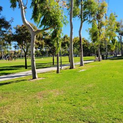
    Coming to this location for a family hike was a great decision. We have had a very trial ridden…read morepast three weeks and we needed some time to get away for a special hike. When you approach this area, you can easily be misdirected to the county regional park. To avoid this before you go up the hill to the entrance of the county regional park make a right into the driveway that shows the Sweetwater Reservoir. Once you get in there, you will go along a long dirt road to a parking lot that is eventually located next to the Reservoir fishing area. It is a beautiful trail and it's wonderful to be able to walk around the water and see ducks and birds and other wildlife as well as beautiful plants like Manzanita and chaparral. It is a wonderful trail hike, with beautiful and refreshing wind and sunshine. They have Porta potties that are super clean and well-maintained. I would say the porta potties are about a half a mile apart. They also have a bench with an overlook platform along the trail, and everything that we encountered seem to be very clean and well maintained. We will definitely visit this place again and it is definitely a wonderful place to hike. We were able to get out and started to explore the trail and after about 15 minutes, we realized that there was a Ranger honking at us with his siren coming around the bend. He made his way up to us in his truck and indicated that he would be closing the gate to the park in the next five minutes. We told him that we were told by the Park Ranger at the SD County Park check in booth that this trail closes at 8 PM tonight. He then said that we were not the only family to tell him that but that the Sweetwater Reservoir Trail Park actually closes at 5 PM because it's not a part of the SD County Regional Parks; they close at 8p. We rushed back to our vehicle, which was about a mile and a half away and we were able to get in and leave. We were very lucky that this Park Ranger decided to wait for us because we would've been locked into four or five gates and not able to actually get out of the park, even to get an Uber. This was great to understand and know so that when we go next time, we'll go a lot earlier before 5 PM.

    I was in the Bonita community earlier this summer and wanted to do a medium length hike, A search…read moreresult came back with this trail at the Sweetwater Summit Regional Park. The staff member at the guard station indicated that I could use the day lot to park my vehicle since I was only hiking and not camping on the grounds. The path was pretty well maintained, but it also doubled as a horseback riding trail so occasionally one would have to dodge the mounds of dung left behind. Sweetwater Reservoir was off to the north of the trail. That body of water gave a nice scenic backdrop. The trek was up and down the foothills before looping back towards the start for a total of just over five miles. I expected to see more mountain bikers because the contours and breaks were conducive for that type of cycling without being too strenuous. There was no shade except for a hut at the peak of the hike. Sunscreen, sunglasses, a hat, and plenty of water were a must during the daytime. I would rate this hike as moderate because there were a couple of spots where the ascent did make one breathe much harder than usual. My overall rating for this trek was between three and four stars.
    Photos
    Sweetwater Summit Regional Park - Beautiful

    Beautiful

    Sweetwater Summit Regional Park - Sunset at my safe haven.

    Sunset at my safe haven.

    Sweetwater Summit Regional Park

    See all

    Lake Murray - Always gorgeous

    Lake Murray

    4.4(336 reviews)
    13.1 mi

    Lake Murray is so beautiful and I enjoy coming here! I've been here a few times to walk the trail…read moreand also sit by the lake and read on a nice sunny morning. The birds can be a bit annoying, but guess that comes with the great outdoors. Definitely a nice spot to chill, take a walk and get those steps in. This area feels safe and well maintained. When I went, there weren't too many people, so it was pretty peaceful. The trail can get busy and there are bathrooms along the way (I didn't use them though) There's plenty of parking here, but just be sure you leave on time for closing. I've heard they lock up and it can be an issue with getting out. (not sure how true this is but I won't chance it) There is more parking elsewhere with trail access too, I just personally haven't found it.

    Lake Murray Service road walking trail is one of my go-to workouts--about 5.5 miles to the locked…read moregate and back. After entering the main entrance, follow the road and turn right where you will see a yellow locked gate. This is the beginning of the paved walking trail. There's plenty of parking at the main entrance, and the paved trail is perfect for walkers, runners, bikers, and even kids tagging along. It's basically a choose-your-own-adventure: bird watching, fishing (permit required), or just a casual picnic. Bonus perks: lots of porta potties and benches when you need a breather. If you're holding out for a real restroom, there's one just past the second baseball field--plan accordingly. Photo is attached to show where to locate this. Heads up: the main gate is closed every 2nd Tuesday of the month, but don't panic--you can still access the trail through the neighborhood entrance off Baltimore Drive. Hope you enjoy this walking trail as much as I do.

    Photos
    Lake Murray - Bench for a picnic. Be careful it maybe too hot out!

    Bench for a picnic. Be careful it maybe too hot out!

    Lake Murray - Read signs and be careful when wondering off the paved road.

    Read signs and be careful when wondering off the paved road.

    Lake Murray

    See all

    Otay Valley Regional Park - Map of the 8mi route. We started on the Hollister St said. Don't do that

    Otay Valley Regional Park

    3.6(21 reviews)
    10.1 mi•Otay

    I feel bad about leaving negative feedback on a FREE park, of all things. But I felt that the space…read morewas unsafe and dirty, so based on my recent impressions, I don't recommend this hike. We arrived before 8AM so the parking lots at the staging areas still had their gates closed. We parked on Hollister, around a block before Main. It did not look like there were any parking restrictions. So we started the hike on the western side of the park, which based on prior Yelp reviews, probably is not the best area to hike. As we progressed through the hike, we headed past multiple tents (unclear if seeing a portion of a homeless encampment or just scattered tents). We got startled by someone who seemed to materialize suddenly outside a tent into the trail. But what made us leave the area was an individual who was yelling angrily and cursing heading toward us. Maybe he was just not a morning person, but we clearly couldn't go any further. Other issues: Each dog we came across was an unleashed dog. The owners would be far behind, so the first two times, I thought they were wild dogs and was not certain of their friendliness. As an avid hiker, this does not seem to be the usual hiking etiquette. Trail is clearly demarcated and paved, but it seemed to have squashed piles of poo versus mud. Initially we went in the wrong direction and went under a dark bridge (see photo, which makes it look less ominous than it actually was). I think this direction actually does take people on a specific trail, but this one was not part of the 8mi out-and-back hike we were planning. If you end up here, you likely took a wrong turn. As we walked, I felt that the park smelled like eucalyptus mixed with something not so pleasant. Not sure what it was, but we had to switch frequently to mouth -breathing, which is not a typical problem I have during hikes. It was meant to be an 8mi hike but we turned back early because we did not feel very comfortable after being possibly chased so ended up just completing 1.6mi. Again, I hate to criticize parks, especially such a large natural space in a sea of urbanity. But this was not a fun hike, and I will never return unless the area becomes less unwelcoming.

    I have walked the full length of this park, and now I understand the mixed reviews. It is an urban…read morepark with the good, bad, and the ugly. If you are near Chula Vista, it is great having a nature trail within a few miles from Downtown CV. First of all, it's a misnomer to call it a park. It is a four mile hiking path, so expect to walk eight miles if you want to do the full length since it is one way. Its endpoints are near Highway 5 and 805. The western canyon section is my favorite. You walk parallel to the river with a view of Otay Mountain in the distance. It has dense fauna so you forget about the houses above you and the glimpses of the main road. The trail is not well marked, but it is pretty straight and level so you can't really get lost. On the western portion there are paths that crisscross. The fire utility access road on a higher plain, the "main" path, and a segway closer to the river. It is mixed surfaces varying between sandy loam, gravel, and small loss rock. You can make it with sneakers, but I prefer hiking boots . In contrast, the western portion is a bit like an apocalyptic movie set. Personally I wouldn't go pass Fenton Pond. As I reached towards the Imperial Beach border, there were underpass sections with some sketchy folks. I came across a few tents and a zombie like woman with her long hair covering her face. The path shares a section with Bella Terra nursery, which makes spruces up the barren landscape but there was an overwhelming smell of fertilizer. There is a constant hum of traffic and the nearby trolley. Since it is near urban centers, you will find graffiti and garbage anywhere by main roads. There are multiple entry points, but unless you are local they are not easy to find. I recommend starting at the ranger station on Beyer Blvd. with a parking lot and good signage. If you are within thirty minute drive, I would recommend visiting this "park." My last tip is to cross the street from the parking lot in lieu of looping around the underpass.

    Photos
    Otay Valley Regional Park
    Otay Valley Regional Park
    Otay Valley Regional Park

    See all

    Lower Otay Reservoir - lakes - Updated September 2026

    Loading...
    Loading...
    Loading...