Lytle Creek - Cajon Pass Recreation Area Photos


You might also consider
More like Lytle Creek - Cajon Pass Recreation Area
Recommended Reviews - Lytle Creek - Cajon Pass Recreation Area
Start your review...

10 months ago
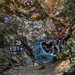
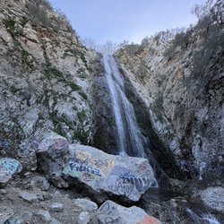
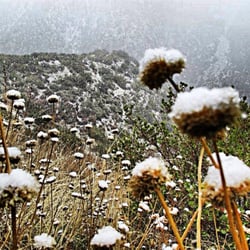
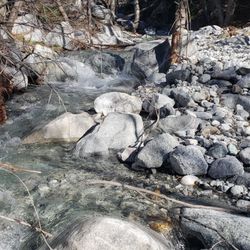
Here on 8/2025 ‼BRING PLENTY OF TRASH BAGS PLEASE This place is a true experience in the forest close to the city. There's no charge at all A huge river stretch for lots of people to enjoy There is some spots that has a dirty smell in the air due to poor trash pick up. Water can be cold. Pools of river in random parts. Lots of tagging on rocks. Water shoes at all times. The Bonita Waterfalls is in the area. read more


7 months ago
More info about Lytle Creek - Cajon Pass Recreation Area
You might also consider


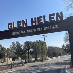


Lytle Creek - Cajon Pass Recreation Area - hiking - Updated July 2026
Best of Lytle Creek
People found Lytle Creek - Cajon Pass Recreation Area by searching for…
Fun Things to Do in Lytle Creek, California
Hiking Trails in Lytle Creek, California
Waterfall Hike in Lytle Creek, California
Free Things to Do in Lytle Creek, California
Gold Panning in Lytle Creek, California
Walking Trails in Lytle Creek, California
Swimming Lakes in Lytle Creek, California
Secluded Spots in Lytle Creek, California
Redwood Forest in Lytle Creek, California
Running Trails in Lytle Creek, California
Scenic Views in Lytle Creek, California
Trails in Lytle Creek, California
Lakes & Ponds in Lytle Creek, California
Picnic Areas in Lytle Creek, California
Creeks in Lytle Creek, California
Secret Spots in Lytle Creek, California
Easy Hikes in Lytle Creek, California
Places to Walk at Night in Lytle Creek, California
Places to Take Pictures in Lytle Creek, California
Empty Parking Lot in Lytle Creek, California
Fun Places in Lytle Creek, California
Tent Camping in Lytle Creek, California
Trending Searches in Lytle Creek, CA
Black Owned Nail Salons near Lytle Creek - Cajon Pass Recreation Area
Boat Rental near Lytle Creek - Cajon Pass Recreation Area
Cliff Jumping near Lytle Creek - Cajon Pass Recreation Area
Day Trips near Lytle Creek - Cajon Pass Recreation Area
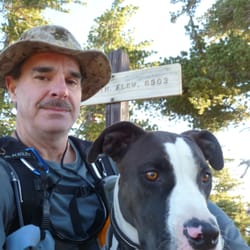
Dog Friendly Trails near Lytle Creek - Cajon Pass Recreation Area
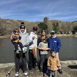
Fishing Spots near Lytle Creek - Cajon Pass Recreation Area
Jet Ski Rental near Lytle Creek - Cajon Pass Recreation Area
Kayak Rental near Lytle Creek - Cajon Pass Recreation Area
Lakes near Lytle Creek - Cajon Pass Recreation Area
Off Road Trails near Lytle Creek - Cajon Pass Recreation Area
Outdoor Activities near Lytle Creek - Cajon Pass Recreation Area
Places To Walk Around near Lytle Creek - Cajon Pass Recreation Area
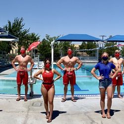
Pool Day Pass near Lytle Creek - Cajon Pass Recreation Area
Public Pools near Lytle Creek - Cajon Pass Recreation Area
Public Shower near Lytle Creek - Cajon Pass Recreation Area
River Swimming near Lytle Creek - Cajon Pass Recreation Area
Rock Quarry near Lytle Creek - Cajon Pass Recreation Area
Running Trails near Lytle Creek - Cajon Pass Recreation Area
Scenic Night View near Lytle Creek - Cajon Pass Recreation Area
Scenic Overlook near Lytle Creek - Cajon Pass Recreation Area
Secluded Spots near Lytle Creek - Cajon Pass Recreation Area
Soccer Store near Lytle Creek - Cajon Pass Recreation Area
Splash Pad near Lytle Creek - Cajon Pass Recreation Area
Strawberry Picking near Lytle Creek - Cajon Pass Recreation Area
Sunrise View near Lytle Creek - Cajon Pass Recreation Area
Swimming Holes near Lytle Creek - Cajon Pass Recreation Area
Swimming Lakes near Lytle Creek - Cajon Pass Recreation Area
Browse Articles
Browse Nearby
BEST of Lytle Creek, California Restaurants near Lytle Creek - Cajon Pass Recreation Area
BEST of Lytle Creek, California Coffee near Lytle Creek - Cajon Pass Recreation Area
BEST of Lytle Creek, California Things to Do near Lytle Creek - Cajon Pass Recreation Area
BEST of Lytle Creek, California Breakfast near Lytle Creek - Cajon Pass Recreation Area
BEST of Lytle Creek, California Campgrounds near Lytle Creek - Cajon Pass Recreation Area
BEST of Lytle Creek, California Thrift Stores near Lytle Creek - Cajon Pass Recreation Area
BEST of Lytle Creek, California Gym near Lytle Creek - Cajon Pass Recreation Area
Browse Brands
Related Searches in Lytle Creek, CA
Best Fishing Locations and Guides in Lytle Creek, California
Best Fun Things to Do in Lytle Creek, California
Best Nature Trails for Hiking in Lytle Creek, California
Best Places for Horseback Riding in Lytle Creek, California
Best Sledding Spots and Fun in Lytle Creek, California
Best Spots for Star Gazing in Lytle Creek, California
Best Waterfalls and Swimming Holes in Lytle Creek, California
Check Out Off Road Trails in Lytle Creek, California
Discover Dog Friendly Trails to Explore in Lytle Creek, California
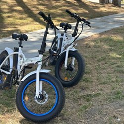
Discover Popular Bike Trails in Lytle Creek, California
Discover Popular Photo Spots in Lytle Creek, California
Discover a Hiking Trail in Lytle Creek, California
Discover the Best Night Hike Trails in Lytle Creek, California
Dog-Friendly Hikes With Dogs in Lytle Creek, California
Enjoy Camping Adventures Around Lytle Creek, California
Enjoy Scenic Night View Experiences in Lytle Creek, California
Enjoy Tent Camping Spots Around Lytle Creek, California
Enjoy a Beautiful Waterfall Hike in Lytle Creek, California
Enjoy the Best Picnic Spots and Ideas in Lytle Creek, California
Enjoy the Best Walking Trails in Lytle Creek, California
Exciting Cliff Jumping Spots in Lytle Creek, California
Explore Beautiful Parks and Green Spaces in Lytle Creek, California
Explore Easy Hikes Perfect for All in Lytle Creek, California
Explore Popular Campgrounds Near Lytle Creek, California
Explore Popular RV Parks Around Lytle Creek, California
Explore Popular Scenic Overlook Points in Lytle Creek, California
Explore Scenic Lakes to Visit in Lytle Creek, California
Explore Secret Spots Worth Visiting in Lytle Creek, California
Explore the Best Swimming Holes Around Lytle Creek, California
Explore the Best Trail Options in Lytle Creek, California
Family Friendly Hiking With Kids in Lytle Creek, California
Find Popular Ziplining Spots Around Lytle Creek, California
Find Top Skate Parks in Lytle Creek, California for All Skill Levels
Find the Best Swimming Pools in Lytle Creek, California Today
Have Fun at a Splash Pad in Lytle Creek, California
Hiking Trails With Waterfalls in Lytle Creek, California
Off Leash Dog Hiking Trails in Lytle Creek, California
Perfect Spots to Watch Sunset in Lytle Creek, California
Picnic Areas With BBQ Pits Available in Lytle Creek, California
Plan a Scenic Drive Route Near Lytle Creek, California
Popular Fishing Spots to Explore in Lytle Creek, California
Popular Kids Activities in Lytle Creek, California
Popular Picnic Spots to Visit in Lytle Creek, California
Popular Places to Take Pictures in Lytle Creek, California
Popular Things to Do in Lytle Creek, California
Relax at Natural Hot Springs Near Lytle Creek, California
Safe River Swimming Areas in Lytle Creek, California
Safe and Fun Parks for Kids in Lytle Creek, California
People who viewed Lytle Creek - Cajon Pass Recreation Area also viewed
Lytle Creek Ranger Station
39 reviews
Old Mt. Baldy Trail
29 reviews
Applewhite Picnic Area
9 reviews
Ontario Peak
22 reviews
Devil's Backbone
63 reviews
Day Creek Canyon
1 review
San Antonio Falls Trailhead
1 review
Mormon Rocks Interpretive Trail
8 reviews
Pacific Electric Trail
19 reviews
Bridge to Nowhere
5 reviews