Day Creek Canyon Photos


You might also consider
More like Day Creek Canyon
Recommended Reviews - Day Creek Canyon
Start your review...

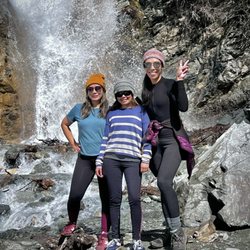
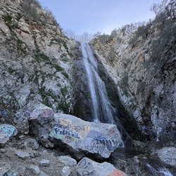
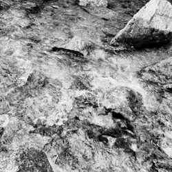
From the same parking lot for Etiwanda reserve, you go way left on to a gravel road tall grass area with some places that are heavy woods. It is slightly higher than trail to Etiwanda and the trails for this area has a dead end. I someone who knows the trail or looks for maps. I could not find any website to this trailwas told that the water flows spring and when it rains. So its seasonal. Make sure you go with someone who knows the trail or looks for maps. I could not find any website to this trail nor the day creek area. The parking is free but small... read more


More info about Day Creek Canyon
4800 Etiwanda Ave
Rancho Cucamonga, CA 91739
Directions
Hours
Outdoor Amenities
You might also consider


Day Creek Canyon - hiking - Updated July 2026
Best of Rancho Cucamonga
People found Day Creek Canyon by searching for…
Hiking Trails in Rancho Cucamonga, California
Walking Trails in Rancho Cucamonga, California
Free Things to Do in Rancho Cucamonga, California
Creeks in Rancho Cucamonga, California
Trails in Rancho Cucamonga, California
Empty Parking Lot in Rancho Cucamonga, California
Running Trails in Rancho Cucamonga, California
Waterfall in Rancho Cucamonga, California
Sunday Fun Things to Do in Rancho Cucamonga, California
Forest in Rancho Cucamonga, California
Nature Parks in Rancho Cucamonga, California
Free Parking in Rancho Cucamonga, California
Park & Forests in Rancho Cucamonga, California
Places to Walk at Night in Rancho Cucamonga, California
Off Road Trails in Rancho Cucamonga, California
Walking Groups in Rancho Cucamonga, California
Places to Take Pictures in Rancho Cucamonga, California
Things to Do Alone in Rancho Cucamonga, California
Fall Foliage in Rancho Cucamonga, California
Attractions in Rancho Cucamonga, California
Scenic Views in Rancho Cucamonga, California
Photo Spots in Rancho Cucamonga, California
Trending Searches in Rancho Cucamonga, CA
4th Of July Fireworks in Rancho Cucamonga, CA
Black Owned Nail Salons in Rancho Cucamonga, CA
Boat Rental in Rancho Cucamonga, CA
Cliff Jumping in Rancho Cucamonga, CA
Day Trips in Rancho Cucamonga, CA
Dog Friendly Trails in Rancho Cucamonga, CA
Fireworks in Rancho Cucamonga, CA
Jet Ski Rental in Rancho Cucamonga, CA
Kayak Rental in Rancho Cucamonga, CA
Lakes & Ponds in Rancho Cucamonga, CA
Outdoor Activities in Rancho Cucamonga, CA
Places To Walk Around in Rancho Cucamonga, CA
Public Pools in Rancho Cucamonga, CA
Public Shower in Rancho Cucamonga, CA
Rock Quarry in Rancho Cucamonga, CA
Running Trails in Rancho Cucamonga, CA
Scenic Night View in Rancho Cucamonga, CA
Scenic Overlook in Rancho Cucamonga, CA
Secluded Spots in Rancho Cucamonga, CA
Soccer Store in Rancho Cucamonga, CA
Splash Pad in Rancho Cucamonga, CA
Strawberry Picking in Rancho Cucamonga, CA
Sunrise View in Rancho Cucamonga, CA
Swimming Holes in Rancho Cucamonga, CA
Swimming Lakes in Rancho Cucamonga, CA
Swimming Pools in Rancho Cucamonga, CA
Watch Sunset in Rancho Cucamonga, CA
Browse Articles
Browse Nearby
BEST of Rancho Cucamonga, California Coffee near Day Creek Canyon
BEST of Rancho Cucamonga, California Things to Do near Day Creek Canyon
BEST of Rancho Cucamonga, California Restaurants near Day Creek Canyon
BEST of Rancho Cucamonga, California Parks near Day Creek Canyon
BEST of Rancho Cucamonga, California Walking Trails near Day Creek Canyon
BEST of Rancho Cucamonga, California Breakfast near Day Creek Canyon
BEST of Rancho Cucamonga, California Campgrounds near Day Creek Canyon
BEST of Rancho Cucamonga, California Motel near Day Creek Canyon
Browse Brands
Related Searches in Rancho Cucamonga, CA
Best Fishing Locations and Guides in Rancho Cucamonga, California
Best Nature Trails for Hiking in Rancho Cucamonga, California
Best Places for Horseback Riding in Rancho Cucamonga, California
Best Sledding Spots and Fun in Rancho Cucamonga, California
Best Waterfalls and Swimming Holes in Rancho Cucamonga, California
Check Out Off Road Trails in Rancho Cucamonga, California
Discover Dog Friendly Trails to Explore in Rancho Cucamonga, California
Discover Kid Friendly Hiking Trails in Rancho Cucamonga, California
Discover Scenic Mountain Bike Trails Near Rancho Cucamonga, California
Discover Scenic Waterfall Spots in Rancho Cucamonga, California
Discover Top Nature Parks to Visit in Rancho Cucamonga, California
Discover a Hiking Trail in Rancho Cucamonga, California
Discover the Best Night Hike Trails in Rancho Cucamonga, California
Dog-Friendly Hikes With Dogs in Rancho Cucamonga, California
Enjoy Camping Adventures Around Rancho Cucamonga, California
Enjoy Exciting Mountain Biking Adventures in Rancho Cucamonga, California
Enjoy Kayaking Adventures in Rancho Cucamonga, California
Enjoy Tent Camping Spots Around Rancho Cucamonga, California
Enjoy a Beautiful Waterfall Hike in Rancho Cucamonga, California
Enjoy a Peaceful Nature Walk in Rancho Cucamonga, California
Enjoy the Best Picnic Spots and Ideas in Rancho Cucamonga, California
Enjoy the Best Tubing Experiences in Rancho Cucamonga, California
Enjoy the Best Walking Path in Rancho Cucamonga, California
Enjoy the Best Walking Trails in Rancho Cucamonga, California
Exciting Cliff Jumping Spots in Rancho Cucamonga, California
Explore Beautiful Parks and Green Spaces in Rancho Cucamonga, California
Explore Easy Hikes Perfect for All in Rancho Cucamonga, California
Explore Fun Activities to Do in Rancho Cucamonga, California
Explore Popular Campgrounds Near Rancho Cucamonga, California
Explore Top Dog Parks in Rancho Cucamonga, California Near You
Explore the Best Trail Options in Rancho Cucamonga, California
Family Friendly Hiking With Kids in Rancho Cucamonga, California
Find Beautiful Views in Rancho Cucamonga, California
Find Popular Ziplining Spots Around Rancho Cucamonga, California
Find the Best Parks for Picnics in Rancho Cucamonga, California
Great Places to Walk in Rancho Cucamonga, California
Hike the Popular Waterfall Trail in Rancho Cucamonga, California
Hiking Trails With Waterfalls in Rancho Cucamonga, California
Off Leash Dog Hiking Trails in Rancho Cucamonga, California
Plan a Scenic Drive Route Near Rancho Cucamonga, California
Popular Outdoor Activities to Try in Rancho Cucamonga, California
Popular Picnic Spots to Visit in Rancho Cucamonga, California
Safe River Swimming Areas in Rancho Cucamonga, California
Safe and Fun Parks for Kids in Rancho Cucamonga, California
Top Climbing Spots and Gyms in Rancho Cucamonga, California
Top Running Trails to Explore in Rancho Cucamonga, California
Top Swimming Lakes to Enjoy in Rancho Cucamonga, California
Top Swimming Spots and Pools in Rancho Cucamonga, California
Walk Dog Friendly Hiking Trails in Rancho Cucamonga, California
Walk the Best Paved Walking Trails in Rancho Cucamonga, California
People who viewed Day Creek Canyon also viewed
North Etiwanda Preserve
306 reviews
Etiwanda Falls Trail
58 reviews
Cucamonga Peak
109 reviews
Pacific Electric Inland Empire Trail
73 reviews
Pacific Electric Trail - Route 66 Trailhead
4 reviews
Bridle Path
24 reviews
Demens Creek Trail
2 reviews
Lytle Creek - Cajon Pass Recreation Area
3 reviews
San Antonio Falls
66 reviews
Jurupa Hills North Trail
1 review