Mill Shoals and Big Shoals Falls Photos


More like Mill Shoals and Big Shoals Falls
Recommended Reviews - Mill Shoals and Big Shoals Falls
Start your review...

6 years ago
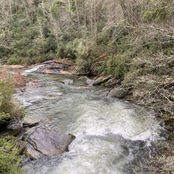
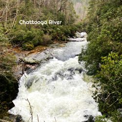
COVID-19 has done a number on my body! I've gained a lot of corona-pounds over the last few months and decided it's time to get back to doing what I love to do, hiking! I'm much happier burning calories in the woods than I am in the gym! One thing I've noticed for certain as a direct result of COVID-19, hiking trails are a lot more populated now than in the past. I used to be able to hike to North Georgia waterfalls in relative peace prior to lockdowns and social distancing protocols. NOW, everyone and their gosh dang mama are on the trails... which has forced me to look for more off the beaten path activities! Well, I found the website of a guy who does the type of hiking I've always wanted to do! His name is Mark Oleg and in many of his hiking reports, he machetes' his way to waterfalls that have no official trail + gives full GPS coordinates of his routes as well as helpful tips & elevation gain expectations! My first official test of his directions was at Sarah's Creek back in March. I convinced my hiking buddy Jamarcus it would be a fun adventure to try roads-less-travelled and he regrettably agreed! Jamarcus doesn't like to get his feet wet you see, and Sarah's Creek was a wet hike! Fast forward 7 months and I get a call from Jamarcus asking if I wanted to go hiking! Mill Shoals & Big Shoals have been on my bucket list for almost a year, so yet again I convinced him to give another offbeat trail a try! Thank God he has a short memory... LOL! HERE ARE THE DETAILS: ~ THE EXPERIENCE We set our navigation to Wolf Creek Church Road, when I used a map I predownloaded from Mark Oleg website. I CAN NOT STRESS ENOUGH these are not hikes for beginners or even casual hikers. You MUST download directions and maps to your phone prior to getting in your car to drive. I would also recommend studying the directions/notes prior, because you will feel much better studying them at home than on the trail! *** HIKING DIRECTIONS: Approximately 0.8 miles past Wolf Creek Church you will see a dirt road fork off to your left. Take it approx. 735 feet to a small gate & turnaround where there is a niche for about 2 cars. Once parked, walk around the gate down the old forest service road. The road is easy to follow! However, when you come to a fork, stay to the right. Next you will come to a clearing where the road will soon get narrower and curve left. This is where the elevation will begin to rapidly descend to Stekoa Creek. The closer you get to the creek, the steeper the decline, but doable for most people in decent shape. The return trip back however will be a calorie burner! Once you reach the creek, you will easily hear Mill Shoals Falls [approx. 18' tall]. You will need to climb over a large downed tree and navigate your way as best you can to the falls. The pools of water around the falls appear to be fairly deep, at least 7' or better. But Stekoa Creek is known to not have the cleanest water, so a swim would probably not be wise. You can either follow your path back out or attempt to reach larger Big Shoals Falls further upstream. I've included the map I used from Mark's website, but I warn you, it is not easy to follow. The trek to Big Shoals requires a steep uphill, then downhill climb with ABSOLUTELY NO PATH to guide you! The map also navigates you around a parcel of land marked private property, although there is nothing on it. Jamarcus decided to forego the hike to Big Shoals Falls [approx. 30' tall] and waited near Mill Shoals as I made my attempt. It was difficult, but I trusted the map and my ears to guide me to the falls. I emerged back where Jamarcus was waiting, scarred from fighting through forest growth and heavily sweating but satisfied at my conquest! ~ FINAL THOUGHTS READ THIS REVIEW thoroughly and try to visit Mark's website before attempting to hike to these falls, and please don't go alone! It's a great adventure for the daring, but don't be stupid! This trail is best hiked with a companion if for no other reason but for help in case of an injury. I would also recommend telling a family member or friend your hiking plans just in case. I seriously doubt this trail gets many visitors (we saw no one), so a bad injury could leave you stranded for days without help. ENJOY! LENGTH: 3.2 miles round trip DIFFICULTY: 3 out of 10 to Mill Shoals / 6 out of 10 to Big Shoals ELEVATION GAIN: 795+ feet WATERFALL ATTRACTIVENESS: 6 / 8 2020 / 78 read more


5 years ago
very nice! Mill Shoals and Big Shoals falls were the hiking destination for one of my rare days off during the height of Covid times. This hike was way back in October 2020, but i'm just now posting it (sorry, my reviews have been behind!). At any rate, I had a day, needed to get outdoors and Richard had these hikes in mind and wanted to check them both out. The Trail is easy to miss. We drove right past it, back tracked, and then found the small dirt road fork that was found on the left. When I say small dirt road, again, you're not sure if that's the path. Keep an eye on your mileage because it's just shy of a mile past the wolf creek church. We parked in a small opening and the trail becomes a bit more easy to follow here. Note, very early in the trail you'll see a small yellow sign nailed to a tree. This is not the path to the trail. The trail continues to the right of that sign. You should continue to descend down in what seems to be a gradual decline at first. This is tougher to get out of on the way back, so make sure you can handle getting out of this place! You'll hear the waterfall before you see it, but ultimately you're gonna find sandy areas past a few downed trees and plants that were pushed in what appears to be the water from the falls when the waters were really flowing. If you don't appreciate the power of this thing, seeing Mill shoals off in the distance should change your mind. Not the tallest waterfall, but it was full when we went, and it is possible to get yourself around these areas without getting your feet wet. It just requires a few hops and path choices! From here, that's where my experience ends. Richard and I did go up a steep incline to search for Big shoals falls. For one of my first hikes in months, I could tell I was running on fumes and wouldn't make it out if I continued to search anymore for Big Shoals, so I sat and waited for Richard to return. Just a note that if you're not still bursting with energy at this point and don't have the stamina, getting to Big Shoals is a challenge that can wipe you out....and there's the point of getting back out of the trail altogether. End of the day, I really enjoyed the hike, the waterfalls, and while this did turn into the first hike that I did not finish from start to finish, I still was able to enjoy a great waterfall, and maybe in a few months i'll be able to head back and finish this trail off! This is an isolated trail. I wouldn't recommend doing it alone, nor would I recommend doing it if you're not prepared for a hike that can and will challenge you. From what I can tell, this is a pet friendly hike, at least until you reach Mill shoals falls. Have fun! read more


More info about Mill Shoals and Big Shoals Falls
Wolf Creek Church Rd
Tiger, GA 30576
Directions
Hours
Outdoor Amenities


Mill Shoals and Big Shoals Falls - hiking - Updated July 2026
Best of Tiger
People found Mill Shoals and Big Shoals Falls by searching for…
Hiking Trails With Waterfalls in Tiger, Georgia
Secret Spots in Tiger, Georgia
Off Road Trails in Tiger, Georgia
Waterfalls and Swimming Holes in Tiger, Georgia
Things to Do in Tiger, Georgia
Scenic Overlook in Tiger, Georgia
Places to Take Pictures in Tiger, Georgia
Scenic Drive in Tiger, Georgia
Running Trails in Tiger, Georgia
Secluded Spots in Tiger, Georgia
Historical Tours in Tiger, Georgia
Historical Sites in Tiger, Georgia
Walking Trails in Tiger, Georgia
Study Places in Tiger, Georgia
Things to See in Tiger, Georgia
Trending Searches in Tiger, GA
Black Owned Nail Salons near Mill Shoals and Big Shoals Falls
Boat Rental near Mill Shoals and Big Shoals Falls
Cliff Jumping near Mill Shoals and Big Shoals Falls
Day Trips near Mill Shoals and Big Shoals Falls
Fireworks near Mill Shoals and Big Shoals Falls
Hiking near Mill Shoals and Big Shoals Falls
Kayak Rental near Mill Shoals and Big Shoals Falls
Landmarks & Historical Buildings near Mill Shoals and Big Shoals Falls
Peach Picking near Mill Shoals and Big Shoals Falls
Places To Swim near Mill Shoals and Big Shoals Falls
Public Pools near Mill Shoals and Big Shoals Falls
Public Shower near Mill Shoals and Big Shoals Falls
River Swimming near Mill Shoals and Big Shoals Falls
Rock Quarry near Mill Shoals and Big Shoals Falls
Scenic Drive near Mill Shoals and Big Shoals Falls
Scenic Overlook near Mill Shoals and Big Shoals Falls
Splash Pad near Mill Shoals and Big Shoals Falls
Strawberry Picking near Mill Shoals and Big Shoals Falls
Swimming Holes near Mill Shoals and Big Shoals Falls
Swimming Lakes near Mill Shoals and Big Shoals Falls
Watch Sunset near Mill Shoals and Big Shoals Falls
Browse Articles
Browse Brands
Related Searches in Tiger, GA
Affordable Kayak Rental Services in Tiger, Georgia
Best Fishing Locations and Guides in Tiger, Georgia
Best Lookout Points to Visit in Tiger, Georgia
Best Observation Deck Views in Tiger, Georgia
Best Places for Horseback Riding in Tiger, Georgia
Best Spots for Star Gazing in Tiger, Georgia
Best Things to Do on a Rainy Day in Tiger, Georgia
Best Waterfalls and Swimming Holes in Tiger, Georgia
Check Out Off Road Trails in Tiger, Georgia
Discover Charming Historic Homes in Tiger, Georgia
Discover Dog Friendly Trails to Explore in Tiger, Georgia
Discover Fun Things to Do Alone in Tiger, Georgia
Discover Historic Sites and Places in Tiger, Georgia
Discover Popular Bike Trails in Tiger, Georgia
Discover Popular Landmarks in Tiger, Georgia
Discover Popular Photo Spots in Tiger, Georgia
Discover Scenic Mountain Bike Trails Near Tiger, Georgia
Discover Stunning Skyline View Spots in Tiger, Georgia
Discover a Hiking Trail in Tiger, Georgia
Discover the Best Interactive Museum in Tiger, Georgia
Discover the Best Military Museum in Tiger, Georgia
Discover the Best Night Hike Trails in Tiger, Georgia
Dog-Friendly Hikes With Dogs in Tiger, Georgia
Effective Stairs Workout Spots in Tiger, Georgia
Enjoy Arts & Entertainment in Tiger, Georgia
Enjoy Camping Adventures Around Tiger, Georgia
Enjoy Hiking Adventures in Tiger, Georgia
Enjoy Kayaking Adventures in Tiger, Georgia
Enjoy Scenic Night View Experiences in Tiger, Georgia
Enjoy the Best Night View Spots in Tiger, Georgia
Enjoy the Best Tubing Experiences in Tiger, Georgia
Enjoy the Best Walking Trails in Tiger, Georgia
Experience Stunning Sunset Views in Tiger, Georgia
Experience Thrilling White Water Rafting in Tiger, Georgia
Explore Beautiful Castles and Landmarks in Tiger, Georgia
Explore Beautiful Parks and Green Spaces in Tiger, Georgia
Explore Easy Hikes Perfect for All in Tiger, Georgia
Explore Free Things to Do Around Tiger, Georgia
Explore Fun Field Trips in Tiger, Georgia
Explore Popular Campgrounds Near Tiger, Georgia
Explore Popular RV Parks Around Tiger, Georgia
Explore Popular Scenic Overlook Points in Tiger, Georgia
Explore Popular Scenic Views Near Tiger, Georgia
Explore Popular View Points Around Tiger, Georgia
Explore Scenic Lakes to Visit in Tiger, Georgia
Explore Scenic National Park Locations in Tiger, Georgia
Explore Secret Spots Worth Visiting in Tiger, Georgia
Explore Sunday Fun Things to Do in Tiger, Georgia