Stonewall Creek Falls Photos


More like Stonewall Creek Falls
Recommended Reviews - Stonewall Creek Falls
Start your review...

6 years ago
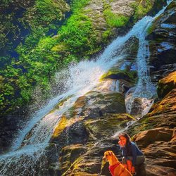
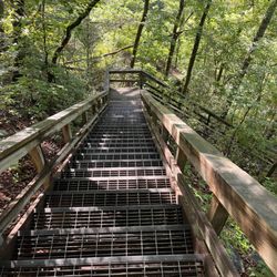
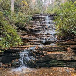
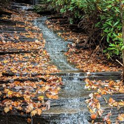
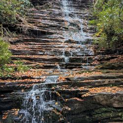
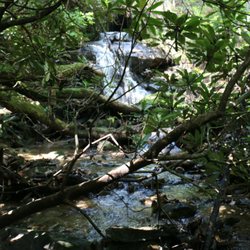
Stonewall Creek Falls is located on the trail known as Stonewall Falls & White Twister Mountain Bike Trail. It's an 11.5 mile trail used most often by mountain bikes (as the name would imply) and has multiple wet creek crossings. The parking area & trailhead are off Stonewall Creek Road, also known as Crooked Oak Road on one end and Carleton English Road on the other. Three names in less than 3 miles of road, but you would only know this if you are looking at Google Maps. [ DIRECTIONS ] The trailhead is approx. 1.3 miles from paved South Main Street in Tiger, GA. The road is gravel with no signage, but a small utility building with two power boxes surrounded by a chain link fence sits right on the corner. The road is a touch bumpy and is best for trucks, Jeeps, SUV's and vehicles with more clearance, but a car COULD make it through. [ THE TRAIL ] You'll know you've arrived when you reach a small forest service gate with a niche large enough for about 3 cars. There is also sufficient room for several more cars to park roadside. The Mountain Bike Trail has a 1492 foot elevation change and encompasses some of the roadway past the parking area. However, to get to the waterfall, go through the gate, cross the small creek and continue left downhill for about 1/2 mile. The waterfall will come into view near a large open camping area. [ THE FALLS ] The easiest waterfall to reach is the one at the camping area. It's approximately 20 feet tall. HOWEVER, there is another waterfalls upstream of the main falls, but it is difficult to reach. Scouting reports I have read say to use a steep side trail 100 yards or so further uptrail past the falls. You will see two faint trails and I've been told the first of the two is the better option, but be careful, BOTH are STEEP. I tried the second trail (didn't know the first trail was the better option at the time) and only made it halfway before turning back. It felt against my better judgement to try this alone with my tiny little dog. So I plan to come back on another day when I have another crazy adventurer with me for support (and possibly a 911 call). Just slightly upstream from the main falls is an easier path to Stonewall Creek. My thought is to try to wade through the river to the upper falls, which are far prettier according to some of the pics I've witnesses on hiking trail galleries: https://mtnimages.smugmug.com/Hiking-With-Mtnimages/Hike-to-Stonewall-Creek/i-bdsqddz/A TIP - If you hike upstream looking for the side trail to the upper falls and make it to a creek crossing, you've gone too far! There is also another waterfall downstream of the main falls, but requires some mountain goat skills and bushwacking, which I'm hoping to get into this summer as I want to trailblaze to more remote waterfalls. [ THINGS TO KNOW ] Hiking Distance: 1 miles (round trip to main falls) Difficulty: Easy & family friendly (main waterfall) Difficulty: Strenuous & dangerous (upper and lower falls) Creek Crossings: YES (1) small stream at the beginning Elevation Gain: n/a Waterfall Height: Approx 18-20 feet (main) Access to top of falls: NO Access to base of falls: YES Pool of water @ base of Falls: YES Sitting areas @ base: YES + camping area RESTROOMS: NO PARKING: YES (3+ cars) [ FINAL THOUGHTS ] I enjoy hiking very much! The beauty, serenity and adventure calls to me and the peace that comes from such adventures is simply unmatched. The only thing that disturbs my hiking serenity is when I can't reach my destination. I'm stubborn and bullheaded like that! The first waterfall was nice, but my mission was to see all three, or at the very least the main falls AND the upper falls.... so I left disappointed. Still, it was one of several waterfalls I toured today as I scouted new trails for my hiking groups 2020 expeditions. This is a great short hike to add to other longer hikes when looking to fill up a day. NOTE TO SELF: Be better prepared next time with trail map downloads and GPS trackers that work even offline to better navigate to falls that are off-trail. Also, bring a machete just in case some light bushwacking is required. 2020 / 9 read more


3 years ago
I love this places, beautiful, relaxing. I love to end here after mountain biking trails. Is not crowded place read more
More info about Stonewall Creek Falls


Why does Yelp recommend reviews?
1 review that is not currently recommended
The reviews below are not factored into the business's overall star rating.
3 years ago
Stonewall Creek Falls - landmarks - Updated July 2026
Best of Tiger
People found Stonewall Creek Falls by searching for…
Trending Searches in Tiger, GA
Cliff Jumping near Stonewall Creek Falls
Day Trips near Stonewall Creek Falls
Hiking near Stonewall Creek Falls
Kayak Rental near Stonewall Creek Falls
Landmarks & Historical Buildings near Stonewall Creek Falls
Off Road Trails near Stonewall Creek Falls
Peach Picking near Stonewall Creek Falls
Places To Swim near Stonewall Creek Falls
Public Shower near Stonewall Creek Falls
River Swimming near Stonewall Creek Falls
Rock Quarry near Stonewall Creek Falls
Scenic Drive near Stonewall Creek Falls
Scenic Overlook near Stonewall Creek Falls
Swimming Holes near Stonewall Creek Falls
Swimming Lakes near Stonewall Creek Falls
Watch Sunset near Stonewall Creek Falls
Waterfalls near Stonewall Creek Falls
Browse Articles
Browse Nearby
BEST of Tiger, Georgia Restaurants near Stonewall Creek Falls
BEST of Tiger, Georgia Things to Do near Stonewall Creek Falls
BEST of Tiger, Georgia Coffee near Stonewall Creek Falls
BEST of Tiger, Georgia Photo Spots near Stonewall Creek Falls
BEST of Tiger, Georgia Museums near Stonewall Creek Falls
BEST of Tiger, Georgia Breakfast near Stonewall Creek Falls
BEST of Tiger, Georgia Hotels near Stonewall Creek Falls
BEST of Tiger, Georgia Campgrounds near Stonewall Creek Falls
Browse Brands
Related Searches in Tiger, GA
Affordable Kayak Rental Services in Tiger, Georgia
Best Dog Hiking Trails Around Tiger, Georgia
Best Fishing Locations and Guides in Tiger, Georgia
Best Fun Things to Do in Tiger, Georgia
Best Lookout Points to Visit in Tiger, Georgia
Best Places for Horseback Riding in Tiger, Georgia
Best Sledding Spots and Fun in Tiger, Georgia
Best Spots for Star Gazing in Tiger, Georgia
Best Things to Do on a Rainy Day in Tiger, Georgia
Best Waterfalls and Swimming Holes in Tiger, Georgia
Book Engaging Historical Tours in Tiger, Georgia
Check Out Off Road Trails in Tiger, Georgia
Discover Charming Historic Homes in Tiger, Georgia
Discover Dog Friendly Trails to Explore in Tiger, Georgia
Discover Famous Monuments in Tiger, Georgia
Discover Historic Sites and Places in Tiger, Georgia
Discover Popular Landmarks in Tiger, Georgia
Discover Popular Photo Spots in Tiger, Georgia
Discover a Hiking Trail in Tiger, Georgia
Discover the Best Beaches in Tiger, Georgia
Discover the Best Night Hike Trails in Tiger, Georgia
Dog-Friendly Hikes With Dogs in Tiger, Georgia
Enjoy Exciting Mountain Biking Adventures in Tiger, Georgia
Enjoy Hiking Adventures in Tiger, Georgia
Enjoy Kayaking Adventures in Tiger, Georgia
Enjoy Off Leash Dog Hikes in Tiger, Georgia
Enjoy Tent Camping Spots Around Tiger, Georgia
Enjoy the Best Tubing Experiences in Tiger, Georgia
Enjoy the Best Walking Trails in Tiger, Georgia
Experience Stunning Sunset Views in Tiger, Georgia
Experience Thrilling White Water Rafting in Tiger, Georgia
Explore Beautiful Botanical Gardens in Tiger, Georgia
Explore Beautiful Castles and Landmarks in Tiger, Georgia
Explore Beautiful Parks and Green Spaces in Tiger, Georgia
Explore Easy Hikes Perfect for All in Tiger, Georgia
Explore Family-Friendly Zoos and Wildlife in Tiger, Georgia
Explore Free Things to Do Around Tiger, Georgia
Explore Fun Activities to Do in Tiger, Georgia
Explore Fun Field Trips in Tiger, Georgia
Explore Popular Campgrounds Near Tiger, Georgia
Explore Popular Day Trips From Tiger, Georgia
Explore Popular Scenic Overlook Points in Tiger, Georgia
Explore Popular Scenic Views Near Tiger, Georgia
Explore Secret Spots Worth Visiting in Tiger, Georgia
Explore Top Art Galleries Located in Tiger, Georgia
Explore Venues & Event Spaces in Tiger, Georgia