
Morse's Gulch Falls Photos


You might also consider
More like Morse's Gulch Falls
Recommended Reviews - Morse's Gulch Falls
Start your review...

2 years ago
Easy in and out, old fire road .Dense and secluded. Easier to approach from behind the school. read more
2 years ago
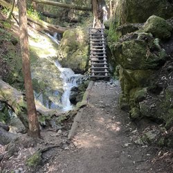
I was pleasantly surprised by this hike today. All the hikes I've done so far have been found in the book: Hiking Marin: 141 Great Hikes in Marin County http://www.amazon.com/Hiking-Marin-Great-Hikes-County/dp/0961704497 This hike was not on here. The actual trail was pretty easy to find despite not being marked (I took a photo from the entrance to make it easier to find). The start of the trail is on the Hwy 1 about 2.5/2.6 miles North of the Panoramic Hwy on the right hand side. There is a turnout that has enough parking for 2 cars. The waterfall itself was one giant drop about 50 feet. The length was about a little over a mile round trip. There were only 2 others on this trail since few know about it. Once you start the trail, you'll be on the left hand side of the creek. Then about 2/3 of the way through, you'll have to cross the creek. I recommend wearing long sleeves and pants as there is tons of poison oak. There are also tons of stinging nettles (not sure what they are, but I sure did feel them). It was a little muddy at the beginning and end of the trail, but not too much. You'll have to climb underneath, over, and through trees along the trail, but nothing too strenuous (A man and his 3 year old daughter were able to get to the falls easily). Even with all the photos I took, we were back to our car in about an hour, if that. =============== For more hiking recommendations: http://www.yelp.com/list_details?list_id=kc_cpimm3r3OA07lrBGKBA read more
 | www.eddie-hernandez.com - Parks Near Me - Stinson Beach, California")
12 years ago
Spacious adventure filled trails with a plethora of steps and a stunning view of Stinson Beach. I highly recommend coming on a weekday so parking is more feasible. Also bring water as there are plenty of hilly areas to keep you craving for more natural beauty. read more


More info about Morse's Gulch Falls
You might also consider


Morse's Gulch Falls - parks - Updated July 2026
Best of Stinson Beach
People found Morse's Gulch Falls by searching for…
Hiking Trails With Waterfalls in Stinson Beach, CA
Cliff Diving in Stinson Beach, CA
Things to Do in Stinson Beach, CA
Waterfalls in Stinson Beach, CA
River Swimming in Stinson Beach, CA
Natural Hot Springs in Stinson Beach, CA
Easy Hikes in Stinson Beach, CA
Secret Spots in Stinson Beach, CA
National Parks in Stinson Beach, CA
Waterfalls and Swimming Holes in Stinson Beach, CA
Lookout Points in Stinson Beach, CA
Scenic Drive in Stinson Beach, CA
Walking Trails in Stinson Beach, CA
Picnic Spots in Stinson Beach, CA
Redwood Forest in Stinson Beach, CA
Running Stairs in Stinson Beach, CA
Beautiful Views in Stinson Beach, CA
Picnic Areas in Stinson Beach, CA
Swimming Lakes in Stinson Beach, CA
Trending Searches in Stinson Beach, CA
Blueberry Picking near Morse's Gulch Falls
Boardwalk near Morse's Gulch Falls
Boat Tours near Morse's Gulch Falls
Cliff Jumping near Morse's Gulch Falls
Day Trips near Morse's Gulch Falls
Dog Friendly Beaches near Morse's Gulch Falls
Flower Fields near Morse's Gulch Falls
Indoor Dog Park near Morse's Gulch Falls
Jet Ski Rental near Morse's Gulch Falls
Kayak Rental near Morse's Gulch Falls
Kids Activities Indoor near Morse's Gulch Falls
Lakes near Morse's Gulch Falls
Peach Picking near Morse's Gulch Falls
Picnic Spots near Morse's Gulch Falls
Playgrounds near Morse's Gulch Falls
Public Beaches near Morse's Gulch Falls
River Swimming near Morse's Gulch Falls
Rock Quarry near Morse's Gulch Falls
Scenic Overlook near Morse's Gulch Falls
Splash Pad near Morse's Gulch Falls
Surf Shop near Morse's Gulch Falls
Swimming Holes near Morse's Gulch Falls
Swimming Lakes near Morse's Gulch Falls
Things To Do On A Rainy Day near Morse's Gulch Falls
Things To Do With Kids near Morse's Gulch Falls
Tubing near Morse's Gulch Falls
Browse Articles
Browse Nearby
BEST of Stinson Beach, California Coffee near Morse's Gulch Falls
BEST of Stinson Beach, California Restaurants near Morse's Gulch Falls
BEST of Stinson Beach, California Things to Do near Morse's Gulch Falls
BEST of Stinson Beach, California Playgrounds near Morse's Gulch Falls
BEST of Stinson Beach, California Breakfast near Morse's Gulch Falls
BEST of Stinson Beach, California Picnic Areas near Morse's Gulch Falls
BEST of Stinson Beach, California Natural Hot Springs near Morse's Gulch Falls
BEST of Stinson Beach, California Campgrounds near Morse's Gulch Falls
BEST of Stinson Beach, California Restroom near Morse's Gulch Falls
Browse Brands
Related Searches in Stinson Beach, CA
Best Off Leash Dog Parks in Stinson Beach, California
Best Parks for Parties and Events in Stinson Beach, California
Best Water Parks for Kids in Stinson Beach, California
Check Out Great Playgrounds in Stinson Beach, California
Discover Baseball Fields Around Stinson Beach, California
Discover Fun Toddler Parks in Stinson Beach, California for Your Little One
Discover Lakes & Ponds to Explore in Stinson Beach, California
Discover Popular Photo Spots in Stinson Beach, California
Discover Soccer Fields in Stinson Beach, California Near You
Discover Top Nature Parks to Visit in Stinson Beach, California
Discover Top State Parks to Visit in Stinson Beach, California
Discover Walking Parks in Stinson Beach, California Near You
Discover the Best Beaches in Stinson Beach, California
Discover the Best Kids Park Spots in Stinson Beach, California
Enjoy Scenic Places to Walk in Stinson Beach, California
Enjoy the Best Picnic Spots and Ideas in Stinson Beach, California
Enjoy the Best Walking Trails in Stinson Beach, California
Explore Easy Hikes Perfect for All in Stinson Beach, California
Explore Free Picnic Areas Around Stinson Beach, California
Explore Fun Activities to Do in Stinson Beach, California
Explore Parks With Pull Up Bars in Stinson Beach, California
Explore Picnic Parks Near Stinson Beach, California
Explore Popular Campgrounds Near Stinson Beach, California
Explore Popular Kids Parks Throughout Stinson Beach, California
Explore Popular Picnic Areas Around Stinson Beach, California
Explore Popular RV Parks Around Stinson Beach, California
Explore Scenic Lakes to Visit in Stinson Beach, California
Explore Top Dog Parks in Stinson Beach, California Near You
Explore Top Water Parks in Stinson Beach, California Today
Find Great Places to Feed Ducks in Stinson Beach, California
Find Parks and Recreation Activities in Stinson Beach, California
Find Top Dog Friendly Parks to Visit in Stinson Beach, California
Find Top Skate Parks in Stinson Beach, California for All Skill Levels
Find a Kids Birthday Party Park in Stinson Beach, California
Find a Park With BBQ Pits in Stinson Beach, California
Find the Best Parks BBQ Grills in Stinson Beach, California
Find the Best Parks for Picnics in Stinson Beach, California
Find the Best Playgrounds to Visit in Stinson Beach, California
Have Fun at a Splash Pad in Stinson Beach, California
Locate Tennis Courts Around Stinson Beach, California
Picnic Areas With BBQ Pits Available in Stinson Beach, California
Play at a Splash Pad Park in Stinson Beach, California
Popular Picnic Spots to Visit in Stinson Beach, California
Relax in Parks With Shade Areas in Stinson Beach, California
Safe and Fun Parks for Kids in Stinson Beach, California
Top Hiking Trails to Explore in Stinson Beach, California
Top Playgrounds for Kids to Enjoy in Stinson Beach, California
Top Swimming Lakes to Enjoy in Stinson Beach, California
People who viewed Morse's Gulch Falls also viewed
Morning Sun Trail
5 reviews
Rodeo Valley Trail
6 reviews
Loma Alta Open Space Preserve
4 reviews
Tiburon Uplands Natural Preserve
5 reviews
Gerbode Valley Loop Hike
3 reviews
Matt Davis-Steep Ravine Loop
91 reviews
Bald Hill Preserve
2 reviews
Eldridge Fire Road
1 review
Chimney Rock - Point Reyes National Seashore
30 reviews
Cascade Park
4 reviews