Mount Blue Sky Scenic Byway Photos


You might also consider
More like Mount Blue Sky Scenic Byway
Recommended Reviews - Mount Blue Sky Scenic Byway
Start your review...

Reviews With Photos

If you're in or around the Denver area and looking for a short trip just to see the mountains, this is an incredible place to go and do just that. It's roughly an hour from the city, and the road to the top takes you to over 14k feet in elevation, and I believe that it's the highest paved road in America. The area is managed by the US Forest Service, and so you can either pay $15 at the gate to get in, or they accept the America The Beautiful Pass. Once you're inside the gate, it's about a 30-40 min drive up to the top. Along the way, you'll pass Mt Goliath Nature Center and Summit Lake. You'll probably see a lot of goats, marmot, and potentially some other wildlife along the way. There are a variety of trails and several places to stop and take in some incredible views. During peak times, you'll want to make a reservation to enter, which can be done through the national park service website. Restrooms are available in several places along the way to the top. Long story short, I've done this drive probably a dozen or more times, and it's well worth making the time to check it out. If you've only got 1 day and you want to get high up in the mountains this is your best bet hands down. DO IT!

One of the most memorable places I've been to!!! Make sure you make your reservation ahead of time & leave ample time to drive up and down. You don't want to rush or miss anything! So many wow spots all along the route! The views were insane, and we saw lots of wildlife too! Big horned sheep, mountain goats, and marmots to name a few. Whenever we were sick of driving we would just pull over the enjoy the crisp air and take small hikes.

If you want to experience a 14-er from the comfort of your car, this is an amazing option. Keep in mind that the road is closed after Labor Day and there's timed entry when it's open. You can book a ticket online or try your luck at the gate (hint: 99% you won't get in). You can also come at 6:30pm and travel the road for free. Personally, I liked being here in the evening. You get amazing pictures during golden hour and you can see a lot of wildlife. The views are absolutely incredible and photos don't do the judgement. There's a chance of bad weather as conditions change quickly at this altitude, so be ready for strong winds, rain, lightning, and fog. It's hard to beat this experience unless you go climb mountains yourself. Highly recommend if you're in Colorado.

We had a wonderful day enjoying the magnificent sights along the scenic byway at a leisurely pace. My wife was a little nervous beforehand given what she had read about the road condition, lack of guardrails, etc., but she was glad I convinced her to do it as the sights were great. And, while we were planning on hiking in RMNP, this was a good way to adjust to the altitude. Load up the car with a picnic lunch and snacks, bring layers of clothing, and enjoy! It can be very cold and windy at the summit, even on the warmest of summer days. Plan appropriately as you'll want to get out and explore a bit. We were lucky to see goats, sheep, marmots, and miles of scenery on a beautiful day.

Since no one is talking about how scary the drive is: I will. This was both me and my mom's scariest experience of our life. The roads do NOT HAVE RAILS and there are narrow turns. We had to drive in the middle of the road most of the time bc of how scary it is. No rails and a 10,000 feet drop is a little wonky. We made it about half way up the mountain (14,000 feet) before we decided to drop out. But 5 stars for the beauty! We have never had an experience like this before. The views and everything was calming. It ended up snowing because of how tall we were! It was freezing but the pics/scenery were 100% worth the scary drive! We even saw a bald eagle! Worth the drive and hoping we can go again and go further!

Amazing mountain to go for a day hike. There are a lot of different places you can start your hike. I was visiting a friend and Denver and we took a trip up for the day. They have a few small lakes that you pass on the way that you can stop at and take a break (or jump in if your ready for the cold water!) Nice part about the mountain is that you can drive your car to the top so if you are a beginner hiker this can be an easy hike. However, it is very likely there may not be any parking at the top so you'll most likely have to hike a little bit. It does get cold up at the top! I'm from Florida and when I checked the weather in Denver it was almost 100 degrees but luckily my friend highly suggested bringing a jacket because the temp dropped to 55 degrees when we made it to the top. I wore a regular pair of Nike sneakers and it was easy making to the top. If you want to get to the peak you'll climb a small trail that isn't paved but it's not too bad. Once you make it to the top the view is worth it all. Just make sure you bring some water as you may get tired if you're not used to mountain elevation. Very scenic location and you'll even see a few goats at the top


Mount Evans Scenic Byway is North America's Highest Auto Road being 14 miles long and reaching an altitude of 14,260 feet in elevation. Because of its popularity, you now have to make reservations for gaining access to the drive. I booked my reservation almost 1 week in advance back over the summertime. Simply go to rec.gov and choose Mount Evans Scenic Byway. It was $17 for the reservation. Also, you must choose a time slot for when to enter the road. I'm a morning person so I was looking for the 8am - 10am slot but that was sold out. My next best option was 10am - 12pm, which still offered me more than enough time to do the 14 miles to the summit of Mount Evans and drive back down. The start of Mount Evans Scenic Byway begins just outside the town of Idaho Springs. And btw...you can only access the road during warm months when snow isn't on the ground. Basically, its closed in winter times. Now before going through the entrance station and beginning the drive, I did take a moment to stop in at the Echo Lake Lodge to buy a couple of souvenirs. Although Echo Lake Lodge didn't offer much, at least I found a couple of Mount Evans keepsakes. For Mount Evans Byway being only 14 miles to the top, I didn't find many worthwhile stops along the way that I was anticipating. So overall, maybe it took me 2 tours to drive to the summit. Along the way...let me mention a few areas I pulled over at... - Mount Goliath Natural Area - a quick stop here to use the restroom and read up a little about what to expect going up to Mount Evans. There really weren't any scenic spots for pictures unfortunately. Mount Goliath Area looked promising but wasn't anything meaningful. - Summit Lake Park - this was actually my first real stop and worthwhile area along the drive. And this was already at Mile 9 of the 14-mile road. So...the first 2/3's of the way to the peak, you're not afforded much. This Summit Lake Park was pleasant. There were some alpine mountains set all around with a giant lake situated in the middle. I suggest walking down to the lake for a few pictures with the mountains in the backdrop. One note...there was barely any snow covering on the mountains which left the surroundings kind of bare bones looking. Still, at least this Summit Lake Park offered some walking around. Don't forget to hike the Chicago Lakes Overlook Trail here - a hiking trail I recommend that'll lead you to an overlook vista point. At this observation point you can view out onto one grand scenic background. You'll see a couple of lakes down below splitting the center of the mountainsides for a postcard looking appearance! Btw...the trail is less than 1 mile long, basically a walking path to the viewpoint. Over the next 5 miles to the pinnacle, you'll drive along the edge of the cliff faced walls. Just be careful and go slow as you'll be making plenty of turns at all the switchbacks. It's nothing to be nervous about, but the elevation definitely kicks in for the last 5 miles and you may feel altitude sickness. Along the last section to the apex, you'll confront a bunch of mountain goats casually walking the sides of the road. They were all over the place and they're calm around humans. Don't worry about being that car taking pictures of the mountain goats or trying to say hello to them. Everyone was doing it so there may be a few traffic slowdowns over the last stretch. Finally making it to the summit of Mount Evans, get out of your car and venture around. First thing, there's a terrific sign I'd recommend taking a picture with. It states - "Summit of Mount Evans, Elevation 14,130 feet" - this a perfect opportunity to officially commemorate that you've arrived at the top! There's also The Castle in the Sky - a home someone once built to live up here. Now, this house is a good opportunity to view out onto the everlasting landscape including an observation section for nice family photo moments. Don't be surprised if you run into more mountain goats here. They've taken residence right beside the castle. It's funny. And btw, the mountain goats even hang out in the parking lot as well. Lastly up here, I definitely recommend hiking The Trail. It's located off to the left-hand side of the parking lot. It's not a real long or difficult trail (maybe 1 mile) but it will lead you up to the very tippy top of Mount Evans and from high high above you can pier out onto a whole new rugged and majestic looking mountain range in the distance. This trail was very popular. Outside of wandering around The Castle, most tourists were hanging out here at the "top of the world". The Trail is the main event activity at the peak of Mount Evans Scenic Byway. I departed back down Mount Evans in early afternoon. I used about 2/3's of the day completing the 14 miles each way. I liked my experience here for the most part before driving towards another scenic highway nearby called Independence Pass heading to Aspen, Colorado.

This drive is so beautiful in the Fall when the Aspens are showing off their beautiful colors! Did you know that Mount Evans Scenic Byway is the Highest Paved Road In North America at 14,130 feet (4,310 m)?? Too bad we couldn't take it up to the very top. We hit the road before sunrise. My son drove us (his gf, dad, and me) up to as far as we were allowed to go on this byway. We heard it was, but we were taking our chances. When we got to Summit Lake, the road was blocked to go further upward. It was indeed closed for the winter. We stopped and walked around Summit Lake Park. People hike from here to the Summit of Mount Evans. We could see quite a few hikers up on the ridge. There are a few information boards for you to view while at the Park. It was a very chilly morning with the strong wind! The two who live in CO were all bundled up! My husband & I were wearing sweatshirts. On our way down the mountain, we stopped in at Dos Chappell Nature Center. It's where the Mount Goliath Natural Area sign is. It's definitely worth a visit! We were so thrilled to see Bighorn Sheep on our ascent and descent from the mountain! It was so cool! They didn't seem at all bothered by vehicles. We were able to stop, or drive super slow, and take a few pictures of them! I want to go again and hopefully we'll be able to get to the top by car!

A magnificent and spectacular drive! 14 miles of winding, narrow pavement to the summit; worth every second. Not for the faint of heart. This drive can be unnerving and disorienting to many. Stay calm. They call it OMG Highway for a good reason! If you are afraid of heights, let someone else drive or keep your eyes on the yellow line to minimize anxiety. I've been to the top at least a dozen times. I find the drive to be incredibly amazing. I have no fear of heights and not at all weary that there are no rails. Just be mindful and drive slowly. No place for road rage. Others WILL have fear on this climb. Be kind. There are very few places to pull off on this highway. One of North Americas top 5 most dangerous highways. No guard rails (no room for them actually), winding hairpin turns all the way up. OMG Highway is the highest paved highway in North America. The weather can change in an instant and snow can happen in any month of the year. It may be 80F at the base at Echo Lake and 32F at the top. Bring a jacket, it is windy up there. Highly recommended to bring oxygen and stay hydrated as well. You can purchase oxygen at the Echo Lake store at the base. Teaming with beautiful wildlife, sensational views, twisted tree's, colorful flowers, and interesting facts. Visit the Ranger Park to learn interesting facts about life on the mountain. There is a gallery and a pathway garden at this stop. Summit lake is your first major stop before driving or climbing to the actual peak summit. The overlook here you see the Chicago Lakes. You can hike down and fish or just enjoy the trails and wildlife. This point also gives way to views of the mountain ranges to the north and mileage to the distant peaks you can see from here. Moving on to the peak are more hairpin turns and breathtaking views many only see in an airplane! There is a structure at the peak that once was a coffee house/restaurant. There is also an Observatory! Highest operating observatory @14,168ft! Restrooms are available at this location. Very common to have mountain goats with spiked horns. Remember, they are wild and can hurt you. At this parking lot you are at 14,130 ft! To reach the peak (14,260K) you can take a trail (worth the climb, but again, have oxygen and water) just to say you made it! This is a drive you will talk about for the rest of your life. An experience well worth the trip. If you are a low-lander before you arrive, give yourself at least 3-days to acclimate to elevation before going up that high.

My husband decided that it was time I became a real Coloradan, so last weekend he drove us up Mount Evans to complete my very first 14er! (Fine, technically I ascended my first 14er in a car, so I'll still need to actually climb a 14er...someday.) For $15, we got a day pass to go all the way to the top. If I have one takeaway from the whole experience, it's that the drive up is bound to stir up some emotions. For me, it was the anxiety about the possibility of going over the edge of a sheer cliff since the road was super windy, narrow, and has no guard rails whatsoever. Fortunately, that anxiety was countered by the sleepiness from the thin air. What's even more fortunate was that I wasn't the one driving. Anxiety-ridden drive up aside, the view once we got to the top was majestic and really hits you with the natural beauty that Colorado has to offer. Even though it was kind of a cloudy day and I wasn't really able to see for miles, what I could see was breathtaking. On the drive down, we stopped by the trail head by Summit Lake to take in the snow-capped mountains (in June) and take notes for when we'll be ready to hike up to the top in the future. Definitely take warm clothes, since the temperature changes quickly with increasing altitude. I took my knee-length winter coat with a faux-fur trimmed hood, and it still felt chilly to me during our June visit. This is definitely a must-do experience for anyone living in or visiting Colorado.

Filler up and let's go, STAT! Don't get me wrong...I LOVE to hike, but if I can DRIVE to the summit of a 14er? BAM! I'm in! Mount Evans is absolutely gorgeous! The drive can get a little narrow and sketchy at times, but worth every turn, twist and an occasional Rocky Mountain bighorn sheep crossing. The weather can be unpredictable on any given day, so be sure to check the forecast. The day we headed up, it said it was mostly cloudy...gotta say, the sun was shining almost the entire way up until we reached the summit. :-( All in all, while we couldn't "see for miles" we were happy we made it...took some awesome photos on the way up, met some cool people, wild bighorn sheep running around, Yellow Bellied Marmots making noise on a refreshing 41 degree day! We'll be back for sure! For more info, check out this website: https://www.codot.gov/travel/scenic-byways/north-central/mount-evans

5 days ago
I prefer Mt Blue Sky over Pikes Peak (Pikes Peak and Mt Blue Sky are the only 14ers in Colorado that you can drive to the top of). I think the views at the top are better. You can see a lot of other mountains from Mount Blue Sky and feel more in the wilderness. Fun fact, It is also the highest paved road in America! On our visit we got to see mountain goats. This was my first time seeing mountain goats in the wild. We did the quick walk up to the top of the mountain which was really cool and stopped over at summit lake. Make sure to reserve your timed entry! I actually do not mind that they do this because I feel like it would be hazardous if too many people were on the road up to Mt Blue Sky. There are no guard rails, cliffs off the side of the road, potholes, and the roads can be narrow in areas so not the ideal road to be busy. Very much a bucket list activity, though I definitely want to come back again vs just checking it off my list. read more


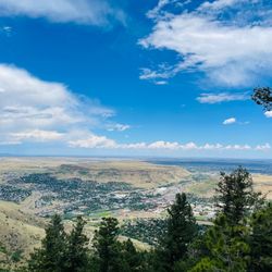
Although I've lived in Colorado for nearly 40 years, I'd never visited Mount Blue Sky Scenic Byway when it was still called Mount Evans because I'd heard the road was very steep. When I saw news reports about the name change, I realized the scenery was indeed stunning, and the road was entirely flat asphalt. Although most of the route runs along the edge of a cliff, if you drive slowly and pull over a bit when there's no oncoming traffic, it probably isn't as heart-stopping as the legends suggest. I was just planning to go when, unexpectedly, the scenic byway closed for two years. So as soon as it reopened--while there was still snow on the summit and road conditions were good--I hurried over. Driving from the city on I-25, then taking Highway 6 and connecting to I-70, it took about 40 minutes to reach the small town of Idaho Springs at the base of the mountain. On a Sunday afternoon, the town wasn't too crowded. While there are restrooms further up the mountain, they aren't as clean or convenient as the ones at the town's visitor center, so many tourists take care of business here before heading up. The visitor center also houses a paid museum where you can learn more about the history of this mining town. Across the street from the visitor center stands a statue honoring American pilots from World War II, modeled after the famous comic book hero Steve Canyon. This is also the last place before entering the mountains where you'll have a stable cell phone signal; once you're in the mountains, the signal disappears. The 14-mile drive from Idaho Springs to Echo Lake--located at an elevation of 10,600 feet just before the scenic byway entrance--follows a lush forest road that's a pleasure to drive. Since fishing is free in Colorado this weekend, there are quite a few anglers at Echo Lake. With its rippling turquoise waters and the lush, layered mountains in the background, the scenery is truly breathtaking and refreshing. There is an outdoor picnic area next to Echo Lake, and if you find the sun too strong or the weather unfavorable, you can take a break in the picnic area inside the stone building nearby. Less than a minute's drive from Echo Lake, a right turn leads to the Scenic Byway ticket booth. The attendant will tell you about the wildlife you might see on the mountain that day and remind everyone to just watch them--do not feed or touch them. The drive from the entrance to the Mount Goliath Natural Area at 11,540 feet is about 3 miles. Although the road follows the cliffside, towering pine and evergreen trees line both sides. Except for the final stretch, the valley is only faintly visible for most of the journey, making it a relatively easy drive. Looking out from the rest area, you'll see endless, layered mountain vistas. There's a trail through the tundra nearby that leads to the summit of Mount Goliath. After passing the Mount Goliath rest area, it's 6.2 miles to Summit Lake at an elevation of 12,830 feet. The entire route consists of tundra and mountain roads with no guardrails on one side--just a sheer cliff. Since the road winds around the mountain, the route runs half on the inner side and half on the outer side of the mountain, and it's very winding. It's fine when you're on the inner side, but when you're on the outer side, the cliff is right there. Fortunately, everyone drives slowly, but it's still quite nerve-wracking. Just before reaching Summit Lake, there's a patch of snow that hasn't melted yet by the roadside. Set against the western ridge of the summit, it looks as if you're on a glacier--it's a whole new world. Not far from there is Summit Lake, a high-altitude glacial lake. A short walk from the parking lot leads to the lakeshore. The surface of Summit Lake is as smooth as a mirror, reflecting the snow-capped ridges with such clarity that they appear to be exact replicas on the water--truly a scene of icy mountains mirrored in the water, ethereal and crystal-clear. The 5.3-mile stretch from Summit Lake to the summit at 14,264 feet is steeper and more rugged than the previous section. Many visitors turn back at Summit Lake, and I, too, didn't have the confidence or fortitude to drive another 10-plus miles of mountain road round-trip. So, after taking in the scenic beauty of Summit Lake, I headed back as well. Although it's only about 9 miles from the ticket booth to Summit Lake, the speed limit is no more than 20 miles per hour, so the round trip takes roughly an hour. Adding in the time spent at the scenic area, the total trip takes a little over two hours. read more


One of the 52 most peaks in CO that reaches 14K feet. Highest paved roadway in USA. This scenic way is a lifetime experience. A 30-40 minutes drive up to the peak along a very narrow road. Reservation needed to be made ahead to time to be able to get past the entry post. At the top of the peak, it's very windy and cold, about 20 degrees colder than ground level. The air is so thin, got dizzy walking around. There's parking lot and an old building. Also a trail available who want to hike to highest point. read more


If you're in or around the Denver area and looking for a short trip just to see the mountains, this is an incredible place to go and do just that. It's roughly an hour from the city, and the road to the top takes you to over 14k feet in elevation, and I believe that it's the highest paved road in America. The area is managed by the US Forest Service, and so you can either pay $15 at the gate to get in, or they accept the America The Beautiful Pass. Once you're inside the gate, it's about a 30-40 min drive up to the top. Along the way, you'll pass Mt Goliath Nature Center and Summit Lake. You'll probably see a lot of goats, marmot, and potentially some other wildlife along the way. There are a variety of trails and several places to stop and take in some incredible views. During peak times, you'll want to make a reservation to enter, which can be done through the national park service website. Restrooms are available in several places along the way to the top. Long story short, I've done this drive probably a dozen or more times, and it's well worth making the time to check it out. If you've only got 1 day and you want to get high up in the mountains this is your best bet hands down. DO IT! read more


One of the most memorable places I've been to!!! Make sure you make your reservation ahead of time & leave ample time to drive up and down. You don't want to rush or miss anything! So many wow spots all along the route! The views were insane, and we saw lots of wildlife too! Big horned sheep, mountain goats, and marmots to name a few. Whenever we were sick of driving we would just pull over the enjoy the crisp air and take small hikes. read more


3 years ago
If you want to experience a 14-er from the comfort of your car, this is an amazing option. Keep in mind that the road is closed after Labor Day and there's timed entry when it's open. You can book a ticket online or try your luck at the gate (hint: 99% you won't get in). You can also come at 6:30pm and travel the road for free. Personally, I liked being here in the evening. You get amazing pictures during golden hour and you can see a lot of wildlife. The views are absolutely incredible and photos don't do the judgement. There's a chance of bad weather as conditions change quickly at this altitude, so be ready for strong winds, rain, lightning, and fog. It's hard to beat this experience unless you go climb mountains yourself. Highly recommend if you're in Colorado. read more


We had a wonderful day enjoying the magnificent sights along the scenic byway at a leisurely pace. My wife was a little nervous beforehand given what she had read about the road condition, lack of guardrails, etc., but she was glad I convinced her to do it as the sights were great. And, while we were planning on hiking in RMNP, this was a good way to adjust to the altitude. Load up the car with a picnic lunch and snacks, bring layers of clothing, and enjoy! It can be very cold and windy at the summit, even on the warmest of summer days. Plan appropriately as you'll want to get out and explore a bit. We were lucky to see goats, sheep, marmots, and miles of scenery on a beautiful day. read more


2 years ago
Since no one is talking about how scary the drive is: I will. This was both me and my mom's scariest experience of our life. The roads do NOT HAVE RAILS and there are narrow turns. We had to drive in the middle of the road most of the time bc of how scary it is. No rails and a 10,000 feet drop is a little wonky. We made it about half way up the mountain (14,000 feet) before we decided to drop out. But 5 stars for the beauty! We have never had an experience like this before. The views and everything was calming. It ended up snowing because of how tall we were! It was freezing but the pics/scenery were 100% worth the scary drive! We even saw a bald eagle! Worth the drive and hoping we can go again and go further! read more


 - Hiking Near Me")
Amazing mountain to go for a day hike. There are a lot of different places you can start your hike. I was visiting a friend and Denver and we took a trip up for the day. They have a few small lakes that you pass on the way that you can stop at and take a break (or jump in if your ready for the cold water!) Nice part about the mountain is that you can drive your car to the top so if you are a beginner hiker this can be an easy hike. However, it is very likely there may not be any parking at the top so you'll most likely have to hike a little bit. It does get cold up at the top! I'm from Florida and when I checked the weather in Denver it was almost 100 degrees but luckily my friend highly suggested bringing a jacket because the temp dropped to 55 degrees when we made it to the top. I wore a regular pair of Nike sneakers and it was easy making to the top. If you want to get to the peak you'll climb a small trail that isn't paved but it's not too bad. Once you make it to the top the view is worth it all. Just make sure you bring some water as you may get tired if you're not used to mountain elevation. Very scenic location and you'll even see a few goats at the top read more


We walked down the road after hiking the ascent up. There were great views at the top and there's a cool castle, bathrooms, an observation deck and ample parking although you do have to make a reservation online ahead of time to go. The views from the road are incredible. read more


Mount Evans Scenic Byway is North America's Highest Auto Road being 14 miles long and reaching an altitude of 14,260 feet in elevation. Because of its popularity, you now have to make reservations for gaining access to the drive. I booked my reservation almost 1 week in advance back over the summertime. Simply go to rec.gov and choose Mount Evans Scenic Byway. It was $17 for the reservation. Also, you must choose a time slot for when to enter the road. I'm a morning person so I was looking for the 8am - 10am slot but that was sold out. My next best option was 10am - 12pm, which still offered me more than enough time to do the 14 miles to the summit of Mount Evans and drive back down. The start of Mount Evans Scenic Byway begins just outside the town of Idaho Springs. And btw...you can only access the road during warm months when snow isn't on the ground. Basically, its closed in winter times. Now before going through the entrance station and beginning the drive, I did take a moment to stop in at the Echo Lake Lodge to buy a couple of souvenirs. Although Echo Lake Lodge didn't offer much, at least I found a couple of Mount Evans keepsakes. For Mount Evans Byway being only 14 miles to the top, I didn't find many worthwhile stops along the way that I was anticipating. So overall, maybe it took me 2 tours to drive to the summit. Along the way...let me mention a few areas I pulled over at... - Mount Goliath Natural Area - a quick stop here to use the restroom and read up a little about what to expect going up to Mount Evans. There really weren't any scenic spots for pictures unfortunately. Mount Goliath Area looked promising but wasn't anything meaningful. - Summit Lake Park - this was actually my first real stop and worthwhile area along the drive. And this was already at Mile 9 of the 14-mile road. So...the first 2/3's of the way to the peak, you're not afforded much. This Summit Lake Park was pleasant. There were some alpine mountains set all around with a giant lake situated in the middle. I suggest walking down to the lake for a few pictures with the mountains in the backdrop. One note...there was barely any snow covering on the mountains which left the surroundings kind of bare bones looking. Still, at least this Summit Lake Park offered some walking around. Don't forget to hike the Chicago Lakes Overlook Trail here - a hiking trail I recommend that'll lead you to an overlook vista point. At this observation point you can view out onto one grand scenic background. You'll see a couple of lakes down below splitting the center of the mountainsides for a postcard looking appearance! Btw...the trail is less than 1 mile long, basically a walking path to the viewpoint. Over the next 5 miles to the pinnacle, you'll drive along the edge of the cliff faced walls. Just be careful and go slow as you'll be making plenty of turns at all the switchbacks. It's nothing to be nervous about, but the elevation definitely kicks in for the last 5 miles and you may feel altitude sickness. Along the last section to the apex, you'll confront a bunch of mountain goats casually walking the sides of the road. They were all over the place and they're calm around humans. Don't worry about being that car taking pictures of the mountain goats or trying to say hello to them. Everyone was doing it so there may be a few traffic slowdowns over the last stretch. Finally making it to the summit of Mount Evans, get out of your car and venture around. First thing, there's a terrific sign I'd recommend taking a picture with. It states - "Summit of Mount Evans, Elevation 14,130 feet" - this a perfect opportunity to officially commemorate that you've arrived at the top! There's also The Castle in the Sky - a home someone once built to live up here. Now, this house is a good opportunity to view out onto the everlasting landscape including an observation section for nice family photo moments. Don't be surprised if you run into more mountain goats here. They've taken residence right beside the castle. It's funny. And btw, the mountain goats even hang out in the parking lot as well. Lastly up here, I definitely recommend hiking The Trail. It's located off to the left-hand side of the parking lot. It's not a real long or difficult trail (maybe 1 mile) but it will lead you up to the very tippy top of Mount Evans and from high high above you can pier out onto a whole new rugged and majestic looking mountain range in the distance. This trail was very popular. Outside of wandering around The Castle, most tourists were hanging out here at the "top of the world". The Trail is the main event activity at the peak of Mount Evans Scenic Byway. I departed back down Mount Evans in early afternoon. I used about 2/3's of the day completing the 14 miles each way. I liked my experience here for the most part before driving towards another scenic highway nearby called Independence Pass heading to Aspen, Colorado. read more


3 years ago
This drive is so beautiful in the Fall when the Aspens are showing off their beautiful colors! Did you know that Mount Evans Scenic Byway is the Highest Paved Road In North America at 14,130 feet (4,310 m)?? Too bad we couldn't take it up to the very top. We hit the road before sunrise. My son drove us (his gf, dad, and me) up to as far as we were allowed to go on this byway. We heard it was, but we were taking our chances. When we got to Summit Lake, the road was blocked to go further upward. It was indeed closed for the winter. We stopped and walked around Summit Lake Park. People hike from here to the Summit of Mount Evans. We could see quite a few hikers up on the ridge. There are a few information boards for you to view while at the Park. It was a very chilly morning with the strong wind! The two who live in CO were all bundled up! My husband & I were wearing sweatshirts. On our way down the mountain, we stopped in at Dos Chappell Nature Center. It's where the Mount Goliath Natural Area sign is. It's definitely worth a visit! We were so thrilled to see Bighorn Sheep on our ascent and descent from the mountain! It was so cool! They didn't seem at all bothered by vehicles. We were able to stop, or drive super slow, and take a few pictures of them! I want to go again and hopefully we'll be able to get to the top by car! read more


A magnificent and spectacular drive! 14 miles of winding, narrow pavement to the summit; worth every second. Not for the faint of heart. This drive can be unnerving and disorienting to many. Stay calm. They call it OMG Highway for a good reason! If you are afraid of heights, let someone else drive or keep your eyes on the yellow line to minimize anxiety. I've been to the top at least a dozen times. I find the drive to be incredibly amazing. I have no fear of heights and not at all weary that there are no rails. Just be mindful and drive slowly. No place for road rage. Others WILL have fear on this climb. Be kind. There are very few places to pull off on this highway. One of North Americas top 5 most dangerous highways. No guard rails (no room for them actually), winding hairpin turns all the way up. OMG Highway is the highest paved highway in North America. The weather can change in an instant and snow can happen in any month of the year. It may be 80F at the base at Echo Lake and 32F at the top. Bring a jacket, it is windy up there. Highly recommended to bring oxygen and stay hydrated as well. You can purchase oxygen at the Echo Lake store at the base. Teaming with beautiful wildlife, sensational views, twisted tree's, colorful flowers, and interesting facts. Visit the Ranger Park to learn interesting facts about life on the mountain. There is a gallery and a pathway garden at this stop. Summit lake is your first major stop before driving or climbing to the actual peak summit. The overlook here you see the Chicago Lakes. You can hike down and fish or just enjoy the trails and wildlife. This point also gives way to views of the mountain ranges to the north and mileage to the distant peaks you can see from here. Moving on to the peak are more hairpin turns and breathtaking views many only see in an airplane! There is a structure at the peak that once was a coffee house/restaurant. There is also an Observatory! Highest operating observatory @14,168ft! Restrooms are available at this location. Very common to have mountain goats with spiked horns. Remember, they are wild and can hurt you. At this parking lot you are at 14,130 ft! To reach the peak (14,260K) you can take a trail (worth the climb, but again, have oxygen and water) just to say you made it! This is a drive you will talk about for the rest of your life. An experience well worth the trip. If you are a low-lander before you arrive, give yourself at least 3-days to acclimate to elevation before going up that high. read more


My husband decided that it was time I became a real Coloradan, so last weekend he drove us up Mount Evans to complete my very first 14er! (Fine, technically I ascended my first 14er in a car, so I'll still need to actually climb a 14er...someday.) For $15, we got a day pass to go all the way to the top. If I have one takeaway from the whole experience, it's that the drive up is bound to stir up some emotions. For me, it was the anxiety about the possibility of going over the edge of a sheer cliff since the road was super windy, narrow, and has no guard rails whatsoever. Fortunately, that anxiety was countered by the sleepiness from the thin air. What's even more fortunate was that I wasn't the one driving. Anxiety-ridden drive up aside, the view once we got to the top was majestic and really hits you with the natural beauty that Colorado has to offer. Even though it was kind of a cloudy day and I wasn't really able to see for miles, what I could see was breathtaking. On the drive down, we stopped by the trail head by Summit Lake to take in the snow-capped mountains (in June) and take notes for when we'll be ready to hike up to the top in the future. Definitely take warm clothes, since the temperature changes quickly with increasing altitude. I took my knee-length winter coat with a faux-fur trimmed hood, and it still felt chilly to me during our June visit. This is definitely a must-do experience for anyone living in or visiting Colorado. read more


Filler up and let's go, STAT! Don't get me wrong...I LOVE to hike, but if I can DRIVE to the summit of a 14er? BAM! I'm in! Mount Evans is absolutely gorgeous! The drive can get a little narrow and sketchy at times, but worth every turn, twist and an occasional Rocky Mountain bighorn sheep crossing. The weather can be unpredictable on any given day, so be sure to check the forecast. The day we headed up, it said it was mostly cloudy...gotta say, the sun was shining almost the entire way up until we reached the summit. :-( All in all, while we couldn't "see for miles" we were happy we made it...took some awesome photos on the way up, met some cool people, wild bighorn sheep running around, Yellow Bellied Marmots making noise on a refreshing 41 degree day! We'll be back for sure! For more info, check out this website: https://www.codot.gov/travel/scenic-byways/north-central/mount-evans read more


4 years ago
Very beautiful! The drive up was fairly easy... other than the sheep jam. We had some sheep blocking the road but that's okay! They are so cute and funny. They just stare at you. Kind of makes me laugh. We weren't able to go all the way to the summit which was a bummer. It was closed for the season. However, we were able to make it up to summit lake park. So many views! It was very very very beautiful up there. Definitely worth the drive and fee to get up there! read more


3 years ago
3 years ago
12 years ago
11 years ago
We took a drive out to Mt. Evans, hearing that it's the highest paved road in America with some amazing views. The drive took about an hour from Denver, and then about another 45 minutes to get up to the top. The road is very winding, and the views are indeed stunning. There are no guardrails and the roads can get icy, so I was driving at a more than safe-pace as to not plummet to a 4,000 ft drop. There are stops on the side of the road along the way so you may take photos, as well as rest stops for restrooms and gift shops. It cost $10 to enter the winding path, well worth it for a first timer in Denver - Best, Charlie read more


7 years ago
This is a must trip when in Denver and looking for a day trip to take I think!! The drive up is amazing!! Breathtaking views the whole way to Summit Lake. We couldn't go further though since the raid was closed at the lake. The drive was awesome but for the faint of heart or if you don't like heights. Wife said she had butterflies in her stomach the whole way up. It's a nice ride to take though. Just driving slow and taking in the views when you can or stopping at the pull offs for picture taking. We got to see some wildlife which was nice. A small group of Big Horn sheep, unfortunately there were no big Rams in the group we saw. Think we might have seen a Marmot running around at one spot we stopped at. We'll be going back soon to try some hiking around Summit Lake or further up the road maybe. read more


This is one of my favorite places to go in Colorado. When out of town guests visits (and the weather is right) I refer them or bring them on up this road in search of the great Mountain Goat (which are non native and were actually introduced by the state of Colorado's Division of Wildlife). My Mom has yet to recover from her trip up 2 summers back as she doesn't do so well with heights/narrow roads. You can purchase a day pass or a special parks pass which allows you access to other great parks such as Rocky Mountain National Park (this is the one I went for). You could also hike or bike up but I have yet to experience the urge. On the trip when I purchased the parks pass at the station/visitor center off of the highway the weather actually wasn't so great (viability was about 10-15 feet until you reached the summit) so the folks at the gate let us through without even seeing the pass (this made me a bit sad but I know the money goes to help the state parks and I'd be sure to get use out of it anyhow). Since moving here I don't tend to notice much with altitude changes but I can remember becoming a bit tired when I was a sea level liver. I did make sure my guest had been loading up on water since arriving to Colorado and I packed lots of tasty treats. I think the biggest notes here are to of course bring some warm clothes (just in case, mountain weather can change so fast), have a couple hours set aside (so you can take your time and not be in a rush, the traffic can be hectic), as well as some provisions. read more


A highlight of the week! Try to go on a sunny day for the best views. Cloudy days or reduced visibility greatly diminishes the experience. We brought sandwiches and ate lunch at the top. The views are outstanding and the mountain goats are amusing. There are multiple opportunities to stop and pull over to take a break from driving. read more


19 years ago
A friend of mine said this was a "must see" when visiting Denver. He said it was absolutely worth the drive and the time spent. After making the trip up I have to agree with him. Mt. Evans is the highest auto road in North America. You start in Idaho Springs and just keep going up for 28 miles. You feel like you are driving forever through the most beautiful scenery ever. Just when you think you saw the most awe-inspiring view, you make a tight hair-pin turn and are greeted with something even better. Even after the tree line ends and the air thins to 40% oxygen, the beauty does not end. Here you will see mountain goats and rams, I even saw a huge bird which I think must have been a hawk. The final few miles to the summit are scary. The road is very narrow and you must drive right at the edge (no guardrails) to let cars coming the other way pass and to get around the bicyclists. Yeah I said bicyclists. I couldnt believe how many of them there were and how they were zipping up this mountain like it was nothing. Boyfriend even shook one guys hand at the summit, telling him it was "dammed impressive". To me, cycling up to 14,269 feet is not only impressive, its stupifying. Be aware that due to this road and the altitude, they will close this road at a moments notice. As we were leaving a big storm cloud was coming close and we heard they were most likely going to shut it down because of that. I would imagine its closed for good from about November-April. I sure as heck wouldnt want to plow it! I didnt feel the effects of the lowered oxygen until after we got out of the car and started to walk down this dirt path to the observatory. After about 50 feet I had to stop I was wheezing like an old woman. But if you rest for a second you feel fine again and can continue on. I had heard it might be cold, but it felt fine to me. There was a stiff breeze, but I was able to just throw on a hoodie over a tank top. I would guess any other month than August and you might need a bit more. Sean J's review really says it all. Except I have to revise one part of it. He recommends biking to the summit and catching a ride down. Well, if you are anything like me you will want to catch that ride going UP and then biking DOWN. That is the better deal I think! read more


Well this did not disappoint. Now, luckily for me, I have no issue with altitude sickness, so I do think its worth being careful if you're not sure how you'll do this high up. We were lucky enough to come with friends who had been before, and they knew all the ins and outs. For example, they knew to pack lots of great snacks. Not because you work up such a hunger from all the hiking (which is only a quarter of a mile after the long drive to the top), but just because I really like snacks. We had popcorn, GORP, and some fruit. They also knew that we would need some warm clothes for the top. It was 90 degrees in Denver, but it was 50 at the top. I was very thankful for the thin down jacket even on such a sunny day. We took a ton of pictures, but the best part was the amazing views and the fresh air. On the drive home, we saw this amazing guy. It seriously looked like it was posing! read more

7 years ago
Beautiful view throughout drive. The roads are curvy and a little rough in places and very narrow but well worth the drive. Though the terrain is rough, the views are unforgettable and the wild life and wild flowers are beautiful. The landscape is rugged at times and very scenic at other times. Large vehicles may find it challenging. read more

7 years ago
This was worth the scary drive up. We were so excited that the mountain goats were out! The scenery was breathtaking even though the drive was nerve wracking. We were staying in Estes Park and this was so worth the drive. I'm happy that our family got to experience this. Make sure to leave early enough so you don't get stuck trying to leave the mountain in the dark. That would be terrifying and besides, you wouldn't even able to see the beautiful scenery on the way down. I did get a little altitude sickness once at the very top but it was worth it. read more


11 years ago
A wonderful place to spend a couple of hours out. First of all, I believe this is the highest paved area you could actually drive up to, a bit over 14,000 feet. Secondly, you are almost surely to see wildlife. We saw antelope, Mountain goats at very close range and marmots. When you get to the top, there is an additional area where you could actually climb to the technical peak, a strenuous 200 feet. Or, you could do it the lazy man's way and just stay in the parking lot and just enjoy the goats going by you. There are restrooms on top and plenty of park rangers to pick their brains over. It's really a lovely place to go to and dramatically scenic. read more
 - Hiking Near Me")


15 years ago
12 years ago
It was definitely a site you will never see in other places. You can drive to the peak and only have to walk about 200 yards from there to the top. Make sure to wear warm clothes because I went on September 1st and it was about 35 degrees at the top with at least 20 mph winds. It's also pet-friendly but a leash is "recommended". If they fall off the top of the mountain you will probably pass them on the way back down as you're driving but it won't be a great site to see. There is also bathrooms at the top and mountain goats at the top as well. If you want to spice up your trip get really close to them and they will charge at you and it will stress out the older people but it'll be something that everybody will remember. The drive to the top is quite a long one but if you're stuck behind someone, just start taking pictures instead of getting mad and wanting to pass them. We are all tourists here ;) read more


 - Hiking Near Me")

Whoa!!!! What a beautiful beautiful place!!!! Driving up and seeing all the wildlife... The water... The trees.... The mountain goats and rock formations! It's well worth the scenic drive! When you get to the summit, take your time... As some experience "altitude sickness"... lightheadedness... etc. My hubby and I experienced a little lightheadedness, while one of my little ones got sick. Easy breathing and some water helped. If we had a little more time and I didn't have a bun in the oven, then we would make the hike up the rest of the mountain. Otherwise... This was awesome!!!! This wasn't too long of a drive and there was plenty to see for young kids and adults!!! :) read more


8 years ago
Great place to drive up a mountain with plenty of stopping areas along the way. A small amount of hiking to get the right views and not get too winded. The wildlife was a joy to watch. read more


Page 1 of 2
More info about Mount Blue Sky Scenic Byway
Ask the Community - Mount Blue Sky Scenic Byway
During the thanksgiving week will I be able to drive to the top of Mt. Evans or will it be closed? Last time I visited Mt. Evans in early April, last 9 miles were blocked due to snow.
It will probably snow by that time again:( The best season would be June-August to get to the top.
Review Highlights - Mount Blue Sky Scenic Byway


Why does Yelp recommend reviews?
1 review that is not currently recommended
The reviews below are not factored into the business's overall star rating.
11 years ago
Mount Blue Sky Scenic Byway - hiking - Updated June 2026
Best of Evergreen
People found Mount Blue Sky Scenic Byway by searching for…
Hot Springs in Evergreen, Colorado
Things to Do in Evergreen, Colorado
Scenic Drive in Evergreen, Colorado
Watch Sunset in Evergreen, Colorado
Scenic Overlook in Evergreen, Colorado
Hiking Trails in Evergreen, Colorado
Sunrise View in Evergreen, Colorado
National Parks in Evergreen, Colorado
Playgrounds in Evergreen, Colorado
Fishing in Evergreen, Colorado
Photo Spots in Evergreen, Colorado
Campgrounds in Evergreen, Colorado
Beautiful Views in Evergreen, Colorado
Easy Hikes in Evergreen, Colorado
Picnic Areas in Evergreen, Colorado
River Swimming in Evergreen, Colorado
Off Leash Dog Hiking Trails in Evergreen, Colorado
Lookout Points in Evergreen, Colorado
Wildlife Park in Evergreen, Colorado
Sunrise Hike in Evergreen, Colorado
Trending Searches in Evergreen, CO
Black Owned Nail Salons near Mount Blue Sky Scenic Byway
Boardwalk near Mount Blue Sky Scenic Byway
Boat Rental near Mount Blue Sky Scenic Byway
Cliff Jumping near Mount Blue Sky Scenic Byway
Creeks near Mount Blue Sky Scenic Byway
Day Trips near Mount Blue Sky Scenic Byway
Dog Friendly Beaches near Mount Blue Sky Scenic Byway
Dog Friendly Things To Do near Mount Blue Sky Scenic Byway
Fishing Spots near Mount Blue Sky Scenic Byway
Free Picnic Areas near Mount Blue Sky Scenic Byway
Jet Ski Rental near Mount Blue Sky Scenic Byway
Kayak Rental near Mount Blue Sky Scenic Byway
Kids Activities Outdoor near Mount Blue Sky Scenic Byway
Lakes near Mount Blue Sky Scenic Byway
Lakes & Ponds near Mount Blue Sky Scenic Byway
Outdoor Activities near Mount Blue Sky Scenic Byway
Outdoor Basketball Courts near Mount Blue Sky Scenic Byway
Paddle Boat Rentals near Mount Blue Sky Scenic Byway
Parks For Picnics near Mount Blue Sky Scenic Byway
Pick Your Own Farms near Mount Blue Sky Scenic Byway
Places To Walk Around near Mount Blue Sky Scenic Byway
Public Shower near Mount Blue Sky Scenic Byway
River Swimming near Mount Blue Sky Scenic Byway
Rock Quarry near Mount Blue Sky Scenic Byway
Sand Volleyball Courts near Mount Blue Sky Scenic Byway
Scenic Night View near Mount Blue Sky Scenic Byway
Scenic Overlook near Mount Blue Sky Scenic Byway
Secluded Spots near Mount Blue Sky Scenic Byway
Soccer Store near Mount Blue Sky Scenic Byway
Splash Pad near Mount Blue Sky Scenic Byway
Strawberry Picking near Mount Blue Sky Scenic Byway
Sunbathing near Mount Blue Sky Scenic Byway
Sunrise View near Mount Blue Sky Scenic Byway
Swimming Holes near Mount Blue Sky Scenic Byway
Swimming Lakes near Mount Blue Sky Scenic Byway
View Fireworks near Mount Blue Sky Scenic Byway
Browse Nearby
Browse Brands
Related Searches in Evergreen, CO
Affordable Kayak Rental Services in Evergreen, Colorado
Best Fishing Locations and Guides in Evergreen, Colorado
Best Off Leash Dog Parks in Evergreen, Colorado
Best Parks for Parties and Events in Evergreen, Colorado
Best Places for Horseback Riding in Evergreen, Colorado
Best Water Parks for Kids in Evergreen, Colorado
Check Out Great Playgrounds in Evergreen, Colorado
Check Out Off Road Trails in Evergreen, Colorado
Discover Baseball Fields Around Evergreen, Colorado
Discover Beautiful Garden Spots in Evergreen, Colorado
Discover Dog Friendly Trails to Explore in Evergreen, Colorado
Discover Free Parking Options in Evergreen, Colorado
Discover Fun Toddler Parks in Evergreen, Colorado for Your Little One
Discover Lakes & Ponds to Explore in Evergreen, Colorado
Discover Popular Photo Spots in Evergreen, Colorado
Discover Scenic Mountain Bike Trails Near Evergreen, Colorado
Discover Scenic Waterfall Spots in Evergreen, Colorado
Discover Soccer Fields in Evergreen, Colorado Near You
Discover Top Nature Parks to Visit in Evergreen, Colorado
Discover Top Scenic Spots to Visit in Evergreen, Colorado
Discover Top State Parks to Visit in Evergreen, Colorado
Discover a Hiking Trail in Evergreen, Colorado
Discover the Best Beaches in Evergreen, Colorado
Discover the Best Kids Park Spots in Evergreen, Colorado
Discover the Best Night Hike Trails in Evergreen, Colorado
Dog-Friendly Hikes With Dogs in Evergreen, Colorado
Enjoy Camping Adventures Around Evergreen, Colorado
Enjoy Exciting Mountain Biking Adventures in Evergreen, Colorado
Enjoy Kayaking Adventures in Evergreen, Colorado
Enjoy River Tubing Adventures in Evergreen, Colorado
Enjoy Tent Camping Spots Around Evergreen, Colorado
Enjoy Water Activities and Fun in Evergreen, Colorado
Enjoy a Beautiful Waterfall Hike in Evergreen, Colorado
Enjoy the Best Picnic Spots and Ideas in Evergreen, Colorado
Enjoy the Best Tubing Experiences in Evergreen, Colorado
Enjoy the Best Walking Path in Evergreen, Colorado
Enjoy the Best Walking Trails in Evergreen, Colorado
Exciting Cliff Jumping Spots in Evergreen, Colorado
Experience Thrilling White Water Rafting in Evergreen, Colorado
Explore Beautiful Botanical Gardens in Evergreen, Colorado
Explore Beautiful Parks and Green Spaces in Evergreen, Colorado
Explore Easy Hikes Perfect for All in Evergreen, Colorado
Explore Family-Friendly Zoos and Wildlife in Evergreen, Colorado
Explore Free Picnic Areas Around Evergreen, Colorado
Explore Fun Activities to Do in Evergreen, Colorado
Explore Parks With Pull Up Bars in Evergreen, Colorado
Explore Popular Campgrounds Near Evergreen, Colorado
Explore Popular Picnic Areas Around Evergreen, Colorado
Explore Popular RV Parks Around Evergreen, Colorado
Explore Popular Recreation Centers Around Evergreen, Colorado
Browse Articles
People who viewed Mount Blue Sky Scenic Byway also viewed
St Mary's Glacier
129 reviews
Mt. Evans Wilderness
34 reviews
Golden Gate Canyon State Park
97 reviews
Genesee Park
19 reviews
Staunton State Park
61 reviews
Clear Creek Trail & Water Park
10 reviews
Mt. Galbraith Park
28 reviews
Elk Meadow Stagecoach Trailhead
77 reviews
Apex Trail
34 reviews
Charlie Tayler Water Wheel
6 reviews