Olomana Hike Photos


You might also consider
More like Olomana Hike
Recommended Reviews - Olomana Hike
Start your review...

Reviews With Photos

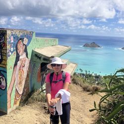
AKA 3 Peaks, Located near Royal Hawaiian Golf Course in Kailua. Also near Castle Hospital. When you come on Kalanianaole Hwy you get off on Auloa Rd. The parking is straight ahead across from the bus stop. There is a sign saying "do not park on concrete" so you need to park on dirt and grass. I saw someone with a ticket. To do all 3 Peaks and get back it takes about 6 hours. Then you have to walk about 0.8 miles to get to the start of the hike (see photo). You walk along the road that runs parallel to the Hwy in Waimanalo direction and then turn towards the mountain and go past the gate. There is a warning sign saying the number of people who died. But as long as you are careful and it is not pouring rain, it's not too different from other hikes and climbs. First peak takes about 1.5 hours. There are some ropes on the way up but they are not tough or always necessary. There is a rope near the top of first peak which might be difficult for kids under 12 (see photo) There are good views from all 3 peaks (see photos). PRO TIP: use roots and thick branches to help going up and down. Then it takes about 30 mins to get from First peak to Second peak. Then it takes about 45-60 mins to get from Second peak to Third peak. Some one has a box at the top of Third peak where you can leave a sticker or paper to say you made it (see photo). Definitely bring some water and plan your day based on how many peaks and how long you will be there.

We hiked the first peak with our kids (ages 9 and 8) who did not have proper shoes (no traction) and the hike was doable. No parking near the trail head. One has to park in the Maunawili neighborhood, outside of the golf course and then walk to the trail head, about half a mile. We hiked the trail two days after it rained so it was still little bit wet and slippery. One goes through various types of vegetations and we even saw wild boars. Several places toward the top have ropes which are helpful when climbing. It took us two hours to get to the top (took a lot of breaks and were slow) and one hour to get down. The last part of the hike is quite dangerous (vertical climb) and we didn't let our kids climb up. Overall, it was a very nice way to spend the day and push our kids' limits a bit. (We did this hike 12 years ago when we were living here and it was nice to come back with our children.)

I have so much to say about this hike! I loved it. It's now one of my all-time favorite hikes. It reminds me of my favorite hike in Oregon, Munra: https://www.yelp.com/biz/munra-point-trail-cascade-locks First of all, let's get a few disclaimers out of the way: Being in the mountains is inherently dangerous. Hiking is inherently dangerous. When tens of thousands of people do a hike, some will get injured, and some will die. The further you get from being on the couch watching Netflix, the more danger you add to your lifestyle. Some people are content to watch documentaries about nature, some people think getting up in nature's face is worth the risk. I was actively discouraged by locals from doing this hike after the rain. I was also actively discouraged from going to the third peak. I was also told it would take all day. I did this hike after 3 days of rain, all the way to the third peak and I found it pretty tame (I only had to grab a rope once on the way up, and once on the way down) and it ended up taking half a day. If you have experience with technical climbing on 5th class terrain and scrambling on 4th class terrain, you will likely think the same thing. If you don't know what either of those terms mean, you should probably heed the local advice and only go to the first peak and not do this hike after the rain. If you are an avid hiker, expect it to take you 3-5 hrs RT. I thought the hardest climbing was a 20ft section to get up to the first peak. I thought the hardest section of trail, BY FAR, was down-climbing from the 2nd peak to access the 3rd peak. Both sections are protected by ropes. If you can get to the first peak, you can easily get to the 2nd. The 3rd is significantly more difficult, but that's primarily because getting DOWN off the second peak is pretty steep. I inspected every rope anchor on the trail and...most of them were pretty good. Even the ones that looked crappy were backed up multiple times. Also, the ropes and anchors don't need to be all that great ("bomber" as we say in climbing) compared to climbing anchors, as they are only holding your body weight. The views up here are phenomenal. The best are from the 1st and 2nd peaks. The summit of the 3rd is pretty brushy and there aren't really 360 degree views like on the first two. What I will say is that the first half of this trail gets REALLY muddy after the rain. It's annoying. You'll probably fall, but you'll laugh about it. I went up before sunrise so I could have the peaks to myself, it was incredible. I may have sung a couple rounds of the Jurassic Park theme. Coming down, and seeing how woefully unprepared the people going up were (no water, crappy footwear, stumbling on easy terrain, out of shape)...I understand how people sometimes die up here. Protip: hit up Lanikai brewing on the way out, it's less than 2 miles from the trailhead! https://www.yelp.com/biz/lanikai-brewing-company-kailua-4

I hiked this & many other trails on 09/12 during my first visit to Hawai'i & posted a vlog! Search "Nikko Gandia Travels" on YT. Prepare for rock scrambles towards the latter half of the hike to the 1st peak. There are ropes, if needed, on certain sections. I'm not a mountain climber but did not need to use these ropes. If you need visuals for these climbing sections, they're in my vlog. ;) This trail is challenging in a fun way, I can't wait to go back and hike the other 2 peaks. Great views of east O'ahu and the Ko'olau ridge at the summit.

Great hike. Three peaks. For your convenience, they each increase in danger level, the third being a razorback trail with drops on both sides. Fortunately, the first peak is the highest so if you're in it for the view, you can satisfy yourself after only hiking the first peak. There is a bit of scrambling even on the first peak and more if you continue on to the second and third peaks, so be aware of that.

One of my favorite hikes of all time! It is quite challenging at certain and not for the lighthearted at the top. The parts that you have to climb, there are ropes but they're muddy and sometimes not useful. The top of the first peak is amazing with 360 views but for those afraid of heights, can be scary Bc you can be from ridge to ridge. The hike there was also interesting with differ plant species and such. It can get veryyyyy muddy as it did for us, it rained the day before. Hiking shoes highly recommend but we saw some earth people going barefoot. Park outside the golf course entrance and walk through. There will be a sigh for the start of the hike on the left side. Mud starts there... be prepared!

I'm not a regular hiker, so when my friends said let's hike Olomana I had no idea what I was in for. We went as a huge group of about 12. It was a nice day but we got started late, like almost noon. Because there was a lot of us, I would say I took us about 6 hours round trip. Quick pointers: 1. It's not your average hike. There are some narrow trail spots. Other parts where you need to climb ropes. Other spots might be windy. Come prepared. 2. If you're afraid of heights (like I am) you might want to really think twice about this. It requires a surety especially when you're climbing some of the ropes. You cannot be second guessing, it could be dangerous. I have a tendency for my legs to get shaky from certain heights and that's not something that would be ideal on this hike. I'll be honest, there was one point I could not go any further because of my fear of heights. I later found out from my friends I was only about 5 minutes from the top of the first peak. 3. Water and snacks are must. We only brought a small water bottle for each person (we were totally unprepared for this hike). Bring a couple water bottles and maybe some trail mix to keep your energy. 4. Don't do think hike if weather conditions are less than ideal. Like I mentioned certain spots ware windy. Certain parts of the trail are narrow. I would not recommend doing this hike even if it's been raining the day before, because of safety concerns.

An absolutely gorgeous hike with 360 degree views of the island. However, not for the faint of heart. If you have a fear of heights or are a poor rock climber or rope climber, you may want to reconsider this hike. You should be able to make it to the first peak no problem, but the other two peaks will be challenging. Olomana is highly weather dependent. I would not recommend this hike on a rainy or windy day. The path can get very muddy and a strong breeze can make certain parts of the trail sketchy. Not worth it. Wait for better weather conditions. If you are lucky enough to have good weather and have a decent level of athleticism, be sure to pack: Sunscreen - beyond the first peak there is virtually zero coverage from the sun Water - better to overpack this. My boyfriend and I shared about 56oz of water and I still managed to get a bad headache after the hike. Hat - sun protection Good shoes - when it's dry, the dirt is crumbly and it is hard to get a good grip. I went in trainers and slipped on a flat surface. Snacks - From start to finish, the hike took us 4 hours round trip. We kept a good pace and didn't take long breaks at each peak. If you're like me, you'll get hungry within 4 hours. Snacks are a must! Other things to note: Parking is a tough one. It's far from the entrance of the hike. The road that leads to the entrance belongs to the golf course and they have security that prevents you from parking there. If possible, it's best to have someone drop you off and pick you up. Overall, the hike was a great experience. I had always wanted to do Olomana and it was not as terrifying as I had thought it would be. I found Koko head crater to be more scary (though it was windy the day I went). Be careful when attempting this hike. If you play it safe and only do what you're able to, you'll be just fine. Happy Hiking!

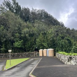
Had a great time on the hike with some friends. Car got towed though, unfortunately. BE SUPER CAREFUL WHERE YOU PARK, see the image I attached. You must park quite far from trailhead. Only did the first peak, was beautiful though. Would go back and do more some time, if I'm with a more adventurous group. TRY NOT TO GO WHEN IT RECENTLY RAINED AS WELL.


Arrived here at 5am to try and make it to the first peak for sunrise. If you plan on doing this be sure to bring headlamps as it gets dark under the trees on the trail (even with the moon out). *Do not park on the loop road leading up to the golf course you will get towed. You can park down the road right across or in front of the bus stop and walk in. This is my absolute favorite hike on Oahu as it involves some rock climbing and has the most spectacular view on the first peak. There are many areas where there are ropes, but we tried not to rely on them much as you do not know how stable they are or if they have been tampered with (could be someone's idea of a 'joke'). Always test them out and never put your full weight on them, just use as a support to be safe. Be sure to wear clothes you don't mind getting dirty as it can get muddy even if it rains a little. Some clouds were passing through and it started raining on our way down but it was still manageable, just very slippery. I did this hike about 2 years ago and I made it to the top in about 45-1hour. But his time around it took much longer because I am out of shape. The distance is short but keep in mind you are climbing almost straight up so you will feel it in your legs! Mine definitely felt like jello on the way down haha. We did not go to the second or third peak because the rain was coming in and it can be very dangerous. Some people have lost their lives there. All in all this is NOT a hike to miss! Just mind your safety, the weather, and your footing.

Parking: make sure to park your car BEFORE the bridge. If you park across the bridge (as tempting as it may be) you will get towed. To get to the trail, you need to cross the bridge and follow the road. You will pass the security guard on your left, don't worry its cool. Keep following the road until you see this sign: http://www.yelp.com/biz_photos/olomana-hike-kailua#DaSu8JdMCOp4Eb1vGN_SQQ When we started the hike it was pretty muddy, probably because we had a storm a couple days ago. But once we got higher in the trail it was all dry. Yay no more mud! You'll eventually reach an abandoned house, go left and follow the path till you get to the top where there is a fork and go right. After that the trail is pretty straight forward and takes you to the peaks. The part most of my friends and I had difficulty on was the 'rock climbing'. It sounds worse than it really is. The part that makes it so difficult is the fact that you're tired by the time you reach it. Another reason we found this part to be a little hard was because we are Asians; we are kind of vertically challenged... So trying to reach up high and finding placing for our footing is more difficult. We only made it to the first peak, but that was good enough for me! The view was amazing! To my right was the beautiful green mountain ridges and to my left was the beautiful beaches. I was amazed that I could see Chinaman's hat, Lani Kai and Makapuu all in one view! CRAZY. I definitely felt accomplished that I made it to the top! I won't lie though; it is a bit scary at the top. I mean I feel like if it was a windy day, I could have easily lost balance and fall off the cliff. It's all rocks at the top. No branches or trees to grab onto if you did end up falling. 0____0 so scary! Overall: This hike was worth it, but hard. I'm not a super experienced hiker, so for me I found this hike to be a little difficult. TIPS: + Bring water + Have Good Shoes + Hike with a friend, never alone. + Take breaks! + DO NOT do this hike if it's raining or rained the night before.

Note: I only hiked to the first peak. Quick Tips: Start at 8 or 8:30 at the latest on summer days. It gets hot quick around 10. Go with someone who has been there before or is good at impromptu rock climbing. Try to get rid of unnecessary weight (extra keys, DSLR cameras) Maybe bring glasses to help block the dirt from flying into your eyes. Don't wear long sleeves in the forest part. One 16.9 oz. bottle of water was enough for the most part assuming you head home right after. Not recommended for people with bad knees. Parking: As stated before, you can look up 770 Auloa Rd. (Street signs may say Auloa St.) From there you will follow Loop Rd. (as seen on google maps) Park next to the fences but not past the bridge as shown my pictures (police were monitoring parking today). Finding the Path: Walk up Loop Rd. to the guard shack for the Royal Hawaii Golf Club. The guard was really helpful today; letting us know that it may be muddy/slippery so you need to be careful especially at the top of the first peak where you need to climb. From the shack, you walk 1/3 miles up the road. You will see the Olomana Trail sign on your left. Trail to Peak 1: Most of the hike is actually dull until you get to the final 1/4 - 1/5. Follow the beaten path. Do not head down the loose red dirt trail when you get to the split. Take your time climbing up the rocks. Don't be afraid to use the rope. I was huge a punani heading back down. Caught the whole thing on my gopro. There is no kindergartner who can count up to the amount of times I said "F*CK" coming down that top boulder. No one's seeing that clip any time soon. O_O Luckily my friend went first so he could nav my feet for me. Hence, don't go alone. You'll need a second set of eyes to help you get down the parts with blind spots. Estimated time is about an hour going up unless you take big/quick steps. It takes longer to come down than to go up.

8 days ago
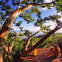
This is not for the faint of heart. First peak is an hour and a half of serious cardio. Rope sections and rapid, steep elevation. Pic is from second peak. Don't forget to bring enough water and snacks. read more


Tl:dr: the most technically challenging hike on the island, takes 5-6 hours round trip including stops on each of the 3 peaks to take pictures, rest etc. People talk about mortality on this trail, although I don't think it's as dangerous as people made it out to be if you exercise common sense. Who should do it: most people can make the 1st peak. Trail from 1st to 2nd becomes noticeably narrower but it's short and about the same level of difficulty as trail up the 1st peak. 2nd to 3rd peak was where the challenge is - lots of vertical rock climbing, path is narrow, and ropes aren't all in good conditions. If you don't have good upper body strength, have knee problems, or are afraid of heights, it's not a good idea to do the 3rd peak. If you don't have good endurance, it's just going to be a long day. Words of caution: try avoid going after a rainy day because the trail becomes very muddy. It started raining when I was coming down from the 3rd peak and the ground became slippery. Better to go with a friend if you can - there are only a few people hiking past the 2nd peak and in case you get injured, it's good to have someone with you to help. Preparation: pack enough water, gloves (protect your hands from climbing), long pants, and a light windbreaker (waterproof is ideal). You never know how the microclimate changes in the mountain. Throw on some hiking shoes too if you have them. You can get away with gym shoes as I did but extra grip comes in handy on a muddy day. Views: view is the best from the 1st peak. Past that is more for the adrenalin and experience. Parking: no official parking lot for the hike, park across the bridge on the side of the roads. It's a ~15 minute walk to the trailhead. Have fun out there! read more


AKA 3 Peaks, Located near Royal Hawaiian Golf Course in Kailua. Also near Castle Hospital. When you come on Kalanianaole Hwy you get off on Auloa Rd. The parking is straight ahead across from the bus stop. There is a sign saying "do not park on concrete" so you need to park on dirt and grass. I saw someone with a ticket. To do all 3 Peaks and get back it takes about 6 hours. Then you have to walk about 0.8 miles to get to the start of the hike (see photo). You walk along the road that runs parallel to the Hwy in Waimanalo direction and then turn towards the mountain and go past the gate. There is a warning sign saying the number of people who died. But as long as you are careful and it is not pouring rain, it's not too different from other hikes and climbs. First peak takes about 1.5 hours. There are some ropes on the way up but they are not tough or always necessary. There is a rope near the top of first peak which might be difficult for kids under 12 (see photo) There are good views from all 3 peaks (see photos). PRO TIP: use roots and thick branches to help going up and down. Then it takes about 30 mins to get from First peak to Second peak. Then it takes about 45-60 mins to get from Second peak to Third peak. Some one has a box at the top of Third peak where you can leave a sticker or paper to say you made it (see photo). Definitely bring some water and plan your day based on how many peaks and how long you will be there. read more


We hiked the first peak with our kids (ages 9 and 8) who did not have proper shoes (no traction) and the hike was doable. No parking near the trail head. One has to park in the Maunawili neighborhood, outside of the golf course and then walk to the trail head, about half a mile. We hiked the trail two days after it rained so it was still little bit wet and slippery. One goes through various types of vegetations and we even saw wild boars. Several places toward the top have ropes which are helpful when climbing. It took us two hours to get to the top (took a lot of breaks and were slow) and one hour to get down. The last part of the hike is quite dangerous (vertical climb) and we didn't let our kids climb up. Overall, it was a very nice way to spend the day and push our kids' limits a bit. (We did this hike 12 years ago when we were living here and it was nice to come back with our children.) read more


I have so much to say about this hike! I loved it. It's now one of my all-time favorite hikes. It reminds me of my favorite hike in Oregon, Munra: https://www.yelp.com/biz/munra-point-trail-cascade-locks First of all, let's get a few disclaimers out of the way: Being in the mountains is inherently dangerous. Hiking is inherently dangerous. When tens of thousands of people do a hike, some will get injured, and some will die. The further you get from being on the couch watching Netflix, the more danger you add to your lifestyle. Some people are content to watch documentaries about nature, some people think getting up in nature's face is worth the risk. I was actively discouraged by locals from doing this hike after the rain. I was also actively discouraged from going to the third peak. I was also told it would take all day. I did this hike after 3 days of rain, all the way to the third peak and I found it pretty tame (I only had to grab a rope once on the way up, and once on the way down) and it ended up taking half a day. If you have experience with technical climbing on 5th class terrain and scrambling on 4th class terrain, you will likely think the same thing. If you don't know what either of those terms mean, you should probably heed the local advice and only go to the first peak and not do this hike after the rain. If you are an avid hiker, expect it to take you 3-5 hrs RT. I thought the hardest climbing was a 20ft section to get up to the first peak. I thought the hardest section of trail, BY FAR, was down-climbing from the 2nd peak to access the 3rd peak. Both sections are protected by ropes. If you can get to the first peak, you can easily get to the 2nd. The 3rd is significantly more difficult, but that's primarily because getting DOWN off the second peak is pretty steep. I inspected every rope anchor on the trail and...most of them were pretty good. Even the ones that looked crappy were backed up multiple times. Also, the ropes and anchors don't need to be all that great ("bomber" as we say in climbing) compared to climbing anchors, as they are only holding your body weight. The views up here are phenomenal. The best are from the 1st and 2nd peaks. The summit of the 3rd is pretty brushy and there aren't really 360 degree views like on the first two. What I will say is that the first half of this trail gets REALLY muddy after the rain. It's annoying. You'll probably fall, but you'll laugh about it. I went up before sunrise so I could have the peaks to myself, it was incredible. I may have sung a couple rounds of the Jurassic Park theme. Coming down, and seeing how woefully unprepared the people going up were (no water, crappy footwear, stumbling on easy terrain, out of shape)...I understand how people sometimes die up here. Protip: hit up Lanikai brewing on the way out, it's less than 2 miles from the trailhead! https://www.yelp.com/biz/lanikai-brewing-company-kailua-4 read more


3 years ago
I hiked this & many other trails on 09/12 during my first visit to Hawai'i & posted a vlog! Search "Nikko Gandia Travels" on YT. Prepare for rock scrambles towards the latter half of the hike to the 1st peak. There are ropes, if needed, on certain sections. I'm not a mountain climber but did not need to use these ropes. If you need visuals for these climbing sections, they're in my vlog. ;) This trail is challenging in a fun way, I can't wait to go back and hike the other 2 peaks. Great views of east O'ahu and the Ko'olau ridge at the summit. read more


Great hike. Three peaks. For your convenience, they each increase in danger level, the third being a razorback trail with drops on both sides. Fortunately, the first peak is the highest so if you're in it for the view, you can satisfy yourself after only hiking the first peak. There is a bit of scrambling even on the first peak and more if you continue on to the second and third peaks, so be aware of that. read more


8 years ago
One of my favorite hikes of all time! It is quite challenging at certain and not for the lighthearted at the top. The parts that you have to climb, there are ropes but they're muddy and sometimes not useful. The top of the first peak is amazing with 360 views but for those afraid of heights, can be scary Bc you can be from ridge to ridge. The hike there was also interesting with differ plant species and such. It can get veryyyyy muddy as it did for us, it rained the day before. Hiking shoes highly recommend but we saw some earth people going barefoot. Park outside the golf course entrance and walk through. There will be a sigh for the start of the hike on the left side. Mud starts there... be prepared! read more


9 years ago
I'm not a regular hiker, so when my friends said let's hike Olomana I had no idea what I was in for. We went as a huge group of about 12. It was a nice day but we got started late, like almost noon. Because there was a lot of us, I would say I took us about 6 hours round trip. Quick pointers: 1. It's not your average hike. There are some narrow trail spots. Other parts where you need to climb ropes. Other spots might be windy. Come prepared. 2. If you're afraid of heights (like I am) you might want to really think twice about this. It requires a surety especially when you're climbing some of the ropes. You cannot be second guessing, it could be dangerous. I have a tendency for my legs to get shaky from certain heights and that's not something that would be ideal on this hike. I'll be honest, there was one point I could not go any further because of my fear of heights. I later found out from my friends I was only about 5 minutes from the top of the first peak. 3. Water and snacks are must. We only brought a small water bottle for each person (we were totally unprepared for this hike). Bring a couple water bottles and maybe some trail mix to keep your energy. 4. Don't do think hike if weather conditions are less than ideal. Like I mentioned certain spots ware windy. Certain parts of the trail are narrow. I would not recommend doing this hike even if it's been raining the day before, because of safety concerns. read more


An absolutely gorgeous hike with 360 degree views of the island. However, not for the faint of heart. If you have a fear of heights or are a poor rock climber or rope climber, you may want to reconsider this hike. You should be able to make it to the first peak no problem, but the other two peaks will be challenging. Olomana is highly weather dependent. I would not recommend this hike on a rainy or windy day. The path can get very muddy and a strong breeze can make certain parts of the trail sketchy. Not worth it. Wait for better weather conditions. If you are lucky enough to have good weather and have a decent level of athleticism, be sure to pack: Sunscreen - beyond the first peak there is virtually zero coverage from the sun Water - better to overpack this. My boyfriend and I shared about 56oz of water and I still managed to get a bad headache after the hike. Hat - sun protection Good shoes - when it's dry, the dirt is crumbly and it is hard to get a good grip. I went in trainers and slipped on a flat surface. Snacks - From start to finish, the hike took us 4 hours round trip. We kept a good pace and didn't take long breaks at each peak. If you're like me, you'll get hungry within 4 hours. Snacks are a must! Other things to note: Parking is a tough one. It's far from the entrance of the hike. The road that leads to the entrance belongs to the golf course and they have security that prevents you from parking there. If possible, it's best to have someone drop you off and pick you up. Overall, the hike was a great experience. I had always wanted to do Olomana and it was not as terrifying as I had thought it would be. I found Koko head crater to be more scary (though it was windy the day I went). Be careful when attempting this hike. If you play it safe and only do what you're able to, you'll be just fine. Happy Hiking! read more


7 years ago
Had a great time on the hike with some friends. Car got towed though, unfortunately. BE SUPER CAREFUL WHERE YOU PARK, see the image I attached. You must park quite far from trailhead. Only did the first peak, was beautiful though. Would go back and do more some time, if I'm with a more adventurous group. TRY NOT TO GO WHEN IT RECENTLY RAINED AS WELL. read more


2 years ago
amazing hike! definitely wouldn't recommend for anyone not experienced in high elevation climbing - however it is an amazing workout and the view is amazing read more

Arrived here at 5am to try and make it to the first peak for sunrise. If you plan on doing this be sure to bring headlamps as it gets dark under the trees on the trail (even with the moon out). *Do not park on the loop road leading up to the golf course you will get towed. You can park down the road right across or in front of the bus stop and walk in. This is my absolute favorite hike on Oahu as it involves some rock climbing and has the most spectacular view on the first peak. There are many areas where there are ropes, but we tried not to rely on them much as you do not know how stable they are or if they have been tampered with (could be someone's idea of a 'joke'). Always test them out and never put your full weight on them, just use as a support to be safe. Be sure to wear clothes you don't mind getting dirty as it can get muddy even if it rains a little. Some clouds were passing through and it started raining on our way down but it was still manageable, just very slippery. I did this hike about 2 years ago and I made it to the top in about 45-1hour. But his time around it took much longer because I am out of shape. The distance is short but keep in mind you are climbing almost straight up so you will feel it in your legs! Mine definitely felt like jello on the way down haha. We did not go to the second or third peak because the rain was coming in and it can be very dangerous. Some people have lost their lives there. All in all this is NOT a hike to miss! Just mind your safety, the weather, and your footing. read more


3 years ago
Parking: make sure to park your car BEFORE the bridge. If you park across the bridge (as tempting as it may be) you will get towed. To get to the trail, you need to cross the bridge and follow the road. You will pass the security guard on your left, don't worry its cool. Keep following the road until you see this sign: http://www.yelp.com/biz_photos/olomana-hike-kailua#DaSu8JdMCOp4Eb1vGN_SQQ When we started the hike it was pretty muddy, probably because we had a storm a couple days ago. But once we got higher in the trail it was all dry. Yay no more mud! You'll eventually reach an abandoned house, go left and follow the path till you get to the top where there is a fork and go right. After that the trail is pretty straight forward and takes you to the peaks. The part most of my friends and I had difficulty on was the 'rock climbing'. It sounds worse than it really is. The part that makes it so difficult is the fact that you're tired by the time you reach it. Another reason we found this part to be a little hard was because we are Asians; we are kind of vertically challenged... So trying to reach up high and finding placing for our footing is more difficult. We only made it to the first peak, but that was good enough for me! The view was amazing! To my right was the beautiful green mountain ridges and to my left was the beautiful beaches. I was amazed that I could see Chinaman's hat, Lani Kai and Makapuu all in one view! CRAZY. I definitely felt accomplished that I made it to the top! I won't lie though; it is a bit scary at the top. I mean I feel like if it was a windy day, I could have easily lost balance and fall off the cliff. It's all rocks at the top. No branches or trees to grab onto if you did end up falling. 0____0 so scary! Overall: This hike was worth it, but hard. I'm not a super experienced hiker, so for me I found this hike to be a little difficult. TIPS: + Bring water + Have Good Shoes + Hike with a friend, never alone. + Take breaks! + DO NOT do this hike if it's raining or rained the night before. read more


Note: I only hiked to the first peak. Quick Tips: Start at 8 or 8:30 at the latest on summer days. It gets hot quick around 10. Go with someone who has been there before or is good at impromptu rock climbing. Try to get rid of unnecessary weight (extra keys, DSLR cameras) Maybe bring glasses to help block the dirt from flying into your eyes. Don't wear long sleeves in the forest part. One 16.9 oz. bottle of water was enough for the most part assuming you head home right after. Not recommended for people with bad knees. Parking: As stated before, you can look up 770 Auloa Rd. (Street signs may say Auloa St.) From there you will follow Loop Rd. (as seen on google maps) Park next to the fences but not past the bridge as shown my pictures (police were monitoring parking today). Finding the Path: Walk up Loop Rd. to the guard shack for the Royal Hawaii Golf Club. The guard was really helpful today; letting us know that it may be muddy/slippery so you need to be careful especially at the top of the first peak where you need to climb. From the shack, you walk 1/3 miles up the road. You will see the Olomana Trail sign on your left. Trail to Peak 1: Most of the hike is actually dull until you get to the final 1/4 - 1/5. Follow the beaten path. Do not head down the loose red dirt trail when you get to the split. Take your time climbing up the rocks. Don't be afraid to use the rope. I was huge a punani heading back down. Caught the whole thing on my gopro. There is no kindergartner who can count up to the amount of times I said "F*CK" coming down that top boulder. No one's seeing that clip any time soon. O_O Luckily my friend went first so he could nav my feet for me. Hence, don't go alone. You'll need a second set of eyes to help you get down the parts with blind spots. Estimated time is about an hour going up unless you take big/quick steps. It takes longer to come down than to go up. read more


Great hike! Loved it! Don't be scared by reviewers, it is a challenging hike, but it isn't that bad. The first peak, by far is the most difficult especially if you haven't been working out lately and have no or low endurance. Otherwise it's not that difficult. The second peak goes by very quickly and you are at the top rather fast. Getting down the second peak will take time since there is only one rope and you have to wait for others to get to a safe distance so you can come down without injury, to them or yourself. The third peak is fun with beautiful views and it's not hard at all. I saw a guy running down the mountain like a mountain goat .... totally a doable hike so don't be discouraged. One word of caution: PAY ATTENTION! One wrong step for those NOT paying attention could be the worst and last step you take. Carry a backpack and keep belongings in it. Don't be cute and take out your phone for pics or Facebook unless in a good spot to do so ..... you don't want to do this kind of stuff on this hike unless you want to hurt yourself. But if that's your thing, be my guest. All in all an amazing hike. Beautiful panoramic views. Absolutely breathtaking! So worth the hike in. The hike out is spectacular! Easy up, easy down. Be in shape, take your time, DONT RUSH, be alert, pay attention and you'll be fine. And most of all....HAVE FUN!! CAUSE ITS AWESOME!!! read more

E-P-I-C. Straight up epic. You like those hikes that make you work your tush off for a view? Well this one got you covered. Hands down. Because if you're not sweating or panting even a little, then boooooyyy you better tell me your workout routine and I need to get on that ASAP. PARKING/ENTRANCE: Do not park on any of the golf course property. Watch for the signs as you will be towed. We parked on the grass nearby. We were warned by some fellow hikers to ensure all four tires were parked on the grass as she knew people have gotten tickets if your tires were even barely on the asphalt. Just a heads up. Then start heading up the paved road until you see the trail head sign on the left. You can't miss it. TRAIL: Here we goooooooo. If I told you it was easy peasy, I'd be lying. I second guessed my cardiovascular endurance. Prior to starting, I didn't think it'd be that challenging. Hammies, glutes, quads. Oh helllooooooo. You'll see an abandoned house. Make a left. Once you get to a fork with an old pipe in the ground, make a right. Up up up you go. The hike up to the first peak isn't all that scary and it's mostly shaded. At the very end though, you'll see a huge rock wall which you'll have to climb. Just be careful. You'll get to the top and be rewarded with such an AMAZING view! A lot of people will say that the first peak offers the best views. You'll see the other two peaks as well and it'll be tempting to continue on. In fact, somehow I got convinced to go to the second peak. Getting to the second peak really isn't all that bad in my opinion. And truthfully, you'll get there pretty quickly. In my opinion, the second peak offered the best views. There's less trees/bushes in the way of getting a perfect photo. Most people will disagree and say the first peak has the best views. Either way, you'll still get breathtaking views. Onto the third peak. The start of the descent down the second peak to the third is straight rock climbing. There's ropes to assist but we didn't use them all that much. Honestly, the sketchiest part gets toward the top of the third. There's ropes to assist but it's still pretty scary if you aren't careful. I can totally see how people have fallen off this. Also, there's a portion where there's a rope through a hole in a rock. You don't have to climb through the hole. You can go around! I learned the hard way and went through the hole...and that was probably the scariest part of the hike! TIPS: 1) DO NOT HIKE THIS WHEN RAINING OR WET. I promise you, you'll regret it. You'll have little grip on the rocks which really is what makes it easy. 2) Bring lots of water with you, even if you think you're only going to the first peak. Cause if you continue, you'll regret not bringing enough. 3) Put sunscreen on or you'll have horrible tan lines! 4) Don't hike this after leg day. You'll regret it. My legs were so fatigued since I had lifted legs two days before and then did a leg heavy Orangetheory Fitness workout the previous day. 5) Have fun! read more

Top 5 hikes, difficult, well worth it, be prepared Also known as the 3 Peaks Hike, and semi-difficult with easy potential to get injury if you aren't safe and careful. Each peak increases in difficulty. This hike is literally an all day thing. You could make peak 3 after about 3-4 hours. The trail can be muddy and you will want to be prepared with solid shoes with traction so you don't slip and hurt yourself. Also bring lots of water and food as well, you will find yourself exerting a lot of energy here. Note that on Peak 3, there is a thin rope that feels risky at best, so use at your own risk type of thing. Peak 2 and 3 have narrow areas as well, if you slip off either side, you will most likely die. We've done it a few times and once saw some japanese tourists get stuck and have to be air lifted out of the area, so when i say it has risky areas, they are there. If you are safe, unafraid of heights, and prepared itll be okay. Note on peak 3 there is only 1 way up and 1 way down. If someone from your group gets terrified on peak 3 and you are on top you will be stuck at the top, its that narrow. Overall what a great hike though. Strongly recommend if you are properly prepared, conditioned, and ready for a challenging hike. read more

5 years ago
Olomana trail is one of the nicest challenging trails on the island of Oahu. This trail is for advanced hikers who like a little rock climbing and higher elevation. To reach the third peak you go through many ups and downs using ropes. The views are unbelievable. You will see Kaneohe and Kailua in addition to KST ridges. Be careful especially during windy days. I would not recommend his hike for kids. The parking is easy to find on streets below Olomana peaks (Auloa Rd, etc.) Take plenty of water. There is no Starbucks at the top. And finally ..... have a lot of fun! read more


8 years ago
I felt so accomplished after this hike. Absolutely incredible. This hike is a bit technical, especially if you plan to go beyond the first peak. Most of the hike is a steady climb, nothing too complicated. There's a bit of bouldering and rope usage near the end. I'm not an incredibly skilled hiker but was able to accomplish this hike by taking breaks and being mindful when I climbed. Will definitely go again. The biggest mistake I made during this hike was not bringing enough water. It was a hot day and my hiking partner and I were both nearly out of water by the time we reached the summit. read more


4 years ago
Please make sure you walk past the guard house and up the paved road! There's a sign for the entrance. We made the mistake and walked into a trail before the entrance of the golf. It was scary and all these lawn mowers and litter. We have to come back as we spent most of our time trying to find the trail and it got extremely hot already. read more


This hike is so much fun! My boyfriend and I had limited time so we actually only hiked to the first peak, but I'm already planning my return trip so I can conquer all three. That's how amazing it is! The trailhead can be a little tricky to find. If you use Google maps, they actually have the locations for "Parking Olomana Hiking Trail" and "Olomana Ridge Trailhead." You can park at that parking location or just a little down the street next to the bus stop. From there you have to walk about 20 minutes down Loop Rd to the actual trailhead. This actually leads to a golf course, but don't be deterred by the security people at the entrance- they're used to hikers walking down the road to the trailhead. Eventually you'll see a sign on the left leading you to the trail. Although we did not continue to the second and third peak, hiking to the first peak was a bit challenging on its own. It's a pretty steep climb and includes some ropes at the end where you have to scramble up over rocks. I don't think it's as dangerous as the second and third peaks, but you could easily hurt yourself if you're not careful. It also might not be the best idea if it's raining since you might slip on the rocks. All in all, it took us abut 2.5-3 hrs to the first peak and back. We took plenty of breaks though and spent close to 45 minutes at the top. When you do get to the top, you'll be rewarded with a spectacular 360 degree view of the island. Supposedly you get the best views at the top of the first peak, but if you're feeling a little adventurous, continue on to the others. Just be careful. read more


6 years ago
Hiked this 3 different times on my last climb others were there I got a good pic. Very scary at times especially going around the back side just before you make it to the top. read more


9 years ago
Probably the most intense hike I have ever done, this hike is hardcore and high impact. My joints were crying at the end! It was so beyond worth it! Did all three peaks up and back in 3.5 hours. I really wish people would be realistic with about their physical and mental capabilities. Please be honest with yourself and your hiking capacity because not doing so can put yourself and others in danger. I know so many people who do this hike for the photos and can't physically handle the hike and end up getting hurt or worse. I drank all my 3 liters of water but I also did Lanikai ridge for sunrise the same day. Anyway, We parked at the intersection right outside of the golf course since they made parking just inside a tow away zone. Headed to the first peak is where you gain all your elevation, so it's hard but easy because you are on solid ground and not at the top of the ridge. If you go to the first peak, the second is a breeze but the second descending and heading to the third is probably THE hardest part of the hike, just my personal opinion. Lots of ropes, climbing and sketchy rock climbing. I loved it though, if you don't enjoy that stuff I highly recommend skipping the third peak. The second peak has the best view in my opinion so it's not like you are missing out on a special view from the third peak. I ran out of water on the second peak headed back down. I took 3 liters and did a hike before hand so I'd say 3 liters is enough if you are just doing this hike, but you can never have too much water on a grueling hike like this one. I always take food, to me that's a no brained because I am constantly eating. This hike is hard and will drain your energy so bring snacks! Start early because it gets hot at the top and you don't want to be in a hurry when doing this hike. Take your time, be safe, be considerate and please malama aina. read more


9 years ago
Adventurous hike! I only went to the first peak, but it was so much fun! It took me about an hour and a half it I was doubling back because I wanted to get some good GoPro footage so you can probably manage it in an hour if you're in good shape. The hike starts out in a beautiful forest and is fairly easy most of the way. Eventually the trail opens up to beautiful views and a steeper incline. Maybe halfway up you'll start using rope to assist with the trek. Just before the peak there's a rock face that requires you hold on to a really thick rope with two hands. So much fun but be careful! If you're not paying attention and taking your time you can really hurt yourself and you do not want to get an injury and get stuck. The view at the top is super cool. One one side you'll see the ridge line of a mountain and on the other beautiful beaches. read more


9 years ago
I was looking for a short easy hike to do after noon Saturday. Knowing all the waterfall hikes would be crazy packed, I loaded my 12 and 14 year old dogs and a friend in to a car to explore the mountain I look at daily from my window. I'll break this down had I would have hoped to have found a review (basically, all I do is in multiple reviews if you put them together). Parking: when you first turn on to aumoe rd, just park. You cannot park in or near the golf course; you will get towed. Then walk down road to golf course, pass security guard, and find trailhead. Someone said 20 min walk. That's accurate if you walk slowly. Dogs: i brought mine. It was foolish. Without a harness and climbing gear, we were carrying them up a lot of rock scrambles. And we only did the first peak. Also, and luckily, my dogs are service dogs (well, one is and one is not). The guard asked if they were and said they had to be to pass. Water: it was hot out but there was ample shade and a breeze. But bring water Bc you'll probably want a few excuses to stop. I mostly brought mine for the dogs. Timing: to the first peak, carrying dogs over scrambles and stopping a few times Bc they are elderly, took us about 2 hours round trip. I'll definitely be coming back without them to do peak 2 and possibly 3. Conditions: the trail is well marked. A lot of the lower down portion is that hard packed red clay. So I wouldn't do this on a wet day. We got dirty, but mostly from carrying the dogs! The view from the first peak was incredible! I even saw my house! read more


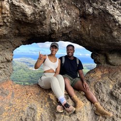
Went up last weekend for the third time. Our large hiking group had some experienced hiker familiar with 2 and 3 so seven of us decided to make the quest for all three peaks. Next level of quest fulfilled! Peak one is now fairly easy -- well, yeah it is a steep uphill hike but not difficult or scary. At the top of number one we debated going further -- and off we went to number two. That's a quick 10 minute hike down, then up to the summit of two. Once there we debated again about number three since we'd already committed to doing another hike that afternoon in Kaneohe. Seven of us decided to forgo our Kaneohe commitment and headed down for number three. Wow, it IS super steep going down from the summit of two. But there's good ropes available and we had fantastic spotters both at the top and bottom to guide us. Once you're past that section it's mostly uphill. The puka is steep and from there to the summit of three is quite steep as well. Lots of bouldering and some more ropes. I thought past the puka was not too difficult but it IS steep and you must pay attention and ALWAYS have three points of contact and NEVER EVER put your full weight on ANY of the ropes. Despite the hot and humid afternoon (by that time), we summited number three and had the summit to ourselves for a while. Absolutely beautiful atop all three peaks. Pictures simply do not do justice for this fantastic hike! Going back was easier and more comfortable since we'd already gone up the peaks and had some familiarity. Still, pay attention and always keep three points of contact on the mountain. Going back up to the second peak was still steep but seemed easier than going down. Spent a few minutes at the top of number one again, then headed down. All in all, it took us about 5 hours round trip to complete all three peaks with about an hour (total) atop the peaks. If you are thinking/planning of doing all three peaks, make sure of good weather with ZERO precipitation, wear good hiking boots, bring plenty of water, and have hikers with you that have already done all three peaks. It's super helpful to have experienced guides from peak two to three. Enjoy. read more


Such a fun hike. Walk past the golf course security and you'll see a sign for the trailhead on the left. The trail is mostly shady, which is nice. It's pretty steep and after a bit you'll get to some rocks to climb. Followed by ropes to climb up ! It's well secured, but not for everyone because it gets a little narrow with drop offs at the top. Bring water !! Really beautiful view and very fun, feels like an obstacle course. read more


9 years ago
The one tip I can give you is BRING WATER! My friend and I brought only 2 plastic bottles for the both of us and we only made it to the first peak. This hike is really fun, my favorite part was actually climbing the rocks. The view is incredible and worth it. I almost gave up because I was so tired but this random couple going down told me that I'm almost there. Need to get back in shape to do all three peaks! Park by Auloa Road. There should be an area on the right side where you can park your cars. You have to walk in the golf course, past the security and you will see an entrance on the right. Don't mind the security, they will let you in to hike before 3pm. read more

11 years ago
"You shall not live"...words of Palila Legend: Ahuapua, the King of Oahu was in fear of Olomana, who was a mighty man, famous for his great strength and height, standing some thirty feet plus. Olomana was the ruler/warrior of the windward side of Oahu. He declared it kapu from Makapu'u point to Ka'oio. This infuriated Ahuapua, but the king never ventured here for fear of Olomana. It must be tough being king? So, what to do? King Ahuapua sent message to Kaua'i and received the blessed warrior Palila... Present: Kyle: "You off Friday?" Me: "You know I am." Kyle: "Let's do Olomana." When I first moved to Oahu, I remember coming out of the second Pali tunnel with my then girlfriend, hitting the hair-pin turn and seeing Olomana's awesome presence and saying: "I'm gonna climb that!" We both laughed. Many years later, here I am. Kyle: "Let's do sunrise?" Me: "I've seen the sun come up before." Kyle: "Not from there!" 4:40am, I set in my car, in front of his house...waiting. Finally he comes out. Kyle: "..." Me: "Man, it's gonna be sloppy," (Having rained the night before). Kyle: "Yeah, I thought about that, you still game?" Me: "Hell yeah." I'll not tell you to not do this hike. I'll encourage you. This is no walk in the park hike, you will sweat buckets, you might gasp for breath, you might even lose confidence along the way and want to turn back. There are a couple of points where you might even say, "God, don't let me die here!"...you can do it. Up and down with thirty to forty minutes spent at the top...2 hours and thirty-five minutes. I have to many pics to post. The entrance is located just inside Luana Hills Golf Course. Take the back wall behind the guard shack and you'll see the path on the left over a finely trimmed hedge. You can park back up the road just before a small bridge on either the left or right side. Put all valuables in your trunk. Standard hiking gear needed, plus gloves, there are three sets of ropes. Head lamps if you come for sunrise. Legend: Palila having landed on Nuuanu cliff, spied Olomana standing at Ka'elepulu. Pulled by his magic Lei-o-Mano (Hawaiian war club) he landed on Olomana's shoulder: Olomana: "Where are you from, you most conceited boy? For my shoulder has never been stepped on by anybody, and here you have gone and done it." Palila: "I am from the kapued temple; from Alanapo in Humuula, Kaua'i. My name is Palila and I am a soldier." When Olomana heard this he was afraid and begged Palila that he be saved. Palila, however, refused saying..."You shall not live." Palila, in the vigorous battle of the club, slew Olomana by cutting him in half. Mount Olomana (divided hill) represents the severed body of Olomana. At the last, there is a five minute upward rock climb. Go straight up, as there is a false path leading to the right...don't follow this: Kyle: "I'm going on up to catch the sunrise." Me: "Fool, see that cloud cover? Ain't gonna be no sunrise." He went on and after a brief pause ;), I ventured (past the point where I should have started to climb) along the path. The trailhead began to narrow, and became a sliver of mud with a fifty foot drop along a shear rock wall: Me: "God, please, don't let me die today." I turned back and found the right way. On top, a halo rainbow appeared in the clouds covering Pail. I...am blessed. Today, I was Palila. Tomorrow, you can be. Mount Olomana is comprised of three different peaks, the first (and highest) being Olomana, the second is Paku'i and the last being Ahiki...the trail continues along to Ahiki, but I have yet to sample these...Yet. Aloha (The story of Palila/Olomana, and more can be found in Abraham Fornander's "Collection of Hawaiian Antiquities"...for the record). read more

 Aloha - Hiking Near Me - Kailua, Hawaii")


Is this hike hard? Yes. No. Maybe. Yes. Sorta. Lamp. What does it matter what I say? What if I'm in the worst shape of my life? What if I train with Navy Seals? Some say, there are no stupid questions. Well, "Is it hard?" is a stupid question. Try it, find out for yourself! If you have a real fear of heights, this hike may not be for you. There are some very steep parts and some light scrambling/climbing required. General Hike Times 1st Peak: 1.5 - 2:30 hrs roundtrip (approximately) 3rd Peak: 4 - 6 hrs roundtrip *not including the 10-15 min walk from parking area to the trail head. Car Break-in's There are a lot. Take your valuables. Peak 1 Wake up, Gluts and Quads! This sections will get your heart pumping, even at a moderate pace. Some steep sections, with ropes to help, and a few simple scrambles toward the top. If it's rainy, it'll be a pain in the ass, I've only hiked it when dry or a little damp. As everyone else will say, this peak has the most spectacular view. Your knees will hate you on the way down. Peak 2 Getting to peak 2 is a little farther than it looks, but it's also pretty easy. There's no reason not to go if you have the time. Going down the back side of peak 2 is where the challenge and fun begins. Much steeper with several ropes to help. REMINDER: Never rely 100% on a rope. These are not officially maintained by anyone. Use them for safety, and to help in hard parts. Otherwise, I try not to use them at all. Peak 3. Down peak 2 and up peak 3 are the most challenging and amazing parts of the hike. Not for the novice. Lots of climbing, though no climbing gear is needed. Take your time. Some parts require you to carefully plan your hand and foot holds. The rocks can be crumbly, I came across a few loose ones. When climbing, practice 3 points of contact, meaning, keep two hands and one foot, or two feet and one hand on the ground. Lastly, stay off your damn phone while you're moving! Common sense. Food & Water I recommend 2L+ even just for the first peak. I drink my entire 3L Camelbak every time. When I did all three peaks I drank the 3L plus 24oz of Gatorade. For 3rd peak, definitely have some grinds. Ropes I'll say it again, nobody officially maintains or checks the ropes that you'll find on this trail. Some are old, some deteriorating. Sometimes they are only tied to small tree roots that could easily one day come loose. Never put all your weight on these ropes. Shoes I wear Lowa Renegade GTX Mids. Maybe overkill. You'll see people with flimsy running shoes, vibrams, whatever. I'm just saying, I'll never wear anything less than a pair of hiking boots with excellent traction up here. Unless I go native an start hiking bare foot. Eh brah, wat?! Could happen! read more


11 years ago
This is a great hike for anyone looking for a challenge. Recommend going with someone who has tackled all three peaks, and also heading there early, sunrise would probably be nice. Overall: Difficulty: Novice-Advanced Length: 2-3mi Elevation: 1,000+ Duration: 1-6 hrs (based on hiking level, rest/picture stops) Apparel: Non-slip covered shoes, breathable fitted clothing To first peak: Difficulty: novice/intermediate hikers, older children Length: 1.5mi * About 1,000+ elevation gain on the way up so just take it slow, but try to stay out of the way for other hikers. * Well shaded To second peak: Difficulty: intermediate/advanced hikers, not good for kids Length: Short * No elevation gain, in fact lower than the first peak * Partially shaded * Very light rock climbing To third peak: Difficulty: Advanced hikers only Length: Short * No elevation gain * Not shaded * Moderate rock climbing, ropes provided but test your hold first, they might be old. I rely on good footing and roots. Always test your hold. * Narrow steep ridge & cliff/cliff face Full review: This was probably the scariest hike of my life. I spent about 2 years going from a 240lb nooooviceee hiker, with bad asthma (and I was a smoker), to a 135lb semi-advanced hiker, climbing rocks with ease without the use of ropes. Narrow ridge lines never stopped me. I spent those two years whooping my ass in shape and training for Koko head railway, Koko crater rim and at the top of my list? Pu`u Manamana & The three peaks of Olomana. Holy fartface. Because of the asthma & smoking doing steep inclines is extremely difficult for me. Getting to the first peak would have been a snap if my lungs weren't so sucky. So, yeah, I believe any novice hiker and even some kids can handle this. To the second peak is a little more challenging but fun for me as I really enjoy climbing rocks. It's a much shorter "hike" which my lungs appreciated. We took a nice long break on that peak as it had a great view and a really nice plateau to chill on. In fact, I ended up going back and forth between the first and second peak several times to find the stragglers in our group. Anyway, on all my first hikes I like to bring a Guinness, so we had ourselves a drink, and I kinda wish I hadn't done that. Because, here comes the third peak. What the hell was I thinking? You know, I saw some people climbing down the second peak and up the third peak like it was a brisk walk through the park. So I'm thinking, "No prob, Bob." We went with a group of first-timers; about 6 of us. Only one other, and myself, had the cojones to attempt it. Guess I wasn't as advanced as I thought. Getting down that second peak seemed to take me at least half an hour. I actually hate using rope so I tried to just cling onto anything, dear life?, to get down that...monstrosity. Then comes the third peak. It's all a blur to me, and unfortunately my GoPro died on my way down the second one so I'm a little foggy about this part of my experience. I just remember getting to this really narrow ledge that wraps around this big puka rock formation, where I actually lost my footing twice and nearly plummeted to my doom. I finally made it to the very top and almost died there as well. All I'm thinking is, "Please don't be that idiot that needs a rescue..." -- vain I know, but I'm just being honest. The hardest part of this hike for me was probably getting back up the second peak from the third. It's practically at a 90 degree angle (I might be exaggerating) so it's really hard work. I really worked my knees after that, zooming as fast as I could down the mountain and then running back to my car where we had a good make-out sesh (me and my car, Betsy) because I was so grateful to be done with it. I was so proud of myself, but also filled with the fear of the flying spaghetti monster. I don't know what this hike did to me, but I went from 4-5 hikes a week, sometimes two in one day, to one or two hikes every month. My heart is racing right now just trying to remember it. read more


12 years ago
My boyfriend and I are avid hikers. We knew we wanted our trip to Hawaii to be filled with lots of hiking and adventure (along with relaxing of course). We first stumbled upon the Olomana Trail on Tripadvisor. The picture of the 3 peaks was very alluring. We love hiking; we love climbing; we love awesome views-sweet! How bad could it be?! Oh boy... I wouldn't say we were in over our heads, but the trail was our most technical to date. I want to first start off by saying that we completed all 3 peaks, so this review is an overlook for the complete trail. I'll break up the trail in sections to help paint a better picture of the trail. To Peak 1 The first part of the trail was extremely muddy (because of tree cover and recent and current rain) and covered (very humid). There are a ton of tree roots which can be helpful or not depending on how carefully you're placing your footing. We found the edges of the trails to be the least muddiest to transverse through. After the tree covered part ends, the trail opens up into a dry red section. The fun begins after this section is complete. The infamous ropes and rocks the trail is all about. Very rocky, but fairly "easy" if you have some experience hiking and rock climbing/bouldering. There are ropes to assist you up some parts, but try not to use them. As other reviews have said, these ropes are old and are often frayed in some parts. Good footing and sturdy tree roots (pull hard before you rely on it) will be your best friends up. There are three sections with ropes with the last being the steepest (practically vertical). After making it over that last wall, it's a pretty easy walk to peak 1. Summit 1 literally took my breath away. There are beautiful lush green mountain ridges in one direction and clear blue oceans in the other. The weather is just perfect on top. Perfect place for a snack/lunch break. If your hike ends here, you've already accomplished a lot and received a fabulous prize! If you're extremely winded and felt it was very difficult, you should probably turn around. If you felt like going up the ridge/rocks did not present too much of a challenge, continue on! Peak 1 to bottom of Peak 2 Trail is exposed from this point forward. From peak 1 to the bottom of peak 2, it is very similar to the rocky part up to peak 1, except more steep. The whole trail down and up has ropes to assist you. There were times where I was going kind of fast and jumped off to patches of dirt that I thought were grippy but were slippery instead. Be careful with those patches. Bottom of peak 1 to the top of peak 2 is basically the same terrain/steepness as going down from peak 1. In my opinion, the summit of peak 2 was kind of forgettable. It still offers the 360 views you got earlier except this time you have peak 1 behind you and the beast of peak 3 staring you in the face. Peak 2 to Peak 3 Going up/down peak 3 is the most dangerous part of the trail. There are times where you're literally on the ledge of the ridge, scaling the rock wall to get across. There are vertical and steep parts with very few places to place your hands and feet. If you have any rock climbing or bouldering skills, this is the section where you'll utilize it the most. My adrenaline was pumping as I was going up, and especially down this section. There was one particular rock wall that I had a hard time getting down from (near the rock with the hole in it). The rock had sheer drops on both sides, and I couldn't find any secure places to place my feet and hands. My boyfriend had to help me down this part. Please listen to your body on this section of the trail. If you have a hard time getting up, you'll sure as hell have an even harder time getting down. The summit of peak 3 is satisfying for the fact that you did all three peaks. It was nice to look back on our accomplishment for the day. There is a ladder on summit 3 that goes down. The trail actually continues. We do not know where it goes. Despite the high risk factor of the trail, I would highly recommend it for the panoramic views and challenge. I loved all the natural beauty on and around the trail. The only part that posed a serious challenge to me was going up/down peak 3. So if you're a fairly experienced hiker with some climbing experience with good judgment, go for all 3! You will not regret it! Things to Bring -Snacks -Sunscreen -Bugspray (I didn't notice anything on the trail, but I got back with 8 bug bites- boyfriend none so variable) -Good hiking shoes (good grippy shoes will be your best friend; personally I do not think running/gym shoes will suffice) -Lots of water!! -Hiking buddy Physical Background I am 5ft and 105lbs. I walk stairs everyday for cardio. I hike a lot. For Californians and Bay Area residents, I have done Half Dome twice (easier compared to this trail) and can complete Mission Peak in Fremont in 1.5 hours. I can do 1's-2's bouldering read more


13 years ago
Olomana has been called 'the most dangerous trail on the island' by folks who aren't aware of the 100+ even more dangerous trails on O'ahu. There's a lot of hype surrounding this hike (specifically third peak), largely resulting from the handful of unfortunate and sometimes fatal falls which I think are directly related to the popularity of the trail. It is strange to me that this hike is typically as crowded as Mariner's Ridge, almost an exact opposite in terms of difficulty. But I digress. FIRST PEAK (OLOMANA) The route up to Olomana is a bun burner. You go from roughly 200 feet of elevation to 1,600 very quickly, and begin mild rope/rock climbing around 1,200 feet. Prior to the peak is the first boulder section. There is a rope, though it can be free-climbed. If it is your first trip here and you aren't comfortable with sheer drop offs on both sides, this section is a good litmus test for whether you should go further than second peak. After the boulder is a shorter boulder section. You can climb over or contour right, going right is definitely easier. This part of the trail seems mild but someone did fall here awhile back and found himself dangling off a cliff, waiting for rescue. Don't be too comfy. First peak is the tallest and will provide the best views, mostly because Ahiki is the most iconic and photogenic of the peaks, and you have the best view of it perched on Olomana. The mauka and makai views are the same on all three peaks, the elevation change doesn't make any material difference with regard to that view. SECOND PEAK (PAKU'I) The saddle between Olomana and Paku'i is short and sweet. There are drop offs on one or both sides at times. If this bothers you, turn around because it will not get better. Now to the fun stuff! Descending to the saddle between Paku'i and Ahiki is a several-hundred feet, 70-degree scramble. It is steep but there are ample foot and hand-holds, rope was in good condition (as of early April 2013) and there are no severe drops on either side. If you're with a group, go one at a time on the ropes to prevent covering the person below you with dust or disloding a heavy rock on them. The saddle between Paku'i and Ahiki gives you a nice break on somewhat flat-ground before the final climb. THIRD PEAK (AHIKI) Ascending third peak isn't a long journey, but you need to be careful. The jagged rocks offer plenty of nooks and crannies you can work your feet and fingers into, but take extra caution since the rock can crumble below your feet. There are only two or three narrow and steep sections and from what I recall none are taller than 20 feet, though they do have sheer drops on both sides. On the keyhole section (you'll know it when you see it), contour left and be careful of the sharp drop behind you. I would say that this hike wasn't as challenging as I anticipated, and it isn't as bad as it looks. The popular GoPro videos that everyone puts out use a fisheye effect to distort and make the trail look more and steep narrow than it really is. If you've researched this hike and find yourself discouraged by the videos, don't be. If you're an intermediate climber and have done some bouldering, this should be more fun than terrifying. That said, I saw a lot of nervous tourists descending second peak, shaking as they climbed down and stacked so tight they were kicking dust and rocks onto each other. If you're at all unsure of yourself, if you're nervous on the first boulder section, call it a day at peak 2 and come back after getting more experience elsewhere. Koko Crater's mauka rim is a good primer. Better not to end up on the news, though. Additional notes: - The path to third peak is nearly 4 miles roundtrip and took us (two intermediate hikers) 3.5 hours start to finish. Go as slow as you need to be comfortable. - The parking area is very high-theft. - Wear appropriate footwear since the rock can be sharp. I've seen slippers and even mocassins on this trail. Hiking boots might be hard to fit into certain areas, I felt good with trail running shoes. - There's almost no shade above 1,200 feet, so pack water accordingly. read more


8 years ago
Page 1 of 7
More info about Olomana Hike
770 Auloa Rd
Kailua, HI 96734
Directions
Visit Website
http://www.htmclub.org/trails/olomana.html
Hours
Indoor Amenities
Outdoor Amenities
Olomana Hike Reviews in Other Languages
Ask the Community - Olomana Hike
How long does the hike take?
I would say 3-4 hours but if you guys are fast you can reach to the top in one hour.
Review Highlights - Olomana Hike
You might also consider


Why does Yelp recommend reviews?
8 reviews that are not currently recommended
The reviews below are not factored into the business's overall star rating.
9 years ago
13 years ago
8 years ago
9 years ago
6 years ago
11 years ago
13 years ago
13 years ago
Olomana Hike - hiking - Updated June 2026
Best of Kailua
People found Olomana Hike by searching for…
Things to Do in Kailua, Hawaii
Hiking Trails in Kailua, Hawaii
Waterfall Hike in Kailua, Hawaii
Rock Climbing in Kailua, Hawaii
Bamboo Forest in Kailua, Hawaii
Abandoned Buildings in Kailua, Hawaii
Dog Friendly Hiking Trails in Kailua, Hawaii
Fishing Spots in Kailua, Hawaii
Running Trails in Kailua, Hawaii
Abandoned Places in Kailua, Hawaii
Dog Friendly Beaches in Kailua, Hawaii
Trending Searches in Kailua, HI
Amusement Parks near Olomana Hike
Bird Sanctuary near Olomana Hike
Cliff Jumping near Olomana Hike
Dog Friendly Things To Do near Olomana Hike
Fishing Spots near Olomana Hike
Free Kids Activities near Olomana Hike
Jet Ski Rental near Olomana Hike
Outdoor Activities near Olomana Hike
Public Pools near Olomana Hike
Public Shower near Olomana Hike
River Swimming near Olomana Hike
Running Trails near Olomana Hike
Scenic Drive near Olomana Hike
Secluded Spots near Olomana Hike
Soccer Store near Olomana Hike
Strawberry Picking near Olomana Hike
Sunrise View near Olomana Hike
Swimming Holes near Olomana Hike
Swimming Lakes near Olomana Hike
Swimming Pools near Olomana Hike
Browse Articles
Browse Nearby
BEST of Kailua, Hawaii Coffee near Olomana Hike
BEST of Kailua, Hawaii Things to Do near Olomana Hike
BEST of Kailua, Hawaii Restaurants near Olomana Hike
BEST of Kailua, Hawaii Breakfast near Olomana Hike
BEST of Kailua, Hawaii Walking Trails near Olomana Hike
BEST of Kailua, Hawaii Campgrounds near Olomana Hike
BEST of Kailua, Hawaii Parks near Olomana Hike
Browse Brands
Related Searches in Kailua, HI
Affordable Kayak Rental Services in Kailua, Hawaii
Best Fishing Locations and Guides in Kailua, Hawaii
Best Nature Trails for Hiking in Kailua, Hawaii
Best Places for Horseback Riding in Kailua, Hawaii
Best Waterfalls and Swimming Holes in Kailua, Hawaii
Check Out Off Road Trails in Kailua, Hawaii
Discover Dog Friendly Trails to Explore in Kailua, Hawaii
Discover Kid Friendly Hiking Trails in Kailua, Hawaii
Discover Scenic Hiking Trails in Kailua, Hawaii
Discover Scenic Waterfall Spots in Kailua, Hawaii
Discover Top Nature Parks to Visit in Kailua, Hawaii
Discover Walking Parks in Kailua, Hawaii Near You
Discover a Hiking Trail in Kailua, Hawaii
Discover the Best Night Hike Trails in Kailua, Hawaii
Enjoy Camping Adventures Around Kailua, Hawaii
Enjoy Kayaking Adventures in Kailua, Hawaii
Enjoy Tent Camping Spots Around Kailua, Hawaii
Enjoy a Beautiful Waterfall Hike in Kailua, Hawaii
Enjoy a Peaceful Nature Walk in Kailua, Hawaii
Enjoy the Best Picnic Spots and Ideas in Kailua, Hawaii
Enjoy the Best Walking Path in Kailua, Hawaii
Enjoy the Best Walking Trails in Kailua, Hawaii
Exciting Cliff Jumping Spots in Kailua, Hawaii
Explore Beautiful Parks and Green Spaces in Kailua, Hawaii
Explore Easy Hikes Perfect for All in Kailua, Hawaii
Explore Fun Activities to Do in Kailua, Hawaii
Explore Popular Campgrounds Near Kailua, Hawaii
Explore the Best Beach Spots in Kailua, Hawaii
Explore the Best Swimming Holes Around Kailua, Hawaii
Explore the Best Trail Options in Kailua, Hawaii
Family Friendly Hiking With Kids in Kailua, Hawaii
Find Beautiful Views in Kailua, Hawaii
Find Popular Ziplining Spots Around Kailua, Hawaii
Find the Best Parks for Picnics in Kailua, Hawaii
Find the Best Scenic View Locations in Kailua, Hawaii
Great Places to Walk in Kailua, Hawaii
Hike the Popular Waterfall Trail in Kailua, Hawaii
Hiking Trails With Waterfalls in Kailua, Hawaii
Plan a Scenic Drive Route Near Kailua, Hawaii
Popular Outdoor Activities to Try in Kailua, Hawaii
Popular Picnic Spots to Visit in Kailua, Hawaii
Safe River Swimming Areas in Kailua, Hawaii
Safe and Fun Parks for Kids in Kailua, Hawaii
Top Climbing Spots and Gyms in Kailua, Hawaii
Top Paddleboarding Activities in Kailua, Hawaii
Top Places for Snorkeling in Kailua, Hawaii
Top Running Trails to Explore in Kailua, Hawaii
Top Swimming Spots and Pools in Kailua, Hawaii