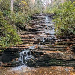
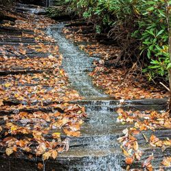
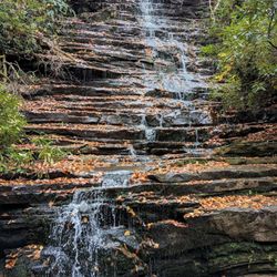
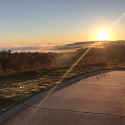
Panther Creek Recreation Area Photos


More like Panther Creek Recreation Area
Recommended Reviews - Panther Creek Recreation Area
Start your review...

Reviews With Photos

We parked our car on the street and got back after dark around 9pm. Make sure to take a headlamp if going back to the falls late. This was a very technical trail with roots and rocks all along the trail. My wife almost fractured he ankle on the way back so we took it easy after that happened. A group of 3 people that had passed us hiking back to the trailhead got slowed down also because one of them twisted their ankle also. You have to pay attention with eyes to the ground most of the time. If you're not good at this it's best for you to just stop to take in the scenery so you don't get injured. The falls were beautiful! It was a bit crowded but not too bad. This would be a great hike out and camp spot but make sure to set your tent downstream from the falls so you're not interrupted by visitors. Excellent trail all in all!

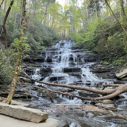
Wanderlust-er. Hike this now. Panther Creek Falls' seven-mile (3.5 there and back) trail ranks as my favorite hike in Georgia. Physically, mentally, and spiritually challenging? Check. Hovering/ Lord of the Ring-talking trees? Possibly. Stunning, bathe-worthy waterfall ideal for the summertime and bombing your friends' Instagram feeds? YES. Going now? Nice! Things to know: ***** I. LOGISTICS: - Being from Atlanta, the drive from Atlanta is about 2.5 hours (and worth it every time). - It's a bit dangerous when wet (that's what she said). Check the weather, often, before your planned hike. - Consider downloading an offline map to account for spotty cell phone service. - Parking outside of the entrance is free (and on the highway). - Hiking alone took a bit more than an hour and a half each way. Plan on spending at least an hour or two at the waterfall, too. II. RECOMMENDED CLOTHING & EQUIPMENT: - Tennis shoes with grip or hiking boots. - A liter or two of water. - A bathing suit. - Small/ medium-sized towel. - Snacks. III. THE TRAIL: I think of it in three parts: PART I: The first "section" has somewhat challenging changes in elevation, and it runs high above the river. Know that there will be times where you'll have to climb a few steep rocks. If you're not somewhat fit, be prepared! Also, watch out for the roots protruding from the ground. One snag may cause serious injury. PART II: The trail becomes mostly flat making it easy to hike (while hugging the river). This section seems to last forever, but once you start ascending in elevation, know you're getting closer to Part III. PART III: The trail then becomes a bit more treacherous. You'll hike up cliffsides with guard rails, which don't look safe. (They're barely adequate.) Then you'll steeply descend/ climb down rocks into Panther Creek Falls. You're probably going to use your hands a bit here. Be prepared to get dirty! ABOUT THE FALLS: This breathtaking, three-to-four story high waterfall will make you smile. I suggest getting buck-naki behind a tree, throwing on your swimsuit, and bathing underneath this sucker. There's also a beautiful pool of water ideal for swimming. Take all the time you want there. You deserve it, hiker, you. OVERALL: Panther Creek Falls is ideal for anyone looking for a serious workout or who considers themselves a waterfall chaser. I'd do this hike every week if I lived in the north part of Georiga.

I've always wanted to go to Panther Creek Falls from looking at Instagram photos. I was up for the challenge but little did I know how much more difficult it was than I thought. It is mostly due to the wet grounds, slippery rock surfaces, big tree roots, and narrow passage ways. I had to put my phone away in my back pack, just in case my clumsy self dropped it 10 ft deep when hiking up the narrow, tree rooted passage ways. Overall, it is not a difficult hike.....but only towards the end. Plus factor in the day we went. A day (or two) after rain, colder weather, and on top of that, it started raining on the way back. I wouldn't recommend young kids to come on the hike. When I say this, I am thinking about my friends with young kids who run around and need supervision. This ain't no state park with paved sidewalks. You might as well go to Anna Ruby Falls for that. Usually when I go hiking, the walk on the way back is usually faster but not at Panther Creek Falls. Maybe it is due to the fact that it was still raining and wasn't going to stop. I am glad it wasn't a monsoon but being wet and cold was not very comfortable. I am very very very grateful for Richard R & Jamarcus T for organizing the Off the Grid Hiking Trip #3. Without the guys who have been here numerous times before, being great hosts and guides, I do not think I would have enjoyed it as much. Plus I got to see great pics taken during the trip with a DSLR. Thank you Richard! I am glad I came. Panther Creek Falls is checked off my Georgia waterfall hiking bucket list! 2017 Review #18

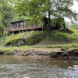
I've been on this trail a few times (6+) and I thought I could handle its difficulty after being abroad for a year, but I was kinda wrong. I guess I lost my badass hiking skills after not hiking for a year. I slipped twice, got some bruises and scratches, but I did manage to finish the hike in 2 hours and 30 minutes (1 hour and 15 minutes per way). I always go on the 3.5 mile trail on way to the waterfall and back since there is a lack of visible trail after that point since not many hike further to the dam. THE TRAIL: At the beginning, the trail is somewhat narrow with inclines and declines throughout. But, it gets more spacious and easier once you see the first bridge. There are four small bridges on the trail and if you stumble upon the first one after 30 minutes in, the trail gets easier. But, after the fourth bridge, it gets pretty intense. Because of the weather and natural degradation, you'll notice that some railings may have been damaged due to fallen trees. So, be cautious. I went when it rained the day before, so it was moist and slippery in certain areas---which was why I fell twice. In terms of difficulty, it's moderate but there are definitely some rough spots that you have to overcome. PARKING: If you want to avoid paying the parking fees of $3, park near the sign to the entrance of the road or on both sides of the road. Don't go and park inside. REST AREA: There are no official benches or tables for you to rest at, but you can sit along some rocks, watch the water runs through the stream and rehydrate or have a picnic. You can also camp here, which I've done before. WATERFALLS: There are a few waterfalls leading up to the big one at the end of the 3.5 mile and when you're there, you can swim, camp, eat, and explore the area. But if you do decide to spend the night there, bring blankets because it got super cold once the sun sets--even when it's in the middle of the summer and super hot during the day. Overall, this trail sparked my love for hiking, so I definitely recommend this for anyone who loves nature and hiking.

Went here with a group of friends after we failed to get Tallulah Gorge passes (Gorge Floor Passes) at nearby Tallulah Gorge State Park. We were told our best bet for next time was to come on a week day for greatest chance to get a pass. Panther Creek Hiking Trail is nearby and a great alternate option in the event you cannot get the Gorge Floor Pass at Tallulah Gorge State Park. Panther Creek Hiking Trail is a challenging hike to be sure; however, it is also a great trail with beautiful water falls (for swimming / wading) at the end. Friends of mine have camped alongside the trail overnight. You park in the lot on one side of the highway and cross the highway to get to the trail entrance. At the trail entrance you will see the sign which reads that the Panther Creek Hiking Trail is 3.5 miles to the falls and 3.5 miles back. You have some steep hilly climbs with a few flat stretches along the creek. There are a plethora of reviews here (and Stephie Z's in particular is accurate and typical ) so I'm not going to go into much more detail. Many other reviewers have already written about the warnings regarding how treacherous some areas of this trail are. Also note that many parts of the trail are moderately difficult to traverse. You really have to be in good physical shape! Plan on two plus hours in and two plus hours to get back out. You need good trail running shoes or light hiking boots; Many stretches of the trail require crossing streams with wet stones and rock cliff outcroppings. The hilly parts have protruding tree roots and many stretches require stooping, grasping and very careful foot placement. Some surfaces become very slippery if the rocks are wet from rain or water runoff. The trail gets very steep in quite a few places. I would say this trail is not a good trail for older dogs or small children. The trail is definitely not good for geriatric adults either or those adults who are not in good physical / athletic shape. Panther Creek Hiking Trail is definitely not good for those afraid of heights (as parts of this trail contain precipices that are very steep and there are many drop-offs to consider). Otherwise take it for what it is; a stunning piece of Georgia nature. Perhaps really deserves 5 stars; however, due to the challenging nature that this trail presents for some. I am going to dispense 4stars (I doubt this will hurt them).

Normally, I hike the AT, but decided to go to a new place for an easy day hike. The waterfall was an awesome change from my normal hikes. I suggest bringing lunch, your dog, bathing suit, and a towel especially since summer is here. You can easily enjoy a few hours here before you hike back. It's a pretty easy hike about 3-4 on a scale of 10.

Awesome hike!! I found this hike as we were taking a road trip through the U.S. (On Yelp). I'm always excited when the hike has a waterfall at the end to look forward to! I believe the hike was 7.5 miles or 8 miles round trip which wasn't bad at all. It was a little humid, but we didn't mind. The trails are heavily trafficked, you can't really get lost if you follow the trail... GREAT HIKE, with a WATERFALL!

One of my favorite day hikes! Panther Creek Falls is about 1 1/2 hours from downtown Atlanta. Head north up 85, then bear left onto 985 towards Gainseville and Tallulah Falls. 985 will eventually turn into 441. After about 45 minutes on 985 look for a Kangaroo gas station on your left. About 3 or 4 streets after that will be Travis Smith Rd. Turn left on to Travis Smith. Make your first and only right onto Old Hwy 441 and less than 1 mile down on your left you will see Panther Creek Recreation Area. Park in the lot (there are bathrooms there). Then walk back out and cross 441. The trail head starts across the street- you will see a sign for Panther Creek Falls. The reasons to hike this trail are A) it's gorgeous B) there are large falls at the end and C) you can swim in the bottom of the falls. I would consider the trail to be of moderate difficulty. I have seen plenty of older folks hiking so I don't think it is too tough, but right before the falls there are some pretty heavy rock areas that you have to scramble over and some sharp drop offs where you will want to pay great attention to where you put your feet. Oh and make sure you follow the green blazes. The trail to the falls is about 3.5 miles so keep in mind it is 7 miles total to get there and back. Not that tough, but plan for the hike taking several hours. The first part of the trail isn't very scenic. You walk through some scrub and under the 441 overpass. Don't let this fool you, you quickly make it into the woods where there are lots of easy up and down switchbacks. They will have you breathing heavy on the way out. You will then begin following the river providing for plenty of beautiful views. This trail is okay for dogs as long as you pay attention to where they are at and keep them leashed. There are some areas you might have to help them up and over. At about the 1.4 mile mark you will be right next to the stream and need to cross your first bridge. Don't worry, it's small. Now you will begin hiking next to the river and through a flat sandy trail. The river is pretty calm here. Again make sure you follow the green blazes. There was one part of the trail that wasn't well marked and a second trail broke off. (2 miles or so in) Go to the left, towards the river. *Remember this entire trail follows the river so if you are near to it, you are on the right path.* There are 2 more bridges to cross and tiny stream with rock stepping stones to "forge" before you get to your first steep "scramble". There are metal poles and guidewire here, but be careful since some of the poles have come loose from their mooring. You'll reach the upper falls at 3.4 miles and think you are there. Here will be more areas where you might have to get on your butt and maneuver, it's really steep and you want to be careful. Again the poles and guidewire haven't been maintained in some time so pay attention. You will then make it to the bottom of the falls where there is a nice flat sandy area. You can stop, take pictures, eat lunch, swim, do whatever. It is beautiful. You will probably not be the only one at the falls; it's pretty popular. Once your done admiring nature's beauty, rinse and repeat- go back the way you came in...and make sure you carry all your trash out. All in all a great hike that lends it's self to some fabulous pictures.

I loved our visit to panther creek falls. I read a lot of the yelp reviews and I have to say I agree with some things, some things I dont. So here is my perspective to add to the considerations before visiting 1. stamina- this trail whether you stay on the trail (or venture off for a harder challenge) you need good stamina. If you cant walk 7-8 miles flat, dont even bother this. You wont enjoy your walk despite how beautiful the scenery is. You need energy for 6 hours roughly. 2. Bathroom- go before, there is no where to go unless you wanna go in the water lol 3. Water/food - bring water and food, no where to buy any (seriously, someone should sell water and food down at the end- they would make a good few bucks!) 4. Shoes/clothing - I see so many old people exaggerating by having hiking backpacks, poles, hiking boots and saying this trail isnt for kids and yada yada yada.......seriously, you dont need it and its a waste to us young folks. If you stay on the easy trail you can go in flip flops (most of us did) with a water bottle in hand. There were a tons of kids and dogs. Anyone can hike here! 5. Trail Level- higher up trail is easier and quicker. Lower down where you get to see 3-5 waterfalls in total is a longer and harder trail......or maybe we just got lost. But our dog did it so no excuses! You have to definetly grab some roots and jump a lot to get around like a rock climber but its more fun for sure and rewarding. The waterfall is beautiful and very rewarding. I say totally worth going here once.

A rock solid 5 stars all the way! This trail is just what I was looking for in getting some exercise, being outdoors and enjoying some beautiful scenery. The cost is only $3 bucks to get park and access the trail and there was ample parking. The trail is a definite moderate rating. Very rooty and rocky in some places. Please be careful as other reviews say. Sure footing is a must. There are several steep drop offs that could land you in the creek! Dogs and kids both should be leashed! There is several back country camp sites all along the trail. The scenery is awesome too. Several waterfalls, shoals and rock outcroppings. Beautiful waterfalls at the end. Make sure you take your time and allow plenty of time so you dont get stuck in the dark!! Go, go, go! You wont be dissapointed!

7 months ago
Overall great hike. A few steep sections but nothing too crazy. Beautiful scenery the whole way. Would recommend for anyone looking for a solid outdoor experience. read more


My partner and I recently visited Clarksville for a spontaneous hiking trip. Panther Creek Trail was at the very top of our list and we were not disappointed. At first we were worried that the trail would be closed due to the storm damage that occurred during the prior year but we drove by and there were multiple parties going in and out of the trail so we figured we would go for it! This trail is long and arduous, so be prepared! Us Floridians definitely overestimated our hiking abilities but we still got it done (thankfully). Bring around 2L per person or more if it's a hot day. We started on a Friday around 2pm and finished by 6:30pm and clocked in a total of 8 miles round trip. If you can go earlier, I highly recommend doing so to have plenty of light. There's two main parts of the trail where the bridges were damaged and removed. In one section, there's several logs that lay across the stream. Find a big stick, and scramble across. In the second section, the water is shallow enough to walk across without the possibility of getting your legs wet. But even if you get wet, both sections are not deeper than your ankle. I don't know if I'd recommend this for children as there are multiple sudden drop offs but more power to you if your family can do this! If you are a hiker, this does not disappoint! read more


6 years ago
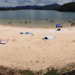
UPDATE - 3/21/2020 HIKE The trail has been greatly improved with the construction of new stone stairs leading to the base of the falls AND a new route that takes you much more safely around the big stone outcrop overlooking the cascades above the falls. The descent to the base was once so bad that my wife refused to try (twice). This hike was the 1st time she ever made it all the way down. ALSO, they cleared many areas of heavy brush (especially at the beginning of the hike) and opened up other areas along the river. There were at least two areas perfect for photos that I don't remember being there on previous hikes. I was VERY IMPRESSED with the work they put into these improvements. There are still a few treacherous areas that could desperately use railing, but overall the changes make a big difference!!! ~~~ PREVIOUS REVIEW [modified] Looking for a challenging yet rewarding hike? Panther Creek is a calorie burner for sure!!! At 7 miles round trip, it is a fairly moderate hike to the falls as you scramble over roots, rocks, overgrowth and other hazards along the trail. But but once you cross the bridge to the other side of the creek, it gets much smoother until it begins to elevate near the falls. The hike back to the parking area will be far more of a workout and proved to be a bit tougher in reverse. Since my first visit in 2013, the trail has gotten extremely popular. I would often only see a handful of people at the falls or along the trail back then, but it has become incredibly crowded since. The crowd at the falls can easily reach 60 to 100 people on a hot summer Saturday... not counting the various full campsites along the way. Many trail repairs that I complained about in my previous review have been made, but still improvements on the narrow steep cliffs could use some work. However, in one of the most dangerous sections of the trail where there is a cliff side drop of 25+ feet, the railing is holding strong. ~~~ STATS AT A GLANCE: Hiking Distance - 7 miles (roundtrip) Difficulty - 4 out of 10 Bridged Crossings - 4 + a few small wet streams Hike time - 1.5 to 2 hours each way depending on your stamina Elevation Gain: 200+ feet Waterfall Height: 40' approx Access to top of falls: YES Access to base of falls: YES Pool of water @ base of falls: YES Sitting Area @ base: YES + beach & huge camping area Camping areas: Several along trail RESTROOMS: YES @ parking PARKING: YES (40+ cars) [ NOTES ] * Can get very very crowded on the weekends, so come early. * Can be muddy & slippery in areas * Trail continues beyond the falls all the way to Yona Dam. However, this section of the trail adds 4.7 miles round trip and is rated difficult and far less maintained. I hiked about half a mile of it before turning back due to extreme overgrowth and fear of injury on this less populated route. * Good sized parking lot, but not for its popularity. Get there early or park along the road. [ THINGS TO SEE ] * Stone cliffs, cave like indentations in rock, river views, lots of flora and of course a gorgeous waterfall said to be created by the fault line it sits on. * Other Photo Op's - Be sure to stop at the area just above the falls for a picturesque view of the cascades. There are several gorgeous cascades and points of interest along the creek. * Beautiful cascade near the parking area perfect to decompress from the long hike. * There is a large secret waterfall off one of the tributaries that I hope to find and report soon ;-) ~~~ FINAL THOUGHTS Panther Creek Falls has it all!!! A trail that gives you a great workout, beautiful scenic views, a beach, parking w/restrooms and one of the most beautiful heavy flow waterfalls in all of Georgia! The improvements on the descent to the base make this a winner again, but other trail improvements are still much needed. Some cliff-side drops are near slippery, muddy areas and extreme caution should be taken, especially with children. 2020 / 20 read more


We parked our car on the street and got back after dark around 9pm. Make sure to take a headlamp if going back to the falls late. This was a very technical trail with roots and rocks all along the trail. My wife almost fractured he ankle on the way back so we took it easy after that happened. A group of 3 people that had passed us hiking back to the trailhead got slowed down also because one of them twisted their ankle also. You have to pay attention with eyes to the ground most of the time. If you're not good at this it's best for you to just stop to take in the scenery so you don't get injured. The falls were beautiful! It was a bit crowded but not too bad. This would be a great hike out and camp spot but make sure to set your tent downstream from the falls so you're not interrupted by visitors. Excellent trail all in all! read more


4 years ago
9 years ago
Wanderlust-er. Hike this now. Panther Creek Falls' seven-mile (3.5 there and back) trail ranks as my favorite hike in Georgia. Physically, mentally, and spiritually challenging? Check. Hovering/ Lord of the Ring-talking trees? Possibly. Stunning, bathe-worthy waterfall ideal for the summertime and bombing your friends' Instagram feeds? YES. Going now? Nice! Things to know: ***** I. LOGISTICS: - Being from Atlanta, the drive from Atlanta is about 2.5 hours (and worth it every time). - It's a bit dangerous when wet (that's what she said). Check the weather, often, before your planned hike. - Consider downloading an offline map to account for spotty cell phone service. - Parking outside of the entrance is free (and on the highway). - Hiking alone took a bit more than an hour and a half each way. Plan on spending at least an hour or two at the waterfall, too. II. RECOMMENDED CLOTHING & EQUIPMENT: - Tennis shoes with grip or hiking boots. - A liter or two of water. - A bathing suit. - Small/ medium-sized towel. - Snacks. III. THE TRAIL: I think of it in three parts: PART I: The first "section" has somewhat challenging changes in elevation, and it runs high above the river. Know that there will be times where you'll have to climb a few steep rocks. If you're not somewhat fit, be prepared! Also, watch out for the roots protruding from the ground. One snag may cause serious injury. PART II: The trail becomes mostly flat making it easy to hike (while hugging the river). This section seems to last forever, but once you start ascending in elevation, know you're getting closer to Part III. PART III: The trail then becomes a bit more treacherous. You'll hike up cliffsides with guard rails, which don't look safe. (They're barely adequate.) Then you'll steeply descend/ climb down rocks into Panther Creek Falls. You're probably going to use your hands a bit here. Be prepared to get dirty! ABOUT THE FALLS: This breathtaking, three-to-four story high waterfall will make you smile. I suggest getting buck-naki behind a tree, throwing on your swimsuit, and bathing underneath this sucker. There's also a beautiful pool of water ideal for swimming. Take all the time you want there. You deserve it, hiker, you. OVERALL: Panther Creek Falls is ideal for anyone looking for a serious workout or who considers themselves a waterfall chaser. I'd do this hike every week if I lived in the north part of Georiga. read more


I've always wanted to go to Panther Creek Falls from looking at Instagram photos. I was up for the challenge but little did I know how much more difficult it was than I thought. It is mostly due to the wet grounds, slippery rock surfaces, big tree roots, and narrow passage ways. I had to put my phone away in my back pack, just in case my clumsy self dropped it 10 ft deep when hiking up the narrow, tree rooted passage ways. Overall, it is not a difficult hike.....but only towards the end. Plus factor in the day we went. A day (or two) after rain, colder weather, and on top of that, it started raining on the way back. I wouldn't recommend young kids to come on the hike. When I say this, I am thinking about my friends with young kids who run around and need supervision. This ain't no state park with paved sidewalks. You might as well go to Anna Ruby Falls for that. Usually when I go hiking, the walk on the way back is usually faster but not at Panther Creek Falls. Maybe it is due to the fact that it was still raining and wasn't going to stop. I am glad it wasn't a monsoon but being wet and cold was not very comfortable. I am very very very grateful for Richard R & Jamarcus T for organizing the Off the Grid Hiking Trip #3. Without the guys who have been here numerous times before, being great hosts and guides, I do not think I would have enjoyed it as much. Plus I got to see great pics taken during the trip with a DSLR. Thank you Richard! I am glad I came. Panther Creek Falls is checked off my Georgia waterfall hiking bucket list! 2017 Review #18 read more


13 years ago
I've been on this trail a few times (6+) and I thought I could handle its difficulty after being abroad for a year, but I was kinda wrong. I guess I lost my badass hiking skills after not hiking for a year. I slipped twice, got some bruises and scratches, but I did manage to finish the hike in 2 hours and 30 minutes (1 hour and 15 minutes per way). I always go on the 3.5 mile trail on way to the waterfall and back since there is a lack of visible trail after that point since not many hike further to the dam. THE TRAIL: At the beginning, the trail is somewhat narrow with inclines and declines throughout. But, it gets more spacious and easier once you see the first bridge. There are four small bridges on the trail and if you stumble upon the first one after 30 minutes in, the trail gets easier. But, after the fourth bridge, it gets pretty intense. Because of the weather and natural degradation, you'll notice that some railings may have been damaged due to fallen trees. So, be cautious. I went when it rained the day before, so it was moist and slippery in certain areas---which was why I fell twice. In terms of difficulty, it's moderate but there are definitely some rough spots that you have to overcome. PARKING: If you want to avoid paying the parking fees of $3, park near the sign to the entrance of the road or on both sides of the road. Don't go and park inside. REST AREA: There are no official benches or tables for you to rest at, but you can sit along some rocks, watch the water runs through the stream and rehydrate or have a picnic. You can also camp here, which I've done before. WATERFALLS: There are a few waterfalls leading up to the big one at the end of the 3.5 mile and when you're there, you can swim, camp, eat, and explore the area. But if you do decide to spend the night there, bring blankets because it got super cold once the sun sets--even when it's in the middle of the summer and super hot during the day. Overall, this trail sparked my love for hiking, so I definitely recommend this for anyone who loves nature and hiking. read more


Went here with a group of friends after we failed to get Tallulah Gorge passes (Gorge Floor Passes) at nearby Tallulah Gorge State Park. We were told our best bet for next time was to come on a week day for greatest chance to get a pass. Panther Creek Hiking Trail is nearby and a great alternate option in the event you cannot get the Gorge Floor Pass at Tallulah Gorge State Park. Panther Creek Hiking Trail is a challenging hike to be sure; however, it is also a great trail with beautiful water falls (for swimming / wading) at the end. Friends of mine have camped alongside the trail overnight. You park in the lot on one side of the highway and cross the highway to get to the trail entrance. At the trail entrance you will see the sign which reads that the Panther Creek Hiking Trail is 3.5 miles to the falls and 3.5 miles back. You have some steep hilly climbs with a few flat stretches along the creek. There are a plethora of reviews here (and Stephie Z's in particular is accurate and typical ) so I'm not going to go into much more detail. Many other reviewers have already written about the warnings regarding how treacherous some areas of this trail are. Also note that many parts of the trail are moderately difficult to traverse. You really have to be in good physical shape! Plan on two plus hours in and two plus hours to get back out. You need good trail running shoes or light hiking boots; Many stretches of the trail require crossing streams with wet stones and rock cliff outcroppings. The hilly parts have protruding tree roots and many stretches require stooping, grasping and very careful foot placement. Some surfaces become very slippery if the rocks are wet from rain or water runoff. The trail gets very steep in quite a few places. I would say this trail is not a good trail for older dogs or small children. The trail is definitely not good for geriatric adults either or those adults who are not in good physical / athletic shape. Panther Creek Hiking Trail is definitely not good for those afraid of heights (as parts of this trail contain precipices that are very steep and there are many drop-offs to consider). Otherwise take it for what it is; a stunning piece of Georgia nature. Perhaps really deserves 5 stars; however, due to the challenging nature that this trail presents for some. I am going to dispense 4stars (I doubt this will hurt them). read more


7 years ago
12 years ago
Normally, I hike the AT, but decided to go to a new place for an easy day hike. The waterfall was an awesome change from my normal hikes. I suggest bringing lunch, your dog, bathing suit, and a towel especially since summer is here. You can easily enjoy a few hours here before you hike back. It's a pretty easy hike about 3-4 on a scale of 10. read more


Awesome hike!! I found this hike as we were taking a road trip through the U.S. (On Yelp). I'm always excited when the hike has a waterfall at the end to look forward to! I believe the hike was 7.5 miles or 8 miles round trip which wasn't bad at all. It was a little humid, but we didn't mind. The trails are heavily trafficked, you can't really get lost if you follow the trail... GREAT HIKE, with a WATERFALL! read more

14 years ago
One of my favorite day hikes! Panther Creek Falls is about 1 1/2 hours from downtown Atlanta. Head north up 85, then bear left onto 985 towards Gainseville and Tallulah Falls. 985 will eventually turn into 441. After about 45 minutes on 985 look for a Kangaroo gas station on your left. About 3 or 4 streets after that will be Travis Smith Rd. Turn left on to Travis Smith. Make your first and only right onto Old Hwy 441 and less than 1 mile down on your left you will see Panther Creek Recreation Area. Park in the lot (there are bathrooms there). Then walk back out and cross 441. The trail head starts across the street- you will see a sign for Panther Creek Falls. The reasons to hike this trail are A) it's gorgeous B) there are large falls at the end and C) you can swim in the bottom of the falls. I would consider the trail to be of moderate difficulty. I have seen plenty of older folks hiking so I don't think it is too tough, but right before the falls there are some pretty heavy rock areas that you have to scramble over and some sharp drop offs where you will want to pay great attention to where you put your feet. Oh and make sure you follow the green blazes. The trail to the falls is about 3.5 miles so keep in mind it is 7 miles total to get there and back. Not that tough, but plan for the hike taking several hours. The first part of the trail isn't very scenic. You walk through some scrub and under the 441 overpass. Don't let this fool you, you quickly make it into the woods where there are lots of easy up and down switchbacks. They will have you breathing heavy on the way out. You will then begin following the river providing for plenty of beautiful views. This trail is okay for dogs as long as you pay attention to where they are at and keep them leashed. There are some areas you might have to help them up and over. At about the 1.4 mile mark you will be right next to the stream and need to cross your first bridge. Don't worry, it's small. Now you will begin hiking next to the river and through a flat sandy trail. The river is pretty calm here. Again make sure you follow the green blazes. There was one part of the trail that wasn't well marked and a second trail broke off. (2 miles or so in) Go to the left, towards the river. *Remember this entire trail follows the river so if you are near to it, you are on the right path.* There are 2 more bridges to cross and tiny stream with rock stepping stones to "forge" before you get to your first steep "scramble". There are metal poles and guidewire here, but be careful since some of the poles have come loose from their mooring. You'll reach the upper falls at 3.4 miles and think you are there. Here will be more areas where you might have to get on your butt and maneuver, it's really steep and you want to be careful. Again the poles and guidewire haven't been maintained in some time so pay attention. You will then make it to the bottom of the falls where there is a nice flat sandy area. You can stop, take pictures, eat lunch, swim, do whatever. It is beautiful. You will probably not be the only one at the falls; it's pretty popular. Once your done admiring nature's beauty, rinse and repeat- go back the way you came in...and make sure you carry all your trash out. All in all a great hike that lends it's self to some fabulous pictures. read more

I loved our visit to panther creek falls. I read a lot of the yelp reviews and I have to say I agree with some things, some things I dont. So here is my perspective to add to the considerations before visiting 1. stamina- this trail whether you stay on the trail (or venture off for a harder challenge) you need good stamina. If you cant walk 7-8 miles flat, dont even bother this. You wont enjoy your walk despite how beautiful the scenery is. You need energy for 6 hours roughly. 2. Bathroom- go before, there is no where to go unless you wanna go in the water lol 3. Water/food - bring water and food, no where to buy any (seriously, someone should sell water and food down at the end- they would make a good few bucks!) 4. Shoes/clothing - I see so many old people exaggerating by having hiking backpacks, poles, hiking boots and saying this trail isnt for kids and yada yada yada.......seriously, you dont need it and its a waste to us young folks. If you stay on the easy trail you can go in flip flops (most of us did) with a water bottle in hand. There were a tons of kids and dogs. Anyone can hike here! 5. Trail Level- higher up trail is easier and quicker. Lower down where you get to see 3-5 waterfalls in total is a longer and harder trail......or maybe we just got lost. But our dog did it so no excuses! You have to definetly grab some roots and jump a lot to get around like a rock climber but its more fun for sure and rewarding. The waterfall is beautiful and very rewarding. I say totally worth going here once. read more

A rock solid 5 stars all the way! This trail is just what I was looking for in getting some exercise, being outdoors and enjoying some beautiful scenery. The cost is only $3 bucks to get park and access the trail and there was ample parking. The trail is a definite moderate rating. Very rooty and rocky in some places. Please be careful as other reviews say. Sure footing is a must. There are several steep drop offs that could land you in the creek! Dogs and kids both should be leashed! There is several back country camp sites all along the trail. The scenery is awesome too. Several waterfalls, shoals and rock outcroppings. Beautiful waterfalls at the end. Make sure you take your time and allow plenty of time so you dont get stuck in the dark!! Go, go, go! You wont be dissapointed! read more


11 years ago
One of the hardest hikes I have done! This is a multi terrine hike, climbing under and over fallen trees, though streams, over bridges, through narrow path ways and steep inclines. There are a few very dangerous spots. Some of which you have a foot wide pathways over the edge of a cliff thats 60ft down. Be prepared, wear good shoes with good grips, bring lots of water and food and be sure that you're in decent health, and probably not for children under 8. But the fall is beautiful! The mile marker said that its 3.5 miles to the falls but it's a bit farther, about a mile or so more. Some people said they have done this trip in 3 hrs. Our GPS tracker was going and it said the total trip was 8.6 miles and it took us about 6 hrs to complete it! I cannot say enough.... This hike is not for the faint of hearts. It's a moderate at its easiest and difficult when you come to the slipper slopes looking over cliffs. I have hiked many many places in the Smokey Mountains and around GA and this was the most dangerous. Oh but it's worth it! And you'll be glad you did it! read more


10 years ago
11 years ago
My wife and I are new to Georgia and wanted to explore the local hiking trails. We came across the chattahoochee forest and its many trails. Panther Creek was listed as one of the best and thus we decided to embark on this journey. Bring $4 dollars for parking if you don't want to park along the road. FYI the trail marker states that is 3.4 miles; however, it is closer to 4 miles there and 4 miles back. The trail is a very easy and leisurely walk for the most part except for the last .5 miles. On this particular day there was a downed tree blocking part of the trail which required us to climb over. Things to note: there are actually two falls on this trail (one small and the one you actually came for) see my photos/videos, second there are nice flat areas which you can pitch a tent or hamrock and enjoy the sounding of rushing water along the small creek/river and lastly bring your hiking shoes. Regarding the last note, there are many areas with sharp tree roots, rocks, and slippery surfaces along the rocky areas. Overall this was a pleasurably experience and we look forward to exploring the other waterfalls and hiking areas of Georgia and the south. read more

9 years ago
Visited: 08/20/2016 We were doing the Panther Creek Falls Hike that was 3.5 miles, so essentially it was a short day hike. Please note though that when we went, the conditions were: moist-clearly wet/muddy trails since we went after it rained, plus it rained right when we were leaving. I had to tell you all the conditions because that is what caused some of the trips, falls, and made the overall simple day high not so simple. Since we went during those conditions, it was more of a moderately difficult day hike when it could've been fun and easy if everything was dry. We also noticed that in some parts of the trail, if you go a slightly different way back (which we accidentally did) there are steeper ways down :) Granted it was a fun adventure overall, but you should be prepared for possible options throughout the trail :D Towards the end of the trail, right before you reach the falls, there are quite precarious areas which I think are in the difficult/hard level. There was a handrail that was a wire rope type of cable that I honestly did not trust since it was a sharp/steep pathway down to get to the falls. With me not even being 5'5", it was a bit difficult to get down (plus it was slippery and wet). Luckily, I had help getting down :D I certainly recommend this trail, but just be aware that the level of difficulty definitely depends on the weather conditions that effect the conditions of the trail. The conditions of the trail will of course effect your footing, and thus whether or not you may or may not get injured. Keep in mind when hiking, even a day hike, safety is super important! Enjoy the hike and be safe! :) read more


10 years ago
10 years ago
11 years ago
12 years ago
10 years ago
11 years ago
More info about Panther Creek Recreation Area
Panther Creek Recreation Area Reviews in Other Languages
Ask the Community - Panther Creek Recreation Area
Review Highlights - Panther Creek Recreation Area


Why does Yelp recommend reviews?
1 review that is not currently recommended
The reviews below are not factored into the business's overall star rating.
6 years ago
Panther Creek Recreation Area - hiking - Updated June 2026
Best of Clarkesville
People found Panther Creek Recreation Area by searching for…
Beaches in Clarkesville, Georgia
Swimming Holes in Clarkesville, Georgia
Hiking Trails With Waterfalls in Clarkesville, Georgia
Campgrounds in Clarkesville, Georgia
Parks in Clarkesville, Georgia
Things to Do in Clarkesville, Georgia
Caves in Clarkesville, Georgia
Playgrounds in Clarkesville, Georgia
River Swimming in Clarkesville, Georgia
Places to Take Pictures in Clarkesville, Georgia
Photo Spots in Clarkesville, Georgia
Scenic Overlook in Clarkesville, Georgia
Mountain Biking in Clarkesville, Georgia
Off Road Trails in Clarkesville, Georgia
Picnic Areas in Clarkesville, Georgia
Lookout Points in Clarkesville, Georgia
Scenic Drive in Clarkesville, Georgia
Walking Trails in Clarkesville, Georgia
Scenic View in Clarkesville, Georgia
Sunset View in Clarkesville, Georgia
Running Trails in Clarkesville, Georgia
Tent Camping in Clarkesville, Georgia
Trending Searches in Clarkesville, GA
Black Owned Nail Salons near Panther Creek Recreation Area
Boat Rental near Panther Creek Recreation Area
Cliff Jumping near Panther Creek Recreation Area
Day Trips near Panther Creek Recreation Area
Dog Friendly Trails near Panther Creek Recreation Area
Fishing Spots near Panther Creek Recreation Area
Jet Ski Rental near Panther Creek Recreation Area
Kayak Rental near Panther Creek Recreation Area
Lakes & Ponds near Panther Creek Recreation Area
Off Road Trails near Panther Creek Recreation Area
Outdoor Activities near Panther Creek Recreation Area
Public Pools near Panther Creek Recreation Area
Public Shower near Panther Creek Recreation Area
River Swimming near Panther Creek Recreation Area
Rock Quarry near Panther Creek Recreation Area
Scenic Overlook near Panther Creek Recreation Area
Secluded Spots near Panther Creek Recreation Area
Soccer Store near Panther Creek Recreation Area
Splash Pad near Panther Creek Recreation Area
Strawberry Picking near Panther Creek Recreation Area
Swimming Holes near Panther Creek Recreation Area
Swimming Lakes near Panther Creek Recreation Area
U Pick Farms near Panther Creek Recreation Area
Watch Sunset near Panther Creek Recreation Area
Browse Articles
Browse Nearby
BEST of Clarkesville, Georgia Restaurants near Panther Creek Recreation Area
BEST of Clarkesville, Georgia Coffee near Panther Creek Recreation Area
BEST of Clarkesville, Georgia Things to Do near Panther Creek Recreation Area
BEST of Clarkesville, Georgia Breakfast near Panther Creek Recreation Area
BEST of Clarkesville, Georgia Shopping near Panther Creek Recreation Area
BEST of Clarkesville, Georgia Thrift Stores near Panther Creek Recreation Area
Browse Brands
Related Searches in Clarkesville, GA
Affordable Kayak Rental Services in Clarkesville, Georgia
Best Fishing Locations and Guides in Clarkesville, Georgia
Best Places for Horseback Riding in Clarkesville, Georgia
Best Waterfalls and Swimming Holes in Clarkesville, Georgia
Check Out Off Road Trails in Clarkesville, Georgia
Discover Dog Friendly Trails to Explore in Clarkesville, Georgia
Discover a Hiking Trail in Clarkesville, Georgia
Discover the Best Night Hike Trails in Clarkesville, Georgia
Discover the Best Running Track in Clarkesville, Georgia
Enjoy Exciting Mountain Biking Adventures in Clarkesville, Georgia
Enjoy Tent Camping Spots Around Clarkesville, Georgia
Enjoy the Best Tubing Experiences in Clarkesville, Georgia
Enjoy the Best Walking Trails in Clarkesville, Georgia
Exciting Cliff Jumping Spots in Clarkesville, Georgia
Experience Thrilling White Water Rafting in Clarkesville, Georgia
Explore Beautiful Parks and Green Spaces in Clarkesville, Georgia
Explore Bike Rentals Throughout Clarkesville, Georgia
Explore Easy Hikes Perfect for All in Clarkesville, Georgia
Explore Fun Activities to Do in Clarkesville, Georgia
Explore Popular Campgrounds Near Clarkesville, Georgia
Explore Popular RV Parks Around Clarkesville, Georgia
Explore Popular Scenic Overlook Points in Clarkesville, Georgia
Explore Scenic Lakes to Visit in Clarkesville, Georgia
Explore Top Dog Parks in Clarkesville, Georgia Near You
Explore Top Water Parks in Clarkesville, Georgia Today
Explore the Best Boating Spots in Clarkesville, Georgia
Explore the Best Swimming Holes Around Clarkesville, Georgia
Find Beautiful Views in Clarkesville, Georgia
Find Cozy Camping Cabins in Clarkesville, Georgia
Find Parks and Recreation Activities in Clarkesville, Georgia
Find Popular Ziplining Spots Around Clarkesville, Georgia
Find the Best Playgrounds to Visit in Clarkesville, Georgia
Find the Best Scenic View Locations in Clarkesville, Georgia
Hiking Trails With Waterfalls in Clarkesville, Georgia
Off Leash Dog Hiking Trails in Clarkesville, Georgia
Plan a Scenic Drive Route Near Clarkesville, Georgia
Popular Fishing Spots to Explore in Clarkesville, Georgia
Popular Kids Activities in Clarkesville, Georgia
Popular Outdoor Activities to Try in Clarkesville, Georgia
Popular Picnic Spots to Visit in Clarkesville, Georgia
Popular Things to Do in Clarkesville, Georgia
Safe River Swimming Areas in Clarkesville, Georgia
Safe and Fun Parks for Kids in Clarkesville, Georgia
Top Climbing Spots and Gyms in Clarkesville, Georgia
Top Paddleboarding Activities in Clarkesville, Georgia
Top Running Trails to Explore in Clarkesville, Georgia
Top Swimming Lakes to Enjoy in Clarkesville, Georgia
Top Swimming Spots and Pools in Clarkesville, Georgia
People who viewed Panther Creek Recreation Area also viewed
Hemlock Falls Trail
13 reviews
Tallulah Gorge State Park
209 reviews
Riley Moore Falls
4 reviews
Angel Falls & Panther Falls
11 reviews
Minnehaha Falls
25 reviews
Dick's Creek Falls
3 reviews
Becky Branch Falls
2 reviews
Stonewall Creek Falls
2 reviews
Rabun Bald via Beegum Gap Trail
10 reviews
Currahee Mountain
4 reviews