Cancel

    Open app

    Search

    Samuel Justus Trail

    4.0 (2 reviews)

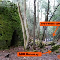
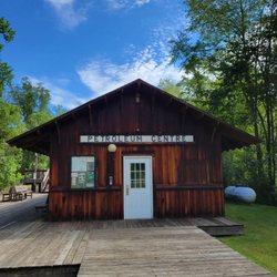
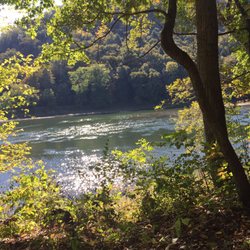
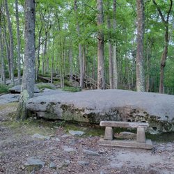
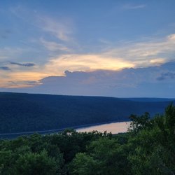
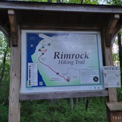
    Samuel Justus Trail Photos

    Recommended Reviews - Samuel Justus Trail

    Your trust is our priority, so businesses can't pay to alter or remove their reviews. Learn more about reviews.
    Yelp app icon
    Browse more easily on the app
    Review Feed Illustration
    Photo of Susan D.
    202
    828
    14

    15 years ago

    Helpful 5
    Thanks 0
    Love this 1
    Oh no 0

    10 years ago

    Helpful 0
    Thanks 0
    Love this 0
    Oh no 1

    Verify this business for free

    Get access to customer & competitor insights.

    Verify this business

    Sandy Creek Trail - Gorgeous rails to trails paved bike route. 24 mile round trip through some amazing scenery!!

    Sandy Creek Trail

    5.0(4 reviews)
    6.0 mi

    One of the prettiest bike rides I've ever taken! This amazing rails to trail fully paved bike path…read moreis 24 miles round trip through some truly spectacular scenery and woodlands. The largest of 7 wooden bridges along the path spans the Allegheny River and the smaller ones cross several creeks. What you don't see are any roads along this gorgeous wilderness path. There is a slight upward grade during much of the 12 miles from Fishermans Cove to the end of the line - the good news is it's nearly imperceptible until you turn around and head back. You feel like you're flying on your return trip which is really fun! This area is the definition of remote so go prepared with food, water & flat tire supplies. There's decent cell service, so bring your phone. There is also a fairly long tunnel mid-trail with reflectors down the center. A light would likely make you feel a tad more comfortable on a cloudy day. The reflectors work decently to direct you on a sunny day. This bike trail is located slightly over an hour north of Cranberry Township. Google map Seneca Hills Bible Camp which is where you turn off Old Route 8 off I-80. At the T heading to the Bible Camp you head right to Fisherman's Cove to the trailhead. If you're interested in more information and specific directions, here is a link: www.avta-trails.org ' sandy-creek-trail

    Wow. This is a spectacular trail!! Such a pleasant ride through the woods crossing the river and…read morecreek multiple times on a paved surface. I don't even know how they managed to get blacktop back into some of these remote areas but they did!! It's mostly shaded as well so even on hot days this would be a great choice when you just want to ride! We started at the western end of the trail called Fisherman's cove. A little tricky to find and accessible by a gravel road about 3 miles off old route 8. Parking here is limited and is roadside so I can imagine it getting pretty crowded on weekends. But it is so worth it. The eastern end is 12 miles out at Van. The ride back seemed a lot quicker since there appears to be a minor downhill heading back although it is an easy ride in both directions. The fact that it's quite remote means there are no road crossings so you can just ride completely carefree!! If you feel up to it you can extend the ride by joining up with other rails to trails and make a long day out of it!! We absolutely loved it and will no doubt be heading back there this fall to enjoy the ride and the scenery! Highly recommended!!

    Photos
    Sandy Creek Trail - The turn around point where the paved trail ends - or you could start here

    See all

    The turn around point where the paved trail ends - or you could start here

    Oil Creek State Park - Visitor's Center

    Oil Creek State Park

    5.0(5 reviews)
    6.5 mi

    This one is going to be a partial review. Why partial? Well, we barely scratched the surface of…read morewhat's at this beautiful state park and I want to come back to see more. On our way from Ohio to the other side of PA, we took a detour to get a look at where the modern petroleum industry got its start in this country. One big downside is that because this was ad-libbed, we entered the per se, "wrong side" of the park which doesn't have a much to see as the other side. Let me explain: As the below map shows, the park is laid out in a thin vertical line. Instead of arriving at the northern end where the Drake Well Musuem is, we showed up at the southern tip by the Egbert Farm Day Use Area. The big problem with that goes back to the adlibbing and not knowing that the bridge that leads over Oil Creek is long term closed to vehicles. It's possible to go around but it's a PIA and we didn't have enough time. www.dcnr.pa.gov/StateParks/FindAPark/OilCreekStatePark/pages/maps.aspx We saw Coal Oil Johnny's House, some of the Blood Farm Area and walked a bit of the snowy/muddy Gerard Trail before we ran out of daylight. uncoveringpa.com/things-to-do-oil-creek-state-park Jim at unoveringpa.com has a great list of stuff to do in the park and later this year I'm hoping to do a longer tour of the area and hit this place up for a few days along with Cherry Springs and Hyner Run. We didn't spend a long time here, but the appetite has been whet for more.

    This park is an intriguing blend of history and nature. This is the site of an oil boom town, and…read morethere are a number of historical indicators left memorializing it. An interpretive trail is located near the visitor's center that lets you stroll what used to be an old street in the town. None of the actual buildings remain, but the signage is great. There is a train visitor center where a train still runs through at times. There is also a nice playground and picnic tables available. The Blood Farm area is also beautiful - there's a nice large green space near the Oil Creek, with picnic tables, a playground, and shelterhouses. The Blood Farm Interpretive Trail provides an enjoyable short hike with some information about how the Blood Farm became a site where oil was discovered, and you can still find stopped off oil wells, old equipment and old farm buildings to view. Several waterfalls can be found here during certain times of year; unfortunately, the friendly staff told us that they weren't really running at the time of our visit. Very interesting park!

    Photos
    Oil Creek State Park - Train station

    Train station

    Oil Creek State Park - Oil Creek

    Oil Creek

    Oil Creek State Park - Playground

    See all

    Playground

    Asbury Woods - Holiday lights

    Asbury Woods

    5.0(10 reviews)
    49.6 mi

    Great place for nature walks of various lengths. There's a short boardwalk area on one side, a…read morelonger wooded walk, and a field area as well. As bury has a number of great programming for kids and families and a nice nature center too. A nice way to spend some time outdoors

    Asbury Woods is such a gem! This review is only for the hike, but I will definitely come back to…read morecheck out the nature center and everything else Asbury Woods has to offer. TL;DR - Free parking, Greenway Trail is the longest, is not very strenuous (just a few hills) is very shaded (unless you continue into the meadows, which is beautiful, you should go!), there are boardwalks on the trail which is pretty nice so your shoes don't get as muddy, you can customize trail distance if you don't want to do the whole Greenway (you can take a map at the entrance), Walnut Creek is beautiful and peaceful, and it's dog and family friendly. I saw lots of families on the trail with young kids. So for the details, my bf and I were looking for a place to hike and we tend to go for 2+ mi with some shade along the trail and some body of water, big or small. I browsed the web for info on Asbury Woods trails and saw that they were all short but the pictures seemed really nice and it was within 10 minutes of where I live so I figured I'd give it a shot. While driving here, I noticed there are 2 lots to park, one by the park, and the other is across the street by the main entrance by the nature center. So that's where I parked. We took one of their trail maps by the entrance and decided to go on the Greenway Trail, which we were pleasantly surprised to find is 2.2 mi and crosses Walnut Creek. Along the trail, we realize it is pretty shaded. Checks off all that I look for in a hike! This trail is beautiful!! Once you get to Walnut Creek, you'll realize it is such a gem! There weren't too many people on the trail for a Saturday around noon. The trail takes you across a bridge and into a meadow. Once we got to the meadow, I realize there are multiple places to enter the Woods, but I guess Google Maps took me to the main entrance. (The other way is the barn entrance.) Have fun!!

    Photos
    Asbury Woods - "Christmas is just around the corner"

    "Christmas is just around the corner"

    Asbury Woods - Holiday lights at asbury woods

    Holiday lights at asbury woods

    Asbury Woods - Holiday lights train room

    See all

    Holiday lights train room

    Allegheny River Trail - View of the Allegheny River right beside the bike trail

    Allegheny River Trail

    4.5(4 reviews)
    13.8 mi

    I love this hike, bike, tubing area. The best is tubing partway down the river and then hiking the…read moretrail back. Its beautiful and relaxing and well kept. If you bring your tube make sure youre prepared to take the air out to hike back.

    Absolutely gorgeous rails to trail. The Allegheny River runs literally beside you through the trees…read morewith amazing views on one side and mostly dense forest on the other side (plus some occasional residential). We started our bike ride in Emlenton off Interstate 80 on a perfect fall day and it's nearly flat and paved. I know! Its PA, how is nearly flat even possible? Of course, this means you pedal all the way - almost no coasting, but also no gasping for breath on an incline. Rails to trails inclines are always slight but sometimes miles long. None of that here. There are 2 fairly long, dark tunnels on this trail. I've discovered I'm not too fond of these! Hubby thinks they're like a Disney Ride, me not so much. You absolutely need lights on your bike because they are pitch black inside with reflectors down both sides and down the center. Just something to consider when planning your excursion. We did a nice 25 mile round trip from Emlenton to the Kennerdell Tunnel & back. Hubby did tunnel #2 & I photoed him! I still had to go back thru the 1st tunnel, which was quite enough for me. The beauty of this trail far surpasses my tunnel phobia! It's a clear 5 star!!!

    Photos
    Allegheny River Trail - Allegheny River views from the trail

    Allegheny River views from the trail

    Allegheny River Trail - June 2nd 2013 seen along the trail!

    June 2nd 2013 seen along the trail!

    Allegheny River Trail - A little rabbit surprised us June 2nd 2013!

    See all

    A little rabbit surprised us June 2nd 2013!

    Prince Gallitzin State Park - Water Tower on Headache Hill

    Prince Gallitzin State Park

    4.9(11 reviews)
    81.2 mi

    Growing up in an area, you never really understand what you have until you move away. You may have…read morethought that this was so boring to come here. You may think why are we going here. But when you move away, and come back for a visit, you want to revisit the area. First and foremost, nobody from this area ('locals' as the out-of-towners say) refers to this as Prince Gallitzin, Prince Gallitzin State Park, or PGSP. So stop it, it's not cute. We simply refer to it as Glendale. Yes, that is the name of the lake, but it is so much more simply to say Glendale than any form/combination you can come up with. The 'locals' here have it right, and you will not win an argument about it. What is appealing about this place is the many things you can do. Camping, swimming, boating, fishing, hiking, feed the deer, playgrounds, grilling, I could keep going. I spent many weekends here camping (to note: I am not a camper). With that, it was like I memorized a good portion of this park. When you camp, you hike, when you hike, you stumble upon a lot of the park. But, it is nearly impossible to see the whole park by foot, you will need a vehicle of some sort. The shoreline of the lake is 26 miles long. But there are so many more things to do in this area. Headache Hill is a favorite. Nothing more than a water tank tower on top of a highpoint. When open, you can climb the water tower and view the park in every direction. Uninterrupted views. The marina is a highlight. The "beach" is another highpoint. There can technically be a lot of beaches here. Be sure to check out the Killbuck Boat Ramp area. You can rent boats here to go out on the lake. You can also launch your boat here (one of very many places to do so). This is also where you can feed the deer. It is almost like clockwork. But be very aware of your surroundings. Feeding deer can draw other wildlife and a bear or two have been spotted here. If geocaching is your thing. There area a ton in the area. Hungry, check out Pirates Cove for sure, whether you want a meal or sweet treat. There are tons to do here. Not far from towns to grab items, it can serve as a nice little getaway. And please remember, it's Glendale.

    (To show how much Yelping means to me, our visit here was in January of '21 and I'm just getting…read morearound to thinking about this now.  Obviously I forget way more than I remember.) Who was Prince Gallitzin and why does he have a state park named after him? If you're so inclined feel free to skim this wiki on the Apostle of the Alleghenies. en.wikipedia.org/wiki/Demetrius_Augustine_Gallitzin PGSP is another creation of the late great Dr. Maurice Goddard who aspired to have a state park within 25 miles of every PA resident. He never reached that goal but he did add 45 parks during his decades long stint in state government including PGSP which was formally dedicated in 1965. So what's here? In the trademark of a lot of western PA state parks, not much and that's the beauty of it. I mean sure you can camp, glamp, hunt, fish, boat, hike, fart, etc. but there is also a loooooooooooot of quiet. elibrary.dcnr.pa.gov/GetDocument?docId=1737338&DocName=PRGA_ParkGuide.pdf What else do I remember: - We stayed in one of the ten cabins by the marina. Three of them allow dogs and obviously those book fairly far in advance especially on weekends. We stayed over a cold as hell weekend in January but I still needed to make the reservation two months out or else there would have been no availability. On the other side of Glendale Lake there are tons of spaces for camping year round but I don't camp so I can't testify about that. - If you need to pick up your cabin keys after the park office closes, head to the office and inside the foyer there are ten cubbies where they put the keys and a welcome/rules/map packet. Note that unless the process has changed, the email you get after you make a reservation does not mention this. Either you know, you guess or you'll have no clue. - IME, there is zero Internet capabilities in the cabins. Maybe that depends on the carrier but at the time, on T-Mobile, it was zip. - There are tons of houses selling firewood all around the area. I'm sure the park sells it somewhere but we bought a good bit from a stand a few miles away. - If you need provisions, there isn't much in the area. The town of Patton is ten minutes away and it has a Sheetz and one small store but past that you're probably going 30 minutes to Altoona for something more substantive. - The cabins are very, very nice. Full kitchens, good heating, nice enough bathrooms and it's usually a full bed with sets of bunks. - It snowed a few inches overnight and the park had their maintenance staff out salting and plowing the entrance roads very early in the morning which is good as most are narrow and winding. Overall the park is very nice. Lots of space/trails to spread out and explore on and the peaceful quiet is intoxicating. This one is definitely on our radar for a visit in the near future.

    Photos
    Prince Gallitzin State Park - Just walking right in the water.

    Just walking right in the water.

    Prince Gallitzin State Park - View from Headache Hill Water Tower

    View from Headache Hill Water Tower

    Prince Gallitzin State Park - View from Headache Hill Water Tower

    See all

    View from Headache Hill Water Tower

    Samuel Justus Trail - hiking - Updated June 2026

    Loading...
    Loading...
    Loading...