Scioto Greenway Trail Photos


You might also consider
More like Scioto Greenway Trail
Recommended Reviews - Scioto Greenway Trail
Start your review...

Reviews With Photos

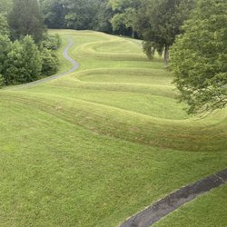
The oldest multiuse path in the city, the greenway starts in Grandview near 5th Avenue and follows route 33 to the post office and then splits section at Confluence Park, riding the river's east and west banks, before joining together at Main Street and eventually terminating at Frank Road in southern Columbus. On it's path are connecters intersecting the Olentangy trail and the Hilltop path. The main focus of this review will be on its new digs, just openned earlier this week, the western run downtown between Battelle and Bicentennial Parks. A few years in the making, the city has created a vibrant corridor here by shrinking the Scioto and placing a fresh green causeway for bikes and pedestrians in the created space. I was skeptical when I first caught wind of the plans; they were to destroy damns that were put in decades ago that had created a wider river, a more vast waterway that appealed to a civic grandeur; it looked like a major river in the time of the Avenue of Flags when it curled along Marconi, and the forgotten Riverside Amphitheater that floated in the bygone day. And what of the Scioto Mile, the still new pomenade now suddenly demoted from riverside walk to side of the riverside walk? Was this now a waste of resource, a mistake of impatience? Poor civic planning? In the end this was the correct call. The dams created a sedimentary pool that impeded the river's flow and reeked of sewage and sulfur. Now with sufficient flow, the river is a healthy bluish-green not the disease brown it used to be. Smaller now it is accessible for water sports, a pass-time pushed on grand-opening where several rentals paddled the waterway. With the installation of an underground sanitary system the smell is gone and the water safer. Moreover the trail bypasses the Mile ending the awkwardness of bike riding its narrow confines. The new trail is wide and lovely. Simple, they have developed a wide green space in the river valley that will in the coming years bloom to life with the maturity of the planted saplings and the growth of plants bordering the river. The turf laid down is already nice; you won't be able to tell it was recently a river bed from surveying the grass. The only other fabrications are some black street lamps, and a new river lookout that splits after Broad Street bridge. The entire thing is well done and adds something to the downtown district. As for the Mile the greenway takes nothing away from it leisurely stroll except the reek that once blemished it. The rest of the greenway has a utility that helps connect downtown with the south, west and northwest. As a pastime though, I find it less fun than other trails. The section from 5th to Confluence Park is noisy and busy due to the highway. The section from the post office to North Bank Park is better though still too rough and old. After Main Street the trail becomes rough and noisy again, like busy riverside with boating docks and urban overgrowth until it ends in the industrial badlands at Frank. It does cross by the Audubon Nature Center and through a 'haunted' stretch of Berliner Park. It's ok, but it doesn't pass as many interesting parks and sights as say the diverse delights of the Olentangy trail does. This is why I rate it only 4-stars.

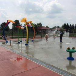
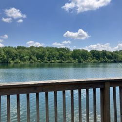
Beautiful trail/park that raps around a river. It looks large but I am not sure how long it is. There is a large interactive water fountain for kids which looks really fun. Wish there was one for adults :). There is a restaurant (Milestone 229) next to the water fountain to grab a bite and drink. Some parts of the trail lights up at night which adds to the beauty. They have swings on another section of the trail. COSI a science museum and research center is also located in the same vicinity. It is a really beautiful space. There are several parking spots on the surrounding streets as well as parking garages.

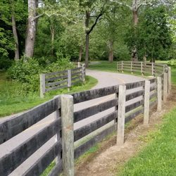
Wonderful path with a blend of nature and cityscape to keep one entertained. There are plenty of signs to help lead the novice in the direction they want to go. The trail is also large enough for groups to bike, walk, or run. I liked the blend of slight uphills and downhills without an overabundance of one over the other. I parked at the Grandview Pitstop to start my trek and it worked perfectly for a 13 mile ride. I am a biking novice so 13 miles is about a perfect ride for my first rode ride of the year. One could park at Confluence Park as well.

4 years ago
Loved strolling this area. Chose the street level path which had nice benches, foliage, excellent views of the river and downtown. There was also a lower path that followed the river. The joggers and bikers seemed to prefer that path. Not sure if the views are as good down there. read more


In honor of Earth Day, I've decided to review a new-to-me trail that I've recently fallen in love with. The Scioto Greenway Trail provides an excellent mix of mother nature and the beautiful cityscape that is Columbus. What do I love so much about it? Well, for starters it's easy for me to access and there's plenty of signage along the way so I don't get lost. Secondly, it spans several feet across and there's room for everyone, even during this time of social distancing. Whether you're biking, walking, going for a jog, or strolling along with some kiddos, there's space for everyone. Also, there's so much green!!! This isn't a city trail that happens to run through a park. This is a nature trail that just so happens to run alongside downtown with a great view of the skyline. Lastly, it's crazy clean, at least 95% of it is. There are a few homeless camps set up between the trail and the river and those areas can get a bit messy. There aren't really any cons except that in some areas of the trail, it gets a little decolate. Being a female that runs alone, I don't hit this up when the sun is setting or down. It's not well lit in all areas and I simply don't feel safe. That being said, any other time I feel completely safe by myself. I've recently added this to my list of run routes and I can't wait to experience it during different times of the year. I bet it's beautiful in fall. read more


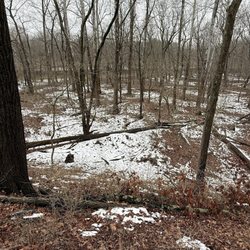
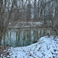
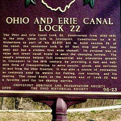
This whole area apparently used to be industrial, and a dam that was once downtown was demolished as it led to flooding and was replaced with a variety of parks and museums linked by this greenway trail. The river is muddy and unspectacular, while the frequent railway bridges remind one that there is still industry. The trail is long enough to spend hours on, and wide enough that I didn't have any big issues sharing the space with bikers and runners (I am neither). Bathrooms and water were available at the Scioto park towards the Southern end, but were a bit too infrequent on the other parks of the trail, as far as I could see. The trail is a good use of waterside space, and there is still room for expansion and improvement. read more


The oldest multiuse path in the city, the greenway starts in Grandview near 5th Avenue and follows route 33 to the post office and then splits section at Confluence Park, riding the river's east and west banks, before joining together at Main Street and eventually terminating at Frank Road in southern Columbus. On it's path are connecters intersecting the Olentangy trail and the Hilltop path. The main focus of this review will be on its new digs, just openned earlier this week, the western run downtown between Battelle and Bicentennial Parks. A few years in the making, the city has created a vibrant corridor here by shrinking the Scioto and placing a fresh green causeway for bikes and pedestrians in the created space. I was skeptical when I first caught wind of the plans; they were to destroy damns that were put in decades ago that had created a wider river, a more vast waterway that appealed to a civic grandeur; it looked like a major river in the time of the Avenue of Flags when it curled along Marconi, and the forgotten Riverside Amphitheater that floated in the bygone day. And what of the Scioto Mile, the still new pomenade now suddenly demoted from riverside walk to side of the riverside walk? Was this now a waste of resource, a mistake of impatience? Poor civic planning? In the end this was the correct call. The dams created a sedimentary pool that impeded the river's flow and reeked of sewage and sulfur. Now with sufficient flow, the river is a healthy bluish-green not the disease brown it used to be. Smaller now it is accessible for water sports, a pass-time pushed on grand-opening where several rentals paddled the waterway. With the installation of an underground sanitary system the smell is gone and the water safer. Moreover the trail bypasses the Mile ending the awkwardness of bike riding its narrow confines. The new trail is wide and lovely. Simple, they have developed a wide green space in the river valley that will in the coming years bloom to life with the maturity of the planted saplings and the growth of plants bordering the river. The turf laid down is already nice; you won't be able to tell it was recently a river bed from surveying the grass. The only other fabrications are some black street lamps, and a new river lookout that splits after Broad Street bridge. The entire thing is well done and adds something to the downtown district. As for the Mile the greenway takes nothing away from it leisurely stroll except the reek that once blemished it. The rest of the greenway has a utility that helps connect downtown with the south, west and northwest. As a pastime though, I find it less fun than other trails. The section from 5th to Confluence Park is noisy and busy due to the highway. The section from the post office to North Bank Park is better though still too rough and old. After Main Street the trail becomes rough and noisy again, like busy riverside with boating docks and urban overgrowth until it ends in the industrial badlands at Frank. It does cross by the Audubon Nature Center and through a 'haunted' stretch of Berliner Park. It's ok, but it doesn't pass as many interesting parks and sights as say the diverse delights of the Olentangy trail does. This is why I rate it only 4-stars. read more


Beautiful trail/park that raps around a river. It looks large but I am not sure how long it is. There is a large interactive water fountain for kids which looks really fun. Wish there was one for adults :). There is a restaurant (Milestone 229) next to the water fountain to grab a bite and drink. Some parts of the trail lights up at night which adds to the beauty. They have swings on another section of the trail. COSI a science museum and research center is also located in the same vicinity. It is a really beautiful space. There are several parking spots on the surrounding streets as well as parking garages. read more


Wonderful path with a blend of nature and cityscape to keep one entertained. There are plenty of signs to help lead the novice in the direction they want to go. The trail is also large enough for groups to bike, walk, or run. I liked the blend of slight uphills and downhills without an overabundance of one over the other. I parked at the Grandview Pitstop to start my trek and it worked perfectly for a 13 mile ride. I am a biking novice so 13 miles is about a perfect ride for my first rode ride of the year. One could park at Confluence Park as well. read more

7 years ago
11 years ago
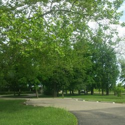
Beautiful green space. The city did a nice job with this. Statues, monuments and plenty of seating dot the area. Throw in a coffee vendor and this place would be perfect. read more


More info about Scioto Greenway Trail
233 City Center Dr
Groveport, OH 43125
Directions
(614) 645-7995
Call Now
Hours
Outdoor Amenities
Ask the Community - Scioto Greenway Trail


Scioto Greenway Trail - parks - Updated June 2026
Best of Groveport
People found Scioto Greenway Trail by searching for…
Water Parks in Groveport, Ohio
Scenic View in Groveport, Ohio
Campgrounds in Groveport, Ohio
Beautiful Views in Groveport, Ohio
Off Road Trails in Groveport, Ohio
Things to Do Alone in Groveport, Ohio
Skyline View in Groveport, Ohio
Fun Things to Do With Kids in Groveport, Ohio
Running Trails in Groveport, Ohio
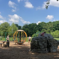
Playgrounds in Groveport, Ohio
River Swimming in Groveport, Ohio
Places to Take Pictures in Groveport, Ohio
Hiking Trails With Waterfalls in Groveport, Ohio
Picnic Areas in Groveport, Ohio
Flower Fields in Groveport, Ohio
Tourist Attractions in Groveport, Ohio
Scenic Overlook in Groveport, Ohio
Walking Trails in Groveport, Ohio
Trending Searches in Groveport, OH
Baseball Fields near Scioto Greenway Trail
Beaches near Scioto Greenway Trail
Black Owned Nail Salons near Scioto Greenway Trail
Boardwalk near Scioto Greenway Trail
Boat Rental near Scioto Greenway Trail
Cliff Jumping near Scioto Greenway Trail
Day Trips near Scioto Greenway Trail
Dog Friendly Beaches near Scioto Greenway Trail
Fishing Spots near Scioto Greenway Trail
Free Kids Activities near Scioto Greenway Trail
Free Picnic Areas near Scioto Greenway Trail
Kayak Rental near Scioto Greenway Trail
Kids Activities Outdoor near Scioto Greenway Trail
Lakes near Scioto Greenway Trail
Outdoor Basketball Courts near Scioto Greenway Trail
Parks With Pull Up Bars near Scioto Greenway Trail
Pick Your Own Farms near Scioto Greenway Trail
River Swimming near Scioto Greenway Trail
Sand Volleyball Courts near Scioto Greenway Trail
Soccer Store near Scioto Greenway Trail
Splash Pad near Scioto Greenway Trail
Strawberry Picking near Scioto Greenway Trail
Swimming Holes near Scioto Greenway Trail
Swimming Lakes near Scioto Greenway Trail
Swimming Pools near Scioto Greenway Trail
Watch Sunset near Scioto Greenway Trail
Browse Articles
Browse Nearby
BEST of Groveport, Ohio Restaurants near Scioto Greenway Trail
BEST of Groveport, Ohio Things to Do near Scioto Greenway Trail
BEST of Groveport, Ohio Coffee near Scioto Greenway Trail
BEST of Groveport, Ohio Playgrounds near Scioto Greenway Trail
BEST of Groveport, Ohio Hiking near Scioto Greenway Trail
BEST of Groveport, Ohio Breakfast near Scioto Greenway Trail
BEST of Groveport, Ohio Campgrounds near Scioto Greenway Trail
Browse Brands
Related Searches in Groveport, OH
Best Off Leash Dog Parks in Groveport, Ohio
Best Parks for Parties and Events in Groveport, Ohio
Best Water Parks for Kids in Groveport, Ohio
Check Out Great Playgrounds in Groveport, Ohio
Discover Baseball Fields Around Groveport, Ohio
Discover Free Parking Options in Groveport, Ohio
Discover Lakes & Ponds to Explore in Groveport, Ohio
Discover Popular Photo Spots in Groveport, Ohio
Discover Soccer Fields in Groveport, Ohio Near You
Discover Top Nature Parks to Visit in Groveport, Ohio
Discover the Best Beaches in Groveport, Ohio
Enjoy the Best Walking Trails in Groveport, Ohio
Experience Stunning Sunset Views in Groveport, Ohio
Explore Family-Friendly Zoos and Wildlife in Groveport, Ohio
Explore Free Picnic Areas Around Groveport, Ohio
Explore Fun Activities to Do in Groveport, Ohio
Explore Parks With Pull Up Bars in Groveport, Ohio
Explore Pickleball Courts in Groveport, Ohio
Explore Popular Campgrounds Near Groveport, Ohio
Explore Popular Picnic Areas Around Groveport, Ohio
Explore Popular RV Parks Around Groveport, Ohio
Explore Popular Recreation Centers Around Groveport, Ohio
Explore Scenic Lakes to Visit in Groveport, Ohio
Explore Secret Spots Worth Visiting in Groveport, Ohio
Explore Top Dog Parks in Groveport, Ohio Near You
Explore Top Gyms in Groveport, Ohio Now
Explore Top Water Parks in Groveport, Ohio Today
Explore the Best Swimming Holes Around Groveport, Ohio
Find Top Dog Friendly Parks to Visit in Groveport, Ohio
Find Top Skate Parks in Groveport, Ohio for All Skill Levels
Find Top-Rated Waterfalls in Groveport, Ohio Now
Find a Park With BBQ Pits in Groveport, Ohio
Find the Best Parks for Picnics in Groveport, Ohio
Find the Best Swimming Pools in Groveport, Ohio Today
Fun Things for Kids in Groveport, Ohio
Great Places to Swim in Groveport, Ohio
Have Fun at a Splash Pad in Groveport, Ohio
Locate Tennis Courts Around Groveport, Ohio
Parks With Basketball Courts for Games in Groveport, Ohio
Picnic Areas With BBQ Pits Available in Groveport, Ohio
Popular Fishing Spots to Explore in Groveport, Ohio
Popular Outdoor Activities to Try in Groveport, Ohio
Popular Places to Take Pictures in Groveport, Ohio
Top Hiking Trails to Explore in Groveport, Ohio
Top Running Trails to Explore in Groveport, Ohio
Top Swimming Lakes to Enjoy in Groveport, Ohio
Top-Rated Basketball Courts to Play at in Groveport, Ohio
Visit Popular Museums in Groveport, Ohio Now
Visit Top Toddler Playgrounds in Groveport, Ohio for Playtime
People who viewed Scioto Greenway Trail also viewed
Battelle Riverfront Park
8 reviews
Downtown
Boch Hollow State Nature Preserve
5 reviews
Blackburn Park
2 reviews
Olde Towne East
Sensenbrenner Park
2 reviews
Downtown
Olentangy Park
2 reviews
Heritage Rail Trail
14 reviews
First Responders Park
6 reviews
Three Creeks Dog Park
8 reviews
Southeast
Veterans Memorial Park
1 review
Cantwell Cliffs
3 reviews