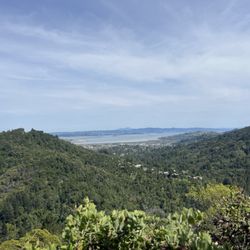
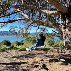
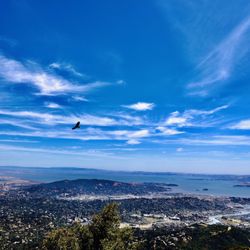
Tam Hiking Tours Hiking Photos


You might also consider
More like Tam Hiking Tours
Recommended Reviews - Tam Hiking Tours
Start your review...

Reviews With Photos

I recently spent a 4-day weekend in the Bay Area filled with lots of fun outdoor activities but I have to say that hiking with Debra at Tam Hiking Tours was my absolute favorite part of the trip! She is such a delight! So full of life and positive energy! We learned so many fun facts and history along the way and the hike was so beautiful I just about cried. It was refreshing and therapeutic. I can not wait to go back for more adventures with her!


Deb, aka my spirit mom, leads such an amazing tour! Being a transplant from Tennessee to SF I confided in Deb how much I missed being in nature the first time I met her. Right away she said "Don't make any plans Tuesday we're going on the mountain!" I fell in love with Mount Tam immediately thanks to its gorgeous landscape and Deb's amazing guiding . It's exactly what I need when I'm feeling claustrophobic in the city. Honestly I could not thank Deb enough for leading such an incredible tour. I'm fairly positive my trips into nature with her have kept me sane while living amongst the insane San Francisco.

10 years ago


10 years ago
I recently spent a 4-day weekend in the Bay Area filled with lots of fun outdoor activities but I have to say that hiking with Debra at Tam Hiking Tours was my absolute favorite part of the trip! She is such a delight! So full of life and positive energy! We learned so many fun facts and history along the way and the hike was so beautiful I just about cried. It was refreshing and therapeutic. I can not wait to go back for more adventures with her! read more

11 years ago
A truly remarkable experience! Mt. Tam is always a great hike, but with Debra you will really come away with a deeper understanding of the area. I can't recommend Deb enough she really does an awesome job. Thanks so much Deb for the amazing adventures. I look forward to the next one! read more


Business owner information
Debra S.
Thanks for sharing your photos David. We were lucky to meet Mill…
11 years ago
11 years ago
Deb, aka my spirit mom, leads such an amazing tour! Being a transplant from Tennessee to SF I confided in Deb how much I missed being in nature the first time I met her. Right away she said "Don't make any plans Tuesday we're going on the mountain!" I fell in love with Mount Tam immediately thanks to its gorgeous landscape and Deb's amazing guiding . It's exactly what I need when I'm feeling claustrophobic in the city. Honestly I could not thank Deb enough for leading such an incredible tour. I'm fairly positive my trips into nature with her have kept me sane while living amongst the insane San Francisco. read more

11 years ago
6 years ago
12 years ago
Business owner information
Debra S.
Working with schools is a great pleasure. Hope to see you next year!…
7 years ago
11 years ago
Deb was amazing. She knows so much! A true keeper of history and lover of the earth. I would love to hike with her again. Went with a mommy's hiking group, I was skeptical about paying for a hike, but wow was it worth it. I would love to do it again, but by myself so we could go faster than a group, and so I can have her and her stories to myself! read more

11 years ago
12 years ago
11 years ago
More info about Tam Hiking Tours
Mill Valley, CA 94941
Directions
(415) 888-2474
Call Now
Visit Website
http://www.tamhikingtours.com
Hours
Outdoor Amenities
From the Business
Ask the Community - Tam Hiking Tours
Review Highlights - Tam Hiking Tours
You might also consider


Why does Yelp recommend reviews?
1 review that is not currently recommended
The reviews below are not factored into the business's overall star rating.
11 years ago
Tam Hiking Tours - hiking - Updated June 2026
Best of Mill Valley
People found Tam Hiking Tours by searching for…
Hiking Club in Mill Valley, CA
Hiking Trails With Waterfalls in Mill Valley, CA
Scenic View in Mill Valley, CA
Redwood Trees in Mill Valley, CA
Playgrounds in Mill Valley, CA
Parks for Kids in Mill Valley, CA
Dog Friendly Hiking Trails in Mill Valley, CA
Redwood Forest in Mill Valley, CA
Walking Trails in Mill Valley, CA
Waterfalls and Swimming Holes in Mill Valley, CA
Sunrise View in Mill Valley, CA
Fun Things to Do at Night in Mill Valley, CA
Hiking Groups in Mill Valley, CA
Secret Spots in Mill Valley, CA
Shaded Hike in Mill Valley, CA
Mountain Huts in Mill Valley, CA
Things to Do With Kids in Mill Valley, CA
Running Trails in Mill Valley, CA
Things to Do With Teenagers in Mill Valley, CA
Trending Searches in Mill Valley, CA
Boat Rental near Tam Hiking Tours
Bounce House Rentals near Tam Hiking Tours
Cliff Jumping near Tam Hiking Tours
Dog Friendly Things To Do near Tam Hiking Tours
Flower Fields near Tam Hiking Tours
Flower Shop near Tam Hiking Tours
Golf Cart Rentals near Tam Hiking Tours
Jet Ski Rental near Tam Hiking Tours
Movie Theatre near Tam Hiking Tours
Nurseries & Gardening near Tam Hiking Tours
Outdoor Activities near Tam Hiking Tours
Pedicure near Tam Hiking Tours
Pick Your Own Farms near Tam Hiking Tours
Picnic Areas near Tam Hiking Tours
Rock Quarry near Tam Hiking Tours
Running Trails near Tam Hiking Tours
Scenic Drive near Tam Hiking Tours
Secluded Spots near Tam Hiking Tours
Splash Pad near Tam Hiking Tours
Strawberry Picking near Tam Hiking Tours
Summer Camps near Tam Hiking Tours
Sunrise View near Tam Hiking Tours
Swimming Holes near Tam Hiking Tours
Swimming Pools near Tam Hiking Tours
Watch Sunset near Tam Hiking Tours
Browse Articles
Browse Nearby
BEST of Mill Valley, California Coffee near Tam Hiking Tours
BEST of Mill Valley, California Restaurants near Tam Hiking Tours
BEST of Mill Valley, California Things to Do near Tam Hiking Tours
BEST of Mill Valley, California Walking Trails near Tam Hiking Tours
BEST of Mill Valley, California Breakfast near Tam Hiking Tours
BEST of Mill Valley, California Parks near Tam Hiking Tours
BEST of Mill Valley, California Campgrounds near Tam Hiking Tours
BEST of Mill Valley, California Sightseeing near Tam Hiking Tours
BEST of Mill Valley, California Visitor Centers near Tam Hiking Tours
Browse Brands
Related Searches in Mill Valley, CA
Affordable Kayak Rental Services in Mill Valley, California
Best Fishing Locations and Guides in Mill Valley, California
Best Nature Trails for Hiking in Mill Valley, California
Best Places for Horseback Riding in Mill Valley, California
Check Out Off Road Trails in Mill Valley, California
Discover Dog Friendly Trails to Explore in Mill Valley, California
Discover Kid Friendly Hiking Trails in Mill Valley, California
Discover Scenic Hiking Trails in Mill Valley, California
Discover Scenic Mountain Bike Trails Near Mill Valley, California
Discover Scenic Waterfall Spots in Mill Valley, California
Discover Top Nature Parks to Visit in Mill Valley, California
Discover Walking Parks in Mill Valley, California Near You
Discover a Hiking Trail in Mill Valley, California
Discover the Best Night Hike Trails in Mill Valley, California
Discover the Best Running Track in Mill Valley, California
Dog-Friendly Hikes With Dogs in Mill Valley, California
Enjoy Camping Adventures Around Mill Valley, California
Enjoy Kayaking Adventures in Mill Valley, California
Enjoy Tent Camping Spots Around Mill Valley, California
Enjoy a Beautiful Waterfall Hike in Mill Valley, California
Enjoy the Best Picnic Spots and Ideas in Mill Valley, California
Enjoy the Best Walking Path in Mill Valley, California
Enjoy the Best Walking Trails in Mill Valley, California
Exciting Cliff Jumping Spots in Mill Valley, California
Explore Beautiful Parks and Green Spaces in Mill Valley, California
Explore Easy Hikes Perfect for All in Mill Valley, California
Explore Fun Activities to Do in Mill Valley, California
Explore Popular Campgrounds Near Mill Valley, California
Explore the Best Beach Spots in Mill Valley, California
Explore the Best Swimming Holes Around Mill Valley, California
Explore the Best Trail Options in Mill Valley, California
Family Friendly Hiking With Kids in Mill Valley, California
Find Beautiful Views in Mill Valley, California
Find the Best Parks for Picnics in Mill Valley, California
Find the Best Scenic View Locations in Mill Valley, California
Great Places to Walk in Mill Valley, California
Hike the Popular Waterfall Trail in Mill Valley, California
Hiking Trails With Waterfalls in Mill Valley, California
Off Leash Dog Hiking Trails in Mill Valley, California
Plan a Scenic Drive Route Near Mill Valley, California
Popular Outdoor Activities to Try in Mill Valley, California
Popular Picnic Spots to Visit in Mill Valley, California
Safe River Swimming Areas in Mill Valley, California
Safe and Fun Parks for Kids in Mill Valley, California
Top Climbing Spots and Gyms in Mill Valley, California
Top Running Trails to Explore in Mill Valley, California
Top Swimming Lakes to Enjoy in Mill Valley, California
Top Swimming Spots and Pools in Mill Valley, California
Walk Dog Friendly Hiking Trails in Mill Valley, California
Walk the Best Paved Walking Trails in Mill Valley, California
People who viewed Tam Hiking Tours also viewed
Terra Linda Sleepy Hollow Ridge
14 reviews
Terra Linda-Sleepy Hollow Divide Northern Preserve
10 reviews
Natalie Coffin Greene Park
12 reviews
Old St. Hilary's Open Space Nature Preserve
12 reviews
Deer Park Trailhead
3 reviews
Ridgewood Trail
1 review
King Mountain
8 reviews
Point Reyes Adventure Co
16 reviews
Audubon Canyon Ranch
6 reviews
Miwok Park
13 reviews