West Ridge Trail Photos


You might also consider
More like West Ridge Trail
Recommended Reviews - West Ridge Trail
Start your review...

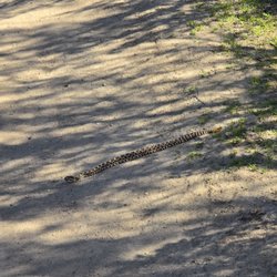
Reviews With Photos

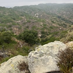
This is part of Aliso and Wood Canyons Wilderness Park but I still feel that it should be added because it can stand on it's own as a single trail. I wanted to find a way to get to Top of the World without wasting time by driving to Laguna Beach and I found this trail which is a back way from Aliso Viejo. It's very convenient if you live in Aliso Viejo. I park in a residential neighborhood and then get on the trail. It's easy to follow and thankfully there are signs pointing you in the right direction. It's a challenging trail for me because it has a few steep hills but the views are stunning.

5 months ago
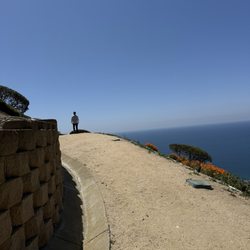
Nice trail mid week, but be prepared for a very busy trail on the weekends. Lots of bikes on the weekends. Much more enjoyable & quiet during the week. No matter when you go, the trail is wide and maintained. About 4.5 miles if you go out and back from the neighborhood to the end at Top of the World. Great views of the ocean and OC. The wild flowers were in bloom when we hiked. Good workout! read more


5 months ago
5 years ago
Being the first trail listed on an "OC hikes with amazing views" article, naturally I had to see this so called amazing for myself! This trail is part of Aliso and Wood Canyons Wilderness Park & tucked away in a little residential area with street parking. There are many signs throughout the trail to lead you, so that definitely makes solo hikers like myself feel more comfortable. This trail is about 4.5 miles long & a breeze to get through, with just a few mini inclines every now and then. It does get slightly crowded but with how extra wide the trail is, don't worry about any fellow hikers being in a close proximity to you. Tons of bikers & families take this route, as well. I really like this trail because the views are so breath taking (literally haha) that I just wanted to stop & take it all in every 10 minutes. Once you get to the end of the trail, which is Top of the World in Laguna Beach, that's when you'll really be in awe of nature's beauty - sea on one side & hills on the other. This hike will get your heart pumping but it's not strenuous enough to say it's the most difficult, very doable for anyone. read more


This is part of Aliso and Wood Canyons Wilderness Park but I still feel that it should be added because it can stand on it's own as a single trail. I wanted to find a way to get to Top of the World without wasting time by driving to Laguna Beach and I found this trail which is a back way from Aliso Viejo. It's very convenient if you live in Aliso Viejo. I park in a residential neighborhood and then get on the trail. It's easy to follow and thankfully there are signs pointing you in the right direction. It's a challenging trail for me because it has a few steep hills but the views are stunning. read more

5 years ago
Great moderate hike , little tricky to get to but there are maps once you get there that leads to whatever trail you would like to take. Went straight on wood canyon trail this time . It has been raining lately so there were several natural brooks. This was a very nice trail to get exercise as well as enjoy nature. read more


More info about West Ridge Trail
94 Hollyleaf
Aliso Viejo, CA 92656
Directions
Hours
Outdoor Amenities
You might also consider


West Ridge Trail - hiking - Updated July 2026
Best of Aliso Viejo
People found West Ridge Trail by searching for…
Hiking Trails in Aliso Viejo, California
Beaches in Aliso Viejo, California
Walking Trails in Aliso Viejo, California
Easy Hikes in Aliso Viejo, California
Beautiful Views in Aliso Viejo, California
Parks in Aliso Viejo, California
Free Things to Do in Aliso Viejo, California
Trails in Aliso Viejo, California
Scenic View in Aliso Viejo, California
Running Trails in Aliso Viejo, California
Kid Friendly Hiking Trails in Aliso Viejo, California
Stroller Friendly Hikes in Aliso Viejo, California
Shaded Hike in Aliso Viejo, California
Places to Walk at Night in Aliso Viejo, California
Things to Do at Night in Aliso Viejo, California
Views in Aliso Viejo, California
Canyoneering in Aliso Viejo, California
Forest in Aliso Viejo, California
Night Hiking in Aliso Viejo, California
Nature Parks in Aliso Viejo, California
Off Road Trails in Aliso Viejo, California
Places to Walk in Aliso Viejo, California
Trending Searches in Aliso Viejo, CA
4th Of July Fireworks in Aliso Viejo, CA
Black Owned Nail Salons in Aliso Viejo, CA
Boat Rental in Aliso Viejo, CA
Cliff Jumping in Aliso Viejo, CA
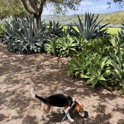
Dog Friendly Trails in Aliso Viejo, CA
Jet Ski Rental in Aliso Viejo, CA
Kayak Rental in Aliso Viejo, CA
Lakes & Ponds in Aliso Viejo, CA
Outdoor Activities in Aliso Viejo, CA
Places To Walk Around in Aliso Viejo, CA
Public Pools in Aliso Viejo, CA
Public Shower in Aliso Viejo, CA
Rock Quarry in Aliso Viejo, CA
Running Trails in Aliso Viejo, CA
Scenic Night View in Aliso Viejo, CA
Scenic Overlook in Aliso Viejo, CA
Secluded Spots in Aliso Viejo, CA
Soccer Store in Aliso Viejo, CA
Strawberry Picking in Aliso Viejo, CA
Sunrise View in Aliso Viejo, CA
Swimming Holes in Aliso Viejo, CA
Swimming Lakes in Aliso Viejo, CA
Swimming Pools in Aliso Viejo, CA
Watch Sunset in Aliso Viejo, CA
Browse Articles
Browse Nearby
BEST of Aliso Viejo, California Coffee near West Ridge Trail
BEST of Aliso Viejo, California Restaurants near West Ridge Trail
BEST of Aliso Viejo, California Things to Do near West Ridge Trail
BEST of Aliso Viejo, California Breakfast near West Ridge Trail
BEST of Aliso Viejo, California Walking Trails near West Ridge Trail
BEST of Aliso Viejo, California Parks near West Ridge Trail
BEST of Aliso Viejo, California Hot Springs near West Ridge Trail
BEST of Aliso Viejo, California Campgrounds near West Ridge Trail
Browse Brands
Related Searches in Aliso Viejo, CA
Affordable Kayak Rental Services in Aliso Viejo, California
Best Fishing Locations and Guides in Aliso Viejo, California
Best Nature Trails for Hiking in Aliso Viejo, California
Best Places for Horseback Riding in Aliso Viejo, California
Check Out Off Road Trails in Aliso Viejo, California
Discover Dog Friendly Trails to Explore in Aliso Viejo, California
Discover Kid Friendly Hiking Trails in Aliso Viejo, California
Discover Scenic Hiking Trails in Aliso Viejo, California
Discover Scenic Mountain Bike Trails Near Aliso Viejo, California
Discover Scenic Waterfall Spots in Aliso Viejo, California
Discover Top Nature Parks to Visit in Aliso Viejo, California
Discover Walking Parks in Aliso Viejo, California Near You
Discover a Hiking Trail in Aliso Viejo, California
Discover the Best Night Hike Trails in Aliso Viejo, California
Dog-Friendly Hikes With Dogs in Aliso Viejo, California
Enjoy Camping Adventures Around Aliso Viejo, California
Enjoy Exciting Mountain Biking Adventures in Aliso Viejo, California
Enjoy Kayaking Adventures in Aliso Viejo, California
Enjoy Tent Camping Spots Around Aliso Viejo, California
Enjoy a Beautiful Waterfall Hike in Aliso Viejo, California
Enjoy a Peaceful Nature Walk in Aliso Viejo, California
Enjoy the Best Picnic Spots and Ideas in Aliso Viejo, California
Enjoy the Best Walking Path in Aliso Viejo, California
Enjoy the Best Walking Trails in Aliso Viejo, California
Explore Beautiful Parks and Green Spaces in Aliso Viejo, California
Explore Easy Hikes Perfect for All in Aliso Viejo, California
Explore Popular Campgrounds Near Aliso Viejo, California
Explore the Best Beach Spots in Aliso Viejo, California
Explore the Best Swimming Holes Around Aliso Viejo, California
Explore the Best Trail Options in Aliso Viejo, California
Family Friendly Hiking With Kids in Aliso Viejo, California
Find Beautiful Views in Aliso Viejo, California
Find the Best Parks for Picnics in Aliso Viejo, California
Find the Best Scenic View Locations in Aliso Viejo, California
Great Places to Walk in Aliso Viejo, California
Hike the Popular Waterfall Trail in Aliso Viejo, California
Hiking Trails With Waterfalls in Aliso Viejo, California
Off Leash Dog Hiking Trails in Aliso Viejo, California
Plan a Scenic Drive Route Near Aliso Viejo, California
Popular Outdoor Activities to Try in Aliso Viejo, California
Popular Picnic Spots to Visit in Aliso Viejo, California
Safe River Swimming Areas in Aliso Viejo, California
Safe and Fun Parks for Kids in Aliso Viejo, California
Top Climbing Spots and Gyms in Aliso Viejo, California
Top Paddleboarding Activities in Aliso Viejo, California
Top Running Trails to Explore in Aliso Viejo, California
Top Swimming Lakes to Enjoy in Aliso Viejo, California
Top Swimming Spots and Pools in Aliso Viejo, California
Walk Dog Friendly Hiking Trails in Aliso Viejo, California
Walk the Best Paved Walking Trails in Aliso Viejo, California
People who viewed West Ridge Trail also viewed
Aliso Summit Trail
65 reviews
Holy Jim Falls Trail
217 reviews
Valido Trail
84 reviews
Badlands Park
46 reviews
Thomas F. Riley Wilderness Park
39 reviews
Sea Summit At Marblehead Trail
31 reviews
Bell View Trail
3 reviews
James Dilley Greenbelt Preserve
3 reviews
Wandering Trail
1 review
Buck Gully Reserve
45 reviews