Cancel

    Open app

    Search

    White Lake Natural Resource Area

    5.0 (1 review)

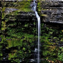
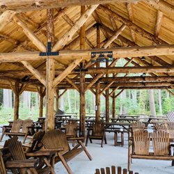
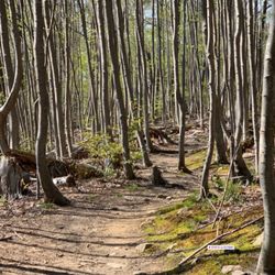
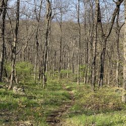
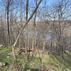
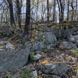
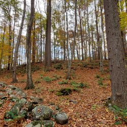
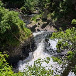
    White Lake Natural Resource Area Photos

    You might also consider

    More like White Lake Natural Resource Area

    Recommended Reviews - White Lake Natural Resource Area

    Your trust is our priority, so businesses can't pay to alter or remove their reviews. Learn more about reviews.
    Yelp app icon
    Browse more easily on the app
    Review Feed Illustration
    Photo of Spike R.
    39
    239
    1190

    3 years ago

    Helpful 1
    Thanks 0
    Love this 0
    Oh no 0

    You might also consider

    Verify this business for free

    People searched for Boating 314 times last month within 15 miles of this business.

    Verify this business

    Delaware Water Gap National Recreation Area - Beautiful!

    Delaware Water Gap National Recreation Area

    4.6(38 reviews)
    7.4 mi

    Was looking for someplace to go in the fall and the finger lakes and Lake George were too far away,…read morebut gap was only an hour away! Who would think there a place is beautiful so close to home living in Central New Jersey! What makes a Delaware water gap so special in the fall is that there are some large hills here making the foliage extra special! The beauty of this place is incredible, you might feel like you're out west somewhere in the middle of Montana! There's an incredible hiking or biking trail that runs right alongside the Delaware water gap. There's also many absolutely amazing waterfalls in the area! We stayed two nights over a weekend and I felt like I had a great little vacation! Highly recommended if you're looking for a nearby gorgeous spot for nature anytime of the year! If you're like me and live in Central New Jersey, you don't have to go to upstate New York to get that kind of beauty. You can get it right here in Delaware water gap! They have a welcome center with people there that will help you with all your questions and needs for what you're looking for exclamation

    We visited the Delaware Water Gap today, and it was a wonderful experience. This time of year is…read moreperfect for exploring the area. If you haven't been here before, I highly recommend it. There are numerous hiking trails, camping spots, and opportunities for photography and kayaking. Plan to spend a few hours to fully enjoy everything this beautiful area has to offer.

    Photos
    Delaware Water Gap National Recreation Area - We took a ride to the Delaware water gap today. Gotta love this time of the year

    We took a ride to the Delaware water gap today. Gotta love this time of the year

    Delaware Water Gap National Recreation Area
    Delaware Water Gap National Recreation Area

    See all

    Bushkill Falls - Right after paying, before entering the trail, they have this little area with different displays...they change it around from time to time

    Bushkill Falls

    4.0(355 reviews)
    9.5 mi

    One of a very good falls near NJ .. it is about 1.30 hrs or 2 hours drive from central Jersey but…read moreit is worth the drive . We have been to this place few years back but now it became toooo crowded and sometimes it takes a lot of time to go through the crowd . Well maintained pathways . There are 3-4 different loops and based on the time you have you can choose one path .. yellow loops are average difficulty .. it does have some path which is a little steep steps, but not difficult for middle age people.. might be a little stressful for elderly people with knee pain issues.. there is also a red loop which is a lot more of Walk and takes more time.. there are maps showing each path and approximate distance.. parking is a bit crazy, especially near the entrance.. parking is free.. tickets are about $21 which isn't too bad . Liked it overall .

    I saw pictures of Bushkill Falls and thought it would be a must-see while visiting the area. The…read moreentrance is easy to find with clear signage, and staff were very friendly. Tickets are $22 per person, which feels a bit pricey, and bags are checked before you go in. The grounds have shops, picnic areas for lunch, and even a mining gemstone area for kids. Bathrooms are available, though they could have been cleaner. The experience itself isn't a typical hiking trail -- instead, it's a series of wooden walkways and bridges that guide you to each waterfall. The views are beautiful, but be prepared for crowds. On weekends especially, it can feel shoulder-to-shoulder most of the time. I'd only recommend bringing very well-behaved or small dogs since there isn't much room to move around people. We ended up leaving earlier than planned because of how packed it was, but I could see Bushkill Falls being a nice day trip, especially during the week when it's less busy. The waterfalls are definitely worth seeing, just go with the right expectations!

    Photos
    Bushkill Falls - Big pavilion & central meeting spot if separated

    Big pavilion & central meeting spot if separated

    Bushkill Falls - Local species exhibit

    Local species exhibit

    Bushkill Falls - Local species exhibit

    See all

    Local species exhibit

    Raymondskill Falls

    Raymondskill Falls

    4.7(33 reviews)
    20.2 mi

    I have been coming here for years and it has always been so beautiful. I love morning hikes…read more Seeing the water falls and hiking through the trails is so picturesque. It's a great cardio workout. We climb up trail stairs and down. We go up some hills and down. It really depends on the direction you decide to take. Fall is my favorite time of year to come here when the weather is a bit cooler and there is not as much people around. The trails in this this park is very clearly marked and you can see trails that were created by the parks department plus some that were created by people who wanted to adventure off the regular trails. There are some very very small caves if you look around hard enough. I see them take a quick peek and I am on my way. I am not that adventurous, lol. This is definitely a fantastic place to visit if you are in the area. Just a couple of things to remember. Bug spray is your friend. Spray yourself, ticks are not fun and also be careful when running your hands on the wooden handrails because there may be splinters. I now take tweezers with me just in case splinters or ticks but this park is still a fantastic place to visit.

    Really beautiful site, but it was hard to find. The address in the tour book took us to a closed,…read moreprivate road, and it's a windy two lane road with no shoulder, so it was also hard to find a place to turn around. There is a bit of a pull off area, and there is a restroom, but when I went off season (warm but not declared in season) it was locked. So mileage may vary on its usefulness. Luckily, if your eagle eyes spot the pullover parking lot, the falls are a pretty short walk. I recommend taking the path to the right to the top of the falls so you can then move down the steep incline instead of going up. The view from the bottom is very pretty. It's a good view and only needs like 20 minutes tops of your time. It was quite doable for my senior mother, but some parts were very slow moving. She enjoyed it, so it does still work for beginners as long as it's not been raining. Would recommend stopping by if you like seeing waterfalls. It's the tallest in the state and very scenic.

    Photos
    Raymondskill Falls
    Raymondskill Falls
    Raymondskill Falls - View from platform of lowest falls.

    See all

    View from platform of lowest falls.

    Mount Tammany - Scumbags leaving their trash on the trail.

    Mount Tammany

    4.9(8 reviews)
    7.3 mi

    This place is absolutely beautiful, highly recommend. It's super popular, so the parking lot gets…read morepretty full. Come early! It's 3.5 miles, 1,250 feet elevation. You get a pretty good cardio workout as you traverse across the rock scrambles. It's a somewhat strenuous hike. For an easier time, go up the Red Dot trail and come down the Blue Dot trail. It's a loop! If you're looking for a less strenuous hike, you can go up and down the Blue Dot trail, but you'll miss a good view on the Red Dot trail. The Red Dot trail has an amazing view of the Delaware Water Gap and Mt Minsi. As you go further up, you'll reach the high point. Going down the Blue Dot trail, you'll eventually come across beautiful waterfalls and hike right by the river. Absolutely gorgeous! Don't forget to bring plenty of water!

    This is one of the better hikes you will enjoy, never a dull moment, you get lots of rock…read morescrambling on top of a view. I thought this trail would be overridden by tourists and post Covid new hikers but I was shocked it wasn't crowded - went on black friday, maybe everyone was shopping and it was a little chilly. After thorough research, best route up is by taking the red trail and taking the blue trail back. The red trail up to the top is all rock scrambling, constant climbing up rocks till you get to the top. The blue trail back is not as much scrambling and a gradual decline down rather than a straight up climb. I can't imagine taking the red trail down, it would take longer and is definitely harder. There are multiple parking lots so beware of where you park though the lots are close by walking distance. McDonald's is 7 minutes away without traffic so that can be a great incentive to come, grab grub right after. When I finished hike around 1, parking lot was quite full.

    Photos
    Mount Tammany
    Mount Tammany
    Mount Tammany

    See all

    Worthington State Forest

    Worthington State Forest

    4.2(50 reviews)
    9.9 mi

    Stunning views at Worthington State Forest!…read more Beach careful while driving to the camp ground registration area. Slow down because the two-way traffic road narrows at some parts. Looking forward to visiting again!

    Hello Yelp World! This is my first review, not for a restaurant, but for this spectacular hike up…read moreMount Tammany at Worthington State Forest. So I've picked up hiking the last few years because not only is it great exercise and you get to enjoy awesome views but it's free, unless you count the cost of getting there. My first attempt at hiking here was denied several weeks ago when I came on a Sunday at 10am, huge mistake! Because of the pandemic, only the Kittatinny Point Visitor Center lot is open, and by this time on a weekend the parking lot was packed to the gills. So do yourself a favor and either avoid coming here late, or not come at all on a weekend, otherwise the park ranger will turn you away if the lot is full. Today I got here at 9am. Score!!! Only a half-dozen cars were parked here on this Monday morning. Follow the signs to the beginning of the red dot trail, which is located on the west side of Route 80, to begin this challenging hike. There are other trails at Mount Tammany but the red-blue trail seems to most popular. Be warned, the trail is quite steep and will involve a lot of rock scrambles. I will admit my teenage son was flying up the mountain while I was taking it slow and gasping for air, haha! So if you haven't twisted an ankle or got bit by a rattlesnake or copperhead - yes, there is a signpost warning about the snakes, but I didn't see any - you will come upon two overlooks with beautiful views of Mt. Minsi and the Delaware Water Gap. The first viewpoint is about three-quarters of the way up the red trail and the other one is at the summit. You should definitely scramble down the rocks a bit if you're comfortable with it to get much better vistas. After taking in the views and catching your breath you will continue along the red dot trail which will connect you with the blue dot trail. Follow the blue trail to descend the mountain. While not as steep coming down, there are still lots of loose rocks that you need to be wary of. As you near the end of your hike on the blue dot trail, you are rewarded once again with a beautiful little waterfall. Hikers were wading in the stream here to cool off, but I took a pass. Once you've finished taking your pictures here, cross the bridge and continue on the white trail, which is actually part of the Appalachian Trail, and you will end up back at the beginning of the red dot trail where you began. You can now go back under the underpass to head back to your car at the visitor center.

    Photos
    Worthington State Forest
    Worthington State Forest
    Worthington State Forest

    See all

    White Lake Natural Resource Area - boating - Updated June 2026

    Loading...
    Loading...
    Loading...