
Bald River Falls Photos


More like Bald River Falls
Recommended Reviews - Bald River Falls
Start your review...

Reviews With Photos

If you are anything like me, you will purposely find reason to get out and travel... even if its only a day trip. I am fortunate to live in Metro Atlanta, which puts me within a few hours of incredible mountain wilderness such as that found here in the Tellico Plains Tennessee area. A three and a half hour one way drive from home honestly sounds exhausting. But coupled with a gorgeous mountain drive, great places to stop for a bite to eat and a GORGEOUS waterfall that can be seen from the side of the road turns a 7 hour round trip drive into an adventure! We actually made Bald River Falls a detour stop as we drove home from Sevierville, TN, but my wife was so impressed with the scenery and small towns we passed through that she requested a return overnight trip "when we aren't busy!" She had me before she even spoke it. We fully intend to drive the scenic Cherohala Skyway and pass back through Blairsville to visit Pappy's Trading Post plus a number of other small town open air markets we saw along the way. The parking area is sufficient for about 15-20 cars and nearby Baby Falls las additional parking. The distance between the two is only 1/3rd of a mile. I took a side trail on the right side of Bald River Falls down to the river. If you are tenacious, you can find your way fairly close to the base of the falls. There is also a trail on the left side that seems to take you to the top of the falls. There is no hiking required to view the falls making it perfect for anyone. There are also other waterfalls within a reasonable driving distance you can hike to such as Conasauga Falls, Wildcat Falls and Falls Branch Falls. Heading towards Georgia there is also TurtleTown Creek Falls, Benton Falls and Lowry Falls Trail. [ TO MY ATLANTA YELP HIKING GROUP ] GEAR UP!!! This will be our targeted area for a fun adventure later this month, possibly around the 18th-19th! Be prepared to stay overnight so that we can get the maximum fun out of our drive!!! We've got a lot to see so lets get to it ;-) Yes that means you too Bobby G from Jacksonville! 2022 / 90

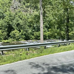
Apple Maps shows the recreation area in a slightly different location (same road, but east of the actual falls), so there was a bit of confusion when I drove here, but the falls were splendid and super easy to access. In fact, the view from the road is almost as good as the view from below the bridge, accessed by scrambling down the rocks on either side of the water. (The path on the east side looked easier to me, so that's the side I went down.) While you can get here from the east (Maps will offer two options depending on your starting point), so not attempt the eastern route without a truck or SUV and a confident driver. I left Murphy, SC at 5:30am to get to the falls early and ended up driving almost 20 miles on dirt roads with sheer drops on one side ... in the dark. Not for the squeamish. The drive through Tellico Plains is much easier, if physically longer.

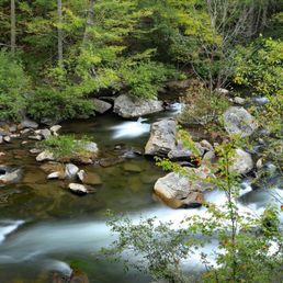
We did the Hiawassee River Train Adventure and then headed out to Tellico Plains for a few stops- on my list Bald River Falls and Baby Falls (right up the road). The massive storm that rolled through the day before meant rivers were high, water was raging and the falls were crazy! I've seen pictures of the falls at various water flow and this was mad rushing! The spray was ice cold misting across the roadway. There was a secondary fall off to the right, hard to make out in pictures because of tree cover- but much higher than the big falls. My son and I were even crazy enough to hike up the side of the falls to the (maybe) midway point and stand inches from the falling waters. Robert even reached out to touch the water. Nut. We did our insane selfies and I even did a short video with us making faces. Then- I stepped into a mud hole. Good job, I know. Worth the beautiful scenic drive in. This was about 2 hours from where we were staying in Chattanooga and an hour passed Etowah- where we had the train ride and lunch. The Cherokee Forest National Park is stunning to drive through and we enjoyed the river views along the drive. Highly recommend the detour.

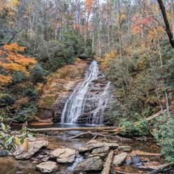
I really liked these falls! It's a great view - clear roaring waters against a backdrop of vivid lush greenery and deep black stone. (Reminds me a bit of waterfalls in Oregon. Have you ever been?..) Anyways..the falls are about 90 feet. BAM! It's a great height. The falls are super easy to descend if you want jump in for a swim. Park your car on the side of the road and scramble down the rocks. Its may about 10 feet, tops. I even did it in flip flops. I appreciate that visitors take good care of these falls. No litter or trash or cesspools of gunk. You gotta take care of nature, folks. The falls are about 11 miles from the town visitor center. Well worth the drive. Pack in a sandwich and dip your toe in the waters. Perfection.

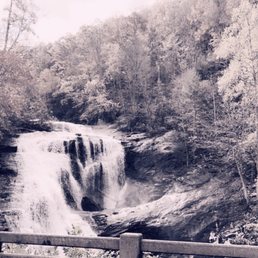


In Kentucky we have Cumberland Falls, in Tennessee they have bald River Falls. This in isn't as big as Cumberland, but it's unique in its own way. This was my second time in the area and the first time that I talked my husband into driving 6 miles down the road, to reach the falls. They were magnificent and noncommercialized. There were even people in the water, under the falls and even people at the top of the falls. We stayed put on the bridge, that overlooked the falls. It turned out to be a great photo op of the bike, with the falls in the background. If you're in the area, don't pass up the opportunity to see it. If you love waterfalls, make a trip of it. Cabins in the area are the cheapest I've ever experienced.


1 year ago
Cool 90' waterfall near the TN end of Cherohala Skyway. After a 2 year long closure, BRF just opened 3 weeks ago (May 30,2025). It had a great setting with strong cascades after much rain in the Cherokee National Forest. Since August, 2023 much of the roads, parking and the original 1933 Bridge were updated and new observation decks from the Bridge make it enjoyable even for the mobility challenged. The base of the falls and swimming holes can be accessed. I dipped my toes in and the water was warmer than expected on a hot humid (80s) day. There are 2 access roads along the Cherohala Skyway and are easy to miss. River Road is easier and seems to show up on GPS. Turkey run is NOT marked, newly paved but had a big fallen tree blocking much of the road. Parking is limited, about 15 parking spots and a steady stream of cars waiting on a weekDay afternoon. It's worth a stop but be prepared for the crowds and limited parking. No restrooms nor anything else. Leave No Trace! read more
10 months ago
3 years ago
If you're wanting a nice scenic drive (especially in the fall) and a beautiful waterfall, Bald River Falls is your place!! The waterfall itself is easy to get to as it accessible by car, but note the bridge is CLOSING in August 2023 for repairs! There is parking just past the bridge and a great place to stretch your legs and get a good view. To the left there is a rocky staircase that can take you down to the bottom of the falls. I say staircase, but that's being generous. It's more of a variety of rocks stacked and over time have settled into the earth to allow you a way to get down and up. The water is calm enough to get into on the sides, but I wouldn't recommend going too far in near the falls as the current is quite strong. read more
4 years ago
If you are anything like me, you will purposely find reason to get out and travel... even if its only a day trip. I am fortunate to live in Metro Atlanta, which puts me within a few hours of incredible mountain wilderness such as that found here in the Tellico Plains Tennessee area. A three and a half hour one way drive from home honestly sounds exhausting. But coupled with a gorgeous mountain drive, great places to stop for a bite to eat and a GORGEOUS waterfall that can be seen from the side of the road turns a 7 hour round trip drive into an adventure! We actually made Bald River Falls a detour stop as we drove home from Sevierville, TN, but my wife was so impressed with the scenery and small towns we passed through that she requested a return overnight trip "when we aren't busy!" She had me before she even spoke it. We fully intend to drive the scenic Cherohala Skyway and pass back through Blairsville to visit Pappy's Trading Post plus a number of other small town open air markets we saw along the way. The parking area is sufficient for about 15-20 cars and nearby Baby Falls las additional parking. The distance between the two is only 1/3rd of a mile. I took a side trail on the right side of Bald River Falls down to the river. If you are tenacious, you can find your way fairly close to the base of the falls. There is also a trail on the left side that seems to take you to the top of the falls. There is no hiking required to view the falls making it perfect for anyone. There are also other waterfalls within a reasonable driving distance you can hike to such as Conasauga Falls, Wildcat Falls and Falls Branch Falls. Heading towards Georgia there is also TurtleTown Creek Falls, Benton Falls and Lowry Falls Trail. [ TO MY ATLANTA YELP HIKING GROUP ] GEAR UP!!! This will be our targeted area for a fun adventure later this month, possibly around the 18th-19th! Be prepared to stay overnight so that we can get the maximum fun out of our drive!!! We've got a lot to see so lets get to it ;-) Yes that means you too Bobby G from Jacksonville! 2022 / 90 read more


7 years ago
Apple Maps shows the recreation area in a slightly different location (same road, but east of the actual falls), so there was a bit of confusion when I drove here, but the falls were splendid and super easy to access. In fact, the view from the road is almost as good as the view from below the bridge, accessed by scrambling down the rocks on either side of the water. (The path on the east side looked easier to me, so that's the side I went down.) While you can get here from the east (Maps will offer two options depending on your starting point), so not attempt the eastern route without a truck or SUV and a confident driver. I left Murphy, SC at 5:30am to get to the falls early and ended up driving almost 20 miles on dirt roads with sheer drops on one side ... in the dark. Not for the squeamish. The drive through Tellico Plains is much easier, if physically longer. read more


6 years ago
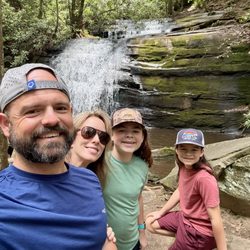
We did the Hiawassee River Train Adventure and then headed out to Tellico Plains for a few stops- on my list Bald River Falls and Baby Falls (right up the road). The massive storm that rolled through the day before meant rivers were high, water was raging and the falls were crazy! I've seen pictures of the falls at various water flow and this was mad rushing! The spray was ice cold misting across the roadway. There was a secondary fall off to the right, hard to make out in pictures because of tree cover- but much higher than the big falls. My son and I were even crazy enough to hike up the side of the falls to the (maybe) midway point and stand inches from the falling waters. Robert even reached out to touch the water. Nut. We did our insane selfies and I even did a short video with us making faces. Then- I stepped into a mud hole. Good job, I know. Worth the beautiful scenic drive in. This was about 2 hours from where we were staying in Chattanooga and an hour passed Etowah- where we had the train ride and lunch. The Cherokee Forest National Park is stunning to drive through and we enjoyed the river views along the drive. Highly recommend the detour. read more


11 years ago
I really liked these falls! It's a great view - clear roaring waters against a backdrop of vivid lush greenery and deep black stone. (Reminds me a bit of waterfalls in Oregon. Have you ever been?..) Anyways..the falls are about 90 feet. BAM! It's a great height. The falls are super easy to descend if you want jump in for a swim. Park your car on the side of the road and scramble down the rocks. Its may about 10 feet, tops. I even did it in flip flops. I appreciate that visitors take good care of these falls. No litter or trash or cesspools of gunk. You gotta take care of nature, folks. The falls are about 11 miles from the town visitor center. Well worth the drive. Pack in a sandwich and dip your toe in the waters. Perfection. read more


8 years ago
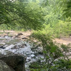
One of my favorite places to get away and relax! There are plenty of places to explore and a nice area for picnics. Be sure to check out Baby Falls just up the road from Bald River Falls too! read more


5 years ago
Bald River Falls never disappoints! Alway encourage my VRBO guest to drive down to check her out! read more

6 years ago
This was well worth a three hour drive. Just like everyone says there is hardly any parking the view can be seen from the bridge which cars drive on as well. It's kinda hard to get good pics until the traffic slows up some. Don't forget to go on down a few minutes to see baby falls as well. read more


11 years ago
In Kentucky we have Cumberland Falls, in Tennessee they have bald River Falls. This in isn't as big as Cumberland, but it's unique in its own way. This was my second time in the area and the first time that I talked my husband into driving 6 miles down the road, to reach the falls. They were magnificent and noncommercialized. There were even people in the water, under the falls and even people at the top of the falls. We stayed put on the bridge, that overlooked the falls. It turned out to be a great photo op of the bike, with the falls in the background. If you're in the area, don't pass up the opportunity to see it. If you love waterfalls, make a trip of it. Cabins in the area are the cheapest I've ever experienced. read more

6 years ago
8 years ago
Amazing place to visit, drive up to the waterfall and/or find a parking spot and explore. There are additional parking spots nearby and "National Park" style bathrooms that are basic but welcoming to those in need read more

9 years ago
Nice waterfall. You don't have to walk or hike to get to it. Drive right to it. Nice ride on the motorcycle. read more


5 years ago
10 years ago
More info about Bald River Falls
Tellico River Rd
Tellico Plains, TN 37385
Directions
(423) 253-8400
Call Now
Hours
Outdoor Amenities
Ask the Community - Bald River Falls
I looked on AllTrails and it says its a 9 miles hike. Im a disable veteran and cant hike far. Is there a way to see the falls without hiking far?
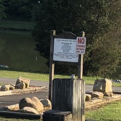
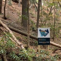
The falls will be visible from the road and bridge. There have been recent construction improvements to the bridge and parking area. The site is expected to open for vehicular traffic in the spring of 2025.
Review Highlights - Bald River Falls


Why does Yelp recommend reviews?
1 review that is not currently recommended
The reviews below are not factored into the business's overall star rating.
6 years ago
Bald River Falls - hiking - Updated July 2026
Best of Tellico Plains
People found Bald River Falls by searching for…
Hiking Trails With Waterfalls in Tellico Plains, TN
Swimming Holes in Tellico Plains, TN
Things to Do in Tellico Plains, TN
Scenic Drive in Tellico Plains, TN
Scenic Overlook in Tellico Plains, TN
Off Road Trails in Tellico Plains, TN
River Swimming in Tellico Plains, TN
Scenic Views in Tellico Plains, TN
Places to Swim in Tellico Plains, TN
Beautiful Views in Tellico Plains, TN
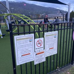
Playgrounds in Tellico Plains, TN
Attractions in Tellico Plains, TN
Photo Spots in Tellico Plains, TN
Places to Take Pictures in Tellico Plains, TN
Waterfalls in Tellico Plains, TN
Walking Trails in Tellico Plains, TN
Lookout Points in Tellico Plains, TN
Picnic Spots in Tellico Plains, TN
National Parks in Tellico Plains, TN
Easy Hikes in Tellico Plains, TN
Bike Path in Tellico Plains, TN
Secret Spots in Tellico Plains, TN
Trending Searches in Tellico Plains, TN
Boat Tours near Bald River Falls
Cliff Jumping near Bald River Falls
Day Trips near Bald River Falls
Dog Friendly Trails near Bald River Falls
Dog Swimming near Bald River Falls
Flower Fields near Bald River Falls
Kayak Rental near Bald River Falls
Off Road Trails near Bald River Falls
Picnic Spots near Bald River Falls
Playgrounds near Bald River Falls
Public Shower near Bald River Falls
Rainy Day Activities near Bald River Falls
River Swimming near Bald River Falls
Scenic Overlook near Bald River Falls
Soccer Fields near Bald River Falls
Splash Pad near Bald River Falls
State Parks near Bald River Falls
Swimming Holes near Bald River Falls
Swimming Lakes near Bald River Falls
Things To Do On A Rainy Day near Bald River Falls
Things To Do With Kids near Bald River Falls
Things To Do With Teenagers near Bald River Falls
U Pick Farms near Bald River Falls
Watch Sunset near Bald River Falls
Browse Brands
Related Searches in Tellico Plains, TN
Affordable Canoe Rental Options in Tellico Plains, Tennessee
Best Dog Hiking Trails Around Tellico Plains, Tennessee
Best Fishing Locations and Guides in Tellico Plains, Tennessee
Best Places for Horseback Riding in Tellico Plains, Tennessee
Best Waterfalls and Swimming Holes in Tellico Plains, Tennessee
Check Out Off Road Trails in Tellico Plains, Tennessee
Discover Baseball Fields Around Tellico Plains, Tennessee
Discover Dog Friendly Trails to Explore in Tellico Plains, Tennessee
Discover Popular Bike Trails in Tellico Plains, Tennessee
Discover Popular Photo Spots in Tellico Plains, Tennessee
Discover Soccer Fields in Tellico Plains, Tennessee Near You
Discover Top Nature Parks to Visit in Tellico Plains, Tennessee
Discover Top State Parks to Visit in Tellico Plains, Tennessee
Discover a Hiking Trail in Tellico Plains, Tennessee
Discover the Best Beaches in Tellico Plains, Tennessee
Discover the Best Night Hike Trails in Tellico Plains, Tennessee
Dog-Friendly Hikes With Dogs in Tellico Plains, Tennessee
Enjoy Camping Adventures Around Tellico Plains, Tennessee
Enjoy Exciting Mountain Biking Adventures in Tellico Plains, Tennessee
Enjoy Hiking Adventures in Tellico Plains, Tennessee
Enjoy Kayaking Adventures in Tellico Plains, Tennessee
Enjoy Off Leash Dog Hikes in Tellico Plains, Tennessee
Enjoy River Tubing Adventures in Tellico Plains, Tennessee
Enjoy Tent Camping Spots Around Tellico Plains, Tennessee
Enjoy the Best Picnic Spots and Ideas in Tellico Plains, Tennessee
Enjoy the Best Tubing Experiences in Tellico Plains, Tennessee
Enjoy the Best Walking Trails in Tellico Plains, Tennessee
Explore Beautiful Parks and Green Spaces in Tellico Plains, Tennessee
Explore Easy Hikes Perfect for All in Tellico Plains, Tennessee
Explore Family-Friendly Zoos and Wildlife in Tellico Plains, Tennessee
Explore Free Picnic Areas Around Tellico Plains, Tennessee
Explore Fun Activities to Do in Tellico Plains, Tennessee
Explore Parks With Pull Up Bars in Tellico Plains, Tennessee
Explore Popular Campgrounds Near Tellico Plains, Tennessee
Explore Popular Picnic Areas Around Tellico Plains, Tennessee
Explore Popular RV Parks Around Tellico Plains, Tennessee
Explore Scenic Lakes to Visit in Tellico Plains, Tennessee
Explore Secret Spots Worth Visiting in Tellico Plains, Tennessee
Explore Top Dog Parks in Tellico Plains, Tennessee Near You
Explore Top Trampoline Parks in Tellico Plains, Tennessee
Explore Top Water Parks in Tellico Plains, Tennessee Today
Explore the Best Swimming Holes Around Tellico Plains, Tennessee
Family Friendly Hiking With Kids in Tellico Plains, Tennessee
Find Beautiful Views in Tellico Plains, Tennessee
Find Cozy Camping Cabins in Tellico Plains, Tennessee
Find Picnic Tables for Outdoor Fun in Tellico Plains, Tennessee
Find Popular Ziplining Spots Around Tellico Plains, Tennessee
Find Top Dog Friendly Parks to Visit in Tellico Plains, Tennessee


