conasauga falls Photos


More like conasauga falls
Recommended Reviews - conasauga falls
Start your review...

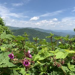
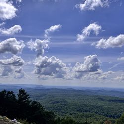
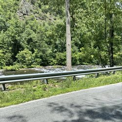
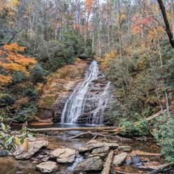
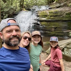
Beautiful remote falls that are worth the effort! Scenic hike in. Looks like a fun place to swim in the summer. Hike in is about one mile on steep and narrow trail that has a lot of roots and rocks. It was dry so not slippery. Would be really slippery if wet and muddy. *Drive in is a little rough once you exit highway 68 onto Witt Rd (341) for about three miles. We made it in a sedan on a dry day. Would need 4x4 if raining or snowing. Enjoy this and leave it better than you found it! read more
7 years ago
Recommend having a off road type of vehicle to get to the top of the trail. There could be better signage. Trails to the bottom can get very narrow and you will have to climb over larger rocks to get to other side of the trail. It can be harder for a shorter person. I'm 5'2 and I had to have a push from my husband over some of the rocks. Beautiful falls ! read more


7 years ago
6 years ago
6 years ago
7 years ago
More info about conasauga falls
132 Reliance Rd
Tellico Plains, TN 37385
Directions
Visit Website
https://www.fs.usda.gov
Hours
Outdoor Amenities
Ask the Community - conasauga falls


conasauga falls - hiking - Updated July 2026
Best of Tellico Plains
People found conasauga falls by searching for…
Hiking Trails With Waterfalls in Tellico Plains, TN
Things to Do in Tellico Plains, TN
Off Road Trails in Tellico Plains, TN
Scenic Drive in Tellico Plains, TN
Waterfalls and Swimming Holes in Tellico Plains, TN
Scenic Views in Tellico Plains, TN
Waterfalls in Tellico Plains, TN
Beautiful Views in Tellico Plains, TN
Easy Hikes in Tellico Plains, TN
Swimming in Tellico Plains, TN
Walking Trails in Tellico Plains, TN
Sunset View in Tellico Plains, TN
Scenic Overlook in Tellico Plains, TN
Sunrise View in Tellico Plains, TN
River Swimming in Tellico Plains, TN
Swimming Lakes in Tellico Plains, TN
Places to Take Pictures in Tellico Plains, TN
Photo Spots in Tellico Plains, TN
Dog Friendly Trails in Tellico Plains, TN
Places to Swim in Tellico Plains, TN
Off Leash Dog Hikes in Tellico Plains, TN
Yoga & Pilates in Tellico Plains, TN
Trending Searches in Tellico Plains, TN
Boat Tours near conasauga falls
Cliff Jumping near conasauga falls
Day Trips near conasauga falls
Dog Friendly Trails near conasauga falls
Kayak Rental near conasauga falls
Off Road Trails near conasauga falls
Parks For Picnics near conasauga falls
Picnic Spots near conasauga falls
Places To Swim near conasauga falls
Public Shower near conasauga falls
Public Swimming Pools near conasauga falls
River Swimming near conasauga falls
River Tubing near conasauga falls
Scenic Overlook near conasauga falls
Swimming Holes near conasauga falls
Swimming Lakes near conasauga falls
U Pick Farms near conasauga falls
Browse Articles
Browse Brands
Related Searches in Tellico Plains, TN
Affordable Canoe Rental Options in Tellico Plains, Tennessee
Best Dog Hiking Trails Around Tellico Plains, Tennessee
Best Fishing Locations and Guides in Tellico Plains, Tennessee
Best Places for Horseback Riding in Tellico Plains, Tennessee
Best Waterfalls and Swimming Holes in Tellico Plains, Tennessee
Check Out Off Road Trails in Tellico Plains, Tennessee
Discover Dog Friendly Trails to Explore in Tellico Plains, Tennessee
Discover Popular Bike Trails in Tellico Plains, Tennessee
Discover a Hiking Trail in Tellico Plains, Tennessee
Discover the Best Night Hike Trails in Tellico Plains, Tennessee
Dog-Friendly Hikes With Dogs in Tellico Plains, Tennessee
Enjoy Camping Adventures Around Tellico Plains, Tennessee
Enjoy Exciting Mountain Biking Adventures in Tellico Plains, Tennessee
Enjoy Kayaking Adventures in Tellico Plains, Tennessee
Enjoy Off Leash Dog Hikes in Tellico Plains, Tennessee
Enjoy River Tubing Adventures in Tellico Plains, Tennessee
Enjoy Tent Camping Spots Around Tellico Plains, Tennessee
Enjoy the Best Tubing Experiences in Tellico Plains, Tennessee
Enjoy the Best Walking Trails in Tellico Plains, Tennessee
Explore Beautiful Parks and Green Spaces in Tellico Plains, Tennessee
Explore Easy Hikes Perfect for All in Tellico Plains, Tennessee
Explore Fun Activities to Do in Tellico Plains, Tennessee
Explore Popular Campgrounds Near Tellico Plains, Tennessee
Explore Top Dog Parks in Tellico Plains, Tennessee Near You
Explore Top Water Parks in Tellico Plains, Tennessee Today
Explore the Best Swimming Holes Around Tellico Plains, Tennessee
Family Friendly Hiking With Kids in Tellico Plains, Tennessee
Find Beautiful Views in Tellico Plains, Tennessee
Find Cozy Camping Cabins in Tellico Plains, Tennessee
Find Popular Ziplining Spots Around Tellico Plains, Tennessee
Find Top Dog Swimming Spots in Tellico Plains, Tennessee
Find Top-Rated Waterfalls in Tellico Plains, Tennessee Now
Find the Best Parks for Picnics in Tellico Plains, Tennessee
Find the Best Playgrounds to Visit in Tellico Plains, Tennessee
Find the Best Scenic View Locations in Tellico Plains, Tennessee
Hiking Trails With Waterfalls in Tellico Plains, Tennessee
Off Leash Dog Hiking Trails in Tellico Plains, Tennessee
Plan a Scenic Drive Route Near Tellico Plains, Tennessee
Popular Fishing Spots to Explore in Tellico Plains, Tennessee
Popular Picnic Spots to Visit in Tellico Plains, Tennessee
Safe River Swimming Areas in Tellico Plains, Tennessee
Safe and Fun Parks for Kids in Tellico Plains, Tennessee
Top Hiking Trails to Explore in Tellico Plains, Tennessee
Top Running Trails to Explore in Tellico Plains, Tennessee
Top Swimming Lakes to Enjoy in Tellico Plains, Tennessee
Top Swimming Spots and Pools in Tellico Plains, Tennessee
Top-Rated Camping Sites in Tellico Plains, Tennessee
Walk Dog Friendly Hiking Trails in Tellico Plains, Tennessee