Cancel

    Open app

    Search

    Bearwallow Mountian Trail

    5.0 (1 review)

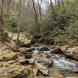
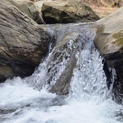
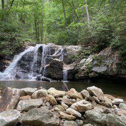
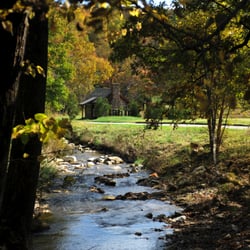
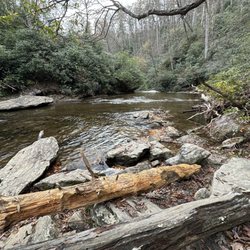
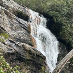
    Bearwallow Mountian Trail Photos

    More like Bearwallow Mountian Trail

    Recommended Reviews - Bearwallow Mountian Trail

    Your trust is our priority, so businesses can't pay to alter or remove their reviews. Learn more about reviews.
    Yelp app icon
    Browse more easily on the app
    Review Feed Illustration
    Photo of Andi P.
    4563
    1384
    7377

    9 months ago

    Helpful 5
    Thanks 1
    Love this 6
    Oh no 0

    Verify this business for free

    People searched for Hiking 1,452 times last month within 15 miles of this business.

    Verify this business

    Little Bradley Falls

    Little Bradley Falls

    4.4
    (7 reviews)
    14.7 mi

    Great hike and lovely waterfalls. The address is incorrect. The curve address is 5336 Holbert Cove…read moreRoad, Saluda, NC. This is as per the Polk County NC GIS and deeds to the property. Someone entered a wrong address and messed up all addresses in the area. People, if you don't know dint make it up. You're keeping lots of folks from enjoying this great area Big Bradley Falls is on the other side of the road. It is as if today Nov 2021 closed to all but permit holding hunters as the approach to the falls is very technical and challenging. You can hike the area though.

    My family and I decided to spend a weekend in North Carolina. Since we enjoy the outdoors we…read moredecided to spend a part of our time hiking. We went to Little Bradley Falls, located in Saluda, North Carolina. Due to a wildfire that happened a couple of years back some of the trials are restricted for hikers. However, you are still able to see Little Bradley Falls and explore the surrounding area. The trail is pet and kid friendly, with designated paths, so you do not have to worry about getting lost. The parking lot is more of "pull of the side of the road" style parking. It was tight, but I was able to park my SUV. Although the majority of Little Bradley Falls trail was closed, the rest of the trail was well kept, and you could visibly see the park staff was working on reopening the damaged trail. The waterfall was beautiful, there is an observation area where you can see the majestic waterfall, perfect for photos. Although the trail was well cleared, one dangerous part is you have to climb over rocks in the river to get to the other side of the trail. It wasn't that difficult, but should be considered when planning your hike to Little Bradley Falls. If you are in the Saldua North Carolina area, or want to take an easy hike with the family, I would definitely recommend taking a look into Little Bradley Falls. I hope to return in the future to complete the other trailhead that is adjacent from Little Bradley Falls.

    Photos
    The Crew (SUNDAY-5/7/23)
    The Crew (SUNDAY-5/7/23)
    Little Bradley Falls
    Gorgeous multi-tiered specimen of a waterfall approx. 50' tall

    See all

    Gorgeous multi-tiered specimen of a waterfall approx. 50' tall
    Riley Moore Falls

    Riley Moore Falls

    5.0
    (4 reviews)
    67.7 mi

    This is the best waterfall we got to visit in SC this far. After we left Reedy Branch Falls we…read moredrove here. Well, as close as we could get. I didn't realize that we couldn't drive all the way to the trailhead so we had a long hike in store due to me having to carry my toddler most of the time. I should have re-read the previous reviews before coming. My friend did help me carry her as well and for that I was very thankful. So definitely don't recommend this hike with a little one unless strapped in a carrier. Also, I don't recommend it for the elderly either. It's definitely a wilderness hike deal with roots and elevation change. In fact, it's mostly downhill on the way to the falls, but on the way back it's pretty much all uphill, which was not fun with aforementioned young child. It's about a half mile to the actual trailhead and then another 0.7 mile to the falls. That's about 2.4 miles round trip. The reason of course that my boys absolutely became enamored with this place is the large swimming hole. It is wonderful and has plenty of space. The waterfall itself is beautiful and although it's not as tall as others, its width is quite impressive. I was trying to get as close as I could and even noticed a hidden part of the falls inside of the rock structure. That was so cool!! The sand at the base and shore give it a beachy vibe. We definitely packed it in and out making sure not to leave anything behind as to preserve the area as best as possible. Needless to say we were wiped by the time we made it back to our vehicles, but we're still glad we decided to venture here. Coming back with my hubby and boys in the very near future. Happy yelping!

    I just wanted to update my 3/15/20 review below to add I've now done this hike several times, but…read moreTHIS time I had the chance to hike it with a friend who is directly related to the namesake of the waterfall... Riley Moore. Sandie is a church friend of mine and Riley Moore was her Great Great Uncle (I believe that's right). He once upon a time operated a grist mill here at the top of the falls. She's been trying to get here to see the waterfall, but couldn't find it and wanted to join us (along with her family) since I knew the way. Upon further research I discovered there are actually still remnants of the mill including visible drill holes, spikes and bolts. Thought that was pretty cool info to share! [ [ [ PREVIOUS REVIEW ] ] ] Riley Moore Falls is small in height but HUGE in personality. It's located off State Road S37-748, which is a nicely maintained gravel road where cars and trucks alike can comfortably traverse. ~~~ DIRECTIONS From Westminster, SC - DO NOT turn onto Cobb Bridge Road from Long Creek Hwy (Hwy 76) where you will see the brown & white sign pointing you in the direction of Riley Moore Falls. Our GPS had us go this way, then left onto State Road S37-748, but the road was CLOSED during our visit! INSTEAD, turn onto PU-32 also known as Rocky Fork Road. Turn left onto a gravel road near Rocky Fork Baptist Church and follow that until it dead ends @ State Road S37-748 (also known as Spy Rock Road). Turn right and drive approx. 1.4 miles (4 minutes) to 748c (aka Riley Moore Shoals Road). Park at the intersection of State Road S37-748 and 748c. DO NOT ATTEMPT TO DRIVE 748c in a car or minivan. Low clearance vehicles will find the terrain on this road to be VERY difficult to navigate without bottoming out or getting stuck. I'd also recommend 4x4 capability on wet days! There can be several deep-pocketed muddy areas after heavy rains. ~~~ THE TRAIL Once you reach the intersection of Spy Rock Rd (S37-748) and 748c, park roadside on Spy Rock, secure your vehicle and begin your hike approx. 1/2 mile down the "primitive road." IF you have a high ground clearance SUV or truck, you can drive the primitive road another half mile or so to a second parking area near the trailhead. The primitive road is VERY BUMPY  and can be muddy in spots after heavy rains, so a 4x4 is best. After reaching the second parking area, follow the marked trail on the left!!! The trail is a little over a 1/2 mile to the falls from here. The trail is fairly straightforward and easy to follow. ~~~ THE FALLS Once you reach the Chauga River, you will notice a large sandy area with plenty of room for an entire horde of hikers!!! Riley Moore Falls is not very tall (only about 12 feet), but it is very wide and has a deep base pool. PRO TIP - Bring swimwear, towels and a picnic, but be sure to pack it in and pack it out. ~~~ THINGS TO KNOW Hiking Distance: 2 miles (round trip to falls from S37-748) Difficulty of hiking 748c: All downhill to trailhead (moderate return) Difficulty of hiking trail to falls: EASY Creek Crossings: NO Elevation Gain: 357 feet Waterfall Height: Approx 12 feet Access to top of falls: NO - not without getting wet Access to base of falls: YES Pool of water @ base of Falls: YES Sitting areas @ base: YES + sandy beach RESTROOMS: NO PARKING: YES (along road) + secondary parking area closer to trailhead for trucks and high ground clearance vehicles with room for about 6 cars. ~~~ [ FINAL THOUGHTS ] A lovely waterfall in any season, but also a great spot for a summer swim. While we had the waterfall practically to ourselves during our Mid-March expedition, be advised other trail website reviews say it gets trashy & crowded in summer months. What a shame if that is true because it truly is a treasure. ENJOY! 2022 / 74 #UPDATE 178

    Photos
    Riley Moore Falls
    CREATED FROM GOOGLE MAPS
    CREATED FROM GOOGLE MAPS
    Riley Moore Falls

    See all

    Alum Cave Trail

    Alum Cave Trail

    4.9
    (41 reviews)
    62.0 mi

    Today was our second time back to Alum Cave Trail, and we did the 2.3 miles to Alum Cave Bluff and…read morethen turned back, for a total of 4.6 miles. You can go on for a total of five miles to reach Mt. Leconte, but since the weather was turning and it was starting to rain we cut our hike short. Like others, I suggest getting to this trail head early, as at 7:30 am half the parking lot was full!! We love this trail in particular for its endless water features, lots of scenic spots to take pictures, unique bridges, and the breathtaking view from the top. Even with the bad weather today, it was something spectacular watching the fog lift above the golden trees. If you haven't been, this trail is definitely worth your time and attention. You will want to wear some sturdy walking shoes for this one and maybe even bring a walking stick!!

    Gorgeous trail with diverse beauty. We did the medium length hike to the bluff and loved it. Once…read moreyou pass the cave the whole hike is pretty much going uphill so come prepared to get a workout in and wear proper shoes and bring some water. The views are great from the bluff and totally worth it. We came during the week around noon and parking lot was full so we had to park further out and walk about a half mile or so to the trail so be prepared for that or plan your time. Totally worth it! One of my favorite hikes that we did in the area. Loved being by the creek, the log crossings, the cave, the moss, the trees, and the Mountain Views. the scenery was so pretty. There is a bathroom on-site at the start of the trail in case you are wondering.

    Photos
    Alum Cave Trail
    Alum Cave Trail to Mount LeConte | Instagram: @telephonesmoothie
    Alum Cave Trail to Mount LeConte | Instagram: @telephonesmoothie
    Perfect day for an autumn scenery hike.

    See all

    Perfect day for an autumn scenery hike.
    Wildcat Rock Trail

    Wildcat Rock Trail

    4.5
    (2 reviews)
    2.2 mi

    We did this hike back in the winter and it wasn't crowded. There's a little bit of parking by the…read moretrailhead and a lot of people park along the street. If you're looking at AllTrails, we did Little Bearwallow via Wildcat Rock Trail. The trail is pretty steep and on the more strenuous side. It's 4.7 miles round trip if you follow the same path. If you only care about views, I would recommend going to the Wildcat Rock Overlook and turning around after that. It would be about 3 miles round trip. There are no views from the Little Bearwallow Summit. The Wildcat Rock Trail also continues to Bearwallow Mountain, but we didn't do that portion. I'd like to come back for it at some point.

    We were visiting Bat Cave, North Carolina. We had planned to hike Chimney Rock. As our luck would…read morehave it, the two days that we were in town, Chimney Rock was closed for maintenance. While we were driving from Asheville on our way back to Bat Cave later that day I spotted a new hiking trail head. Basically it is tucked right off the winding country highway. There is a sign, and some gravel parking. What I noticed while driving by were the cars parked there. So be on the lookout. We planned to hike it the next morning. We decided to get an early start. When we arrived before 8am, there were two cars parked in the gravel near the trail head. You start by crossing the road, you head down before (trust me) you go up the mountain. You can choose to hike just 1.1 miles to Little Bearwallow Falls. Or you can continue up to Wildcat Rock which is listed as basically 1.6 miles one way which sounds easy. But if you ask me it is straight up. The day we went it felt like we were hiking in the rain forest. We were sweating so much that sweat was dripping from our finger tips as we hiked up. I loved every minute of it. We were secluded and we were working hard. It felt so good. Once we reached Little Bearwallow Falls, we just knew that we needed to continue to the top. We needed to see something a little more spectacular. Once we reached the top to Wildcat Rock it was gorgeous. We stepped out of the foliage and we could see the valley below and the mountains in the distance. It was beautiful. We waited and we were lucky enough to see a bird soaring high above the mountain tops. It was the perfect hike for us. Strenuous yet providing the feeling of peace and accomplishment. We highly suggest checking out Wildcat Rock especially if Chimney Rock is too busy, or if money is a factor. There is no cost to enter at this trailhead unlike if you go to Chimney Rock. Also, take water.

    Photos
    Wildcat Rock Trail
    Wildcat Rock Trail
    Wildcat Rock Trail

    See all

    Secret Falls

    Secret Falls

    5.0
    (3 reviews)
    54.8 mi

    Wanna know a secret???…read more There are waterfalls all over this region of the South just waiting to be discovered. Many are known and many more are unknown. While I've been hiking this area for nearly a decade, I only recently heard about this waterfall for the first time last year (2019). A well kept local secret indeed... but y'all dun let the wrong yelper discover this waterfall and the secret is about to be let out! [ THE DRIVE ] There are a shocking amount of natural waterfalls located on private property throughout this area. Thankfully this is not one of them and it can be enjoyed by all. The gravel road to the trailhead is known as Big Creek Road. Since we were coming from the King Creek Waterfall area near Tamassee SC, GPS lead us to the eastern end of Horse Cove Road, which is also known as Bull Pen Road closer to the Chattooga River (where you pass over a cool old iron bridge). I tell you these details because if you happen to follow our driving route on a week after heavy rainfalls, you are likely to see a great number of unnamed waterfalls off in the woods. We counted 5, and only one of them was a named waterfall on Google maps (Scotsman Falls). [ THE EXPERIENCE ] We traveled along Walking Stick Road until it took a sharp right turn towards Big Creek Road. On the day we visited, there was a locked gate blocking the drive onto Big Creek Road, so we parked in a small little niche near the gate and walked about 200 yards to the Secret Falls trailhead (which is marked with a narrow sign). The trail was very muddy, but the descent was slow and steady for the majority of the half mile hike. However, it gets considerably steeper as you approach the portion of the trail leading to the base of the falls. Here you will see poorly maintained wooden timbers actings as steps.They were so poor in fact, that we opted not to use them and walked alongside them. The waterfall was raging from all the recent rain, which limited some of our photo opportunities. It is a gorgeous waterfall with picturesque cascades both above and below it. The cascades below comes as the river takes a sharp left turn just past the pool of water at the base of the falls. Accessing the upper waterfall area is easily done by using a small obvious trail off to the left just before the wooden steps. A downed tree forces you to scramble over it and around large rhododendrons that are bent over from the weight of the fallen tree. Once through the brush, you will be directly on top of the falls, so be careful and exercise good judgement. [ THINGS TO KNOW ] Hiking Distance: 1.3 miles Difficulty: Easy and family friendly (but can be muddy) Creek Crossings: YES (3) Elevation Gain: 255 feet Waterfall Height: Approx 45 feet Access to top of falls: YES Access to base of falls: YES Pool of water @ base of Falls: YES Sitting areas @ base: YES RESTROOMS: NO PARKING: YES if gate is open. [ FINAL THOUGHTS ] THE SECRET IS OUT!!! This is a great waterfall for an easy family adventure. We came in the winter, but seems this would be a great picnic spot where kids could play in the water for hours in the summer. The drive to nearby Highlands, NC is only about 6.5 miles away for plenty of food options and even more waterfall adventures. Near Highlands are a number of GREAT waterfalls with very short hiking distances including Ranger Falls, Bust Yer Butt Falls, Bridal Veil Falls, Cullasaja River Falls and our personal favorites: Glen Falls, Dry Falls, Mud Falls and Estatoah Falls (which is hidden just next to the Sky Valley Scenic Overlook). ENJOY!!! 2020 / 4

    I was somewhat surprised that there are not more reviews of this trail/waterfall. I believe that…read morethe real name of this falls is Big Shoals Falls. In his book on NC waterfalls, Kevin Adams referred to it as Secret Falls and the name seems to have stuck. For years, there was no official trail to this waterfall and the one unofficial trail which existed traversed private property. I've been visiting the area for thirty years and this (October 2021) was my first visit to this waterfall. Bottom line: It is awesome. Truly one of the more beautiful waterfalls that I've been to. I have to disagree with the previous reviewer: IMO, this trail is in horrible shape. Granted, reviews like these are entirely subjective. But I would definitely not bring young children or dogs here. When I visited, the trail was really in bad shape. The first part of the hike was fairly easy. But the farther you go, the worse the trail becomes. Erosion had taken a terrible toll. There are many rutted and washed-out areas. Some were so bad that hikers have bypassed the trail completely. The final descent to the base of the falls was the worst. Wooden steps had been constructed. But the erosion was so bad that much of the soil behind the steps had washed out making the steps all but unusable. There are two water crossings on the trail. One was a couple of planks stretched across a small branch. The other was on a split log over a somewhat larger stream. Neither was too difficult. Then again, the faint-of-heart would probably not care for either one. Trekking poles helped me on both. I was not able to find a path to the brink of the falls. I tried one crude path which seemed to be incredibly choked with rhododenron. So I gave up on getting to the top of the falls. There is a much smaller cascade downstream of the main falls. As with the brink, I could not figure out how to get to it. I visited early in the morning and had the place all to myself. The lighting wasn't terrific. I'm not sure what time or sky conditions are ideal for photography. I drove in on Rich Gap and Big Creek Roads off of Hwy 28 south of Highlands. It wasn't too bad of a drive in my 2WD F-150. But I believe that the drive out on Walking Stick Rd to Horse Cove Rd east of town was easier. If you love waterfalls, definitely put this one on your must-see list. But be aware of the fact that the hike is a challenge. Not so much due to elevation change (which is moderate) but, rather, due to the overall condition of the trail.

    Photos
    Have to walk over this water
    Have to walk over this water
    Cross the tree
    Cross the tree
    Secret Falls

    See all

    Bearwallow Mountian Trail - hiking - Updated June 2026

    Loading...
    Loading...
    Loading...