Berryessa Creek Trail Photos


You might also consider
More like Berryessa Creek Trail
Recommended Reviews - Berryessa Creek Trail
Start your review...

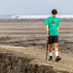
2 years ago
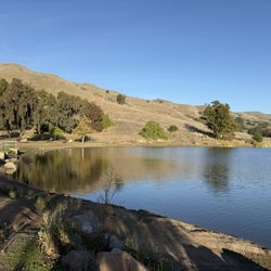
I usually go for runs at Hidden Lake Park which is attached to the Berryessa Creek Trail, but I decided to change it up this past weekend. There's nothing really special about this trail, but it was in good enough condition this past Saturday, so no complaints about the cleanliness or terrain. The paved pathway stretches from North Hillview Drive at Milpitas Town Center, past Hidden Lake Park, to N. Abel Street... a little over a mile one way, with no noticeable inclines, so definitely easy for biking or taking a stroll. And I've never seen it get crowded here. One negative is that it is disconnected at N. Milpitas Blvd with no crosswalk for pedestrians, which can cause an inconvenience if you're not willing to jaywalk and make your way through the center divide. Otherwise, it's a simple trail surrounded by neighborhood homes and the creek, of course, as well as the aforementioned Hidden Lake Park providing lovely views from above. And parking is free and easy, either directly on N. Milpitas Blvd or in the small parking lot for Hidden Lake Park. read more


14 years ago
3.99 walk/run trail. I participated in a 5K/10K fun run that took use partly along the Berryessa Creek Trail. Obviously the trail runs along a former creek bed. It was nice to discover this part of the Bay Area for exercise. read more

More info about Berryessa Creek Trail
N Jacklin Rd
Milpitas, CA 95035
Directions
Hours
Outdoor Amenities
You might also consider


Berryessa Creek Trail - hiking - Updated July 2026
Best of Milpitas
People found Berryessa Creek Trail by searching for…
Hiking Trails in Milpitas, California
Walking Trails in Milpitas, California
Running Trails in Milpitas, California
Things to Do With Kids in Milpitas, California
Easy Hikes in Milpitas, California
Fun Things to Do in Milpitas, California
Free Things to Do in Milpitas, California
Hiking With Kids in Milpitas, California
Places to Walk Around in Milpitas, California
Shaded Hike in Milpitas, California
Lakes & Ponds in Milpitas, California
Beautiful Views in Milpitas, California
Parks for Kids in Milpitas, California
Scenic View in Milpitas, California
Places to Visit in Milpitas, California
Walking Groups in Milpitas, California
Secret Spots in Milpitas, California
Great View Points in Milpitas, California
Parks With Lakes in Milpitas, California
Trending Searches in Milpitas, CA
4th Of July Fireworks near Berryessa Creek Trail
Black Owned Nail Salons near Berryessa Creek Trail
Boat Rental near Berryessa Creek Trail
Cliff Jumping near Berryessa Creek Trail
Day Trips near Berryessa Creek Trail
Dog Friendly Trails near Berryessa Creek Trail
Fireworks near Berryessa Creek Trail
Jet Ski Rental near Berryessa Creek Trail
Kayak Rental near Berryessa Creek Trail
Lakes & Ponds near Berryessa Creek Trail
Outdoor Activities near Berryessa Creek Trail
Parks For Picnics near Berryessa Creek Trail
Places To Walk Around near Berryessa Creek Trail
Public Pools near Berryessa Creek Trail
Public Shower near Berryessa Creek Trail
River Swimming near Berryessa Creek Trail
Rock Quarry near Berryessa Creek Trail
Scenic Night View near Berryessa Creek Trail
Scenic Overlook near Berryessa Creek Trail
Secluded Spots near Berryessa Creek Trail
Soccer Store near Berryessa Creek Trail
Splash Pad near Berryessa Creek Trail
Strawberry Picking near Berryessa Creek Trail
Sunrise View near Berryessa Creek Trail
Swimming Holes near Berryessa Creek Trail
Swimming Lakes near Berryessa Creek Trail
Watch Sunset near Berryessa Creek Trail
Browse Articles
Browse Nearby
BEST of Milpitas, California Coffee near Berryessa Creek Trail
BEST of Milpitas, California Things to Do near Berryessa Creek Trail
BEST of Milpitas, California Restaurants near Berryessa Creek Trail
BEST of Milpitas, California Walking Trails near Berryessa Creek Trail
BEST of Milpitas, California Parks near Berryessa Creek Trail
BEST of Milpitas, California Breakfast near Berryessa Creek Trail
BEST of Milpitas, California Hot Springs near Berryessa Creek Trail
BEST of Milpitas, California Campgrounds near Berryessa Creek Trail
BEST of Milpitas, California Sightseeing near Berryessa Creek Trail
Browse Brands
Related Searches in Milpitas, CA
Affordable Kayak Rental Services in Milpitas, California
Best Fishing Locations and Guides in Milpitas, California
Best Nature Trails for Hiking in Milpitas, California
Best Places for Horseback Riding in Milpitas, California
Best Waterfalls and Swimming Holes in Milpitas, California
Check Out Off Road Trails in Milpitas, California
Discover Dog Friendly Trails to Explore in Milpitas, California
Discover Kid Friendly Hiking Trails in Milpitas, California
Discover Scenic Hiking Trails in Milpitas, California
Discover Scenic Mountain Bike Trails Near Milpitas, California
Discover Scenic Waterfall Spots in Milpitas, California
Discover Walking Parks in Milpitas, California Near You
Discover a Hiking Trail in Milpitas, California
Discover the Best Night Hike Trails in Milpitas, California
Dog-Friendly Hikes With Dogs in Milpitas, California
Enjoy Camping Adventures Around Milpitas, California
Enjoy Exciting Mountain Biking Adventures in Milpitas, California
Enjoy Kayaking Adventures in Milpitas, California
Enjoy Tent Camping Spots Around Milpitas, California
Enjoy a Beautiful Waterfall Hike in Milpitas, California
Enjoy a Peaceful Nature Walk in Milpitas, California
Enjoy the Best Walking Path in Milpitas, California
Enjoy the Best Walking Trails in Milpitas, California
Experience Thrilling White Water Rafting in Milpitas, California
Explore Beautiful Parks and Green Spaces in Milpitas, California
Explore Easy Hikes Perfect for All in Milpitas, California
Explore Fun Activities to Do in Milpitas, California
Explore Popular Campgrounds Near Milpitas, California
Explore the Best Beach Spots in Milpitas, California
Explore the Best Boating Spots in Milpitas, California
Explore the Best Trail Options in Milpitas, California
Family Friendly Hiking With Kids in Milpitas, California
Find the Best Parks for Picnics in Milpitas, California
Find the Best Scenic View Locations in Milpitas, California
Great Places to Walk in Milpitas, California
Hike the Popular Waterfall Trail in Milpitas, California
Hiking Trails With Waterfalls in Milpitas, California
Off Leash Dog Hiking Trails in Milpitas, California
Plan a Scenic Drive Route Near Milpitas, California
Popular Outdoor Activities to Try in Milpitas, California
Popular Picnic Spots to Visit in Milpitas, California
Safe River Swimming Areas in Milpitas, California
Safe and Fun Parks for Kids in Milpitas, California
Top Climbing Spots and Gyms in Milpitas, California
Top Paddleboarding Activities in Milpitas, California
Top Running Trails to Explore in Milpitas, California
Top Swimming Lakes to Enjoy in Milpitas, California
Top Swimming Spots and Pools in Milpitas, California
People who viewed Berryessa Creek Trail also viewed
Coyote Creek Trail
21 reviews
Guadalupe River Trail
54 reviews
North San Jose
Mission Peak Trail Head
3 reviews
PG&E Trail
21 reviews
Permanente Creek Trail
8 reviews
Hike the Mallard Slough Trail - Alviso
5 reviews
Moffett Bay Trail
5 reviews
Saratoga Gap Open Space Preserve
18 reviews
New Chicago Marsh
3 reviews
Oliver W. Jones Memorial Park
7 reviews