Big Dalton Canyon Campground Photos


You might also consider


More like Big Dalton Canyon Campground
Recommended Reviews - Big Dalton Canyon Campground
Start your review...


Reviews With Photos


We came here because we were just out for a Sunday drive, lo and behold we ended up list going up the mountain it had plenty of nice views going up and I love that it passes by to reservoirs. The only thing I didn't really like was thay there is absolutely no signal around there what so ever, guess it's a good place to get lost or drop a body


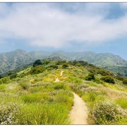
With the Colby Fire taking out both Garcia Trail and Colby Trail, it has been a bummer not being able to go hiking locally. But man, I was excited to find this hidden gem called Mystic Canyon and Punk Out Trail through Instragram Feeds. The entrance to the trail is located on Big Dalton Canyon Road, approx .5miles east of Glendora Canyon Road as you head into Angeles Forest. When you enter the trail stay to the path on the left as it splits and it will quickly begin a steep climb for approx .25miles up (this portion reminds of the steepness of Garcia Trail). The next .75 miles up is a series of steady inclined switchbacks which is very manageable to jog and run. At about the 1mile mark, you meet the intersection of Poop Out Trail, Lower Monroe Trail and Mystic Trail. Here you can rest and enjoy a nice elevated view of Glendora and surrounding area. You still can get cell phone reception at this point and a handful of hikers and bikers are in this area, which seems to be the turn around point for most that I saw. But I choose to continue to climb up and took the Lower Monroe Trail to my right. Once again this a nice steady climb up, perfect for jogging or running. Within a .25 you will hit the Punk Out Trail Marker. That is the coolest trail name ever, isn't it? From there you can decide to go the steep route up the hill or stick to the left for a steady climb up. Past the Punk Out Trail marker, it is a lonely road, so do not go unprepared without enough water or running partner. This trail is not nearly as popular or crowded as Garcia Trail or Clairemont Wilderness Trails, but it offers a good, go between of the two trails.


2 years ago
Love love love this trail!!! The stream that you walk next to makes this hike picturesque. I would recommend to all my loved ones. Very beginner friendly as well! read more


7 years ago
Short hike , pet friendly , not crowded is a big plus . Would recommend anyone looking for a place to relax with no noise just nature :) read more


11 years ago
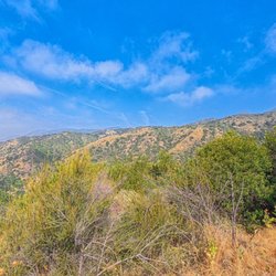
The hike to Mystic Canyon is 9.6 miles roundtrip with 2,217' elevation gain/loss. It is not a difficult hike in general, but there are a few areas that are fairly steep. The trail is wide at points and also single file with loose rocks under foot. The entire trail is without shade. At the start of the hike for about a mile, the ascension is pretty steep. But after this portion, the climb is pretty steady. Unless you choose to take Punk out Trail. Punk out Trail is clearly marked and is a detour to the right of the main path. If you want a better and more difficult workout, this is the way to go. It will also shave about 1 mile off the total trip. Once you climb the steep ridge and arrive at the landing/trail above, go right and continue up the trail to your destination. Views of the mountains and city are nice. Mt Baldy and Iron Mountain are easily seen from this vantage point. parking - free lot across from the trail head read more


7 years ago

8 years ago

12 years ago
We came here because we were just out for a Sunday drive, lo and behold we ended up list going up the mountain it had plenty of nice views going up and I love that it passes by to reservoirs. The only thing I didn't really like was thay there is absolutely no signal around there what so ever, guess it's a good place to get lost or drop a body read more


8 years ago


13 years ago
With the Colby Fire taking out both Garcia Trail and Colby Trail, it has been a bummer not being able to go hiking locally. But man, I was excited to find this hidden gem called Mystic Canyon and Punk Out Trail through Instragram Feeds. The entrance to the trail is located on Big Dalton Canyon Road, approx .5miles east of Glendora Canyon Road as you head into Angeles Forest. When you enter the trail stay to the path on the left as it splits and it will quickly begin a steep climb for approx .25miles up (this portion reminds of the steepness of Garcia Trail). The next .75 miles up is a series of steady inclined switchbacks which is very manageable to jog and run. At about the 1mile mark, you meet the intersection of Poop Out Trail, Lower Monroe Trail and Mystic Trail. Here you can rest and enjoy a nice elevated view of Glendora and surrounding area. You still can get cell phone reception at this point and a handful of hikers and bikers are in this area, which seems to be the turn around point for most that I saw. But I choose to continue to climb up and took the Lower Monroe Trail to my right. Once again this a nice steady climb up, perfect for jogging or running. Within a .25 you will hit the Punk Out Trail Marker. That is the coolest trail name ever, isn't it? From there you can decide to go the steep route up the hill or stick to the left for a steady climb up. Past the Punk Out Trail marker, it is a lonely road, so do not go unprepared without enough water or running partner. This trail is not nearly as popular or crowded as Garcia Trail or Clairemont Wilderness Trails, but it offers a good, go between of the two trails. read more


13 years ago

13 years ago
Big Dalton and Colby trails are pretty easy. Moderate to easy. Great view of the mountains and a nd overall a fun Hike. Did all trails except 3 determined to do the other ones. Great for kids where tables are set up for a picnic. read more


8 years ago
More info about Big Dalton Canyon Campground
2041 Big Dalton Canyon Rd
Glendora, CA 91741
Directions
(626) 914-8228
Call Now
Visit Website
http://www.ci.glendora.ca.us
Hours
Outdoor Amenities
Other Amenities
Ask the Community - Big Dalton Canyon Campground
Review Highlights - Big Dalton Canyon Campground
You might also consider



















Why does Yelp recommend reviews?

Big Dalton Canyon Campground - hiking - Updated September 2026
Best of Glendora
Service Offerings Nearby
People found Big Dalton Canyon Campground by searching for…
Hiking Trails With Waterfalls in Glendora, CA
Beautiful Views in Glendora, CA
Waterfalls and Swimming Holes in Glendora, CA
Free Campgrounds in Glendora, CA
Off Road Trails in Glendora, CA
Free Overnight Parking in Glendora, CA
Walking Trails in Glendora, CA
Hiking Trails Kid Friendly in Glendora, CA
Camping Cabins in Glendora, CA
Running Trails in Glendora, CA
Rv Dump Station in Glendora, CA
Trending Searches in Glendora, CA
Antiques near Big Dalton Canyon Campground
Apple Orchards near Big Dalton Canyon Campground
Apple Picking near Big Dalton Canyon Campground
Barbershop near Big Dalton Canyon Campground
Bike Shop near Big Dalton Canyon Campground
Cabins near Big Dalton Canyon Campground
Campgrounds near Big Dalton Canyon Campground
Casinos near Big Dalton Canyon Campground
Caves near Big Dalton Canyon Campground
Cliff Jumping near Big Dalton Canyon Campground
Consignment Shops near Big Dalton Canyon Campground
Crabbing Location near Big Dalton Canyon Campground
Cruising Spots near Big Dalton Canyon Campground
Dog Friendly Things To Do near Big Dalton Canyon Campground
Estheticians near Big Dalton Canyon Campground
Eyebrow Threading near Big Dalton Canyon Campground
Eyelash Extensions near Big Dalton Canyon Campground
Furniture Stores near Big Dalton Canyon Campground
Hiking near Big Dalton Canyon Campground
Kids Birthday Party near Big Dalton Canyon Campground
Lakes near Big Dalton Canyon Campground
Long Term Rv Parking near Big Dalton Canyon Campground
Makeup Artists near Big Dalton Canyon Campground
Mattresses near Big Dalton Canyon Campground
Meteor Shower near Big Dalton Canyon Campground
Mineral Hot Springs near Big Dalton Canyon Campground
Outdoor Activities near Big Dalton Canyon Campground
Parks near Big Dalton Canyon Campground
Picnic Areas near Big Dalton Canyon Campground
Public Shower near Big Dalton Canyon Campground
River Swimming near Big Dalton Canyon Campground
River Tubing near Big Dalton Canyon Campground
Rock Quarry near Big Dalton Canyon Campground
Scenic Overlook near Big Dalton Canyon Campground
Sunrise View near Big Dalton Canyon Campground
Swimming Holes near Big Dalton Canyon Campground
Teeth Whitening near Big Dalton Canyon Campground
Trailer Park near Big Dalton Canyon Campground
Browse Nearby
BEST of Glendora, California Coffee near Big Dalton Canyon Campground
BEST of Glendora, California Things to Do near Big Dalton Canyon Campground
BEST of Glendora, California Parks near Big Dalton Canyon Campground
BEST of Glendora, California Restaurants near Big Dalton Canyon Campground
BEST of Glendora, California Scenic View near Big Dalton Canyon Campground
BEST of Glendora, California Breakfast near Big Dalton Canyon Campground
BEST of Glendora, California Campgrounds near Big Dalton Canyon Campground
Browse Brands
Related Cost Guides
Related Searches in Glendora, CA
Affordable Long Term RV Parking in Glendora, California
Best Camp Locations and Facilities in Glendora, California
Best Day Camps for Children in Glendora, California
Best Dog Hiking Trails Around Glendora, California
Best Fishing Locations and Guides in Glendora, California
Best Gymnastics for Kids Activities in Glendora, California
Best Kids Camps Available in Glendora, California
Best Montessori Preschools Available in Glendora, California
Best Nature Trails for Hiking in Glendora, California
Best Places for Horseback Riding in Glendora, California
Best Summer Camps for Kids Located in Glendora, California
Browse Charming Cabins in Glendora, California
Browse Tent Camping Sites in Glendora, California
Browse Top Hotels in Glendora, California for Your Stay
Campgrounds With Cabins Available in Glendora, California
Check Out Off Road Trails in Glendora, California
Daycares With Cameras for Peace of Mind in Glendora, California
Discover Dog Friendly Trails to Explore in Glendora, California
Discover Easy Hiking Trails Near Glendora, California
Discover Free Campgrounds in Glendora, California Area
Discover Fun Toddler Parks in Glendora, California for Your Little One
Discover Kid Friendly Hiking Trails in Glendora, California
Discover Popular Bike Trails in Glendora, California
Discover Scenic Beach Camping Sites in Glendora, California
Discover Scenic Mountain Bike Trails Near Glendora, California
Discover Top State Parks to Visit in Glendora, California
Discover Walking Parks in Glendora, California Near You
Discover a Hiking Trail in Glendora, California
Discover the Best Beaches in Glendora, California
Discover the Best Fishing Lake in Glendora, California
Discover the Best Night Hike Trails in Glendora, California
Dog-Friendly Hikes With Dogs in Glendora, California
Enjoy Camping Adventures Around Glendora, California
Enjoy Kayaking Adventures in Glendora, California
Enjoy Off Leash Dog Hikes in Glendora, California
Enjoy Scenic Places to Walk in Glendora, California
Enjoy Tent Camping Spots Around Glendora, California
Enjoy a Beautiful Waterfall Hike in Glendora, California
Enjoy the Best Walking Path in Glendora, California
Enjoy the Best Walking Trails in Glendora, California
Enroll in Summer School Classes in Glendora, California
Explore After School Programs Available in Glendora, California
Explore Beautiful Parks and Green Spaces in Glendora, California
Explore Car Camping Spots and Gear in Glendora, California
Explore Easy Hikes Perfect for All in Glendora, California
Explore Free Kids Activities Near Glendora, California
Explore Free Preschools Near Glendora, California


