
Rattlesnake Peak Trail Photos


You might also consider


More like Rattlesnake Peak Trail
Recommended Reviews - Rattlesnake Peak Trail
Start your review...


Reviews With Photos


The difficulty and length of this hike varies, depending on which starting point you choose. One option is to start at mile marker 339 (before the 1ST tunnel and about 1.5 miles from the parking lot) for about 8.5 miles round trip and 3500' elevation up and back. The longer option is to continue on the trail past the 2ND tunnel. This route is about 10.5 miles round trip and 4100' elevation. Unless you enjoy bushwhacking and the potential for lots of cuts and scrapes from the brush, I would recommend taking the shorter trail. Unfortunately, our group did not. The trail is very arduous and difficult to locate at times, as the brush is overgrown and thick. GPS is helpful if you are taking the long route. The entire trail to reach the peak is essentially an ascent, and most of it is a very steep climb - very steep! You will feel like you are in reach of the peak over and over, but it just keeps going. Definitely wear long pants and use trekking poles if you have them. Most importantly, take more water than you think you need. There is no shade, and if it's a hot day, you will become dehydrated pretty quickly. The views are nice but not the most impressive. On the way back, we took the route that reaches mile marker 339. I'm so glad we did, as this route has very little high brush and it is much easier to locate the trail. However, there are still several steep climbs over hills in order to eventually descend. The descent is pretty steep much of the way down. This is a much tougher hike that I anticipated, even though I was told that it is the 2nd hardest climb in the area, only 2nd to Iron Mountain. It is great training and an exhausting workout, but I probably would not consider doing it again. tip - adventure pass required parking - small lot


This was a very challenging hike. It is pretty easy to find: from LA, take the 210 east, exit Azusa Ave, turn right on East Fork Rd (12 miles up), then drive about 3 miles and make a left on Shoemaker road, and finally drive a couple of miles until you see a yellow locked gate. That's where the trail starts. We had absolutely no issue with parking (there was just one group that was camping out there by the entrance). At the beginning of the hike, it was really hot because there is no coverage. We found some shady spots to take breaks in, but you definitely do not want to forget the sunblock! Eventually, you get to two different tunnels, which was really cool (in both senses). It was nice to get a little break from the sun and the tunnel was full of graffiti that was cool to look at. :) After the second tunnel, we turned right and hiked through a part where there's an old rusty storage tank and a little stream. At this point, we lost the trail. We did a little exploring in order to figure it out (this part was fun but kind of saddening because it was a hiccup in our hike). My boyfriend noticed that the trail had been washed out and it continued up higher than where we were. It is a little dangerous getting up this part, but we made it back onto the trail. (If you choose to do this, I recommend using the roots to climb). We continued on the hike, but it seemed that there were a few other parts that had been washed out. Also, many plants were overgrown and poked us (make sure to wear long pants). We had to turn around because we ran out of water, but we really liked the hike nevertheless because of how challenging it was. It is a difficult hike if you continue past the second tunnel. If you're looking for a moderate hike, it is also nice to just hike to the stream after the second tunnel. There are a lot of cool spots for pictures!


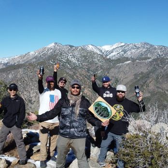
Nonvemnous hike, I survived :) Rattlesnake peak is known to be "Baby Iron Mountain" and it certainly lives up to that reputation. As who doesn't love babies? Right? Lol, I love, love babies! From the gate, it's about a mile hike on a flat dirt road to the trailhead ...then get ready for an awesome climb and a bit of rock scrambling at the top! Hiking the loop, my iwatch clocked in at 11 miles with an elevation gain of 3,984ft. The descent, after the summit, is so so very overgrown (bleh). Make sure to wear long sleeves, pants as I was pretty scratched up on my slightly exposed areas, from trekking through all the brush. So many sharp yucca plants here too. Descent is sandy with areas that are pretty slippery -I had no shame in using my microspikes then. During this hike, you're exposed to the elements most of the time (not much shade) - so best to do this hike during winter or colder weather. Bring hat, sunscreen, sunnies (sunglasses), hiking poles, water and I wear gloves (to protect myself from the cold, sun and brush). Don't forget to share here on Yelp, your "witch-jump," "broomstick stick jump," at the summit, lol. I had enough energy to muster up a couple jumps for this photo at the peak ...and I have confidence that you will too. Happy adventuring to you !!! Stay safe and healthy (mind, body and soul) out there :) read more


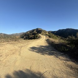
Me and my group did this on Saturday (1/8/22). This can be enjoyable if you go in knowing that it will test you and not enjoyable if you are just looking to be in nature and for great views...there are much easier hikes that can provide you with that ****Warning***** I have hiked hundreds of times and I found this hike to be very difficult so only do this hike if you are prepared for this. It is considered to be the 2nd hardest hike in the Angeles National Forest...only Iron Mountain being harder and this hike is often called Baby Iron or Iron Mountain's Little Brother...there are longer hikes but because of the incline, terrain, etc...it doesn't get much harder in the LA area; Location- north of Azusa, take HWY 39 and turn R on East Fork Rd...the same way as you would go for the Bridge to Nowhere hike...but you make a left on Shoemaker Rd about a mile or two before; the parking lot is pretty big and since this hike is difficult and not a lot of people do it the parking is not croweded; you need an Adventure Pass displayed Trail- you hike for about 1.5 miles on a pretty wide fire road that has gradual incline that is pretty easy...keep an eye out to the left for the small trail that you will want to take...if you get to the first of two tunnels you have gone too far...from all the reviews I have read it is better to do the out and back and not the loop that would include the tunnels since beyond the tunnels the trail is overgrown and not enjoyable; after you take the small trail to the left the next 3 miles will be very slow going with really steep rocky sections and some ups and downs where the dirt is loose and it is easy to slip and fall and this is especially true when coming back down. There will be some false summits and just some areas of up and down that will really slow the pace down. The trail is exposed and because it is so hard it would be wise to pick the right time of year and weather conditions and of course to start the hike at a good time (EARLY) Peak- the views at the peak are really good since you have views to the south looking toward the nearby cities, to the west and Mt. Wilson, to the east and Iron Mtn and Baldy and to the north and Baden-Powell; there was the metal 39 martker and a box with hiking stickers on it but no wooden sign when we were there Difficulty- extremely strenuous Distance- about 8.5 miles Elevation Gain- about 4,300 ft Peak Elevation- about 5,800 ft Duration- there are some people who breeze through this in 5 hrs but I think most people will need about 7-10 hrs depending on how many breaks you take and how long you spend at the peak Tips- wear shoes with good grips (hiking or trail running shoes); wear layers for different weather conditions but also to stay covered up for the bushes and plants that you may bump up against; bring lots of water(3-4L), and trekking poles read more


9 years ago
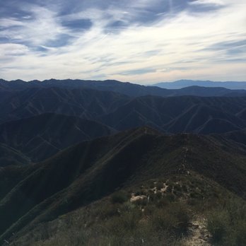
Tough. Sketchy. Rough. Fun and worth it! Great views as you ascend higher. Highly recommend trekking poles and legit hiking shoes as there is lots of loose dirt and gravel. Especially heading back down, I was literally on my hands trying not to slip. I only do this hike 1-2 times a year as it's a very tough hike, mentally and physically. I would recommend doing this on a cool day as there is zero shade. Of course bring lots of water as you'll be sweating your ass off. You will need to hike about 1.1 miles from the parking lot to reach the start of the trail on your left. If you passed the first tunnel you've gone too far. Look for the mile marker 3.39 and you'll see a little steep hill that climbs up to start. Level: Hard Parking: Small lot, Adventure Pass required but they never come here to check it so park at your own risk. Distance: About 9 miles RT Elevation gain 3500. read more



11 years ago
The difficulty and length of this hike varies, depending on which starting point you choose. One option is to start at mile marker 339 (before the 1ST tunnel and about 1.5 miles from the parking lot) for about 8.5 miles round trip and 3500' elevation up and back. The longer option is to continue on the trail past the 2ND tunnel. This route is about 10.5 miles round trip and 4100' elevation. Unless you enjoy bushwhacking and the potential for lots of cuts and scrapes from the brush, I would recommend taking the shorter trail. Unfortunately, our group did not. The trail is very arduous and difficult to locate at times, as the brush is overgrown and thick. GPS is helpful if you are taking the long route. The entire trail to reach the peak is essentially an ascent, and most of it is a very steep climb - very steep! You will feel like you are in reach of the peak over and over, but it just keeps going. Definitely wear long pants and use trekking poles if you have them. Most importantly, take more water than you think you need. There is no shade, and if it's a hot day, you will become dehydrated pretty quickly. The views are nice but not the most impressive. On the way back, we took the route that reaches mile marker 339. I'm so glad we did, as this route has very little high brush and it is much easier to locate the trail. However, there are still several steep climbs over hills in order to eventually descend. The descent is pretty steep much of the way down. This is a much tougher hike that I anticipated, even though I was told that it is the 2nd hardest climb in the area, only 2nd to Iron Mountain. It is great training and an exhausting workout, but I probably would not consider doing it again. tip - adventure pass required parking - small lot read more


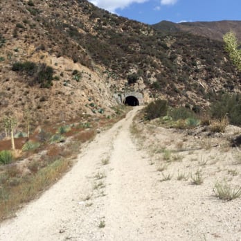
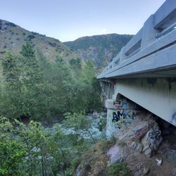
This was a very challenging hike. It is pretty easy to find: from LA, take the 210 east, exit Azusa Ave, turn right on East Fork Rd (12 miles up), then drive about 3 miles and make a left on Shoemaker road, and finally drive a couple of miles until you see a yellow locked gate. That's where the trail starts. We had absolutely no issue with parking (there was just one group that was camping out there by the entrance). At the beginning of the hike, it was really hot because there is no coverage. We found some shady spots to take breaks in, but you definitely do not want to forget the sunblock! Eventually, you get to two different tunnels, which was really cool (in both senses). It was nice to get a little break from the sun and the tunnel was full of graffiti that was cool to look at. :) After the second tunnel, we turned right and hiked through a part where there's an old rusty storage tank and a little stream. At this point, we lost the trail. We did a little exploring in order to figure it out (this part was fun but kind of saddening because it was a hiccup in our hike). My boyfriend noticed that the trail had been washed out and it continued up higher than where we were. It is a little dangerous getting up this part, but we made it back onto the trail. (If you choose to do this, I recommend using the roots to climb). We continued on the hike, but it seemed that there were a few other parts that had been washed out. Also, many plants were overgrown and poked us (make sure to wear long pants). We had to turn around because we ran out of water, but we really liked the hike nevertheless because of how challenging it was. It is a difficult hike if you continue past the second tunnel. If you're looking for a moderate hike, it is also nice to just hike to the stream after the second tunnel. There are a lot of cool spots for pictures! read more


8 years ago
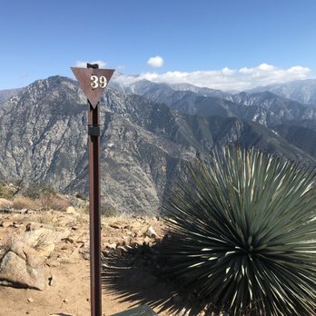
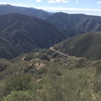
This is a difficult hike. It is easy getting to the parking lot but hard locating the trailhead. Follow other reviewers directions. There are very steep portions which make it quite challenging on the descent. As mentioned by others, bring hiking poles or you may be Falls me on your butt a few times. Also, bring a lot of water, try to start early and go on a cool breezy day. Good luck read more



11 years ago
More info about Rattlesnake Peak Trail
Ask the Community - Rattlesnake Peak Trail
You might also consider


















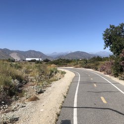
Rattlesnake Peak Trail - hiking - Updated September 2026
Best of Azusa
People found Rattlesnake Peak Trail by searching for…
Trending Searches in Azusa, CA
Apple Orchards near Rattlesnake Peak Trail
Apple Picking near Rattlesnake Peak Trail
Barbershop near Rattlesnake Peak Trail
Bike Shop near Rattlesnake Peak Trail
Blowout near Rattlesnake Peak Trail
Casinos near Rattlesnake Peak Trail
Cliff Jumping near Rattlesnake Peak Trail
Consignment Shops near Rattlesnake Peak Trail
Cruising Spots near Rattlesnake Peak Trail
Dog Friendly Things To Do near Rattlesnake Peak Trail
Estheticians near Rattlesnake Peak Trail
Eyelash Extensions near Rattlesnake Peak Trail
Furniture Stores near Rattlesnake Peak Trail
Hiking Trails With Waterfalls near Rattlesnake Peak Trail
Kids Birthday Party near Rattlesnake Peak Trail
Lookout Points near Rattlesnake Peak Trail
Makeup Artists near Rattlesnake Peak Trail
Mattresses near Rattlesnake Peak Trail
Parks near Rattlesnake Peak Trail
Picnic Areas near Rattlesnake Peak Trail
Places To Take Pictures near Rattlesnake Peak Trail
Public Shower near Rattlesnake Peak Trail
Rock Quarry near Rattlesnake Peak Trail
Scenic Night View near Rattlesnake Peak Trail
Scenic Overlook near Rattlesnake Peak Trail
Sugaring near Rattlesnake Peak Trail
Sunrise View near Rattlesnake Peak Trail
Swimming Holes near Rattlesnake Peak Trail
Browse Articles
Browse Nearby
BEST of Azusa, California Coffee near Rattlesnake Peak Trail
BEST of Azusa, California Restaurants near Rattlesnake Peak Trail
BEST of Azusa, California Things to Do near Rattlesnake Peak Trail
BEST of Azusa, California Walking Trails near Rattlesnake Peak Trail
BEST of Azusa, California Breakfast near Rattlesnake Peak Trail
BEST of Azusa, California Parks near Rattlesnake Peak Trail
BEST of Azusa, California Campgrounds near Rattlesnake Peak Trail
Browse Brands
Related Searches in Azusa, CA
Best Dog Hiking Trails Around Azusa, California
Best Fishing Locations and Guides in Azusa, California
Best Nature Trails for Hiking in Azusa, California
Best Places for Horseback Riding in Azusa, California
Check Out Off Road Trails in Azusa, California
Discover Dog Friendly Trails to Explore in Azusa, California
Discover Easy Hiking Trails Near Azusa, California
Discover Kid Friendly Hiking Trails in Azusa, California
Discover Popular Bike Trails in Azusa, California
Discover Scenic Mountain Bike Trails Near Azusa, California
Discover Walking Parks in Azusa, California Near You
Discover a Hiking Trail in Azusa, California
Discover the Best Night Hike Trails in Azusa, California
Dog-Friendly Hikes With Dogs in Azusa, California
Enjoy Camping Adventures Around Azusa, California
Enjoy Kayaking Adventures in Azusa, California
Enjoy Off Leash Dog Hikes in Azusa, California
Enjoy Scenic Places to Walk in Azusa, California
Enjoy Tent Camping Spots Around Azusa, California
Enjoy a Beautiful Waterfall Hike in Azusa, California
Enjoy the Best Walking Path in Azusa, California
Enjoy the Best Walking Trails in Azusa, California
Explore Beautiful Parks and Green Spaces in Azusa, California
Explore Easy Hikes Perfect for All in Azusa, California
Explore Fun Activities to Do in Azusa, California
Explore Popular Campgrounds Near Azusa, California
Explore Popular Dog Walking Trails in Azusa, California
Explore Top Dog Parks in Azusa, California Near You
Family Friendly Hiking With Kids in Azusa, California
Find Beautiful Views in Azusa, California
Find Parks and Recreation Activities in Azusa, California
Find Top Dog Friendly Parks to Visit in Azusa, California
Find Top-Rated Waterfalls in Azusa, California Now
Find the Best Parks for Picnics in Azusa, California
Hiking Trails With Waterfalls in Azusa, California
Off Leash Dog Hiking Trails in Azusa, California
Popular Outdoor Activities to Try in Azusa, California
Popular Picnic Spots to Visit in Azusa, California
Popular Waterfall Hiking Trails in Azusa, California
Safe River Swimming Areas in Azusa, California
Safe and Fun Parks for Kids in Azusa, California
Top Hiking Trails to Explore in Azusa, California
Top Playgrounds for Kids to Enjoy in Azusa, California
Top Running Trails to Explore in Azusa, California
Top Swimming Lakes to Enjoy in Azusa, California
Top Swimming Spots and Pools in Azusa, California
Top-Rated Camping Sites in Azusa, California


