Azusa River Wilderness Park Photos


You might also consider
More like Azusa River Wilderness Park
Recommended Reviews - Azusa River Wilderness Park
Start your review...

Reviews With Photos - Azusa River Wilderness Park


Easy hike that's not crowded. It's a 3 mile trail out & back, but only hiked about a mile before I turned around. Great for kids & dogs. Will hike again to finish the loop. You're able to see the river, but there is no access down. Plenty of parking at the start. The center before this has public restrooms, but it only has hand sanitizer.
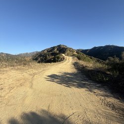
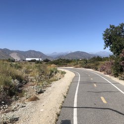
Truly a hidden gem! I say hidden because the entrance is not marked from the road and I had driven by many times without knowing this park existed. The trail follows the San Gabriel river up the canyon but does not provide river access. It's well maintained for hiking purposes, not too strenuous, but keep an eye out for landslides. Parking is free in the parking lot. Perfect trail for solo, friend and family hiking and especially for nature lovers.


Now, you may have heard of BBQ Becky, I have a new name to add to pantheon of folks who go over board on authority and make no apologies for being block heads. I call him "ATV Larry" and I see that he was mentioned in a post earlier doing the EXACT same thing he did with us. Well, my wife and I decided to try a new place to hike in Azusa Canyon and found this wonderful gem. We arrived around 3:45p or so and began the hike. It's an easy one, pretty straight forward just keep on the fire road. But be warned, you will come to a fork in the road that is paved.. do not go down the paved road. It is private property. Just stay on the fire road. As we came to the fork we looked down to see a couple of guys with fishing gear and a guy driving on an ATV. My wife and I are thinking "hey this is like an outdoor paradise" we can come fish or just ride ATVs, this is a real cool place. Welp, what we were actually watching was ATV Larry kicking out the fishermen of his property and telling them that he was calling the sheriff. We thought that it was odd but it did not involve us so we moved on and continued our hike. Well, about 10 min later like a bat outta hell, ATV Larry rides up to my wife and I to tell us that the "park is closed" and "he called the sheriff" and we better "get out and not get wrapped up into it". I said okay fine and he looked at me and said "all right, you said Ok so turn around start moving out" and he then waits for me to turn and walk before he grinds down the trail on his ATV. Would you know it! The LA County Sheriff truck arrives right as we were making our way back into the parking lot. At this point, my wife needed some clarity and walked up to the Sheriff to ask when the park was closed and the Sheriffs say at sundown. Of course, ATV Larry is leaning next to the truck door looks over at us and agrees with the sheriffs nodding his head saying yea it closes at sundown! Wow! What a knucklehead! We told the sheriffs that ATV Larry was telling everyone that the park was closed and left it at that. ATV Larry is not a park ranger, he is not a sheriff, my assumption is that he is a property owner or the care taker of the private property along the river. So sure, I get that he is protective of the property but he goes overboard thinking that he has some authority over people in a public park. He has no authority to kick people out of the park especially when it is 4:50pm way before sundown begins! Just remember, if you see his ATV a-commin' just give him a wave or a friendly nob but don't think for a minute he makes the rules on when the public park is opened or closed. Would give this place 5 stars if it wasn't for ATV Larry ruining our first time experience at this beautiful park.


3 months ago
Update this is for the west Azusa river not the east Azuza river. Attached is a photo of the east Azusa river read more


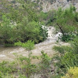
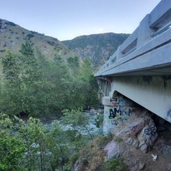
At the foot of the San Gabriel Mountains is a pathway into the canyons, bordered by towering cliffs and twinkling streams. It's the first right turn before you enter the national forest. Unadorned and easy to overlook, it's perhaps the most uncomplicated way to access the natural beauty of this area. Before you go, you need to prepare by...doing absolutely nothing. No Adventure Pass needed. Parking is free, marked by sizeable signage saying El Encanto. It's the remnant of a restaurant built in the 1920's that ceased operations about 20 years ago. A well-maintained trail curves gently down the canyon. On the descending path, you'll be accompanied by the bubbling river, lofty mountain views, and in typical LA fashion, colorful graffiti. It's an easy 2 mile hike round-trip with moderate elevation change. Though it says no river access at the trailhead, you'll actually end up right next to the river for the latter portion of the hike. The trail ends in a quiet oasis, sleek gray stones of assorted shapes and sizes protruding above the water like a floating zen garden. The Azusa Wilderness Park is still in its nascent stages of development by the Watershed Conservation Authority, a local public entity dedicated to planning and maintaining open spaces. Expanded trails, dining services, and interactive nature experiences are part of the plan. Exciting as all that is, for the moment, simplicity also carries its own tranquil charm. read more


3 months ago
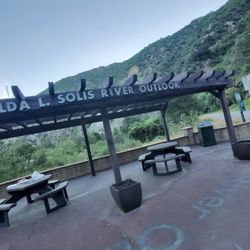
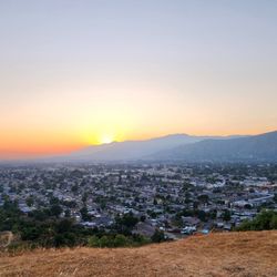
Definitely a 4.25 star trail. From a 5 mile to a 10 mile long trail - for walks, jogs runs bikes, skating- etc for individuals to groups ... and family outings... the scenic views are gorgeous...inspiring. from low to higher elevation, the trails are clean and encouraging. The river flows can be heard and seen. As the trail advances up north, less and less people and homes can be seen or heard...Just nature... as a runner, I was drawn to the beauty of the sounds and scenery. Along the way, wooden gateways lined the trails, rest stops along the way and up to the turn around point. Only thing missing is restrooms but I can see why. Have fun enjoy. Parking can be done at the wilderness point ...Last stop by north or park along the roadway , along the housing track. read more


2 months ago
5 months ago
This is a great view of the San Gabriel mountains the river is right next to you and it is only about a couple miles there was a landslide but it was cleared you are supposed to go in the water but you can reach it very easily read more

2 months ago
3 months ago
1 year ago
11 months ago
I loved it, quiet and beautiful place! Best for summer gatherings, river walks, hikes, etc. read more

3 years ago
Easy hike that's not crowded. It's a 3 mile trail out & back, but only hiked about a mile before I turned around. Great for kids & dogs. Will hike again to finish the loop. You're able to see the river, but there is no access down. Plenty of parking at the start. The center before this has public restrooms, but it only has hand sanitizer. read more


Truly a hidden gem! I say hidden because the entrance is not marked from the road and I had driven by many times without knowing this park existed. The trail follows the San Gabriel river up the canyon but does not provide river access. It's well maintained for hiking purposes, not too strenuous, but keep an eye out for landslides. Parking is free in the parking lot. Perfect trail for solo, friend and family hiking and especially for nature lovers. read more


1 year ago
What beauty and a great place to explore nature it has a lovely bike trail that goes all the way from Aziza to the borderline of Los Angeles County and Orange County read more


3 years ago
2 years ago
Great place to go in Los Angeles after a rainy season and guards were very informative. However many things blocked off due to danger July 1,2024. read more


3 years ago
7 years ago
Now, you may have heard of BBQ Becky, I have a new name to add to pantheon of folks who go over board on authority and make no apologies for being block heads. I call him "ATV Larry" and I see that he was mentioned in a post earlier doing the EXACT same thing he did with us. Well, my wife and I decided to try a new place to hike in Azusa Canyon and found this wonderful gem. We arrived around 3:45p or so and began the hike. It's an easy one, pretty straight forward just keep on the fire road. But be warned, you will come to a fork in the road that is paved.. do not go down the paved road. It is private property. Just stay on the fire road. As we came to the fork we looked down to see a couple of guys with fishing gear and a guy driving on an ATV. My wife and I are thinking "hey this is like an outdoor paradise" we can come fish or just ride ATVs, this is a real cool place. Welp, what we were actually watching was ATV Larry kicking out the fishermen of his property and telling them that he was calling the sheriff. We thought that it was odd but it did not involve us so we moved on and continued our hike. Well, about 10 min later like a bat outta hell, ATV Larry rides up to my wife and I to tell us that the "park is closed" and "he called the sheriff" and we better "get out and not get wrapped up into it". I said okay fine and he looked at me and said "all right, you said Ok so turn around start moving out" and he then waits for me to turn and walk before he grinds down the trail on his ATV. Would you know it! The LA County Sheriff truck arrives right as we were making our way back into the parking lot. At this point, my wife needed some clarity and walked up to the Sheriff to ask when the park was closed and the Sheriffs say at sundown. Of course, ATV Larry is leaning next to the truck door looks over at us and agrees with the sheriffs nodding his head saying yea it closes at sundown! Wow! What a knucklehead! We told the sheriffs that ATV Larry was telling everyone that the park was closed and left it at that. ATV Larry is not a park ranger, he is not a sheriff, my assumption is that he is a property owner or the care taker of the private property along the river. So sure, I get that he is protective of the property but he goes overboard thinking that he has some authority over people in a public park. He has no authority to kick people out of the park especially when it is 4:50pm way before sundown begins! Just remember, if you see his ATV a-commin' just give him a wave or a friendly nob but don't think for a minute he makes the rules on when the public park is opened or closed. Would give this place 5 stars if it wasn't for ATV Larry ruining our first time experience at this beautiful park. read more

4 years ago
Anyone know how to get here EXACTLY ? My dad would take us here when I was younger and I want to go now but don't remember I asked him but things look much different than they did 20 yrs ago so his description doesn't help much . read more


7 years ago
Short hike :) but nicely if you don't want to walk too much and still Enjoy . There is loose dirt and rocks to get to the end of the hike . Must be very careful read more

2 years ago
5 years ago
Love this place! It's heaven! The fact that there is no phone service is a plus. Definitely a beautiful place! Pick up after yourself! Family friendly! read more


3 years ago
Really enjoyed this hike. The parking lot is free and the hike runs along the river with awesome views of the canyon. Seemed like they were working on the trail when I went and looks like they have future plans for expansion. Very peaceful. read more


7 years ago
very short and quick hike, the hike does state that there is no river access and to go to the one with river access you have to continue onto the highway but when we got to the end there was a small section with the river. very hot and very little shade, it's all dirt as well. read more


6 years ago
6 years ago
7 years ago
More info about Azusa River Wilderness Park
100 Old San Gabriel Canyon Rd
Azusa, CA 91702
Directions
Hours
Indoor Amenities
Outdoor Amenities
Ask the Community - Azusa River Wilderness Park
Hi can you swim in the river?
I believe at this part of the river no, there are signs telling you that you can drive up to a higher part of the mountain for access to swim
Does anyone know if the park is now open?
Idk about now but I went a few months ago
Hi is open is good for the kids?
Most of it looks like it should be ok for kids.
Review Highlights - Azusa River Wilderness Park
You might also consider


Why does Yelp recommend reviews?
5 reviews that are not currently recommended
The reviews below are not factored into the business's overall star rating.
7 years ago
4 months ago
2 years ago
3 years ago
3 years ago
Azusa River Wilderness Park - hiking - Updated July 2026
Best of Azusa
People found Azusa River Wilderness Park by searching for…
Campgrounds in Azusa, California
River Swimming in Azusa, California
Free Things to Do in Azusa, California
Beautiful Views in Azusa, California
Hiking Trails in Azusa, California
Fishing Spots in Azusa, California
Walking Trails in Azusa, California
Swimming Lakes in Azusa, California
Free Beach Parking in Azusa, California
Dog Friendly Things to Do in Azusa, California
Atv Rentals/Tours in Azusa, California
Scenic Spots in Azusa, California
Places to Take Pictures in Azusa, California
Scenic View in Azusa, California
Off Road Trails in Azusa, California
Dog Parks in Azusa, California
Running Trails in Azusa, California
Waterfall Hike in Azusa, California
Abandoned Buildings in Azusa, California
Fishing With Kids in Azusa, California
Trending Searches in Azusa, CA
4th Of July Fireworks near Azusa River Wilderness Park
Black Owned Nail Salons near Azusa River Wilderness Park
Boardwalk near Azusa River Wilderness Park
Boat Rental near Azusa River Wilderness Park
Cliff Jumping near Azusa River Wilderness Park
Day Trips near Azusa River Wilderness Park
Dog Friendly Beaches near Azusa River Wilderness Park
Fireworks near Azusa River Wilderness Park
Fishing Spots near Azusa River Wilderness Park
Free Picnic Areas near Azusa River Wilderness Park
Jet Ski Rental near Azusa River Wilderness Park
Kayak Rental near Azusa River Wilderness Park
Kids Activities Outdoor near Azusa River Wilderness Park
Lakes near Azusa River Wilderness Park
Lakes & Ponds near Azusa River Wilderness Park
Off Road Trails near Azusa River Wilderness Park
Outdoor Activities near Azusa River Wilderness Park
Outdoor Basketball Courts near Azusa River Wilderness Park
Places To Walk Around near Azusa River Wilderness Park
Public Beaches near Azusa River Wilderness Park
Public Pools near Azusa River Wilderness Park
Public Shower near Azusa River Wilderness Park
River Swimming near Azusa River Wilderness Park
Rock Quarry near Azusa River Wilderness Park
Running Trails near Azusa River Wilderness Park
Scenic Night View near Azusa River Wilderness Park
Scenic Overlook near Azusa River Wilderness Park
Secluded Spots near Azusa River Wilderness Park
Soccer Store near Azusa River Wilderness Park
Splash Pad near Azusa River Wilderness Park
Strawberry Picking near Azusa River Wilderness Park
Sunrise View near Azusa River Wilderness Park
Swimming Holes near Azusa River Wilderness Park
Swimming Lakes near Azusa River Wilderness Park
Things To Do With Kids near Azusa River Wilderness Park
View Fireworks near Azusa River Wilderness Park
Watch Sunset near Azusa River Wilderness Park
Browse Nearby
BEST of Azusa, California Coffee near Azusa River Wilderness Park
BEST of Azusa, California Restaurants near Azusa River Wilderness Park
BEST of Azusa, California Things to Do near Azusa River Wilderness Park
BEST of Azusa, California Parks near Azusa River Wilderness Park
BEST of Azusa, California Lakes near Azusa River Wilderness Park
BEST of Azusa, California Breakfast near Azusa River Wilderness Park
BEST of Azusa, California Campgrounds near Azusa River Wilderness Park
Browse Brands
Related Searches in Azusa, CA
Best Nature Trails for Hiking in Azusa, California
Best Off Leash Dog Parks in Azusa, California
Best Parks for Parties and Events in Azusa, California
Best Water Parks for Kids in Azusa, California
Check Out Great Playgrounds in Azusa, California
Discover Baseball Fields Around Azusa, California
Discover Beautiful Garden Spots in Azusa, California
Discover Fun Toddler Parks in Azusa, California for Your Little One
Discover Lakes & Ponds to Explore in Azusa, California
Discover Popular Photo Spots in Azusa, California
Discover Scenic Bike Paths in Azusa, California
Discover Soccer Fields in Azusa, California Near You
Discover Top Nature Parks to Visit in Azusa, California
Discover Top State Parks to Visit in Azusa, California
Discover Walking Parks in Azusa, California Near You
Discover the Best Beaches in Azusa, California
Discover the Best Kids Park Spots in Azusa, California
Enjoy the Best Picnic Spots and Ideas in Azusa, California
Enjoy the Best Walking Trails in Azusa, California
Explore Easy Hikes Perfect for All in Azusa, California
Explore Family-Friendly Zoos and Wildlife in Azusa, California
Explore Free Picnic Areas Around Azusa, California
Explore Parks With Pull Up Bars in Azusa, California
Explore Popular Campgrounds Near Azusa, California
Explore Popular Picnic Areas Around Azusa, California
Explore Popular RV Parks Around Azusa, California
Explore Scenic Lakes to Visit in Azusa, California
Explore Top Dog Parks in Azusa, California Near You
Explore Top Water Parks in Azusa, California Today
Explore the Best Trail Options in Azusa, California
Find Parks and Recreation Activities in Azusa, California
Find Top Dog Friendly Parks to Visit in Azusa, California
Find Top Skate Parks in Azusa, California for All Skill Levels
Find a Park With BBQ Pits in Azusa, California
Find the Best Parks BBQ Grills in Azusa, California
Find the Best Parks for Picnics in Azusa, California
Have Fun at a Splash Pad in Azusa, California
Indoor Playgrounds to Explore in Azusa, California
Locate Tennis Courts Around Azusa, California
Parks With Basketball Courts for Games in Azusa, California
Picnic Areas With BBQ Pits Available in Azusa, California
Play at a Splash Pad Park in Azusa, California
Popular Children Playgrounds to Visit in Azusa, California
Popular Places to Take Pictures in Azusa, California
Top Hiking Trails to Explore in Azusa, California
Top Running Trails to Explore in Azusa, California
Top Swimming Lakes to Enjoy in Azusa, California
Top-Rated Basketball Courts to Play at in Azusa, California
Browse Articles
People who viewed Azusa River Wilderness Park also viewed
El Encanto Trail Hike
9 reviews
Bonnie Cove
25 reviews
Monrovia Canyon Park
329 reviews
Big Dalton Canyon Campground
12 reviews
Lewis Falls
8 reviews
Mystic Canyon Hiking Trail
23 reviews
Santa Fe Dam Recreation Area
246 reviews
Frank G Bonelli Regional Park
330 reviews
South Hills Park
26 reviews
Mt. Bliss
23 reviews