Cancel

    Open app

    Search

    Blalock Wildlife Sanctuary

    5.0 (1 review)

    Blalock Wildlife Sanctuary Photos

    You might also consider

    Recommended Reviews - Blalock Wildlife Sanctuary

    Your trust is our priority, so businesses can't pay to alter or remove their reviews. Learn more about reviews.
    Yelp app icon
    Browse more easily on the app
    Review Feed Illustration

    2 months ago

    Helpful 3
    Thanks 1
    Love this 4
    Oh no 0

    You might also consider

    Verify this business for free

    People searched for Parks 314 times last month within 15 miles of this business.

    Verify this business

    Devil's Punchbowl Natural Area - Devil's Chair Trail signage

    Devil's Punchbowl Natural Area

    4.6(137 reviews)
    5.5 mi

    It is so beautiful and amazing. The view is surreal. When…read moreyou go into the nature center and visit the snakes and beetles it's cool but then you walk out to an observatory type deck and it's breathtaking!

    I've been hiking in this area for a few years. I started out with the short loop trail then…read moreadvanced to the Devil's Punchbowl trail, and then yesterday completed the Devil's Chair trail. I didn't know about the Chair trail until recently. I found that with the short loop trail, since it was reasonably close to the ranger station, the reception was okay. While hiking the Devil's Punchbowl trail there was hardly any reception. I have Verizon as my carrier. The Devil's Chair Trail had great reception. I was able to periodically text my family and update them, letting them know I was okay. When hiking I use Spotify and ensure my songs are downloaded so even offline I can listen to music. This also works well when I want to listen to Audiobooks I've downloaded. The Chair trail was quiet, there wasn't anyone else on the trail or even much wildlife besides lizards and some insects. It wasn't bad at all. The trail was pretty well maintained with some areas needing extra support. Shout-out to the employees who ensured the steep cliffs and the Devil's Chair Trail were safe to walk on. The Chair itself is on a rock so someone had to get there and install the fencing for safety. Thank you, whoever you are! As with many other trails in Southern California there is some fire damage. Some fallen trees. This trail has A LOT of rocks so step gingerly and don't roll your ankles. Most of the trail is not covered so sunscreen/sunblock and proper gear is really important. The trail is roughly 3-5 hours. I clocked about 3 hours 55 minutes moving time on Strava but 4 hours 28 minutes total on AllTrails. I stopped a bit to catch my breath, get water and just observe nature. Everyone says it's a 7 mile trail. I'm not sure what I did but it was 9 miles for me. I am blessed to have been able to enjoy it.

    Photos
    Devil's Punchbowl Natural Area - Good times positive vibes

    Good times positive vibes

    Devil's Punchbowl Natural Area
    Devil's Punchbowl Natural Area - Rounded Rock

    See all

    Rounded Rock

    Islip Saddle

    Islip Saddle

    4.5(6 reviews)
    2.2 mi

    Beautiful hike near the intersection of the 2 and the 39. Parking lot and pristine trails are…read morewell-maintained. Well worth the drive up from the Los Angeles basin. Check traffic, weather and fire status; the forest is extremely flammable at the moment. Bring water, snacks and first aid kit. An Adventure Pass is required to park within Angeles National Forest. Be prepared for a work-out and some beautiful views.

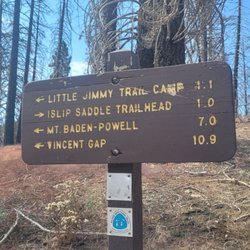
    This is a strong 4 star hike...near Mount Baden-Powell and similar in many ways. Use the All Trails…read moreapp to get directions. Parking and the trailhead is on Hwy 2. We took the 210 to the 2 Hwy near La Canada Flintridge and it took us about 50 mins and 40 miles of twists and turns while sharing the road with motorcycles and high performance cars that are testing their cars handling. You will pass the parking area for Switzer Falls (see my review for that one) and you will pass the Red Box parking area you can use to do the Strawberry Peak hike (see my review haha) and still will need to continue on Angeles Crest Hwy for about 25 more minutes. If you want you can continue tpass the main parking area for the Islip saddle about one mile to the east and find some parking on the side of the highway that will allow you to take a shortcut trail that connects with the main trail but is about .4 miles shorter, so .8 miles RT...you can see the start of the trail near the metal barrier blocking any traffic on the access road. The first .6 miles is pretty steep and then you connect to the main trail and head left to the Little Jimmy Campground which is 1.1 miles and pretty flat. When you reach the campground it gets a bit confusing with intersecting trails. Don't stop here, continue on for about 1.5 miles to reach the Mt. Islip peak. The 3rd mile is the steepest and you will gain about 550 ft and pass the 8,000 ft elevation level and come to a fork in the trail that is well marked and you will make a right to go about .2 miles to the peak. It was 3.2 miles to the peak and 6.4 miles RT using the shortcut starting area that I mentioned in the first paragraph. At the top is the ruins of a small structure, some concrete squares, and a plastic and metal box with some notebooks. There is no sign with the name and elevation of the peak but it is about 8,250 ft. above sea level. There are some great views, not quite as great as Baden-Powell. This is a moderate hike, definitely not hard. We completed the hike in 2.5 hrs with no running. There are parts that are exposed to the sun, but equal amounts that have shade. I loved that we only came across 6 total people while hiking. I just hate that it takes so long to get here and especially the amount of driving the incredibly curvy Hwy 2.

    Photos
    Islip Saddle - Natural spring

    Natural spring

    Islip Saddle
    Islip Saddle

    See all

    Last Chance Canyon - Around our camping side

    Last Chance Canyon

    5.0(1 review)
    41.8 mi

    Just a few comments on the local Mojave area around Edwards, not on this specifically posted…read more(business)location. Although the posted commentary of the first reviewer certainly sounds typical, I'd somewhat question the comment about hot nights in the Mojave. My personal experience has been that typically, about 4 PM every day, a strong wind comes up across the Mojave and temps usually can drop over 50 degrees from day to night. North of Edwards, in the eastern reaches of California City, there used to be (not sure if still there) a long dirt road-trail across the desert, that one might drive, knowing that you were traversing the old and famous 20 mule-team Borax Trail, from Death Valley to the railhead at Mojave. (See: http://home.earthlink.net/~cyberkiwi/desertexploration/trborax.htm) East of Edwards, there is an area famous for Hot-Air Ballooning. South of Edwards, east of Lancaster, off a desert road, a hillside encropment, host an open mine entrance, with old tracks and an unsafe old wooden ladder, that descends into the almost vertical depths of the old mine, only to find the bottom-of-the-shaft filled with water. A friend once slowly descended into the water, to find a horizontal water-filled shaft with air-pockets under the roof. (Not recommended!) If you can access Edwards itself, South Edwards may yet have traces of the old Edwards Sled-Track, on which the Astronauts rode a rocket-sled across the desert, to experience G-forces. The track was moved to Holloman AB, New Mexico years ago. Along the south rim of Rogers Dry Lake Bed, are the old remaining buildings and roads of the original Edwards, nee Muroc Army Air Station, made famous in air-flight history, with famous names like Chuck Yeager, X-1 rocket ship and more. Just walking through this area, when the wind blows, one can almost feel the winds of history! And finally (here), there is the famous Edwards Rocket Base, on the ridge overlooking Rogers Dry Lake, somewhat south-east of Edwards. Here is a website (link) to another website with a quote that 'paints-a-magnificent-picture', of the time-and-place of Rocket Base in history, as told in the Foreword to an online Hollywood Documentary screenplay. Enjoy! http://www.fiwd.org/Reality.htm

    Photos
    Last Chance Canyon
    Last Chance Canyon - Just beautiful and great experience for few days

    Just beautiful and great experience for few days

    Last Chance Canyon

    See all

    Rainbow Bridge Via Pacific Crest Trail

    Rainbow Bridge Via Pacific Crest Trail

    4.8(4 reviews)
    31.9 mi

    The Pacific Crest Trailhead - Mojave River Forks End of Road serves as a significant access point…read moreto the iconic Pacific Crest Trail (PCT) in Southern California. Situated at an elevation of 923 meters in the Mojave Desert region, this trailhead marks a unique intersection where the vast wilderness of the PCT meets the end of California Highway 173. It is a crucial gateway for exploring the diverse landscapes of the San Bernardino Mountains foothills and the unique desert environment. Visitors consistently highlight this trailhead as the most accessible starting point for reaching the popular Deep Creek Hot Springs, making it a favored destination for hikers. The opportunity to experience a distinctive desert section of the Pacific Crest Trail, with its scenic Deep Creek Canyon and lush riparian vegetation, is another major draw. The convenience of a wide parking area at the end of the paved road also contributes to its popularity among those looking for day hikes or shorter excursions on the PCT. Before setting out, hikers should be prepared for a creek crossing within about a mile of the trailhead, as Deep Creek must be forded. While often shallow or dry, especially during certain times of the year, water levels can rise significantly after rain or snowmelt, potentially requiring an alternative parallel track near the dam. The trailhead offers ample free parking at the dead-end of Highway 173, making it easily reachable by passenger vehicle. This trailhead is ideal for hiking and trail running, particularly for those aiming for the Deep Creek Hot Springs, which is typically a 12-mile out-and-back journey. The arid desert climate suggests that spring and fall offer the most comfortable conditions for exploration, avoiding the extreme heat of summer or potential high waters in winter. Its location also provides convenient access to nearby amenities at Mojave River Forks Regional Park, including camping and recreational opportunities at Silverwood Lake.

    i love this trail, but do it on a cloudy day, wont recommend hiking this on a hot day because…read moretheres no shade the whole time. and pls. pick up after your pet. parking is kinda sketchy too. so take the risk. Other than that love the bridge at the end of the trail!

    Photos
    Rainbow Bridge Via Pacific Crest Trail
    Rainbow Bridge Via Pacific Crest Trail
    Rainbow Bridge Via Pacific Crest Trail

    See all

    Blue Ridge Trail

    Blue Ridge Trail

    4.7(15 reviews)
    16.5 mi

    Gorgeous trail in an area of the forest that is recovering from the Bridge Fire in 2024. While it's…read moreshocking to see so many burnt trees, it's also cool to see signs of life emerging from the ashes. There were many pine seedlings to be found along the trail and lots of wildflowers called "fire-followers" that actually require and benefit from the fire to bloom. To find the trailhead, look for the Big Pines Visitor Center. The parking lot for the trail is right across the street and the standard Adventure Pass is required to park in this lot (thank goodness, it is not part of the Mountain High Ski Resort cabal, so you don't have to buy the "Big Pines" parking pass as well.) It was a bit tricky to find the actual trailhead, as it's a few feet away from the parking lot. The parking lot does have restrooms as well as ADA parking available. The trail itself is very well maintained and offers stunning views. It's pretty much uphill all the way to the Blue Ridge Campsite and (of course) downhill all the way back. It's mostly in the shade but can get warm, so make sure you have plenty of water and snacks. Look for fungi, mariposa lilies, butterflies, squirrels and birds. Highly recommended!

    The good: I came on a Tuesday and it was completely empty…read moreand serene. We came with our almost 3 year old but we carried him most of the time. The trail was mostly shaded and there were creeks with running water. We saw blue jays, chipmunks, squirrels, woodpecker and other birds. It was breezy with nice views of the mountains and far out in the canyon areas. The bad: We didn't get to finish the trail because we had a toddler. I think there were only 2 parking spots. I am not sure if there were other areas you can park. It was just on the dirt by the campgrounds sign. The interesting: Lots of the trees were burnt and fallen over. We saw red plants and some interesting mushroom growing on the trees. Some areas of the trail are more narrow with a sloping hill off to the side so be careful if you're coming with kids.

    Photos
    Blue Ridge Trail
    Blue Ridge Trail - It was 27 degrees at the start of the hike

    It was 27 degrees at the start of the hike

    Blue Ridge Trail - Little pinecones on a stump...I thought it looked cute

    See all

    Little pinecones on a stump...I thought it looked cute

    Dawson Gap to Throop Peak

    Dawson Gap to Throop Peak

    5.0(3 reviews)
    10.7 mi

    August 2021: I have now completed this hike twice since May 2021 and more than likely this will…read morebecome a once a month to once every other month adventure. It is demanding but, still good for newcomers who want to bump their, say - Griffith Park adventures up a few notches and not drive to the Sierras.

    This is actually called Dawson Saddle to Throop Peak. But you can really bag quite a few peaks in…read morethis route. Just google map Dawson Saddle to Throop Peak and it should take you to the correct location as it worked for me. It's nearby Vincent Gap area to hike to Baden-Powell. You need an adventure pass when parking and there is no restroom in this area. So plan accordingly. The trail to Throop Peak was nice and short. It's light traffic so you won't see a lot of hikers like you would on the Baden-Powell hike. Most people will make it a nice 6 mile round trip from Dawson Saddle to Throop Peak, then to Mount Hawkins. But you can also add more miles and connect to Mount Burnham and Baden-Powell. So you can definitely make this a short hike to a long hike pending which route you want to take. I think you can even go further out to like South Mount Hawkins and Mount Islip if you have time. The trail is straightforward. Once you reach the ridge, you will see a PCT sign. If you go left, that is to Mount Burnham and Baden-Powell. You want to go right towards Little Jimmy Campground. You will see a split with no posted sign. Go right to Throop Peak, if you stay left, that's PCT to Little Jimmy Campground and to Mount Hawkins. The view from Throop Peak is beautiful. Once done, someone mention there is a trail that will meetup back on PCT. But I could find it, so i went back down the same trail and hop back onto the PCT trail. The trail is easy to follow till you get to another split. The trail going right and downhill, that's PCT. The trail going left up the hill, that's to Mount Hawkins. The view at Mount Hawkins is nice, there isn't a plaque like Throop Peak has, but I found a pile of rocks that previous hikers posted when on top of Mount Hawkins. You will hike back down the way you came up for a nice 6 mile RT. I would suggest a map of the area, just in case. I like naturalatlas.com As always pack accordingly to the weather and have fun.

    Photos
    Dawson Gap to Throop Peak - Throop Peak

    Throop Peak

    Dawson Gap to Throop Peak
    Dawson Gap to Throop Peak

    See all

    Blalock Wildlife Sanctuary - parks - Updated August 2026

    Loading...
    Loading...
    Loading...