Chimney Tops Trail Photos


You might also consider
More like Chimney Tops Trail
Recommended Reviews - Chimney Tops Trail
Start your review...

Reviews With Photos

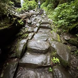
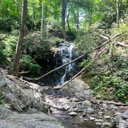
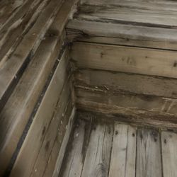
The Chimney Tops trail is located 6.9 miles south of the Sugarlands Visitor Center in Great Smokey Mountains National Park. It is listed as a moderately difficult trail and it is one of the most popular trails in the park. I saw cars stretch from the parking lot to a mile down the mountain during peak hiking times. On November 23, 2016, two juvenile males started a fire by throwing lit matches along the trail. A hiker on the trail caught them on camera. The park service decided not to put out the fire, instead containing it, and on November 28th, aided by a drought and wind, the fire exploded resulting in the death of fourteen people and injuries to one hundred and seventy six people. Eighteen thousand acres were burned including eleven thousand acres in the National Park. Two thousand four hundred and sixty structures were destroyed. The fire ended up costing more than 500 million dollars. Before the fire was put out it threatened to engulf Gatlinburg and Pigeon Forge. The trail was closed for a year and the pinnacle of the mountain is still closed. The park service constructed a new observation platform a quarter mile from the summit. The trail is 3.3 miles round trip which does not seem like very long but it was all up the mountain. At the parking lot I met a man told me he considered the trail a 9 out of 10. Another woman coming down told me it was the hardest thing she had ever done. I started the trail thinking I would give up if I needed to but with sheer determination and a fair bit of pain I made it to the top. The first part of the trail follows the waters of Road Prong Creek. You cross over several bridges where people swim in the cascading waters. Once you cross the last bridge is where the real challenge begins as you ascend straight up the mountain. As bad as it was, it would have been even worse if the Trails Forever crew had not installed the 367 rock steps weighing 300 pounds each! They redesigned unsafe parts of the trail and improved the drainage. Without their work the trail would have been extremely eroded and dangerous. The trail to the top is a combination of dirt trail and steps. What is cool about the hike is that everyone on the trail encourages each other to keep going. I don't care how fit people looked going up the mountain, everyone was huffing and puffing. Unfortunately for me the sky opened up about 1/3 mile from the top. Lightning struck the ground not far from me and cold rain poured down. I was about to give up and go back down when a woman went past me on the way to the top and I said screw it, I came too far to give up now. I continued up in the pouring rain to arrive to a hazy view of the chimney formation and Mount LeConte and Mount Kephart. The view was nothing like it would have been on a clear day. The Cherokee name for Chimney Tops is Duniskwalgunyi, or "forked antler", because of its resemblance to the deer antlers. There is a Cherokee legend about a medicine man who found monstrous reptiles at the top of the mountain. Unfortunately the mountain Gods were against me that day. I was so wet that I couldn't even dry off the camera lens on my iPhone. I thought my phone would be ruined. Three days later and I can still feel it in my legs. The hike took me two hours and 22 minutes over 3.57 miles. I did an elevation gain of 1.035 feet. Even though the view wan't all that I hoped it would be I am proud of myself for making it up there. On the way down the mountain I ran into a group of three guys going back for a second time because they lost their car keys. When it started raining they got separated from their keys and were combing the mountain for them. I hope they found them because I still feel awful for them.

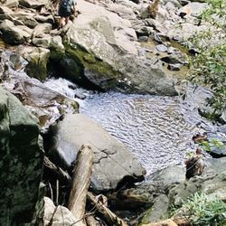
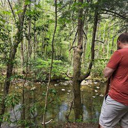
The family came here to boulder along the stream and play with the little ones in the various pools. The water temperature was in the mid 60s so very refreshing. A short while later I stepped away and pulled on my running shoes determined to run to Chimney Tops 1.7 miles, and 22 minutes later at 1.5 miles it all came to a screeching halt due to a closed gate which turned me away from climbing up the rocky precipice of the "Chimney". Climbed 1260 ft from 3475 to 4728 ft over the 1.5 miles. I did see hikers on the chimney but they had clearly bypassed this gate, an unwarranted move. The trail had log stairs and rock stairs along the way. It was breathtaking. Look forward to finishing this segment again when it is all open.

I was disappointed when I got to the top. Partially because the chimney part of the trail was closed and also because the views from the not closed section was mehhh. After doing hikes like Charlie's Bunion it's just not as good. The trail was also overrun with people which I'm good with because most hikers are friendly and respectful but then we had teenagers screaming and cussing the entire way. Acting like fools, and fell off the trail at one point. They hiked out posted the closed area, we could see them climbing around out at the base of the Chimney it was just a serious accident waiting to happen. The trail was easy, mostly stairs and a wide well worn path. At least until the part where the trail was closed. I don't know what that part of the trail is like or how difficult it might be. For me, as an avid hiker who hikes to have some peaceful time to myself and to marvel at awesome views this trail was a disappointment.

Sometimes you strive to be something in life that you know you just aren't. For me, that's a hiker. I've always wanted to be that person who hiked every Saturday and was just really outdoorsy and did that kind of thing. I took my first hike yesterday. And concluded that even though it was amazingly beautiful, I am definitely not a hiker. It was steep and painful. Putting my own misery aside. The students I took on this hike loved it and once we finally made it to the top, it made the miserable trip up worth it. If you are a hiker, I would recommend this trail. If you aren't a hiker, like me, run away.

WHEW! What a climb, but so totally worth every single step! I checked my Apple Watch halfway through and to my surprise my heart rate was around 160. I would consider myself a pretty athletic and in-shape person but this trail is no joke folks. It's around 4 miles total and a straight incline! It started out mild crossing a few bridges with great photo ops and quickly turned into an uphill battle against me and my physical fitness. Don't let that scare you away though, reaching the top was well worth my near asthma induced death. I would climb it all over again no doubt about it! If you're visiting the Smoky Mountains this is a trail you gotta experience.

I have been hiking Chimney Tops since my kids were little and recently went back with my daughter. It is the first time I have been back since the fires and they closed the last part of the trail. So you can no longer actually go to the "Chimneys". It is still a great, challenging hike and any day I can spend in the mountains is a good day. I only bring it down 1 star as you can no longer finish out the trail and must end at a nice graded overlook versus going to the top.


SO WORTH IT! It's a long long hike that will take you hours round trip but the view at the end is phenomenal. And at the very end, you get the opportunity to climb up a mountain. Yes climb, not hike. In other words, it's about 1.5-2 hour hike followed by a 20-30 min climb. It's pretty scary at the end, I felt like I was rock climbing without a harness. And if you fall or slip, you're in trouble. The view at the end can't be put in words. This is a must if you're physically capable of doing it. You'll thank me. Tip: try not to look down too much while you're climbing. just concentrate on hand/foot placement and you should make it to the top. good luck!

1 year ago
Will make it brief: this is a lovely hike, slippery when wet (which is often, it rains a lot) - take your time so you don't slip (I did, and it HURT). There are a LOT of stairs, and when it's humid you will need to stop for breaks along the way. The final view is closed from fires but they have a reconstructed viewpoint near the end that is gorgeous - the views of the mountainside are stunning. Overall - would do again, but it's a relatively difficult hike because of the uphill climb so come prepared! read more


2 years ago
This is a busy trail. Go early to avoid crowds. It is short but steep so if you don't normally workout or hike it may be difficult. The view is pretty. It's an out and back not a loop. read more

This is a STEEP hike, and if you get there after 10:00a it is going to be filled with tourists who are not slightly prepared for an actual hike. Good news for tourists, or anyone not wanting to get to the very top is that in the first 1/2 mile or so there are some lovely views with bridges over rapids and large boulders. If you do make it to the top, you'll be rewarded with some beautiful views and- depending on the season because the very end of the trail is closed in winter- an awesome hike up the chimney rock. read more


The Chimney Tops trail is located 6.9 miles south of the Sugarlands Visitor Center in Great Smokey Mountains National Park. It is listed as a moderately difficult trail and it is one of the most popular trails in the park. I saw cars stretch from the parking lot to a mile down the mountain during peak hiking times. On November 23, 2016, two juvenile males started a fire by throwing lit matches along the trail. A hiker on the trail caught them on camera. The park service decided not to put out the fire, instead containing it, and on November 28th, aided by a drought and wind, the fire exploded resulting in the death of fourteen people and injuries to one hundred and seventy six people. Eighteen thousand acres were burned including eleven thousand acres in the National Park. Two thousand four hundred and sixty structures were destroyed. The fire ended up costing more than 500 million dollars. Before the fire was put out it threatened to engulf Gatlinburg and Pigeon Forge. The trail was closed for a year and the pinnacle of the mountain is still closed. The park service constructed a new observation platform a quarter mile from the summit. The trail is 3.3 miles round trip which does not seem like very long but it was all up the mountain. At the parking lot I met a man told me he considered the trail a 9 out of 10. Another woman coming down told me it was the hardest thing she had ever done. I started the trail thinking I would give up if I needed to but with sheer determination and a fair bit of pain I made it to the top. The first part of the trail follows the waters of Road Prong Creek. You cross over several bridges where people swim in the cascading waters. Once you cross the last bridge is where the real challenge begins as you ascend straight up the mountain. As bad as it was, it would have been even worse if the Trails Forever crew had not installed the 367 rock steps weighing 300 pounds each! They redesigned unsafe parts of the trail and improved the drainage. Without their work the trail would have been extremely eroded and dangerous. The trail to the top is a combination of dirt trail and steps. What is cool about the hike is that everyone on the trail encourages each other to keep going. I don't care how fit people looked going up the mountain, everyone was huffing and puffing. Unfortunately for me the sky opened up about 1/3 mile from the top. Lightning struck the ground not far from me and cold rain poured down. I was about to give up and go back down when a woman went past me on the way to the top and I said screw it, I came too far to give up now. I continued up in the pouring rain to arrive to a hazy view of the chimney formation and Mount LeConte and Mount Kephart. The view was nothing like it would have been on a clear day. The Cherokee name for Chimney Tops is Duniskwalgunyi, or "forked antler", because of its resemblance to the deer antlers. There is a Cherokee legend about a medicine man who found monstrous reptiles at the top of the mountain. Unfortunately the mountain Gods were against me that day. I was so wet that I couldn't even dry off the camera lens on my iPhone. I thought my phone would be ruined. Three days later and I can still feel it in my legs. The hike took me two hours and 22 minutes over 3.57 miles. I did an elevation gain of 1.035 feet. Even though the view wan't all that I hoped it would be I am proud of myself for making it up there. On the way down the mountain I ran into a group of three guys going back for a second time because they lost their car keys. When it started raining they got separated from their keys and were combing the mountain for them. I hope they found them because I still feel awful for them. read more


6 years ago
The family came here to boulder along the stream and play with the little ones in the various pools. The water temperature was in the mid 60s so very refreshing. A short while later I stepped away and pulled on my running shoes determined to run to Chimney Tops 1.7 miles, and 22 minutes later at 1.5 miles it all came to a screeching halt due to a closed gate which turned me away from climbing up the rocky precipice of the "Chimney". Climbed 1260 ft from 3475 to 4728 ft over the 1.5 miles. I did see hikers on the chimney but they had clearly bypassed this gate, an unwarranted move. The trail had log stairs and rock stairs along the way. It was breathtaking. Look forward to finishing this segment again when it is all open. read more


7 years ago
I was disappointed when I got to the top. Partially because the chimney part of the trail was closed and also because the views from the not closed section was mehhh. After doing hikes like Charlie's Bunion it's just not as good. The trail was also overrun with people which I'm good with because most hikers are friendly and respectful but then we had teenagers screaming and cussing the entire way. Acting like fools, and fell off the trail at one point. They hiked out posted the closed area, we could see them climbing around out at the base of the Chimney it was just a serious accident waiting to happen. The trail was easy, mostly stairs and a wide well worn path. At least until the part where the trail was closed. I don't know what that part of the trail is like or how difficult it might be. For me, as an avid hiker who hikes to have some peaceful time to myself and to marvel at awesome views this trail was a disappointment. read more


8 years ago
Sometimes you strive to be something in life that you know you just aren't. For me, that's a hiker. I've always wanted to be that person who hiked every Saturday and was just really outdoorsy and did that kind of thing. I took my first hike yesterday. And concluded that even though it was amazingly beautiful, I am definitely not a hiker. It was steep and painful. Putting my own misery aside. The students I took on this hike loved it and once we finally made it to the top, it made the miserable trip up worth it. If you are a hiker, I would recommend this trail. If you aren't a hiker, like me, run away. read more


7 years ago
WHEW! What a climb, but so totally worth every single step! I checked my Apple Watch halfway through and to my surprise my heart rate was around 160. I would consider myself a pretty athletic and in-shape person but this trail is no joke folks. It's around 4 miles total and a straight incline! It started out mild crossing a few bridges with great photo ops and quickly turned into an uphill battle against me and my physical fitness. Don't let that scare you away though, reaching the top was well worth my near asthma induced death. I would climb it all over again no doubt about it! If you're visiting the Smoky Mountains this is a trail you gotta experience. read more


6 years ago
I have been hiking Chimney Tops since my kids were little and recently went back with my daughter. It is the first time I have been back since the fires and they closed the last part of the trail. So you can no longer actually go to the "Chimneys". It is still a great, challenging hike and any day I can spend in the mountains is a good day. I only bring it down 1 star as you can no longer finish out the trail and must end at a nice graded overlook versus going to the top. read more


Ok. This is my favorite hike so far. This is rated difficult and for good reason it is straight up! But such a beautiful hike and the trail is exceptionally clear. I averages 24 mins per mile. Beautiful views and a really relaxing hike! read more


SO WORTH IT! It's a long long hike that will take you hours round trip but the view at the end is phenomenal. And at the very end, you get the opportunity to climb up a mountain. Yes climb, not hike. In other words, it's about 1.5-2 hour hike followed by a 20-30 min climb. It's pretty scary at the end, I felt like I was rock climbing without a harness. And if you fall or slip, you're in trouble. The view at the end can't be put in words. This is a must if you're physically capable of doing it. You'll thank me. Tip: try not to look down too much while you're climbing. just concentrate on hand/foot placement and you should make it to the top. good luck! read more


8 years ago
Favorite hike near Gatlinburg,TN! Sadly the top cliffs are closed due to the forest fires. It's still a great hike with beautiful views! Very steep, wouldn't suggest to new hikers. read more


9 years ago
10 years ago
10 years ago
10 years ago
More info about Chimney Tops Trail
Ask the Community - Chimney Tops Trail
Review Highlights - Chimney Tops Trail
You might also consider


Why does Yelp recommend reviews?
1 review that is not currently recommended
The reviews below are not factored into the business's overall star rating.
9 years ago
Chimney Tops Trail - hiking - Updated June 2026
Best of Gatlinburg
People found Chimney Tops Trail by searching for…
Off Road Trails in Gatlinburg, Tennessee
Rock Climbing in Gatlinburg, Tennessee
Swimming Holes in Gatlinburg, Tennessee
Watch Sunset in Gatlinburg, Tennessee
Hiking Trails in Gatlinburg, Tennessee
Parks in Gatlinburg, Tennessee
Scenic View in Gatlinburg, Tennessee
Caves in Gatlinburg, Tennessee
Things to Do in Gatlinburg, Tennessee
Photo Spots in Gatlinburg, Tennessee
Scenic Overlook in Gatlinburg, Tennessee
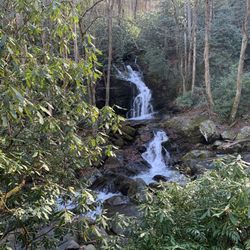
Waterfall in Gatlinburg, Tennessee
Running Trails in Gatlinburg, Tennessee
Beautiful Views in Gatlinburg, Tennessee
Sunrise View in Gatlinburg, Tennessee
River Swimming in Gatlinburg, Tennessee
Visitor Centers in Gatlinburg, Tennessee
Walking Trails in Gatlinburg, Tennessee
Playgrounds in Gatlinburg, Tennessee
Secret Spots in Gatlinburg, Tennessee
Free Campgrounds in Gatlinburg, Tennessee
Swimming Lakes in Gatlinburg, Tennessee
Trending Searches in Gatlinburg, TN
Black Owned Nail Salons near Chimney Tops Trail
Boat Rental near Chimney Tops Trail
Cliff Jumping near Chimney Tops Trail
Creeks near Chimney Tops Trail
Day Trips near Chimney Tops Trail
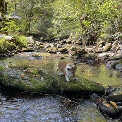
Dog Friendly Things To Do near Chimney Tops Trail
Dog Friendly Trails near Chimney Tops Trail
Easy Hikes near Chimney Tops Trail
Fishing Spots near Chimney Tops Trail
Jet Ski Rental near Chimney Tops Trail
Kayak Rental near Chimney Tops Trail
Lakes & Ponds near Chimney Tops Trail
Off Road Trails near Chimney Tops Trail
Outdoor Activities near Chimney Tops Trail
Pick Your Own Farms near Chimney Tops Trail
Picnic Spots near Chimney Tops Trail
Public Shower near Chimney Tops Trail
River Swimming near Chimney Tops Trail
Rock Quarry near Chimney Tops Trail
Scenic Night View near Chimney Tops Trail
Scenic Overlook near Chimney Tops Trail
Secluded Spots near Chimney Tops Trail
Soccer Store near Chimney Tops Trail
Splash Pad near Chimney Tops Trail
Star Gazing near Chimney Tops Trail
Strawberry Picking near Chimney Tops Trail
Sunrise View near Chimney Tops Trail
Swimming Holes near Chimney Tops Trail
Swimming Lakes near Chimney Tops Trail
Watch Sunset near Chimney Tops Trail
Browse Nearby
Browse Brands
Related Searches in Gatlinburg, TN
Affordable Bike Repair Services in Gatlinburg, Tennessee
Affordable Bike Tune Up Services in Gatlinburg, Tennessee
Affordable Kayak Rental Services in Gatlinburg, Tennessee
Best Dog Hiking Trails Around Gatlinburg, Tennessee
Best Electric Bike Rental Services in Gatlinburg, Tennessee
Best Fishing Locations and Guides in Gatlinburg, Tennessee
Best Lookout Points to Visit in Gatlinburg, Tennessee
Best Nature Trails for Hiking in Gatlinburg, Tennessee
Best Places for Horseback Riding in Gatlinburg, Tennessee
Best Waterfalls and Swimming Holes in Gatlinburg, Tennessee
Check Out Off Road Trails in Gatlinburg, Tennessee
Discover Dog Friendly Trails to Explore in Gatlinburg, Tennessee
Discover Popular Bike Tours in Gatlinburg, Tennessee
Discover Popular Bike Trails in Gatlinburg, Tennessee
Discover Scenic Mountain Bike Trails Near Gatlinburg, Tennessee
Discover Scenic Waterfall Spots in Gatlinburg, Tennessee
Discover a Hiking Trail in Gatlinburg, Tennessee
Discover the Best Night Hike Trails in Gatlinburg, Tennessee
Discover the Best Running Track in Gatlinburg, Tennessee
Dog-Friendly Hikes With Dogs in Gatlinburg, Tennessee
Enjoy Camping Adventures Around Gatlinburg, Tennessee
Enjoy Exciting Mountain Biking Adventures in Gatlinburg, Tennessee
Enjoy Hiking Adventures in Gatlinburg, Tennessee
Enjoy Kayaking Adventures in Gatlinburg, Tennessee
Enjoy Scenic Night View Experiences in Gatlinburg, Tennessee
Enjoy Tent Camping Spots Around Gatlinburg, Tennessee
Enjoy a Beautiful Waterfall Hike in Gatlinburg, Tennessee
Enjoy the Best Family Activities in Gatlinburg, Tennessee
Enjoy the Best Tubing Experiences in Gatlinburg, Tennessee
Enjoy the Best Walking Trails in Gatlinburg, Tennessee
Exciting Cliff Jumping Spots in Gatlinburg, Tennessee
Exciting Snow Tubing Experiences in Gatlinburg, Tennessee
Experience Thrilling White Water Rafting in Gatlinburg, Tennessee
Explore Beautiful Parks and Green Spaces in Gatlinburg, Tennessee
Explore Bike Rentals Throughout Gatlinburg, Tennessee
Explore Easy Hikes Perfect for All in Gatlinburg, Tennessee
Explore Electric Bikes Available in Gatlinburg, Tennessee
Explore Fun Activities to Do in Gatlinburg, Tennessee
Explore Nature Spots Around Gatlinburg, Tennessee
Explore Popular Campgrounds Near Gatlinburg, Tennessee
Explore Popular Scenic Overlook Points in Gatlinburg, Tennessee
Explore Scenic Lakes to Visit in Gatlinburg, Tennessee
Explore Secret Spots Worth Visiting in Gatlinburg, Tennessee
Explore the Best Boating Spots in Gatlinburg, Tennessee
Explore the Best Swimming Holes Around Gatlinburg, Tennessee
Explore the Best Trail Options in Gatlinburg, Tennessee
Family Friendly Hiking With Kids in Gatlinburg, Tennessee
Find Beautiful Views in Gatlinburg, Tennessee