1. Coburn Trail

    0

    Quincy, CA

    Cancel

    Open app

    Search

    Coburn Trail

    5.0 (1 review)

    Coburn Trail Photos

    You might also consider

    Recommended Reviews - Coburn Trail

    Your trust is our priority, so businesses can't pay to alter or remove their reviews. Learn more about reviews.
    Yelp app icon
    Browse more easily on the app
    Review Feed Illustration

    18 years ago

    Helpful 1
    Thanks 0
    Love this 2
    Oh no 0

    Verify this business for free

    Get access to customer & competitor insights.

    Verify this business

    Feather Falls Trailhead - A little info from the view of the 2nd waterfall

    Feather Falls Trailhead

    4.8(25 reviews)
    43.5 mi

    A challenging hike around 2 hours from EG/Sacramento. It's nearly 9 miles round trip but has a…read morebeautiful view of Feather Falls from the viewpoint deck. We went in March when the weather was unusually warm this year and the water was f l o w i n g. There isnt much tree cover as there used to be after the fires in this area, so if you're coming on a sunny day, be well prepared with sun protection and water. The majority of the hike is uncovered if you start after the morning hours. Parking lot is decent sized, on the day we came there were hardly any cars at 9am, but we saw more people when we finished around 1pm. There's also vault toilets at the trailhead

    How amazingly gorgeous it is here!!! Full of sweet sweet serenity…read more.. For Easter, my daughter & I decided to go here for our hike!! First, the directions on Google maps suck. You need to keep going down the freeway passed Coal Canyon Road We parked in a large rocky parking lot. At this point, you need to use the bathrooms because there aren't any along your path or trail. I found it hard to stay hydrated because since there aren't bathrooms along the way. I didn't want to drink too much water in case it makes me have to go. We started our hike at 1:15pm. The first part of the hike is a very rocky dirt path. No shade. So wear your sun screen! It was beautiful along the way with beautiful green grass, gorgeous flowers. There were free range cows roaming around. This hike can be very challenging to someone who doesn't work out or get their heart rate up daily. There were a couple large Oaks trees offering us some shade just before you approach the quarry. It's a good resting point but we kept on. For this part, we were climbing down into a quarry, surrounded by trees and bushes, over the rocks, down the path, going back and forth... to come to the first waterfall. It was refreshing and rewarding! Being able to feel the water coming down over you after hiking down from the sun was exhilarating! Now, you have to climb your way up the other side. This is where a big challenge comes in. Up the other side, walking up a very vertical hill, over the rocks... really takes your breath away and makes your legs burn.. we loved every minute of it. When you get to the top, there are no trees up here, just more hills to walk up with rocks below your feet. So wear some good shoes! Getting to the top of that part was another waterfall. It was only visible from far away, but even more gorgeous! The sun was hitting it just right to make a rainbow in the mist. It took us 2 1/2-3 hours to get to that particular part of the hike (we spent quite a bit of time at the previous waterfall). At this point we decided to go back... but you need to go back the way you came. We were pretty out of shape for this hike but we love challenges. So up and back over the hills, back down the steep quarry full of trees, down the rocky path, back to the first waterfall (and we spent time down there again, lol) and then climbing out of that quarry, we decided to stop at those big oak trees to make a sandwich to share. After our long rest, getting some fuel in our bodies, and getting nice and hydrated, we started out way down the rocky path. Again, the rocky path made it very challenging. Our legs were really worked from all the climbing up the hills we did so we've smaller hill after that made us feel the burn! Oh... there nothing like the motivation of seeing that parking lot, lol. It was indeed time to get into the air conditioned car and into a comfy seat in the car. Oooh and finally!!! Bathrooms!!! Lol My daughter & I had a blast on our hike for Easter. There were so many families that day who had the same idea. The weather was perfectly sunny with a slight breeze. It was 6 p.m. by the time we sat in the car and turned on the air conditioning. Great timing since I didn't have to drive in the dark on our way home!
    Photos
    Feather Falls Trailhead
    Feather Falls Trailhead
    Feather Falls Trailhead - We definitely underestimated the hike, bring plenty of water and snacks. It took us 4 to 5hrs, but definitely was an experience.

    See all

    We definitely underestimated the hike, bring plenty of water and snacks. It took us 4 to 5hrs, but definitely was an experience.

    Bear Lakes & Long Lake Loop Trail

    Bear Lakes & Long Lake Loop Trail
    5.0(14 reviews)
    22.0 mi

    Absolutely breathtakingly, beautiful day hike in Graeagle Lakes Basin Area that is not quite 2…read morehours from the Carson City area. Easy directions that has signs that will guide you right to the trailhead with as the other reviewers noted very limited parking but this hike is WELL worth it. With your choice of going to fish at Long Lake or hiking on several different hiking options from the Bear Lakes & Long Lake Loop Trail or take in a more moderate to difficult hike up to Mt. Elwell or Pacific Crest Trail you will not be disappointed by the beautiful nature views plus the four alpine lakes that on this trip in November we weren't brave enough to take a dip in but our Hobey doggy thoroughly enjoyed and we found to be of temperature similar to Lake Tahoe. Big Bear, Little Bear, Cub and Long Lake were exactly what we needed to put us back in touch with the serene vibes of the peacefulness of being outside with nature. Weather, views were stunningly gorgeous, we and our furry companions HIGHLY recommend getting out here to enjoy this easy to moderate hike/loop trail. Enjoy and #moveyourbody !!

    I feel like nothing I write will adequately describe the beauty of this place, so I'll let the…read morepictures do the talking for that part. The trailhead is easy to find and off the main road. The road to get to the trailhead is doable in a small car, but take it slow as there are potholes and lots of blind corners. There's a well-maintained bathroom at the start of the trail and good signage. Parking is pretty good, there were plenty of spaces when I went but i could see it getting crowded during the summer months. The trail to long lake is relatively easy, but I wouldn't suggest it for someone with limited mobility. It's also a short hike with almost immediate payoff once you get to long lake, which is BEAUTIFUL. My dog and I elected to keep going past long lake toward the dam, and passed several small pretty lakes and streams on the way there. The trail was a little icy when I went in early December, but nothing too crazy.

    Photos
    Bear Lakes & Long Lake Loop Trail
    Bear Lakes & Long Lake Loop Trail - Trailhead directions

    Trailhead directions

    Bear Lakes & Long Lake Loop Trail

    See all

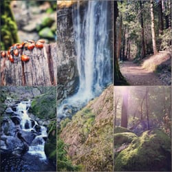
    Feather Falls Trail - Collage of sights along the trail

    Feather Falls Trail

    4.6(55 reviews)
    30.7 mi

    This hike was a blessing and a curse combined; stunningly beautiful views and an amazing waterfall…read moremixed with treacherous inclines, a mass amount of poison oak, and very aggressive bugs. I hiked this trail with my group in early June, and needless to say, this was one of the most beautiful and also one of the most challenging hikes that I've done. The entire loop measures about 8 miles, but you should add another mile if you plan to hike to the top of the falls. We started on the Upper Trail which is about 4.5 miles long. We took this trail to the top of the falls, then to the falls Overlook, and then to the Lower Falls trail which looped us back to the beginning of the trailhead. But be forewarned; if you take the Lower Falls trail back, the hike is very strenuous and not very well maintained. Right from the gate, you can see that this trail was filled with tons and tons of poison oak. If you don't know what poison oak looks like, you should look it up before you decide to come here. It's a beautiful plant, but you definitely don't want it touching you. And trust me, it's everywhere. All over the trails! I would recommend that you wear long pants and sleeves, especially if you're allergic. Also, there are tons of bugs! Lots of mosquitos and even ticks. Spray yourself with bug spray before you hit the trail. We sprayed and we still got bitten up pretty badly. Luckily, I didn't find any ticks on myself though. We also spotted a rattlesnake on the trail and you should also note that there have been bear sightings in the past. Just be aware of your surroundings. Okay, so now that I've gotten the scary stuff out of the way, let's focus on the actual hike. The hike through the Upper Trail is really pretty! It starts out flat and inclines gradually. It's full of greenery and mostly shaded. You'll pass over a small bridge that overlooks a baby waterfall that flows into a beautiful creek. There are ferns and flowers all throughout the trail. You'll see giant ants crawling on the ground. You'll also get a wonderful view of Bald Rock Dome which looks likes a mini Half Dome (Yosemite), and a sweeping view of the Middle Fork Feather River. The Overlook point to Feather Falls will be down some stairs and to the left. There are signs that will help to guide you. The view of Feather Falls is just simply breathtaking! The images are stunning but even they can't do it justice. You will truly have to just experience it for yourself. If you're up for some fun, I would highly recommend hiking to the top of the falls. It's seriously unbelievable up there. Storybook views, crystal clear water, and vivid greenery. It'll make you feel like you just walked into an enchanted forest. Like, is this really real? On the way back from the falls, we took the Lower Falls Trail back. This trail is a mile shorter than the Upper Falls Trail, but 10 times more strenuous. If you're looking for a less strenuous hike, either take the Lower to Upper Trail Loop or take the Upper Falls Trail there and back. Otherwise, you'll be in for a steep climb. Not only is this trail all uphill until the very end, it's also not well maintained. It's super rocky with lots of trees blocking the trail that you'll have to climb under and over. Parts of the trail are narrow and slippery. You should also make sure that you bring waaay more water than you think that you'll need because you WILL need it. After 9 miles of hiking, we were tired but felt extremely accomplished. The restrooms aren't the cleanest and the parking lot is pretty small, so I'd advise that you get there early. Would I do this hike again? Definitely! I would just take a different route and bring a stronger bug repellent. In the end, this hike is worth it for the views of one of the tallest waterfalls in California.

    First off, if you cannot have the decency to carry out your trash, don't hike…read more People leave trash EVERYWHERE on this trail. Literally, the most trash I've ever seen on a trail. People were leaving trash within hours of places we passed earlier. Unbelievable. Snack wrapper, water bottles and I even saw a dirty diaper. WTF?! Falls are awesome. Totally blew passed the turn for the loop on the way down so it was more of an out and back for us. Approximately 3.41 miles to the falls. Didn't have a problem with bugs but bring bug spray.

    Photos
    Feather Falls Trail
    Feather Falls Trail - You can watch our hike to Feather Fall YouTube video here - Go to link: https://youtu.be/LPyNEkOa6Wo

    You can watch our hike to Feather Fall YouTube video here - Go to link: https://youtu.be/LPyNEkOa6Wo

    Feather Falls Trail

    See all

    Sierra Buttes - Beautiful weather.

    Sierra Buttes

    4.8(17 reviews)
    27.0 mi

    .....I definitely underestimated the hike, lol…read more The hike to the fire lookout is about 2.5 miles one way, BUT the incline throughout most of the trail makes the hike a bit of a calves-burner. I'm not a seasoned hiker and I had to take multiple breaks, so much that I took like a 2 min break at each switcheroo point on the switchbacks right before the fire lookout lol (yeah there's even a set of unfriendly switchbacks here on top of the steady incline, hooray). Took me about 2 hours to arrive at the lookout lol but man oh man are the views gorgeous up there. I went on a windy day and I still felt safe climbing the stairs up to the actual lookout; the whole structure is pretty sturdy. Overall I would classify this hike as moderate-hard for people who don't hike often. Wouldn't say that this hike is very dangerous; just wear good shoes as there is a lot of loose gravel on the switchbacks and a couple of times I slipped when going back down towards the parking area. Would I ever do this hike again? Eh, to be honest probably not lol not because the hike itself but because of the long winding highway getting here. Very pretty trees throughout the 49 highway especially during autumn, but 1.5+ hours of driving on this highway (drove through Auburn) was a little too much for me. I definitely don't regret doing this whole adventure though. Google Maps "Sierra Buttes Trailhead" and the directions shown will lead you straight to the parking area/hiking trail entrance.

    This hike is unreal. I went 10/13/19. Weather was really…read morewarm. Definitely was comfortable in a short sleeve. I had my dog with me and we were off! It wasn't too crowded. I probably saw 20 people throughout the whole hike. Almost all had dogs so it was very dog friendly! Many had dogs off leash so be prepared for that. I've seen some bad reviews online about mountain bikers but I didn't see very many and the ones I did were really polite and moved right out of the way. Towards the top it got chilly and very windy so make sure to bring some layers if you plan on going up. There are stairs that are extremely steep at the end, but honestly If you don't go up them then there's no real reason to do this hike. The stairs are necessary. My dog was too scared to go up them so I did have to carry him. Once at the top, the views are BREATHTAKING. So incredibly beautiful. Definitely worth the steep incline and quad burning it takes to get there. Whole hike took me about 3 or 4 hours. It was amazing and I highly recommend. I would rate it as hard however, due to the steep incline and loose gravel. You definitely need to be careful and wear good shoes. I fell twice on my way down and that was not fun.

    Photos
    Sierra Buttes - The last few steps over some rocks

    The last few steps over some rocks

    Sierra Buttes - Ollie ready for his hike

    Ollie ready for his hike

    Sierra Buttes - Ollie tired at the top

    See all

    Ollie tired at the top

    Coburn Trail - hiking - Updated July 2026

    Loading...
    Loading...
    Loading...