
Deer Trap Trailhead Photos


More like Deer Trap Trailhead
Recommended Reviews - Deer Trap Trailhead
Start your review...

2 years ago
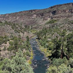
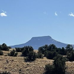
Just 5 miles from the heart of Los Alamos, after a short drive through a quiet residential neighborhood, we find this great little spot on Deer Trap Mesa to observe a beautiful view for miles in every direction. If you're up for a hike, there's a trail out to 2 different overlooks, your choice of 1.6 or 3ish miles total. But if the sun is already sinking low, it's a very short walk out past the historical markers to plenty of open space with dramatic vistas for your contemplation or photography. We arrived just in time for fall sunset and the pastel colors in the eastern sky (yes, the opposite of the sun) were breathtaking. My phone's camera really didn't do them justice, but I tried. I'd love to come back on another day with more time to check out the whole trail and see the ancient pit in the rock that gives the mesa its name. Ancient indigenous hunters would chase a deer down the path and into the hole for a quick finish. There are also a couple of staircases and few boulders to scramble if that's your thing. Wildlife watching is an option, too, from raptors soaring the currents overhead and the muledeer that still live in the area. read more

More info about Deer Trap Trailhead
1375 Barranca Rd
Los Alamos, NM 87544
Directions
Hours
Outdoor Amenities


Deer Trap Trailhead - hiking - Updated July 2026
Best of Los Alamos
People found Deer Trap Trailhead by searching for…
Things to Do in Los Alamos, NM
Hiking Trails in Los Alamos, NM
Beautiful Views in Los Alamos, NM
Watch Sunset in Los Alamos, NM
Walking Trails in Los Alamos, NM
Running Trails in Los Alamos, NM
Scenic Overlook in Los Alamos, NM
Parks BBQ Grills in Los Alamos, NM
Things to Do at Night in Los Alamos, NM
Kids Birthday Party Venues in Los Alamos, NM
Off Road Trails in Los Alamos, NM
Fun Things to Do With Kids in Los Alamos, NM
Places to Take Pictures in Los Alamos, NM
Dog Parks Off Leash in Los Alamos, NM
Trending Searches in Los Alamos, NM
Day Trips near Deer Trap Trailhead
Fruit Picking near Deer Trap Trailhead
Kayak Rental near Deer Trap Trailhead
Off Road Trails near Deer Trap Trailhead
Outdoor Activities near Deer Trap Trailhead
Picnic Spots near Deer Trap Trailhead
Places To Swim near Deer Trap Trailhead
Public Shower near Deer Trap Trailhead
Public Swimming Pools near Deer Trap Trailhead
River Swimming near Deer Trap Trailhead
River Tubing near Deer Trap Trailhead
Scenic Night View near Deer Trap Trailhead
Scenic Overlook near Deer Trap Trailhead
Sunrise View near Deer Trap Trailhead
Swimming Holes near Deer Trap Trailhead
Swimming Lakes near Deer Trap Trailhead
U Pick Farms near Deer Trap Trailhead
Watch Sunset near Deer Trap Trailhead
Browse Articles
Browse Nearby
Browse Brands
Related Searches in Los Alamos, NM
Affordable Kayak Rental Services in Los Alamos, New Mexico
Best Dog Hiking Trails Around Los Alamos, New Mexico
Best Fishing Locations and Guides in Los Alamos, New Mexico
Best Off Leash Dog Parks in Los Alamos, New Mexico
Best Places for Horseback Riding in Los Alamos, New Mexico
Best Places for Stunning Views in Los Alamos, New Mexico
Check Out Off Road Trails in Los Alamos, New Mexico
Discover Dog Friendly Trails to Explore in Los Alamos, New Mexico
Discover a Hiking Trail in Los Alamos, New Mexico
Discover the Best Night Hike Trails in Los Alamos, New Mexico
Dog-Friendly Hikes With Dogs in Los Alamos, New Mexico
Enjoy Camping Adventures Around Los Alamos, New Mexico
Enjoy Kayaking Adventures in Los Alamos, New Mexico
Enjoy Off Leash Dog Hikes in Los Alamos, New Mexico
Enjoy Tent Camping Spots Around Los Alamos, New Mexico
Enjoy the Best Picnic Spots and Ideas in Los Alamos, New Mexico
Enjoy the Best Walking Trails in Los Alamos, New Mexico
Experience Stunning Sunset Views in Los Alamos, New Mexico
Experience Thrilling White Water Rafting in Los Alamos, New Mexico
Explore Beautiful Parks and Green Spaces in Los Alamos, New Mexico
Explore Easy Hikes Perfect for All in Los Alamos, New Mexico
Explore Fun Activities to Do in Los Alamos, New Mexico
Explore Popular Campgrounds Near Los Alamos, New Mexico
Explore Secret Spots Worth Visiting in Los Alamos, New Mexico
Explore Top Dog Parks in Los Alamos, New Mexico Near You
Explore the Best Swimming Holes Around Los Alamos, New Mexico
Family Friendly Hiking With Kids in Los Alamos, New Mexico
Find Beautiful Views in Los Alamos, New Mexico
Find Top Dog Friendly Parks to Visit in Los Alamos, New Mexico
Find Top-Rated Waterfalls in Los Alamos, New Mexico Now
Find the Best Parks BBQ Grills in Los Alamos, New Mexico
Find the Best Parks for Picnics in Los Alamos, New Mexico
Find the Best Playgrounds to Visit in Los Alamos, New Mexico
Find the Best Scenic View Locations in Los Alamos, New Mexico
Hiking Trails With Waterfalls in Los Alamos, New Mexico
Off Leash Dog Hiking Trails in Los Alamos, New Mexico
Perfect Spots to Watch Sunset in Los Alamos, New Mexico
Plan a Scenic Drive Route Near Los Alamos, New Mexico
Popular Fishing Spots to Explore in Los Alamos, New Mexico
Popular Outdoor Activities to Try in Los Alamos, New Mexico
Popular Picnic Spots to Visit in Los Alamos, New Mexico
Safe River Swimming Areas in Los Alamos, New Mexico
Safe and Fun Parks for Kids in Los Alamos, New Mexico
Top Hiking Trails to Explore in Los Alamos, New Mexico
Top Playgrounds for Kids to Enjoy in Los Alamos, New Mexico
Top Running Trails to Explore in Los Alamos, New Mexico
Top Swimming Lakes to Enjoy in Los Alamos, New Mexico
Top Swimming Spots and Pools in Los Alamos, New Mexico
People who viewed Deer Trap Trailhead also viewed
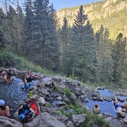
San Antonio Hot Springs
16 reviews
Las Conchas Trailhead
1 review
Ashley Pond Park
1 review
Virgin Mesa Trail
1 review
Northern Rio Grande National Heritage Center
1 review
East Park Dog Zone
1 review
Known World Guide Service
2 reviews
Ponderosa Christian Camp
1 review
Bodhi Manda Zen Center
3 reviews
Hummingbird Music Camp
4 reviews