Door Bluff Headlands County Park Photos


More like Door Bluff Headlands County Park
Recommended Reviews - Door Bluff Headlands County Park
Start your review...

Reviews With Photos

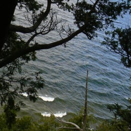
We stopped here on a whim on our way back from spending some time in Ellison Bay. We were pleasantly surprised and it seems like a hidden gem! There is a scenic view overlooking Lake MI. There is a staircase leading down to a walk way over the water. The sun was right above so it could make for a good spot to watch the sun go down too.

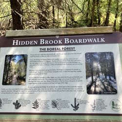
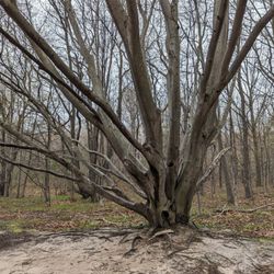
Door Bluff Headlands was an unexpected find during my visit to Door County. It's off the beaten path, with just a small turnaround/parking area, a portable toilet and some trails. The trails take you along the bluffs overlooking the water, and meander inland. There isn't signage and I'll admit that I ended up taking a bit longer of a hike that I planned on because I lost track of where I was. Because of it's location and amenities, you're not likely to encounter a lot of other people on your hike (but the ones I did were friendly). There was some fog on the day I visited, which gave the trail and view of the lake a mysterious air, and I joked that it looked like I'd found the edge of the map as the view just disappeared a short way out into the water. Per a handwritten sign on one of the trees, the park is also home to the highest point in Door County! read more


Definitely off the beaten path. The signs to get there are sparse. Rough trail leads to a spectacular overview over Green Bay. Two porta potties in the parking area. No signage. Moderately rough trail. There is a catwalk they projects out. read more

We stopped here on a whim on our way back from spending some time in Ellison Bay. We were pleasantly surprised and it seems like a hidden gem! There is a scenic view overlooking Lake MI. There is a staircase leading down to a walk way over the water. The sun was right above so it could make for a good spot to watch the sun go down too. read more

6 years ago
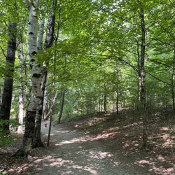
A beautiful place for a quiet walk. Not too challenging of a hike, just have to watch your step on tree roots. The view is spectacular. Not a great place to get to the water if that's what you're looking for. This is one of my favorite places, especially in the fall read more


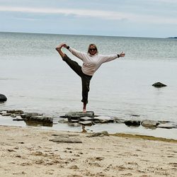
Out of the beaten path but worth it. Coming from the South, turn on the first left street after the tourist information hut in Ellison Bay. Natural trails who will take you on top of bluffs overlooking Lake Michigan.....you walk among the trees, take a quick peak between two branches, a longer one at the first clearing.....you can even look all the way down to the rocky beaches at some points, and spot a bonefire all set up for a fish boil?!? It's beautiful, not busy, free and unique. read more


7 years ago
10 years ago
More info about Door Bluff Headlands County Park
12900 Door Bluff Park Rd
Ellison Bay, WI 54210
Directions
Hours
Outdoor Amenities
Ask the Community - Door Bluff Headlands County Park


Why does Yelp recommend reviews?
1 review that is not currently recommended
The reviews below are not factored into the business's overall star rating.
10 years ago
Door Bluff Headlands County Park - hiking - Updated June 2026
Best of Ellison Bay
People found Door Bluff Headlands County Park by searching for…
Beaches in Ellison Bay, Wisconsin
Parks in Ellison Bay, Wisconsin
Things to Do in Ellison Bay, Wisconsin
Hiking Trails in Ellison Bay, Wisconsin
Fishing in Ellison Bay, Wisconsin
Fun Things to Do With Kids in Ellison Bay, Wisconsin
Fishing Spots in Ellison Bay, Wisconsin
Scenic View in Ellison Bay, Wisconsin
Walking Trails in Ellison Bay, Wisconsin
Scenic Overlook in Ellison Bay, Wisconsin
Secret Spots in Ellison Bay, Wisconsin
Sunset View in Ellison Bay, Wisconsin
Waterfalls in Ellison Bay, Wisconsin
View Points in Ellison Bay, Wisconsin
Swimming Lakes in Ellison Bay, Wisconsin
Natural Hot Springs in Ellison Bay, Wisconsin
Parks for Kids in Ellison Bay, Wisconsin
Fishing With Kids in Ellison Bay, Wisconsin
Running Trails in Ellison Bay, Wisconsin
Beautiful Views in Ellison Bay, Wisconsin
Lookout Points in Ellison Bay, Wisconsin
Fishing Lake in Ellison Bay, Wisconsin
Trending Searches in Ellison Bay, WI
Browse Articles
Browse Nearby
Browse Brands
Related Searches in Ellison Bay, WI
Affordable Kayak Rental Services in Ellison Bay, Wisconsin
Best Fishing Locations and Guides in Ellison Bay, Wisconsin
Best Places for Stunning Views in Ellison Bay, Wisconsin
Best Sledding Spots and Fun in Ellison Bay, Wisconsin
Best Spots for Star Gazing in Ellison Bay, Wisconsin
Discover Popular Bike Trails in Ellison Bay, Wisconsin
Discover Popular Photo Spots in Ellison Bay, Wisconsin
Discover Top Boat Tours in Ellison Bay, Wisconsin for All Ages
Discover Top Nature Parks to Visit in Ellison Bay, Wisconsin
Discover a Hiking Trail in Ellison Bay, Wisconsin
Discover the Best Night Hike Trails in Ellison Bay, Wisconsin
Enjoy Camping Adventures Around Ellison Bay, Wisconsin
Enjoy Kayaking Adventures in Ellison Bay, Wisconsin
Enjoy Scenic Night View Experiences in Ellison Bay, Wisconsin
Enjoy Tent Camping Spots Around Ellison Bay, Wisconsin
Enjoy the Best Picnic Spots and Ideas in Ellison Bay, Wisconsin
Enjoy the Best Walking Trails in Ellison Bay, Wisconsin
Experience Stunning Sunset Views in Ellison Bay, Wisconsin
Experience Thrilling White Water Rafting in Ellison Bay, Wisconsin
Explore Beautiful Parks and Green Spaces in Ellison Bay, Wisconsin
Explore Bike Rentals Throughout Ellison Bay, Wisconsin
Explore Easy Hikes Perfect for All in Ellison Bay, Wisconsin
Explore Free Things to Do Around Ellison Bay, Wisconsin
Explore Nature Spots Around Ellison Bay, Wisconsin
Explore Popular Boat Charters Near Ellison Bay, Wisconsin
Explore Popular Campgrounds Near Ellison Bay, Wisconsin
Explore Popular Scenic Overlook Points in Ellison Bay, Wisconsin
Explore Popular View Points Around Ellison Bay, Wisconsin
Explore Scenic Lakes to Visit in Ellison Bay, Wisconsin
Explore the Best Beach Spots in Ellison Bay, Wisconsin
Explore the Best Boating Spots in Ellison Bay, Wisconsin
Explore the Best Trail Options in Ellison Bay, Wisconsin
Explore the Scenic River in Ellison Bay, Wisconsin
Family Friendly Hiking With Kids in Ellison Bay, Wisconsin
Find Beautiful Views in Ellison Bay, Wisconsin
Find Fun Kids Activities Outdoor in Ellison Bay, Wisconsin
Find the Best Parks for Picnics in Ellison Bay, Wisconsin
Find the Best Scenic View Locations in Ellison Bay, Wisconsin
Picnic Areas With BBQ Pits Available in Ellison Bay, Wisconsin
Plan a Scenic Drive Route Near Ellison Bay, Wisconsin
Popular Picnic Spots to Visit in Ellison Bay, Wisconsin
Popular Places to Take Pictures in Ellison Bay, Wisconsin
Popular Things to Do in Ellison Bay, Wisconsin
Popular Things to See in Ellison Bay, Wisconsin
Safe River Swimming Areas in Ellison Bay, Wisconsin
Safe and Fun Parks for Kids in Ellison Bay, Wisconsin
Top Running Trails to Explore in Ellison Bay, Wisconsin
Top Swimming Lakes to Enjoy in Ellison Bay, Wisconsin