Goodan Ranch and Sycamore Canyon Open Space Photos


You might also consider
More like Goodan Ranch and Sycamore Canyon Open Space
Recommended Reviews - Goodan Ranch and Sycamore Canyon Open Space
Start your review...

Reviews With Photos

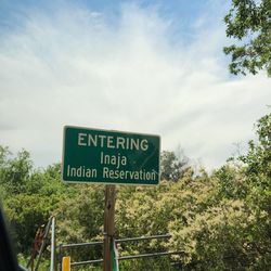
Family-friendly trails in North East County. My best advice would be to come here during the winter / spring months. The mild temperature and running streams definitely make this a fun little hike for the whole family. Perhaps the highlight of the afternoon was the tiny visitor center in the middle of Goodan Ranch. Note - In the parking lot there are three different trails. Be sure to take the "one-way" Martha's Grove Trail. Take this trail all the way until you reach the windmill. From there head right to the Visitor Center and Ranch. It's a total of 3.6 miles and after the first initial hill, it's pretty flat. Tips - The best time to hike these trails are after a rain. All of the little creeks are flowing with water and the kids will love trying to cross them. - Some rugged shoes are recommended, especially at the beginning of the trail. - There are two preserves here ( Sycamore Canyon and The Mission Trails Regional Park West Sycamore.) You can access both of the trails from this parking lot. Mission Trails is located in the rightmost corner of the parking lot. - Coyotes even during the day

Went on a hike down the ridge trail in the middle of the day and was concerned about taking that route back up as it was a long climb. However, reached the windmill at the bottom and discovered another path back up to the parking lot. Went up Cardiac Hill but it wasn't as bad as it sounds. I think the Ridge trail back up would have been harder. There was more shade too on Cardiac hill which was good. Creeks were dry and scenery was unimpressive. But the stillness and quiet were a nice break from the city.

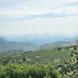
So many paths to try... today we did about a 6 mile hike loop and enjoyed an easy to early moderate hike. There are lots of areas with large gravel and mild slopes, but nothing overly strenuous. We went up something called Cardiac Hill, but it really wasn't so bad-- just a gradual but long upward slope. It was a good time of year to go-- it's starting to get warmer out in east county, but we kept pretty cool overall, and there were a few shady spots to stop and rest here and there. The area is beautiful yet a bit stark, typical of San Diego east county scenery- lots of chapparal, sun-bleached boulders, and a creek here and there. A fair amount of scat all about-- so you know the animals are out there, but we didn't see too many little friends today. It was pretty quiet out on the trails- we only ran into 2 other hiking pairs over about 3 hours from 9-noonish. I enjoyed being out here-- it was a quieter kind of hike. A good place to trek along with your thoughts and musings. Bring lots of water and treat yourself to some snacks along your route. Definitely wear comfortable hiking shoes, and expect to get a bit of grit in your shoes here and there.

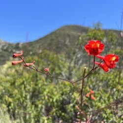
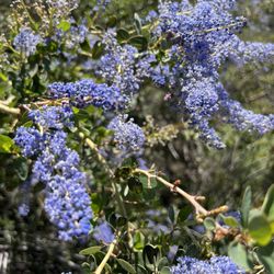
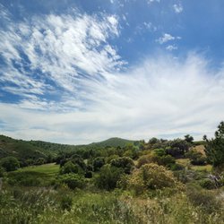
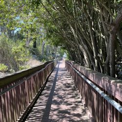
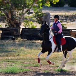
A few weeks ago my cousin and I were looking for a chill way to spend the day. Our plan was to look for a place without a lot of people, hike for a while... nothing too challenging, but to get some exercise. We also wanted to bring a picnic for after our hike. Goodan Ranch was suggested to us by a family member, as he does regular mountain biking there. Anyway, getting there was relatively easy. We spent a good deal of time on a small, but neatly paved road that lead a ways off a highway to a gravel lot. I know that they do stargazing and other events there, so I imagine the lot can get crowded, but that day, there was ample parking available. I liked that there were several signs mapping the trails around the area. There is a large loop, larger loop and a few ways to cut back for a shorter hikes. The paths are mostly open, providing space for bikers or horses. We only saw a couple bikers and a couple hikers during the time that we were there. I enjoyed the green pastures and variety of colorful wildflowers. It was really quite beautiful. There were a couple of picnic tables. When we had finished our hike, we grabbed our cooler from the car and we were able walk back down a short ways to the picnic table. Another plus is that the restrooms near the parking area were very clean. I look forward to heading back for a stargazing event! read more


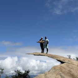
I was looking at hiking trails online and noticed this was a 6.5 mile loop on a preserve just south of Scripps Poway Parkway and west of Hwy 67. I entered the property on the northeast side off Hwy 67. It was a staging area set up for horses to be unloaded and taken on the trails. The path started off wide for equestrian riders and meandered up and down to the south and west before tailing off. After the descent, the trek followed very flat terrain and headed northbound to a ranger station which was in the middle of the ranch. On my way, there was a historic windmill which I somehow completely missed. I will have to notice that landmark next time and take a photo. I didn't make a stop inside the ranger station, but it was a nice sized building which had outdoor restroom facilities too. Continuing north for another mile or so brought you to the Goodan Ranch Staging Area. That was the main entrance to the Sycamore Canyon Open Space Preserve. A small lot was available for parking. To finish the loop back to where I started, a one-way trail (Martha's Grove) took me east, south and then west before a sharp switchback towards the east again led me up Cardiac Hill. This was the last segment before I arrived where my vehicle was parked on Sycamore Park Drive at the Hwy 67 Staging Area. Overall, this was an easy to moderate difficulty hike. There wasn't much shade until you were near the ranger station and then on the Martha's Grove Trail. I completed the entire circuit in 2.5 hours in beautiful mid-70 degree weather with low humidity. read more


6 months ago
Family-friendly trails in North East County. My best advice would be to come here during the winter / spring months. The mild temperature and running streams definitely make this a fun little hike for the whole family. Perhaps the highlight of the afternoon was the tiny visitor center in the middle of Goodan Ranch. Note - In the parking lot there are three different trails. Be sure to take the "one-way" Martha's Grove Trail. Take this trail all the way until you reach the windmill. From there head right to the Visitor Center and Ranch. It's a total of 3.6 miles and after the first initial hill, it's pretty flat. Tips - The best time to hike these trails are after a rain. All of the little creeks are flowing with water and the kids will love trying to cross them. - Some rugged shoes are recommended, especially at the beginning of the trail. - There are two preserves here ( Sycamore Canyon and The Mission Trails Regional Park West Sycamore.) You can access both of the trails from this parking lot. Mission Trails is located in the rightmost corner of the parking lot. - Coyotes even during the day read more


7 years ago
Went on a hike down the ridge trail in the middle of the day and was concerned about taking that route back up as it was a long climb. However, reached the windmill at the bottom and discovered another path back up to the parking lot. Went up Cardiac Hill but it wasn't as bad as it sounds. I think the Ridge trail back up would have been harder. There was more shade too on Cardiac hill which was good. Creeks were dry and scenery was unimpressive. But the stillness and quiet were a nice break from the city. read more

13 years ago
So many paths to try... today we did about a 6 mile hike loop and enjoyed an easy to early moderate hike. There are lots of areas with large gravel and mild slopes, but nothing overly strenuous. We went up something called Cardiac Hill, but it really wasn't so bad-- just a gradual but long upward slope. It was a good time of year to go-- it's starting to get warmer out in east county, but we kept pretty cool overall, and there were a few shady spots to stop and rest here and there. The area is beautiful yet a bit stark, typical of San Diego east county scenery- lots of chapparal, sun-bleached boulders, and a creek here and there. A fair amount of scat all about-- so you know the animals are out there, but we didn't see too many little friends today. It was pretty quiet out on the trails- we only ran into 2 other hiking pairs over about 3 hours from 9-noonish. I enjoyed being out here-- it was a quieter kind of hike. A good place to trek along with your thoughts and musings. Bring lots of water and treat yourself to some snacks along your route. Definitely wear comfortable hiking shoes, and expect to get a bit of grit in your shoes here and there. read more


13 years ago
Great intermediate hiking spot for kids while the weather is not so hot. My boys have been hiking here since the younger one was five. Word of caution: keep a savvy adult in front at all times for rattlesnake watch or ensure your kids are snake savvy (mine are) and focused on the trail, not on who's in front. read more


12 years ago
11 years ago
13 years ago
More info about Goodan Ranch and Sycamore Canyon Open Space
Poway, CA 92064
Directions
(858) 513-4737
Call Now
Visit Website
http://goodanranch.org
Hours
Outdoor Amenities
Ask the Community - Goodan Ranch and Sycamore Canyon Open Space
You might also consider


Goodan Ranch and Sycamore Canyon Open Space - hiking - Updated July 2026
Best of Poway
People found Goodan Ranch and Sycamore Canyon Open Space by searching for…
Star Gazing in Poway, California
Hiking Trails in Poway, California
Photo Spots in Poway, California
Off Road Trails in Poway, California
Meteor Shower in Poway, California
Watch Sunset in Poway, California
Stargazing in Poway, California
Dog Friendly Hiking Trails in Poway, California
Paved Walking Trails in Poway, California
Bike Paths in Poway, California
Hiking With Kids in Poway, California
Waterfall Hike in Poway, California
Fishing Spots in Poway, California
Places to Walk in Poway, California
Sunset View in Poway, California
Fun Things to Do at Night in Poway, California
Mountain Biking in Poway, California
Running Trails in Poway, California
Abandoned Buildings in Poway, California
Swimming Lakes in Poway, California
Tourist Attractions in Poway, California
Trending Searches in Poway, CA
Browse Articles
Browse Nearby
BEST of Poway, California Restaurants near Goodan Ranch and Sycamore Canyon Open Space
BEST of Poway, California Coffee near Goodan Ranch and Sycamore Canyon Open Space
BEST of Poway, California Breakfast near Goodan Ranch and Sycamore Canyon Open Space
BEST of Poway, California Wineries near Goodan Ranch and Sycamore Canyon Open Space
BEST of Poway, California Shopping near Goodan Ranch and Sycamore Canyon Open Space
BEST of Poway, California Campgrounds near Goodan Ranch and Sycamore Canyon Open Space
BEST of Poway, California Thrift Stores near Goodan Ranch and Sycamore Canyon Open Space
Browse Brands
Related Searches in Poway, CA
Affordable Kayak Rental Services in Poway, California
Best Fishing Locations and Guides in Poway, California
Best Places for Horseback Riding in Poway, California
Best Waterfalls and Swimming Holes in Poway, California
Check Out Off Road Trails in Poway, California
Discover Dog Friendly Trails to Explore in Poway, California
Discover Scenic Mountain Bike Trails Near Poway, California
Discover Walking Parks in Poway, California Near You
Discover a Hiking Trail in Poway, California
Discover the Best Night Hike Trails in Poway, California
Discover the Best Running Track in Poway, California
Dog-Friendly Hikes With Dogs in Poway, California
Enjoy Camping Adventures Around Poway, California
Enjoy Exciting Mountain Biking Adventures in Poway, California
Enjoy Kayaking Adventures in Poway, California
Enjoy Tent Camping Spots Around Poway, California
Enjoy a Beautiful Waterfall Hike in Poway, California
Enjoy a Peaceful Nature Walk in Poway, California
Enjoy the Best Picnic Spots and Ideas in Poway, California
Enjoy the Best Walking Path in Poway, California
Enjoy the Best Walking Trails in Poway, California
Exciting Cliff Jumping Spots in Poway, California
Explore Beautiful Parks and Green Spaces in Poway, California
Explore Easy Hikes Perfect for All in Poway, California
Explore Fun Activities to Do in Poway, California
Explore Popular Campgrounds Near Poway, California
Explore the Best Beach Spots in Poway, California
Explore the Best Trail Options in Poway, California
Family Friendly Hiking With Kids in Poway, California
Find Beautiful Views in Poway, California
Find Popular Ziplining Spots Around Poway, California
Find the Best Parks for Picnics in Poway, California
Find the Best Scenic View Locations in Poway, California
Great Places to Walk in Poway, California
Hike the Popular Waterfall Trail in Poway, California
Hiking Trails With Waterfalls in Poway, California
Off Leash Dog Hiking Trails in Poway, California
Plan a Scenic Drive Route Near Poway, California
Popular Outdoor Activities to Try in Poway, California
Popular Picnic Spots to Visit in Poway, California
Safe River Swimming Areas in Poway, California
Safe and Fun Parks for Kids in Poway, California
Top Climbing Spots and Gyms in Poway, California
Top Paddleboarding Activities in Poway, California
Top Places for Snorkeling in Poway, California
Top Running Trails to Explore in Poway, California
Top Swimming Lakes to Enjoy in Poway, California
Top Swimming Spots and Pools in Poway, California
People who viewed Goodan Ranch and Sycamore Canyon Open Space also viewed
Blue Sky Ecological Reserve
67 reviews
Black Mountain Open Space Park
56 reviews
Mira Mesa, Torrey Hills
Cleveland National Forest
35 reviews
Chimney Rock Open Space Preserve
1 review
Iron Mountain
510 reviews
Big Laguna Trail
3 reviews
Mount Woodson Trail
834 reviews
Ellie Lane Trail
7 reviews
Rose Canyon Bicycle Path
10 reviews
South Poway Trailhead and Equestrian Staging Area
2 reviews