Black Mountain Open Space Park Photos


You might also consider
More like Black Mountain Open Space Park
Recommended Reviews - Black Mountain Open Space Park
Start your review...

Reviews With Photos

This review is for the Nighthawk Trail to Black Mountain Summit which was a little bit over 4 miles round trip that took ~2 hours. Ton of inclines and extremely rocky trail. Definitely want to wear proper hiking shoes. Plenty of nice views as you get closer to the summit. Free parking at the Hilltop Community Park.
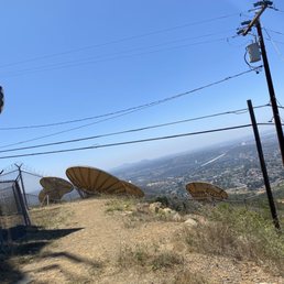
Started July 2020 with a kick-butt hike ! So glad I finally checked this place out since it's in my neck of the woods ! Thanks to my bro for accompanying me! Tons of parking at Hilltop park and along the street on a weekday and it wasn't crowded at all. I found this hike more challenging than Cowles mountain due to the steep, rocky, uphill climbs until you reach the summit. Heading back is faster and mostly downhill, but be careful due to the rocks on the trails. Trail entrance is easy to find at Hilltop park. Restrooms are available at the park, but not along the trails so take advantage now. We chose to hike the 'Nighthawk Trail' up to the summit and took ~2.5 miles out and back. There was hardly any shade so prepare with sunscreen and a hat. I'm not an expert hiker so the inclines were challenging, but doable. It's worth it when you reach the top! The trails were well kept and spacious, but do expect tons of rocks and gravel so be careful not to twist your ankle. Recommend investing in good hiking boots with proper tread and stay hydrated, especially summer time. The summit at the top is beautiful. We had to take some pictures and enjoy the views of my hometown! The communication satellites made you feel like you're in space. Perhaps Mars ? ET phone home. Overall, I had a quick and decent workout and so glad it's super close to home! I'd like to return and checkout the other trails in the area. So many hidden gems ! Love it !


First time hiking up any mountain, I probably should have taken it slow and kept hydrated. I did neither yet it wasn't too bad. The Glider trail is only about 10 minutes or so. I just stopped once to take off my hoodie && catch my breath. Hiking boots are not necessary, my running shoes did the job. It was a beautiful view at the top, we relaxed there for a bit and took pictures. I would definitely recommend coming here if you want the scenery without doing too much work. Be careful coming down it can be slippery. I know I did a couple of snowboarding moves coming down!!

My new favorite hike! 1) because it's so close by, and 2) it's not crowded. I saw about two mountain bikers and three other hikers along the trail briefly. I've been wanting to check this hike off my San Diego trail list, and finally had the opportunity to do so on a Tuesday morning. Trail entrance is easy to get to from Hilltop Park. There is plenty of parking at the park and restrooms if needed as well. My cousin and I started this hike around 8am with slightly overcast weather. The nighthawk trail and miners loop took about 2.5hrs to complete including our snack break time at the summit. Total distance was just over 6 miles. Pretty easy-moderate hike with several inclines to get you heart rate up. AllTrails app reviews stated some parts of the trail are closed. So we opted to go counter-clockwise to the Black Mountain summit and then complete the Miners loops on our way back down the same trail versus doing the other side of the Nighthawk loop. The trail is well maintained, however quite rocky! I recommend actual hiking boots with comfortable hard soles versus running shoes. The weather wasn't too hot, so a 32oz water bottle was more than enough. I could definitely feel the heat coming back down, so maybe bring more if you go later in the day or with hotter weather. Perfect local hike to work off those recent holiday eating calories.
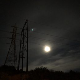
First time hiking this trail was for the blood wolf moon. We started a bit past 7pm after a week of rain I wasn't sure how the trail would be. It's not a difficult hike, I do feel it was more challenging doing it at night. It's quite rocky on some parts with an incline and decline. There were plenty of flat parts you can easily run through. Trekking poles aren't necessary but helpful navigating down the rocky decline areas. It's pretty short if you take the trail straight up to the top where the radio towers are. Great views of the city lights if you do it at night. It's a wide trail, felt more like a service road than anything. It was a cold night so I layered up but broke sweat getting up there in all those layers. Looking forward to trying this full trail out again during the daytime to get a real feel for the trail. Overall I enjoyed this trail, not difficult but you get a little workout.

Located in Rancho Penasquitos, Black Mountain Open Space Park is exactly what it sounds like. It's an open space park in the Black Mountain area. The "park" is covered with rolling hills, some wildlife, sage, canyons, and trails. The center of the peak is about 1500 ft in elevation and has a beautiful view of the city. There are different trailheads, and this information was found from the City San Diego website: ------------------------------- How to Get to Black Mountain Black Mountain Open Space Park is easily accessible from four different trailheads. Black Mountain itself is served by two trailheads. From I-15 or I-5, you can take Hwy. 56 to Black Mountain Road and head north. For the Nighthawk Trailhead, turn right on Oviedo Street and right again on Oviedo Way. Proceed to the top of the hill and park at Hilltop Community Park. The trailhead is just to the north. If you would like to get to the Miner's Ridge Loop Trailhead, continue north on Black Mountain Road until you reach Carmel Valley Road. Turn Right (east) on Carmel Valley Road and proceed approximately .75 miles to the entrance you will see on your right. The northwest portion of the park also has two trailheads. The first is on the north end of Black Mountain Ranch Community Park. From the intersection of Black Mountain Road and Carmel Valley Road described above, turn right (east) and take your first left at the stoplight into the community park. To reach the San Dieguito Trailhead from the same location, you will turn left (west) on Carmel Valley Road and proceed to Camino Del Sur. Take a right (north) at the stoplight and continue on Camino Del Sur. When you reach San Dieguito Road, make a left turn (west) and the trailhead is .5 miles on your right. --------------------------------- I took the Carmel Valley Road emtrance and parked at the Black Mountain Community Park lot. It is a bit rocky getting to the parking lot and there is no marked spaces as it is a dirt area , but park accordingly and respectfully. See map that I posted as a picture below for some trail names. I wanted to try out an easy trail on a Sunday morning to give me the best views. The trail I tried was , when facing the mountain, to your left. I took a left and continued straight on. The city line was besides me the whole time I was walking and gave me a beautiful view. It was an easy hike with some rocky areas and terrain, but very little elevation, and when it did go up..it was very casual. It was also nicely groomed and well maintained. The view was the best part! There is so much to explore here, so I will be back!

Black mountain open space park is a wide range of hills and mountains for hiking and biking. Black Mountain itself can be reached by two trails. Entrance/parking: 1.The Nighthawk Trailhead starts at the Hilltop Community Park. There are plenty of parking. 2. Miner's Ridge Loop Trailhead on Carmel Valley Road Trail distance/difficulty: The distance to summit is about 5 miles round-trip. It is a fairly easy hike with mild to moderate slopes and well maintained trails. When I heard "Black Mountain", I was imagining high peaks and deep forests area. However, it wasn't exactly as I pictured. There were little shading along the way and the trails were mostly mild slopes. It is very easy to get to the summit. I was hoping to see breath-taking view when I reached the summit. However, the summit is occupied by a satellite station. It was quite disappointed that the view wasn't as good as I expected. Overall, it was an easy hike and still provided good exercise and off the city feeling.

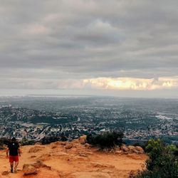
The best part about this hike is the spectacular views. The Sky was especially beautiful today, what with the puffy clouds interspersed in the blue sky. Flowers were blooming too. The hike itself was fine, though not really my favorite. The trail was really rocky, so I had to pay really close attention in order not to twist my ankle (and on the way down I actually slipped a couple of times, but didn't fall). I feel like I only got to look at the beautiful views sometimes, as a result. The hike is steep on the way up, but you're trying to get to a summit, so that isn't that surprising. As you get close to the top you see these rusted satellite dishes, which are ok, but I wish they hadn't been there Other than that, the hike was fine. It's nice to be able to hike up a mountain in the middle of the city.

I haven't been hiking mountains for some months now, so I wanted an easy way to go to the top in the monthly 'full moon hiking' a German friend regularly organizes. I am glad she opted to trailhead at the Hilltop Community Park, the named 'Nighthawk' trail. Very cool to see the shadow of all hikers participating in that excursion because the moonlight was very intense! I almost need moonglasses:). It was an easy hike (I think roundtrip was around 5 miles) but I have to recommend to bring sturdy shoes or real hiking boots. I brought mine, but they are kind of old, so with so many rocks I almost fell a couple of times. Too many loose rocks for my taste, I prefer flat terrain, but nature is nature. I am glad that I carried a lamp with me so I could check where I was putting my step all the time (even if the night was bright, not enough for those rocks!). The views from the top are nice, very panoramic, but if you don't like to see suburbian houses from a moutain, then go to a more wild location. This was actually my first time at the Black Montain and I liked the proximity from where I live, the fact that was not difficult hike and we could go in a group with different levels and the picnic and dancing once on the top made a magical night.

We approached the park from a different trailhead today, the San Dieguito Trailhead which is very close to Rancho Santa Fe. The hike was closer to 4 miles or so, some great plants, awesome vistas and a couple brutal climbs. We saw some beautiful flowers, and the conditions were amazing. The recent rain gave the normally hardpacked sandy/clay soil a sponge like feel and was truly refreshing to walk on. This is a really fun and serene hike, but a bit more challenging than the Miner's Loop trailhead. Bring water, always bring water!!!


Went here on Tuesday evening to see the full moon in a pink hue. The nighthawk trail has one of the greatest view in town. I've been living in San Diego close to nine years and I'm suprised this was my first time hiking this trail. Beautiful in the day and night time. I recommend this trail for all-levels.

I've been coming here for years. Tons of open space that's well maintained. With beautiful views of the established and up and coming neighborhoods, it's worth the trek. A good amount of parking and trails that allow you to get your cardio on. Everything I visit, there is always a photo session taking place. I'll be back soon. read more


The Yelp address is incorrect for this listing as it should be where Hilltop Community Park is located in Rancho Penasquitos. You can use their parking lot if space is available, or you can park curbside on Oviedo Way. There was a large marker at the trailhead which provided a map of Black Mountain Open Space Park. I came to trek Black Mountain including the Nighthawk Trail and the Miner's Ridge Loop. The latter appeared to be closed, but I walked it anyway and came across several runners who were jogging along the path. The ascent to the summit was a decent challenge that I would rate as moderate. The descent was when I tried Miner's Ridge Loop instead of going back down the way I came up. The Loop was narrower and windier, but it felt more like a wilderness hike which I enjoyed better. It also added approximately 1.25 miles to the round trip. If you want a shorter up and down hike, then just go to the peak and back. If you want additional length and more challenge, then include the Loop as part of your journey. read more


Boyfriend and I did the nighthawk trail up to black mountain where the satellite towers are. I would say this hike is a little over 4 miles round trip and difficulty level is moderate. The way up is steep but not terrible, it's like a slight incline the whole 3/4 ish way up. Wear actual hiking boots because it's very very rocky! I wore running shoes and slipped on the rocks at one point and scratched my knee a bit lol. Very scenic views, no shade and we went on a Saturday but there weren't many people doing the hike. A lot of people brought their dogs on leashes, very cute. It's a very clean trail! No dog poop or trash. I would do it Again but not during the summer or warmer months as there is no shading. Would recommend! read more


This review is for the Nighthawk Trail to Black Mountain Summit which was a little bit over 4 miles round trip that took ~2 hours. Ton of inclines and extremely rocky trail. Definitely want to wear proper hiking shoes. Plenty of nice views as you get closer to the summit. Free parking at the Hilltop Community Park. read more


Started July 2020 with a kick-butt hike ! So glad I finally checked this place out since it's in my neck of the woods ! Thanks to my bro for accompanying me! Tons of parking at Hilltop park and along the street on a weekday and it wasn't crowded at all. I found this hike more challenging than Cowles mountain due to the steep, rocky, uphill climbs until you reach the summit. Heading back is faster and mostly downhill, but be careful due to the rocks on the trails. Trail entrance is easy to find at Hilltop park. Restrooms are available at the park, but not along the trails so take advantage now. We chose to hike the 'Nighthawk Trail' up to the summit and took ~2.5 miles out and back. There was hardly any shade so prepare with sunscreen and a hat. I'm not an expert hiker so the inclines were challenging, but doable. It's worth it when you reach the top! The trails were well kept and spacious, but do expect tons of rocks and gravel so be careful not to twist your ankle. Recommend investing in good hiking boots with proper tread and stay hydrated, especially summer time. The summit at the top is beautiful. We had to take some pictures and enjoy the views of my hometown! The communication satellites made you feel like you're in space. Perhaps Mars ? ET phone home. Overall, I had a quick and decent workout and so glad it's super close to home! I'd like to return and checkout the other trails in the area. So many hidden gems ! Love it ! read more


3 years ago
This is a moderate difficulty to easy hike. Hardly anyone on the trail the day we went. We occasionally saw a couple of horses running on the rail. Very green this February with all the rain. read more


5 years ago
7 years ago
First time hiking up any mountain, I probably should have taken it slow and kept hydrated. I did neither yet it wasn't too bad. The Glider trail is only about 10 minutes or so. I just stopped once to take off my hoodie && catch my breath. Hiking boots are not necessary, my running shoes did the job. It was a beautiful view at the top, we relaxed there for a bit and took pictures. I would definitely recommend coming here if you want the scenery without doing too much work. Be careful coming down it can be slippery. I know I did a couple of snowboarding moves coming down!! read more


4 years ago
My new favorite hike! 1) because it's so close by, and 2) it's not crowded. I saw about two mountain bikers and three other hikers along the trail briefly. I've been wanting to check this hike off my San Diego trail list, and finally had the opportunity to do so on a Tuesday morning. Trail entrance is easy to get to from Hilltop Park. There is plenty of parking at the park and restrooms if needed as well. My cousin and I started this hike around 8am with slightly overcast weather. The nighthawk trail and miners loop took about 2.5hrs to complete including our snack break time at the summit. Total distance was just over 6 miles. Pretty easy-moderate hike with several inclines to get you heart rate up. AllTrails app reviews stated some parts of the trail are closed. So we opted to go counter-clockwise to the Black Mountain summit and then complete the Miners loops on our way back down the same trail versus doing the other side of the Nighthawk loop. The trail is well maintained, however quite rocky! I recommend actual hiking boots with comfortable hard soles versus running shoes. The weather wasn't too hot, so a 32oz water bottle was more than enough. I could definitely feel the heat coming back down, so maybe bring more if you go later in the day or with hotter weather. Perfect local hike to work off those recent holiday eating calories. read more


First time hiking this trail was for the blood wolf moon. We started a bit past 7pm after a week of rain I wasn't sure how the trail would be. It's not a difficult hike, I do feel it was more challenging doing it at night. It's quite rocky on some parts with an incline and decline. There were plenty of flat parts you can easily run through. Trekking poles aren't necessary but helpful navigating down the rocky decline areas. It's pretty short if you take the trail straight up to the top where the radio towers are. Great views of the city lights if you do it at night. It's a wide trail, felt more like a service road than anything. It was a cold night so I layered up but broke sweat getting up there in all those layers. Looking forward to trying this full trail out again during the daytime to get a real feel for the trail. Overall I enjoyed this trail, not difficult but you get a little workout. read more


Located in Rancho Penasquitos, Black Mountain Open Space Park is exactly what it sounds like. It's an open space park in the Black Mountain area. The "park" is covered with rolling hills, some wildlife, sage, canyons, and trails. The center of the peak is about 1500 ft in elevation and has a beautiful view of the city. There are different trailheads, and this information was found from the City San Diego website: ------------------------------- How to Get to Black Mountain Black Mountain Open Space Park is easily accessible from four different trailheads. Black Mountain itself is served by two trailheads. From I-15 or I-5, you can take Hwy. 56 to Black Mountain Road and head north. For the Nighthawk Trailhead, turn right on Oviedo Street and right again on Oviedo Way. Proceed to the top of the hill and park at Hilltop Community Park. The trailhead is just to the north. If you would like to get to the Miner's Ridge Loop Trailhead, continue north on Black Mountain Road until you reach Carmel Valley Road. Turn Right (east) on Carmel Valley Road and proceed approximately .75 miles to the entrance you will see on your right. The northwest portion of the park also has two trailheads. The first is on the north end of Black Mountain Ranch Community Park. From the intersection of Black Mountain Road and Carmel Valley Road described above, turn right (east) and take your first left at the stoplight into the community park. To reach the San Dieguito Trailhead from the same location, you will turn left (west) on Carmel Valley Road and proceed to Camino Del Sur. Take a right (north) at the stoplight and continue on Camino Del Sur. When you reach San Dieguito Road, make a left turn (west) and the trailhead is .5 miles on your right. --------------------------------- I took the Carmel Valley Road emtrance and parked at the Black Mountain Community Park lot. It is a bit rocky getting to the parking lot and there is no marked spaces as it is a dirt area , but park accordingly and respectfully. See map that I posted as a picture below for some trail names. I wanted to try out an easy trail on a Sunday morning to give me the best views. The trail I tried was , when facing the mountain, to your left. I took a left and continued straight on. The city line was besides me the whole time I was walking and gave me a beautiful view. It was an easy hike with some rocky areas and terrain, but very little elevation, and when it did go up..it was very casual. It was also nicely groomed and well maintained. The view was the best part! There is so much to explore here, so I will be back! read more


 - Parks Near Me - San Diego, California")
12 years ago
Black mountain open space park is a wide range of hills and mountains for hiking and biking. Black Mountain itself can be reached by two trails. Entrance/parking: 1.The Nighthawk Trailhead starts at the Hilltop Community Park. There are plenty of parking. 2. Miner's Ridge Loop Trailhead on Carmel Valley Road Trail distance/difficulty: The distance to summit is about 5 miles round-trip. It is a fairly easy hike with mild to moderate slopes and well maintained trails. When I heard "Black Mountain", I was imagining high peaks and deep forests area. However, it wasn't exactly as I pictured. There were little shading along the way and the trails were mostly mild slopes. It is very easy to get to the summit. I was hoping to see breath-taking view when I reached the summit. However, the summit is occupied by a satellite station. It was quite disappointed that the view wasn't as good as I expected. Overall, it was an easy hike and still provided good exercise and off the city feeling. read more

The best part about this hike is the spectacular views. The Sky was especially beautiful today, what with the puffy clouds interspersed in the blue sky. Flowers were blooming too. The hike itself was fine, though not really my favorite. The trail was really rocky, so I had to pay really close attention in order not to twist my ankle (and on the way down I actually slipped a couple of times, but didn't fall). I feel like I only got to look at the beautiful views sometimes, as a result. The hike is steep on the way up, but you're trying to get to a summit, so that isn't that surprising. As you get close to the top you see these rusted satellite dishes, which are ok, but I wish they hadn't been there Other than that, the hike was fine. It's nice to be able to hike up a mountain in the middle of the city. read more


I haven't been hiking mountains for some months now, so I wanted an easy way to go to the top in the monthly 'full moon hiking' a German friend regularly organizes. I am glad she opted to trailhead at the Hilltop Community Park, the named 'Nighthawk' trail. Very cool to see the shadow of all hikers participating in that excursion because the moonlight was very intense! I almost need moonglasses:). It was an easy hike (I think roundtrip was around 5 miles) but I have to recommend to bring sturdy shoes or real hiking boots. I brought mine, but they are kind of old, so with so many rocks I almost fell a couple of times. Too many loose rocks for my taste, I prefer flat terrain, but nature is nature. I am glad that I carried a lamp with me so I could check where I was putting my step all the time (even if the night was bright, not enough for those rocks!). The views from the top are nice, very panoramic, but if you don't like to see suburbian houses from a moutain, then go to a more wild location. This was actually my first time at the Black Montain and I liked the proximity from where I live, the fact that was not difficult hike and we could go in a group with different levels and the picnic and dancing once on the top made a magical night. read more


We approached the park from a different trailhead today, the San Dieguito Trailhead which is very close to Rancho Santa Fe. The hike was closer to 4 miles or so, some great plants, awesome vistas and a couple brutal climbs. We saw some beautiful flowers, and the conditions were amazing. The recent rain gave the normally hardpacked sandy/clay soil a sponge like feel and was truly refreshing to walk on. This is a really fun and serene hike, but a bit more challenging than the Miner's Loop trailhead. Bring water, always bring water!!! read more


First time hikers try the Glider Launch Trail. A friend and I are not experienced hikers at all and we made it to the top. Let me tell you it was a little challenging going up but the view at the end was worth it. Take in the breeze. Take in the view. Some advise take it easy going down. read more


Went here on Tuesday evening to see the full moon in a pink hue. The nighthawk trail has one of the greatest view in town. I've been living in San Diego close to nine years and I'm suprised this was my first time hiking this trail. Beautiful in the day and night time. I recommend this trail for all-levels. read more


4 years ago
Definitely a moderate to hard hike!!! But when you get to the very top where the satellite's are the view is soooo....AWESOME!!! Worth the hike!!!! I do not know how you are supposed to stay hydrated without needing to use a bathroom....I understand you are in nature so just know there are no bathrooms along this hike and I could not seem to find any at hilltop park where nighthawk trail started...fair warning..(which I fine,but I guess when I'm Rome...) read more


This city preserve is pretty much the furthest north open space park in San Diego, located out in Rancho Penasquitos. It's in very close proximity to the Penasquitos canyon as well. The park is a pretty good size going from Carmel Mountain road all the way north to Camino Del Sur. Other than maybe Tecolote Canyon, this is one the city's largest open space park with tons of rolling hills, hiking trails, and lots of nature. Like the rest of the parks, the roads out here were created to maintain the city's water facilities in the hills. One of the better spots to park I found was at the Black Mountain Ranch Community park off of Carmel Valley road. Here you'll find plenty of parking spots along with some baseball fields and overall a nice park to walk your dog around. Out in the hills area is lots of different trails, which all can all be found either on Google Maps or the city's open space park website. There's also lots of signage that surrounds the trails that help you determine which way to go to keep on the trail. The trails here are well defined and its quite hard to go off path. The hills make it a great awesome place to go mountain biking, Its definitely one of the better spots to get a lot of biking in. Although the roads make it a good place to go walking, due to all the dirt I wouldn't advise going running here unless you don't mind uneven terrain. If you ever come here after a rainstorm like I did, be very prepared to deal with lots of muddy shoes or bike tires. The size of this park would allow you to spend an entire day out exploring the different trails and enjoying some outdoors while still remaining inside the city. I found it to be very quiet and peaceful out here on the weekends but due to all the home construction surrounding the area, it may be a bit noisy during the week. It's hard to stop progress but it would be nice if they stopped building homes next to these areas so we can enjoy an escape from the city once in awhile without having to drive way out east. read more


10 years ago
This is a fairly hidden hiking and biking trail that not too many people in SD know about. It is a very rocky trail and I have nearly sprained my ankle here before so if you are running it, make sure to tread carefully. The great thing about this hike is if you are pressed for time but want to get in a quick, but hard fought workout, this is an ideal place to do it! I tried running up this thing from start to finish and failed but I was still able to run/walk to the top in about 25 minutes. Going down is the same route just in reverse. I started from the Black Mountain Service Road which eventually merges with the end of the Nighthawk Trail. The Service Road is probably the quickest of all of the trails so I would recommend this if you are looking for the fastest way to go to the top. To get here, you would have to go through a residential neighborhood off of Black Mountain Rd. and into Stargaze Ave. I believe it is the 3rd right and into a cul-de-sac one you go up Stargaze Ave. This hike starts off flat but you will quickly have many elevated twists and turns. Because it's short, the difficulty is still relatively easy if you just want to casually hike it. It is rocky the entire way so again, tread carefully. You will know you are near the top of the mountain once you see the graffiti wall with the satellite towers looming behind. The view from the top is decent and on a clear day, you can even see out into the ocean. This place is far from offering the best views in SD though. Still, I enjoy it because it is never crowded with people and I don't have to block off hours in my day to complete it. read more
 - Parks Near Me - San Diego, California")


I randomly came here because I wanted to try a new trail in North County and I'm glad I did. It was so refreshing to be able to see the mountains as well as the ocean during your hike. I literally posted photos from my hikes on my social media and made everyone jealous lol. read more

Black Mountain was a great spot to get outdoors and do some cardio! You start at Black Mountain Open Space Park. The views were pretty good throughout the hike although not as mountainous or impressive as Mount Woodson or Iron Mountain. The trail is rocky and steep so make sure to wear good shoes for working out. (We took Nighthawk trail to the top.) Bring an extra layer for the top of the mountain as it can get cold and windy at the summit! The trail is around 4 to 5 miles. We went about 5 miles because we took the trail up and the service road back. The service road was a little better for our pup because it was less rocky! The service road ends in a neighborhood. You just have to walk down the street, cross and then take the trail up the hill back to the park. This hike is dog friendly but make sure to keep them leashed and clean up after them. read more


9 years ago
Living near the area, I'm lucky to be able to hike (little) Black Mountain quite often. It's not a terribly difficult or strenuous trek, but it can be quite hot. Expect long periods where shade is scarce. At a moderate pace, the summit can be reached within an hour or so. I like to start the ascent from Nighthawk trail, which eventually connects with the peak, before coming down via Miner's ridge loop. Miner's ridge is narrower and the foliage more dense providing shade for more sun-affected among us. Little Black Mountain peak has the usual array of satellite dishes and microwave repeaters. From the top plateau looking westerly, you can see to the oceans and beyond. To the east, the boulder-filled mountains of Poway, Rancho Bernardo, and Ramona are even more picturesque. I prefer this trail during autumn and winter, as the verdant hills have been sated with rains. Although all the trails are beginner-friendly, I do recommend you watch your step as many of the trails, no matter how wide, can be rocky affording the uninitiated a sprained ankle or worse. happy hiking! -Karma read more


16 years ago
9 years ago
11 years ago
I took Miner's trail to the summit then back down the glider port trail. The hike was enjoyable - not too easy but not too difficult. I only saw 2 other people my entire 3 hour hike. I recommend hiking with someone on this mountain just in case. You can mountain bike the trail as well. Although going down is pretty steep. The view from the top is nice despite the towers! Note that there isn't any water or bathrooms on the mountain so come prepared! read more


13 years ago
9 years ago
14 years ago
12 years ago
7 years ago
Page 1 of 2
More info about Black Mountain Open Space Park
Ask the Community - Black Mountain Open Space Park
Do you have to pay a fee to come here? How late is it opened?
No fee. Closes at 7:00 pm daily.
Review Highlights - Black Mountain Open Space Park
You might also consider


Why does Yelp recommend reviews?
3 reviews that are not currently recommended
The reviews below are not factored into the business's overall star rating.
12 years ago
2 years ago
13 years ago
Black Mountain Open Space Park - parks - Updated July 2026
Best of San Diego
People found Black Mountain Open Space Park by searching for…
Night View in San Diego, California
Fireworks in San Diego, California
Things to Do in San Diego, California
Beautiful Views in San Diego, California
Night Walk in San Diego, California
Star Gazing in San Diego, California
Dirt Bike Riding in San Diego, California
Meteor Shower in San Diego, California
Beaches in San Diego, California
Watch Sunset in San Diego, California
Hiking Trails in San Diego, California
Skyline View in San Diego, California
Sunset View in San Diego, California
Paved Walking Trails in San Diego, California
Photo Spots in San Diego, California
Night Hike in San Diego, California
Running Trails in San Diego, California
Off Road Trails in San Diego, California
Parks With Pull Up Bars in San Diego, California
Dinosaur Park in San Diego, California
Places to Take Pictures in San Diego, California
Make Out Spot in San Diego, California
Trending Searches in San Diego, CA
4th Of July Fireworks in San Diego, CA
Black Owned Nail Salons in San Diego, CA
Cliff Jumping in San Diego, CA
Dog Friendly Beaches in San Diego, CA
Dog Friendly Trails in San Diego, CA
Fishing Spots in San Diego, CA
Jet Ski Rental in San Diego, CA
Kids Activities Outdoor in San Diego, CA
Lakes & Ponds in San Diego, CA
Outdoor Activities in San Diego, CA
Outdoor Basketball Courts in San Diego, CA
Places To Walk Around in San Diego, CA
Public Beaches in San Diego, CA
Public Shower in San Diego, CA
Running Trails in San Diego, CA
Scenic Night View in San Diego, CA
Scenic Overlook in San Diego, CA
Secluded Spots in San Diego, CA
Strawberry Picking in San Diego, CA
Swimming Holes in San Diego, CA
Swimming Lakes in San Diego, CA
Swimming Pools in San Diego, CA
Things To Do With Kids in San Diego, CA
View Fireworks in San Diego, CA
Browse Nearby
BEST of San Diego, California Coffee near Black Mountain Open Space Park
BEST of San Diego, California Restaurants near Black Mountain Open Space Park
BEST of San Diego, California Things to Do near Black Mountain Open Space Park
BEST of San Diego, California Breakfast near Black Mountain Open Space Park
BEST of San Diego, California Playgrounds near Black Mountain Open Space Park
BEST of San Diego, California Picnic Areas near Black Mountain Open Space Park
BEST of San Diego, California Campgrounds near Black Mountain Open Space Park
BEST of San Diego, California Sightseeing near Black Mountain Open Space Park
BEST of San Diego, California Airport near Black Mountain Open Space Park
Browse Brands
Related Searches in San Diego, CA
Affordable Kayak Rental Services in San Diego, California
Best Fishing Locations and Guides in San Diego, California
Best Off Leash Dog Parks in San Diego, California
Best Parks for Parties and Events in San Diego, California
Best Places for Horseback Riding in San Diego, California
Best Water Parks for Kids in San Diego, California
Best Waterfalls and Swimming Holes in San Diego, California
Check Out Great Playgrounds in San Diego, California
Check Out Off Road Trails in San Diego, California
Discover Baseball Fields Around San Diego, California
Discover Beautiful Garden Spots in San Diego, California
Discover Dog Friendly Trails to Explore in San Diego, California
Discover Fun Toddler Parks in San Diego, California for Your Little One
Discover Lakes & Ponds to Explore in San Diego, California
Discover Popular Photo Spots in San Diego, California
Discover Public Beaches to Visit in San Diego, California
Discover Scenic Hiking Trails in San Diego, California
Discover Scenic Mountain Bike Trails Near San Diego, California
Discover Soccer Fields in San Diego, California Near You
Discover Top Nature Parks to Visit in San Diego, California
Discover Top Scenic Spots to Visit in San Diego, California
Discover Top State Parks to Visit in San Diego, California
Discover Walking Parks in San Diego, California Near You
Discover a Hiking Trail in San Diego, California
Discover the Best Beaches in San Diego, California
Discover the Best Kids Park Spots in San Diego, California
Discover the Best Night Hike Trails in San Diego, California
Discover the Best Running Track in San Diego, California
Dog-Friendly Hikes With Dogs in San Diego, California
Enjoy Camping Adventures Around San Diego, California
Enjoy Exciting Mountain Biking Adventures in San Diego, California
Enjoy Kayaking Adventures in San Diego, California
Enjoy Tent Camping Spots Around San Diego, California
Enjoy a Beautiful Waterfall Hike in San Diego, California
Enjoy a Peaceful Nature Walk in San Diego, California
Enjoy the Best Picnic Spots and Ideas in San Diego, California
Enjoy the Best Walking Path in San Diego, California
Enjoy the Best Walking Trails in San Diego, California
Exciting Cliff Jumping Spots in San Diego, California
Explore Beautiful Botanical Gardens in San Diego, California
Explore Beautiful Parks and Green Spaces in San Diego, California
Explore Easy Hikes Perfect for All in San Diego, California
Explore Family-Friendly Zoos and Wildlife in San Diego, California
Explore Free Picnic Areas Around San Diego, California
Explore Fun Activities to Do in San Diego, California
Explore Parks With Pull Up Bars in San Diego, California
Explore Popular Campgrounds Near San Diego, California
Explore Popular Picnic Areas Around San Diego, California
Explore Popular RV Parks Around San Diego, California
Explore Popular Recreation Centers Around San Diego, California
Browse Articles
People who viewed Black Mountain Open Space Park also viewed
Blue Sky Ecological Reserve
67 reviews
Los Penasquitos Canyon Preserve
395 reviews
Mira Mesa, Torrey Hills
Lake Poway Trail
64 reviews
Twin Peaks
13 reviews
Battle Mountain
11 reviews
Rancho Bernardo
Goodan Ranch and Sycamore Canyon Open Space
12 reviews
Old Mission Dam Trail
13 reviews
Rose Canyon Open Space Park
29 reviews
University City
Miner's Ridge Loop Trail
9 reviews
Piedras Pintadas Interpretive Trail
7 reviews
Rancho Bernardo