1. Kaneohe Tower Hill

    1. Kaneohe Tower Hill

    0

    Kailua, HI

    Cancel

    Open app

    Search

    Kaneohe Tower Hill

    5.0 (1 review)

    Kaneohe Tower Hill Photos

    You might also consider

    Recommended Reviews - Kaneohe Tower Hill

    Your trust is our priority, so businesses can't pay to alter or remove their reviews. Learn more about reviews.
    Yelp app icon
    Browse more easily on the app
    Review Feed Illustration

    8 years ago

    Helpful 3
    Thanks 0
    Love this 3
    Oh no 0

    You might also consider

    Verify this business for free

    People searched for Hiking 2,934 times last month within 15 miles of this business.

    Verify this business

    Olomana Hike

    Olomana Hike

    4.8(240 reviews)
    5.1 mi

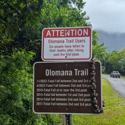
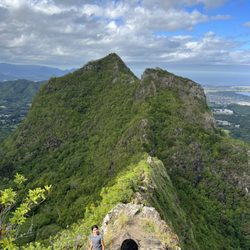
    This is not for the faint of heart. First peak is an hour and a half of serious cardio. Rope…read moresections and rapid, steep elevation. Pic is from second peak. Don't forget to bring enough water and snacks.

    Tl:dr: the most technically challenging hike on the island, takes 5-6 hours round trip including…read morestops on each of the 3 peaks to take pictures, rest etc. People talk about mortality on this trail, although I don't think it's as dangerous as people made it out to be if you exercise common sense. Who should do it: most people can make the 1st peak. Trail from 1st to 2nd becomes noticeably narrower but it's short and about the same level of difficulty as trail up the 1st peak. 2nd to 3rd peak was where the challenge is - lots of vertical rock climbing, path is narrow, and ropes aren't all in good conditions. If you don't have good upper body strength, have knee problems, or are afraid of heights, it's not a good idea to do the 3rd peak. If you don't have good endurance, it's just going to be a long day. Words of caution: try avoid going after a rainy day because the trail becomes very muddy. It started raining when I was coming down from the 3rd peak and the ground became slippery. Better to go with a friend if you can - there are only a few people hiking past the 2nd peak and in case you get injured, it's good to have someone with you to help. Preparation: pack enough water, gloves (protect your hands from climbing), long pants, and a light windbreaker (waterproof is ideal). You never know how the microclimate changes in the mountain. Throw on some hiking shoes too if you have them. You can get away with gym shoes as I did but extra grip comes in handy on a muddy day. Views: view is the best from the 1st peak. Past that is more for the adrenalin and experience. Parking: no official parking lot for the hike, park across the bridge on the side of the roads. It's a ~15 minute walk to the trailhead. Have fun out there!

    Photos
    Olomana Hike
    Olomana Hike - "I've been Here" or Geocache box and some emergency ropes

    "I've been Here" or Geocache box and some emergency ropes

    Olomana Hike - Third peak looking back at First and Second

    See all

    Third peak looking back at First and Second

    Likeke Falls - Fallen branch

    Likeke Falls

    4.3(127 reviews)
    6.1 mi

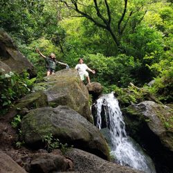
    I've have made this short hike a few times, today the falls were flowing more than the other times…read more It was so peaceful and beautiful to see so much water flow. Trail was a little muddy in spots but not bad. There was a tree across the trail right by the area that you take the trail to the right to head to the falls. There is some ups and downs, high steps ups, lots of roots, so keep your eyes on the trail. Alltrails is helpful to stay on trail.

    Nice woodsy falls a reasonably easy hike up through the jungle. Hiking from the road to the golf…read morecourse parking lot adds about a half mile and is as long or longer than the jungle hiking. The falls are maybe 30 feet high down the rock face. If you go up to the base there is a pool deep enough to dip all the way into, with some lower pools just deep enough for a foot soak. The trailhead is on the far left side of the golf course parking lot as you come up from the road. The trail is wide to start, then just before you hit the big water tank the trail goes off and up to the left. A little ways in there are two big downed trees, and the trial to the falls takes a hard turn to the right. Straight/left goes away from the falls but there are a bunch of trees across the trail a half-mile or less down the trail. The falls trail continues down the farthest left fork below the falls. You follow the blue and pink ribbons, and eventually they split. The pink goes down along the streambed. The blue seemed to go up the streambed and involves some serious rope climbing, but then I lost the trail and couldn't see any more blue ribbons.

    Photos
    Likeke Falls - Just hanging around!

    Just hanging around!

    Likeke Falls - Still going...

    Still going...

    Likeke Falls - Getting there...

    See all

    Getting there...

    Maunawili Trail - Follow this sign downhill to the stream and the waterfall.

    Maunawili Trail

    5.0(2 reviews)
    6.1 mi

    Gorgeous shaded hike through lush green forest! Uneven dirt terrain that is rocky & pretty…read moremuddy/slippery after a good rain. The waterfall at the end is beautiful, surprisingly cold & reviving to jump into! It's between 5-6 miles round-trip. A fun & beautiful hike!

    PARK ON THE HIGHWAY AT THE SCENIC POINT PULLOUT (leave a completely empty car, as there have been…read morebreak-ins here before). Really cool rainforest trail. Mostly shaded. **Wear trail shoes** for the multiple slippery patches of mud you'll surely encounter (and keep a clean pair of sandals in the trunk for the drive home). We did this hike in early September '21 from the Pali Highway viewpoint entrance (because the more traditional neighborhood entrance was closed for a 2-year renovation project). I'd rate this hike 4.5 stars; of our six Oahu hikes this trip, this trail was my 2nd favorite (my favorite Oaho hike is the Kuliouou Ridge Trail).. WHAT I LIKE ABOUT THIS HIKE: It is a good workout (roughly 7miles and 2K feet elevation gain to the waterfall and back), there was varied terrain and views to keep me interested most of the way, and it was shaded throughout most of the trail, making it a great hike to do on a hot day (which it was the day that we went). Although the trail is clearly marked, there are a couple of places where it splits, and thus I'd recommend downloading the trailmap to your phone via Alltrails here, https://www.alltrails.com/trail/hawaii/oahu/maunawili-falls-from-pali-highway?u=i , so that you have a good feel of where to turn at forks. Some of the minor downsides (half star deduction): - There is minor overgrowth in a portion of the trail (not full blown bushwhacking, but definitely some flora rubbing up against ones legs for maybe a total of 1/4 to 1/2 mile in each direction). -- nothing pointy enough to cut you though (see pic of ferns) - There was a single exposed section of cliff that was about 5-10 feet in length, but there was an anchored rope attached to the wall that made me and my wife (who is scared of heights) feel comfortable crossing it (to tell you the truth, I was surprised my acrophobic wife was fine crossing that section, but surprisingly she was). (see pic with my hand on the yellow rope) - There were occasionally patches of mud that one had to navigate through, but it was all on flat portions and so with the proper trail shoes there wasn't really a danger of slipping; - My wife got freaked out by the single sign near the beginning of the trail that said or depicted the danger of picking up ordinance (i.e. it explodes); clearly any such ordinance must be off the trail, as we hiked the whole trail (which is clearly marked) and never saw any metal. - One needs to keep moving past the beautiful stream, rather than stopping there for a 10 minute lunch (unless one is Deeted up with bugyspray that is); we stopped there for lunch only to find out that mosquitoes hang out there and were chomping at our legs the whole time.....no mosquitoes anywhere else on the trail, and had we not stopped at the stream to eat lunch, I am confident we wouldn't have even gotten a single bite. - The parking area to the entrance, which is a viewpoint area on the highway, has suffered car breakins; we were weary leaving our car rental (for which I opted out of the insurance) there when we saw broken car window glass from previous break-ins, but we decided that given that our car was completely empty of anything to steal we'd take the chance. We were hiking for 4 hours, and fortunately when we returned our car was in tact just as we'd left it

    Photos
    Maunawili Trail - Plant life brushes up against one's legs and ocassionally against one's arms in the patches like this.

    Plant life brushes up against one's legs and ocassionally against one's arms in the patches like this.

    Maunawili Trail - Yellow rope anchored to wall to comfort you as you cross over this 5'-10' foot section of exposed cliff.

    Yellow rope anchored to wall to comfort you as you cross over this 5'-10' foot section of exposed cliff.

    Maunawili Trail - There is really only one hazardous cliff IMHO; see the picture with the yellow rope

    See all

    There is really only one hazardous cliff IMHO; see the picture with the yellow rope

    Friendship Garden - The Ridge Lookout - go left when the trail splits... For a beautiful View of Kaneohe Bay!

    Friendship Garden

    4.4(74 reviews)
    3.4 mi

    Friendship Garden has 72 reviews as of 1/17/2025 and I was wondering why. I think the name explains…read moreit. It's a short, garden trail inside a neighborhood rather than a real hike. As I was walking this trail, my brain is telling me this is a mini Aiea loop trail with great view of the Windward side of Oahu. Parking is a challenge. The location is inside, one way, Kokokahi Place neighborhood so there's only street parking. We were lucky to find spacious area to park. The view here is great considering we only hike up 20-30 minutes. Total trip length was 2 miles. That was little disappointing because I like to get most out of my hikes. I feel like I got ripped off on this hike with little sweat. As for intensity, you do have to climb up but lots of ropes to help you. Luckily it was a dry day so no mud. This trail is quite narrow so it may not be kid friendly. Also, if you're on the taller side, watch out for branches. This is not State trail so it seems like it's not kept up regularly.

    If you need an escape from daily life to catch a breath and rekindle friendships, then the…read moreFriendship Garden is the perfect place. This is a very short hike that loops around, so you shouldn't be running into anyone on the narrow pathway. Start right, like driving! There's nothing steep, treacherous, or difficult. The Friendship Garden is very well maintained. Maps and information are provided at the beginning. At the top, you'll find beautiful views Kaneohe Bay. There's also a pathway that leads to another hike that's clearly more difficult and not apart of the Friendship Garden. Warning signs posted! The only difficult thing might be finding this place because it's quite hidden, deep in a residential area. It's located on Kokokahi Pl, which you can reach from Kaneohe Bay Dr. Just drive all the way up, and it'll be to your left. You can only park along the side of the road. Make sure to leave enough space, and also be mindful of the signs! No parking from 6-11AM on Wednesdays and Saturdays, which is probably trash pick up days. Overall, a really nice, easy hike with well maintained pathways. It might be a journey to get there, but it's worth it. Bring friends and make new friends!

    Photos
    Friendship Garden - Pretty and rare

    Pretty and rare

    Friendship Garden - Cony's birthday was spent with her best friends - Brown and Choco!

    Cony's birthday was spent with her best friends - Brown and Choco!

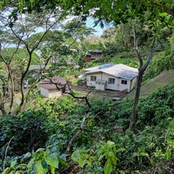
    Friendship Garden - Someone's house is right below

    See all

    Someone's house is right below

    Kaneohe Tower Hill - hiking - Updated September 2026

    Loading...
    Loading...
    Loading...