Cancel

    Open app

    Search

    Lake Apopka Restoration Area/Loop Trail

    4.0 (1 review)

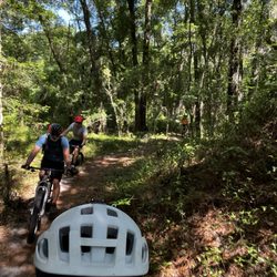
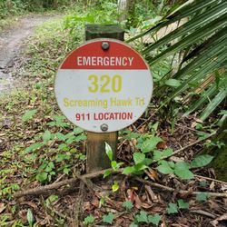
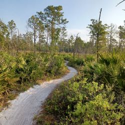
    Lake Apopka Restoration Area/Loop Trail Photos

    You might also consider

    More like Lake Apopka Restoration Area/Loop Trail

    Recommended Reviews - Lake Apopka Restoration Area/Loop Trail

    Your trust is our priority, so businesses can't pay to alter or remove their reviews. Learn more about reviews.
    Yelp app icon
    Browse more easily on the app
    Review Feed Illustration

    4 years ago

    Helpful 1
    Thanks 0
    Love this 1
    Oh no 0

    You might also consider

    Verify this business for free

    People searched for Mountain Biking 156 times last month within 15 miles of this business.

    Verify this business

    Mount Dora Bike Trail

    Mount Dora Bike Trail

    4.9
    (7 reviews)
    10.3 mi

    Great underused trails. Short but sweet.. 4 miles of technical butchery…read more.. Have been visiting this trail on and off for a dozen years now... For the most part they have remained nearly original with only a few refinements... Refinments for the better I should add... This is not the longest, or most technical trail around but it's four mile loop will work you hard... This is despite its decieving, mostly blue and green trails... It is well marked and the local volunteers Keep it well maintained... The trails are entirely canopy covered and beautiful enough for just a leisure pedal through the woods.. But with the elevation changes and switchback there is no time for a leisurely ride... This is an honest four mile trail that will work you... Better be prepaired for a challenge when you get here... Enjoy...

    This is a very well maintained mountain bike system. It's comprised of about three miles of…read morebeginner and intermediate trails and an additional 2 miles of expert level Trails. There is also a skills park at the entrance to practice some built elements before encountering them on the trail. It's located by the MT Dora dog park, behind the softball fields. There is the right amount of parking. That is, if the lot is full, then so its the trail and you'll probably be either frustrated behind someone slower than you or frustrating someone who's faster and stuck behind you. That being said, 90% of the folks I've met riding have been nothing but pleasant. You'll find the occasional rider "doing it for Strava" but that's fine. Just roll with it (ba da boom) and roll your eyes while you stick w your pace. Sure there are other more elite trails in central Florida. But for a quick after work ride, this one hits the spot.

    Photos
    Mount Dora Bike Trail
    Mount Dora Bike Trail
    Skillzville area - Photo credit: Alex A.

    See all

    Skillzville area - Photo credit: Alex A.
    Chuck Lennon Trails

    Chuck Lennon Trails

    4.0
    (3 reviews)
    37.4 mi

    Chuck Lennon is a Park and MTB Trail that does not get too much recognition only because of the…read moreother well-known MTB parks an hour of its surrounding areas. But this place is definitely worth checking into. The park has amenities; Bathroom, Bike Washing Station, Playground, Soccer Fields, amongst others.   There are enough trails equipped within this trail network to satisfy all type of different skill set riders. The first trail entrance from the parking lot alone leads you to a small pump track to get your blood pumping...then it tails off to the Intermediate, Advance Trails and Jump lines areas as well as some novice, flat trails.   And if that is not enough, just ride across the parking lot, where you will meet a separate trail on its own called Awesome Possum. This trail has some Intermediate trail areas, but for the most part, it is mainly Cross Country (green) trails.   All the trails here are well maintained and well-marked for especially for emergency situations.   The only caveat about Chuck Lennon is it is not an ideal place to ride when it has rained days prior. This is when majority of the Intermediate and Advanced trails would likely be closed due to their slippery conditions.   Other than that, who would not want to enjoy a new trail to visit. So come on by check out what these trails has to offer.

    This is a wonderful park and bike trail system! If you are biking- you will have lush green Florida…read moreforest to mountain bike through. The bikers we chatted with love the trails here- we dipped in to look at the maps for future visits. There are 2 small parking areas for biking and then further down the road is a sports complex and playground and a bigger parking lot. For a Sunday afternoon the park was pretty busy- people biking, playing basket ball, pitching a baseball back and forth. The laughter from the playground made me smile! Big open spaces- there is a cattle ranch that borders the road leading into the park- just a breath of fresh air- literally!

    Photos
    Trail map
    Trail map
    Trail Markers: in case you get injured or need help
    Trail Markers: in case you get injured or need help
    Bear them in mind

    See all

    Bear them in mind
    Little Big Econ State Forest

    Little Big Econ State Forest

    4.9
    (25 reviews)
    35.9 mi

    I entered at the Jones East Trailhead, which has plenty of parking and also has restrooms at the…read moreentrance to the trailhead. Walking the trailhead was relatively simple and relaxing. I did encounter a few other people (they were either walking like myself or on a bicycle). The path itself is somewhat narrow, but it was enough for us to pass each other with no real inconvenience. Little Big Econ State Forest is a pretty cool place to check out. Walking the path, it was easy to forget that you were just outside of a major United States city in the twenty-first century. I seek out these spots where I can walk through the trees and forget the troubles of living in a modern city in today's modern world. Little Big Econ State Forest is a cool place to seek out if you are looking for a respite from the hustle and bustle of the modern world.

    This state forest is about a 25 minute drive from downtown Orlando. We highly recommend it. They…read moreoffer maps at the start of the trail. So lush and peaceful. The stream along side most of the trail is beautiful. There are many benches along the path that offer a nice view of the scenery with shade. We took our pups and hiked for about 2 miles. The hikes range from 3 - 10 miles. I saw they do offer camping as well. Make sure to pack some water. It was nice to see many tamiles and couples enjoying the outdoors. We loved the variety of scenery and that it has lots of natural shade throughout the hike.

    Photos
    Shaded trail
    Shaded trail
    Little Big Econ State Forest
    Maps available

    See all

    Maps available
    Markham Road Trail

    Markham Road Trail

    4.0
    (2 reviews)
    21.1 mi

    This is a very good trail; but wait, there's two trails…read more There's a separate mountain bike trail, and then there's the cement paved trail. We did both on our visit but you have to have a bike that can withstand sand cause if you don't you'll have to get off and push your bike like I had to on several parts of the paths. However; it was not in vain because we got to see deer that are apparently not afraid of people and come up real close to you. It seems like they're use to having people feed them. Then there's the cement trail which takes you through the beautiful neighborhoods and you see trees and pass by farms with horses and kinds of farm animals. It's very nice and relaxing. The parking area for this trail is chock-full-o goodies! Restrooms, an area for you to even rinse off your bike, and to put air in it.

    Checked this mountain bike trail out for the first time this weekend and enjoyed it (writing this…read moreas a beginner MTB rider, btw). It is built and maintained by SORBA and according to their website is about 2.5 miles long. Finding the trail head and parking lot was a breeze. Bathrooms directly adjacent to the trail head. This trail is about 60% open, scrub land with somewhat wide trails suitable for a beginner. The open spaces duck occasionally for short jaunts through treed single track while staying mostly flat. I did the main loop and decided to try out the blue trail that heads south for about .4 miles... This portion was cut through saw palmettos and featured lots and lots of jarring root knots. It made for a not too fun ride! I got to the end of this short piece and decided to take the fire road back to the main loop. I'd had enough, lol. I saw on the map that there was more trail to be had but I'll check it out another time. The trail is mostly well marked but I did get turned around one time. No big deal since I was the only one out there this morning. I did come across TONS of deer. It seemed like every time I turned a corner deer were jumping out of the way. After I realized what they were it was very cool to have them out there with me. Overall a scenic, if mostly flat, ride on a well-maintained trail. I'll be back!

    Photos
    Welcome!
    Welcome!
    Terrain
    Terrain
    Map

    See all

    Map
    49th Ave Trailhead

    49th Ave Trailhead

    4.0
    (3 reviews)
    39.2 mi

    49th Ave Trailhead is a system of trails that connects 13 miles from the main Santos Trails. It is…read morea well kept trail in my opinion. The trail gives you The Good, The Bad and The Ugly when it comes to trail riding. The trail features 3 trails: Nayls South (The Good), is mainly a green rated (easy), single track trail. It's very flowy, making it ideal trail for cross country riders. Then you eventually hit a blue rated (more difficult) trail Nayls North (The Bad), which is a bit more challenging compared to its South counterpart because of the changes of elevation and many rooty areas you encounter along the way, making for a bumpy ride. Then there is The Ugly, which is Ern N Burn, a scenic blue rated trail that eventually marries itself to the Troll Bridge, a short, technical, yet fun trail. And it feels like a scavenger hunt when it comes to finding that infamous Troll and so satisfying once you do. Additionally, you will cross into the Cross Florida Greenway Trail, a paved path that crosses path in between all the trails. You will often find many road bikers using this system. It also makes for a great bailout option if you want to get away from riding on the trails. All in all, I really enjoyed this trail and cannot wait to come back.

    Not much of a park, actually kind of small. Probably not much more than an acre. One pavilion in…read morethe center with a couple picnic tables and a couple port-a-potties make up the facilities. A dirt road encompasses the whole thing with several spaces to pull in and park. Several spaces big enough for horse trailers. The parks true attraction is that it's the trailhead for biking, hiking and horse riding on some of Florida's most scenic trails. With some 60 or so miles of each mentioned type trail there is plenty of room for everyone.

    Photos
    Cross Florida Greenway. Pavement riding
    Cross Florida Greenway. Pavement riding
    Easy going down, not so fun on the way up
    Easy going down, not so fun on the way up
    Land Bridge: Bridge that connects 49th Ave to Santos Main Trailhead

    See all

    Land Bridge: Bridge that connects 49th Ave to Santos Main Trailhead
    Haile's Trails Mountain Bike Trail

    Haile's Trails Mountain Bike Trail

    5.0
    (1 review)
    87.5 mi

    Hailes Trails.... I want to call it "HELLS Trails". This mountain bike trail is by far the most…read moredemanding trail I've ever ridden in Florida.   Hailes Trails is a privately owned property located in Newberry, just on the outskirts of Gainesville, FL and it is closely adjacent to Gatorback Cycle Park. The property is opened up to the public only Once/Twice a Year.... Saturday being a pre-ride event to the public and on Sunday, it host Florida State MTB Championship series for all registered bikers. The trail is carefully marked, taped and prepped for such event.   The trails consist of a 2 parts series: 1st trail spanning for 2 miles and 2nd trail being 3 miles worth. All in all, you get 5 total miles of a mixture of rooty, rocky, steep climbs and descents type trails, and some technical turns in between.   The trails runs in and out an old rock quarry, which offers a nice scenic view and numerous elevation changes. It is rated as an advanced trail, but caters to any intermediate skill level riding and beyond. Admission to Hailes cost $5 per person and a waiver is needed to be signed at the time of payment.   Hailes proved to me that Florida IS NOT as flat of a state as you think it is. Lawd have merrsay !!!   But I loved every bit of it and I cannot wait to go back again, so I say Hailes Yass !!!   And if you don't like it... Bike Me =)

    Photos
    Peace
    Peace
    Hailes Trails: A private property that opens up to the public once/twice a year during MTB Race weekends (September 2020)
    Hailes Trails: A private property that opens up to the public once/twice a year during MTB Race weekends (September 2020)
    Hailes Trails: A private property that opens up to the public once/twice a year during MTB Race weekends (September 2020)

    See all

    Hailes Trails: A private property that opens up to the public once/twice a year during MTB Race weekends (September 2020)

    Lake Apopka Restoration Area/Loop Trail - mountainbiking - Updated June 2026

    Loading...
    Loading...
    Loading...