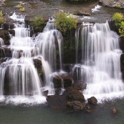
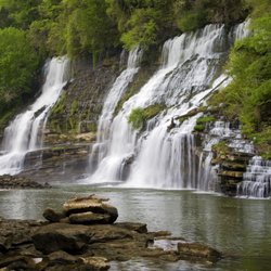
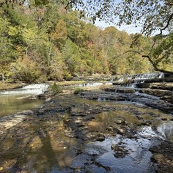
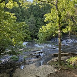
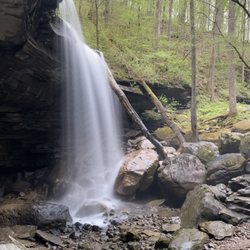
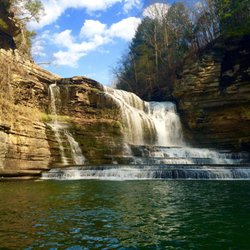
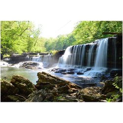
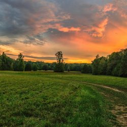
Lost Creek State Natural Area Photos


More like Lost Creek State Natural Area
Recommended Reviews - Lost Creek State Natural Area
Start your review...

4 years ago
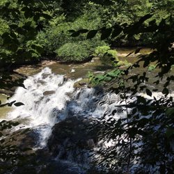
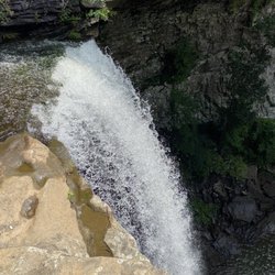
This was my favorite place in Tennessee ever! It's a beautiful twisty turny drive and the falls are not too far from the car. It is a steep downward walk then you must be able to walk over lots of rocks and back up to your car. You can go all around and under the waterfall and in the pool. It's shallow and perfect for kids. The rocks are slippery so have some water shoes. My mom and Auntie could only come down about 100 feet so they put their chairs on the steps and waited for us. Their is no bathroom around so use the restroom on the way. The cave is close to the falls and it feels like someone turned on the air conditioner. It is awesome on a hot summer day. But watch your steps carefully. The whole ground is full of boulders and loose rocks to step over and sometimes muddy soil. We finished our day driving to fall creek falls state park to see the views there. read more


2 years ago
We went here recently for a small hike. Great waterfall and a nice short hike for kids. The cave was closed for hypernating bats but looks amazing. I would definitely go back again read more


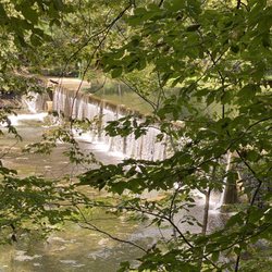
This is a gem in eastern Tennessee owned by the state. It is not real easy to find and a little difficult to get to but the waterfall and spectacular cave is well worth the trip. You must park on the side of the road, go down the stairs travel a short distance to see the beautiful waterfall. Then just across is a cave. I tried walking inside but there are so many rocks piled up that it makes it very difficult to go very far. Lost Creek is one of the larger caves in Tennessee. This natural area is situated on the western flank of the Cumberland Plateau. With five entrances and seven miles of mapped passages, it makes for an adventurist day. This natural area is covered with diverse trees, wildflowers, ferns and mosses. Open to the public from sun up to sun down year round. read more


More info about Lost Creek State Natural Area


Lost Creek State Natural Area - hiking - Updated June 2026
Best of Sparta
People found Lost Creek State Natural Area by searching for…
Hiking Trails With Waterfalls in Sparta, Tennessee
Waterfalls in Sparta, Tennessee
Scenic Drive in Sparta, Tennessee
Things to Do in Sparta, Tennessee
Beautiful Views in Sparta, Tennessee
River Swimming in Sparta, Tennessee
Swimming Lakes in Sparta, Tennessee
Attractions in Sparta, Tennessee
Places to Swim in Sparta, Tennessee
Places to Take Pictures in Sparta, Tennessee
Dinosaur Park in Sparta, Tennessee
Swimming Holes in Sparta, Tennessee
Easy Hikes in Sparta, Tennessee
Fishing Spots in Sparta, Tennessee
Scenic Views in Sparta, Tennessee
Photo Spots in Sparta, Tennessee
Running Trails in Sparta, Tennessee
Lookout Points in Sparta, Tennessee
Flower Fields in Sparta, Tennessee
Walking Trails in Sparta, Tennessee
Trending Searches in Sparta, TN
Bird Sanctuary near Lost Creek State Natural Area
Black Owned Nail Salons near Lost Creek State Natural Area
Boat Rental near Lost Creek State Natural Area
Cliff Jumping near Lost Creek State Natural Area
Day Trips near Lost Creek State Natural Area
Dog Friendly Things To Do near Lost Creek State Natural Area
Fishing Spots near Lost Creek State Natural Area
Kayak Rental near Lost Creek State Natural Area
Lakes near Lost Creek State Natural Area
Parks For Picnics near Lost Creek State Natural Area
Pick Your Own Farms near Lost Creek State Natural Area
Places To Swim near Lost Creek State Natural Area
Pool Supplies near Lost Creek State Natural Area
Public Shower near Lost Creek State Natural Area
Rock Quarry near Lost Creek State Natural Area
Scenic Overlook near Lost Creek State Natural Area
Splash Pad near Lost Creek State Natural Area
Strawberry Picking near Lost Creek State Natural Area
Swimming Holes near Lost Creek State Natural Area
Swimming Lakes near Lost Creek State Natural Area
Watch Sunset near Lost Creek State Natural Area
Browse Articles
Browse Brands
Related Searches in Sparta, TN
Affordable Kayak Rental Services in Sparta, Tennessee
Best Fishing Locations and Guides in Sparta, Tennessee
Best Fun Things to Do in Sparta, Tennessee
Best Places for Horseback Riding in Sparta, Tennessee
Best Water Parks for Kids in Sparta, Tennessee
Best Waterfalls and Swimming Holes in Sparta, Tennessee
Check Out Great Playgrounds in Sparta, Tennessee
Check Out Off Road Trails in Sparta, Tennessee
Discover Baseball Fields Around Sparta, Tennessee
Discover Dog Friendly Trails to Explore in Sparta, Tennessee
Discover Fun Activities to Do in Sparta, Tennessee
Discover Popular Photo Spots in Sparta, Tennessee
Discover Scenic Waterfall Spots in Sparta, Tennessee
Discover Top Boat Tours in Sparta, Tennessee for All Ages
Discover Top Nature Parks to Visit in Sparta, Tennessee
Discover a Hiking Trail in Sparta, Tennessee
Discover the Best Beaches in Sparta, Tennessee
Discover the Best Fishing Lake in Sparta, Tennessee
Discover the Best Night Hike Trails in Sparta, Tennessee
Dog-Friendly Hikes With Dogs in Sparta, Tennessee
Enjoy Exciting Mountain Biking Adventures in Sparta, Tennessee
Enjoy Tent Camping Spots Around Sparta, Tennessee
Enjoy the Best Tubing Experiences in Sparta, Tennessee
Enjoy the Best Walking Trails in Sparta, Tennessee
Exciting Cliff Jumping Spots in Sparta, Tennessee
Explore Beautiful Parks and Green Spaces in Sparta, Tennessee
Explore Bike Rentals Throughout Sparta, Tennessee
Explore Easy Hikes Perfect for All in Sparta, Tennessee
Explore Family-Friendly Zoos and Wildlife in Sparta, Tennessee
Explore Fun Activities to Do in Sparta, Tennessee
Explore Landmarks & Historical Buildings in Sparta, Tennessee
Explore Parks With Pull Up Bars in Sparta, Tennessee
Explore Popular Campgrounds Near Sparta, Tennessee
Explore Popular Picnic Areas Around Sparta, Tennessee
Explore Popular RV Parks Around Sparta, Tennessee
Explore Popular Recreation Centers Around Sparta, Tennessee
Explore Popular Scenic Overlook Points in Sparta, Tennessee
Explore Popular Scenic Views Near Sparta, Tennessee
Explore Scenic Lakes to Visit in Sparta, Tennessee
Explore Top Dog Parks in Sparta, Tennessee Near You
Explore Top Gyms in Sparta, Tennessee Now
Explore Top Water Parks in Sparta, Tennessee Today
Explore the Best Boating Spots in Sparta, Tennessee
Explore the Best Swimming Holes Around Sparta, Tennessee
Family Friendly Hiking With Kids in Sparta, Tennessee
Find Beautiful Views in Sparta, Tennessee
Find Parks and Recreation Activities in Sparta, Tennessee
Find Popular Ziplining Spots Around Sparta, Tennessee
People who viewed Lost Creek State Natural Area also viewed
Rock Island State Park
81 reviews
Ozone Falls
39 reviews
Ozone Falls
6 reviews
Burgess Falls State Park
81 reviews
City Recreation Park
1 review
Central Trails Paved Paths Nature Trails
1 review
Lover's Leap Overlook
1 review
Obed River Park
1 review
Kayaking Adventures of Tennessee
12 reviews
Crossville Dog Park
6 reviews