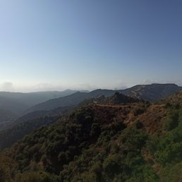
Mandeville Canyon Fire Road Photos


You might also consider
More like Mandeville Canyon Fire Road
Recommended Reviews - Mandeville Canyon Fire Road
Start your review...

Reviews With Photos

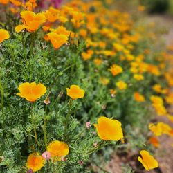
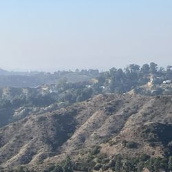
Mandeville is one of my favorite hiking spots. A small parking lot is available at the hike entrance but I've seen some overflow into the residential areas (please be respectful if parking there). It is dog friendly which is a plus for me. The well maintained fire road is paved although recent rains have opened up some cracks. There's diversions where you can climb the humps for some incline. Mandeville usually stays quite green even during the summer and the flowers springing up recently makes it more beautiful. Beware of spots with droves of flies and watch out for bikers whizzing by.

Hiked on 4/16/2023. Found street parking close by. Love how dog-friendly this trail is!! So many friendly , cute dogs running off-leash. Beautiful views. Subtle incline. Only downside of this hike = hardly any shade! Would recommend early AM hiking to avoid the heat. Wear a hat & sunscreen.
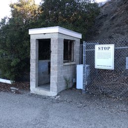
Go early in the morning to avoid the heat as the sun starts coming up. This hike took about 2 - 2.5 hours with moderate rest at the top. It is about a 7 mile round trip. The road will split up two ways in some sections; the left side is easier and the right side is harder / steeper. Both trails will still merge and eventually end up going the same way. Entrance is located deep in residential area and parking at the trail is limited to about 10 cars. If there is no parking at the trail, you will need to park on the residential streets and then walk up.
It took me about an hour and a half to get to San Vicente Peak from the start of the trail. From there I walked around the LA96C Nike Missile Control Site. I saw restrooms at San Vicente Peak but the women's restroom was out of order. You can use it but it ain't gonna flush. At the start of the trail something in the air stung my eyes a little. Then I overheard another biker say they spray the dirt trail with phosphate. I'm not sure exactly sure what they use to spray the trail but watch out if you have sensitive eyes. The bikers that go by will kick up a lot of dust in the air so make sure you bring some kind of face covering. There is a lot of dog poop and unleashed dogs. Most dogs are friendly and will walk towards you if they see your water bottle. I saw one man with two dogs who brought no water for himself or his dogs. His poor dogs looked tired and it was a warm day. Please take of your dogs especially on hot days! It's not likely you will find parking in the small lot but there is plenty of street parking.

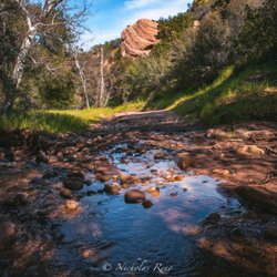
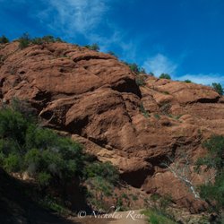
A 6 mile gravel trail that has scenic views. Right now Spring is just starting to show with yellow and pink wildflowers already sprouting. We went a few days after the rain and there were small areas of mud and a rather strong water current flowing on a neighborhood roadside. The road up to parking is a bit rocky with large potholes

Great trail in the Santa Monica amounts above Brentwood/Santa Monica. Easy to get to and ample parking. Also nice that it's not busy so you have a lot of solitude there. The fire roads go for miles so you have plenty to explore. Also great for a bike or if you just want to get away from the city without having to leave the city. Also a good alternative to Runyon Canyon which is fun but very crowded and sometimes difficult to find parking at. Parking is free here. Enjoy!

Came here on a Sunday afternoon and it is really pretty! I definitely felt like I did get a work out in. Nothing here was too steep to scare me. The only problem is that there are a LOT of flies, at least on a sunny Sunday afternoon. The cool thing about this hike is that you can kind of choose your own adventure. We chose an easy hike, but I see there are more trails or destinations we could have taken as it is huge.

I'm laying here after hiking and I don't know if it's the sun or just taking the more challenging parts of trail but I'm tired... lol This is a nice hike. What I like about it is that it is challenging enough to hike/run without being disappointed that there were no ocean views because of the haze. There is no shade so be sure to stay hydrated or hike closer to sunset. This trail is dog-friendly so be on the lookout since some people some don't pick up after their dogs. The fire road trail is wide and paved in a way that is versatile enough to hike/bike ride and have your dog off-leash. On this particular day it was kind of hazy so I didn't get the clearest views of the ocean but I read that in a clear day you can see to Catalina. Always be aware that not only are there lizards and snakes but also dog poop to watch for. Also know that some of the mountain bikers come down hill quickly so be alert. This was my first time but I found out about it because I wanted a trail that was close enough that I could take the dog with he visits. I like that there is a parking lot but also adequate street parking. Respect the neighborhood and when you visit we shouldn't have to worry about permits when the lot is full. With nice views, a versatile trail and being another gem on the west side I can say that I would recommend this trail for those looking for a little bit of a challenge. Stay hydrated.

Went on a hike here on a Saturday afternoon with my sister, cousin, and her dog. We enjoyed the scenery and views of the hills and mountains. Many people were there that day taking walks with their dogs and mountain biking as well. The only thing that I wish people would do more is to pick up after their dogs. While we were hiking up, we saw many piles of dog feces and plastic bags on the side of the trails. It's disrespectful and rude that people would just leave waste on the trails, expecting others or city officials to clean it up. Please, out of common courtesy and respect for the area, pick up after your pets!

Finally tried this trail after living in The Palisades for many years and if you like dogs, good views, and a good workout -- GO! It's about 10 minutes North of Mandeville Cyn -- keep going up and up till you hit Golden Road -- or Golden something -- then park. It's a very wide trail / road with lots of hills -- so either come when it's cool or in the morning as it can get hot. I was surprised how close you are to the Valley --as there are great views of Van Nuys airport and beyond. Not the best for Ocean Views -- but on a clear day you can see Downtown LA. Took about 2 hours at a medium pace to do the loop -- which lets you off about 5 min. South of where you parked.

Love riding on this trail/road. If your up near Mulholland you can see both the Westside and Santa Monica and the Pacific. Its a great trail to run, bike, hike. Going south its fun and you can pick up some speed to watch it. Its on the return back to Mulholland that you get your workout. I have only MTB up there on this road and it can be challenging yet not too long if you only do that one trail and back. But I love the feeling of getting way and being miles from everyone but really not being too far away. Just be careful on the decent for people coming up the hill and watching your brakes. Lately LAFD has been grading the fire road so watch out for the grader during the day. They are done usually late afternoon by 5pm. Enjoy our open space and lets keep it that way!

I love to hike and this place was great. You get a total view of both the city of Los Angeles and the ocean. There are not too many places where you can get such a view. This place is super dog friendly and I would say over 50% of the people there had dogs. There are also quite a few bikers. But plenty of room for everyone to walk. It's not an extremely difficult hike but you can make it more difficult on yourself depending upon which route you decide to choose. It was the perfect hike for frankly the day after a lot of drinking.

Love the trails here! Lately, during the sunset hours, the weather has been good and wasn't too cold or windy out. Although, I can imagine during the afternoon it can get really hot, because lack of shading, large trees to cover. So bring sunblock and water, if you're out during the afternoon hours. Several other hikers bring their dogs out here, sometimes off leash, just FYI. There are doggie waste bags available for free here too. There is a path that deviates from the fire road, which has steeper points for more of a good workout. Usually, my friend and I walk/hike up the steeper trail and run back down the fire road. If you enter and start the trails on Westridge and hike up to "the tower" the sunsets and DTLA city lights are epic sites! Worth watching and admiring the 50 shades of sky colors up there :)

2 years ago
One of my favorite trails in the Santa Monica mountains and the end of the trail is considered one of the highest points within the Santa Monica mountains at about 1,920 feet. There are clean restrooms at the end of the trail. I also noticed some picnic tables near that area too. In the event you're a hiker that needs to fuel up with snacks in your backpack like me, the picnic tables at the end of the trail make a nice spot to rest in the shade before heading back. This trail is shared with bikers, runners, and walkers alike. Even though it is wide enough to accommodate everyone, it seems no one group tries to hog up rhe wide space like some other trails in the area do. read more


I've been at this hiking spot twice now and each time I regret not coming here more often. Let me tell you, the views of this place does not disappoint at all!! Not to mention what a great workout you can get out of it, even if your just walking. The hills are no joke! Wear proper hiking shoes for sure! There is a small parking spot at the beginning of the trail but it gets full fast anytime of the day. So I just found street parking. Even though it has not been raining lately, the mountains were super green and lush! Beautiful 360 views everywhere! Not shaded so take sunscreen, sunglasses and a hat as needed! Enjoy! read more


11 months ago
3 years ago
Mandeville is one of my favorite hiking spots. A small parking lot is available at the hike entrance but I've seen some overflow into the residential areas (please be respectful if parking there). It is dog friendly which is a plus for me. The well maintained fire road is paved although recent rains have opened up some cracks. There's diversions where you can climb the humps for some incline. Mandeville usually stays quite green even during the summer and the flowers springing up recently makes it more beautiful. Beware of spots with droves of flies and watch out for bikers whizzing by. read more

1 year ago
3 years ago
Hiked on 4/16/2023. Found street parking close by. Love how dog-friendly this trail is!! So many friendly , cute dogs running off-leash. Beautiful views. Subtle incline. Only downside of this hike = hardly any shade! Would recommend early AM hiking to avoid the heat. Wear a hat & sunscreen. read more


Go early in the morning to avoid the heat as the sun starts coming up. This hike took about 2 - 2.5 hours with moderate rest at the top. It is about a 7 mile round trip. The road will split up two ways in some sections; the left side is easier and the right side is harder / steeper. Both trails will still merge and eventually end up going the same way. Entrance is located deep in residential area and parking at the trail is limited to about 10 cars. If there is no parking at the trail, you will need to park on the residential streets and then walk up. read more


It took me about an hour and a half to get to San Vicente Peak from the start of the trail. From there I walked around the LA96C Nike Missile Control Site. I saw restrooms at San Vicente Peak but the women's restroom was out of order. You can use it but it ain't gonna flush. At the start of the trail something in the air stung my eyes a little. Then I overheard another biker say they spray the dirt trail with phosphate. I'm not sure exactly sure what they use to spray the trail but watch out if you have sensitive eyes. The bikers that go by will kick up a lot of dust in the air so make sure you bring some kind of face covering. There is a lot of dog poop and unleashed dogs. Most dogs are friendly and will walk towards you if they see your water bottle. I saw one man with two dogs who brought no water for himself or his dogs. His poor dogs looked tired and it was a warm day. Please take of your dogs especially on hot days! It's not likely you will find parking in the small lot but there is plenty of street parking. read more


5 years ago
3 years ago
A 6 mile gravel trail that has scenic views. Right now Spring is just starting to show with yellow and pink wildflowers already sprouting. We went a few days after the rain and there were small areas of mud and a rather strong water current flowing on a neighborhood roadside. The road up to parking is a bit rocky with large potholes read more


4 years ago
Great trail in the Santa Monica amounts above Brentwood/Santa Monica. Easy to get to and ample parking. Also nice that it's not busy so you have a lot of solitude there. The fire roads go for miles so you have plenty to explore. Also great for a bike or if you just want to get away from the city without having to leave the city. Also a good alternative to Runyon Canyon which is fun but very crowded and sometimes difficult to find parking at. Parking is free here. Enjoy! read more


Came here on a Sunday afternoon and it is really pretty! I definitely felt like I did get a work out in. Nothing here was too steep to scare me. The only problem is that there are a LOT of flies, at least on a sunny Sunday afternoon. The cool thing about this hike is that you can kind of choose your own adventure. We chose an easy hike, but I see there are more trails or destinations we could have taken as it is huge. read more

I'm laying here after hiking and I don't know if it's the sun or just taking the more challenging parts of trail but I'm tired... lol This is a nice hike. What I like about it is that it is challenging enough to hike/run without being disappointed that there were no ocean views because of the haze. There is no shade so be sure to stay hydrated or hike closer to sunset. This trail is dog-friendly so be on the lookout since some people some don't pick up after their dogs. The fire road trail is wide and paved in a way that is versatile enough to hike/bike ride and have your dog off-leash. On this particular day it was kind of hazy so I didn't get the clearest views of the ocean but I read that in a clear day you can see to Catalina. Always be aware that not only are there lizards and snakes but also dog poop to watch for. Also know that some of the mountain bikers come down hill quickly so be alert. This was my first time but I found out about it because I wanted a trail that was close enough that I could take the dog with he visits. I like that there is a parking lot but also adequate street parking. Respect the neighborhood and when you visit we shouldn't have to worry about permits when the lot is full. With nice views, a versatile trail and being another gem on the west side I can say that I would recommend this trail for those looking for a little bit of a challenge. Stay hydrated. read more


3 years ago
5 years ago
7 years ago
Went on a hike here on a Saturday afternoon with my sister, cousin, and her dog. We enjoyed the scenery and views of the hills and mountains. Many people were there that day taking walks with their dogs and mountain biking as well. The only thing that I wish people would do more is to pick up after their dogs. While we were hiking up, we saw many piles of dog feces and plastic bags on the side of the trails. It's disrespectful and rude that people would just leave waste on the trails, expecting others or city officials to clean it up. Please, out of common courtesy and respect for the area, pick up after your pets! read more

Finally tried this trail after living in The Palisades for many years and if you like dogs, good views, and a good workout -- GO! It's about 10 minutes North of Mandeville Cyn -- keep going up and up till you hit Golden Road -- or Golden something -- then park. It's a very wide trail / road with lots of hills -- so either come when it's cool or in the morning as it can get hot. I was surprised how close you are to the Valley --as there are great views of Van Nuys airport and beyond. Not the best for Ocean Views -- but on a clear day you can see Downtown LA. Took about 2 hours at a medium pace to do the loop -- which lets you off about 5 min. South of where you parked. read more

Love riding on this trail/road. If your up near Mulholland you can see both the Westside and Santa Monica and the Pacific. Its a great trail to run, bike, hike. Going south its fun and you can pick up some speed to watch it. Its on the return back to Mulholland that you get your workout. I have only MTB up there on this road and it can be challenging yet not too long if you only do that one trail and back. But I love the feeling of getting way and being miles from everyone but really not being too far away. Just be careful on the decent for people coming up the hill and watching your brakes. Lately LAFD has been grading the fire road so watch out for the grader during the day. They are done usually late afternoon by 5pm. Enjoy our open space and lets keep it that way! read more

I love to hike and this place was great. You get a total view of both the city of Los Angeles and the ocean. There are not too many places where you can get such a view. This place is super dog friendly and I would say over 50% of the people there had dogs. There are also quite a few bikers. But plenty of room for everyone to walk. It's not an extremely difficult hike but you can make it more difficult on yourself depending upon which route you decide to choose. It was the perfect hike for frankly the day after a lot of drinking. read more


Love the trails here! Lately, during the sunset hours, the weather has been good and wasn't too cold or windy out. Although, I can imagine during the afternoon it can get really hot, because lack of shading, large trees to cover. So bring sunblock and water, if you're out during the afternoon hours. Several other hikers bring their dogs out here, sometimes off leash, just FYI. There are doggie waste bags available for free here too. There is a path that deviates from the fire road, which has steeper points for more of a good workout. Usually, my friend and I walk/hike up the steeper trail and run back down the fire road. If you enter and start the trails on Westridge and hike up to "the tower" the sunsets and DTLA city lights are epic sites! Worth watching and admiring the 50 shades of sky colors up there :) read more


 - Parks Near Me - Los Angeles, California")
7 years ago
I haven't been here since the fires but I usually go here 1 to 2 times a week with my dog. She and I, love this trail and the gorgeous view. You get a really good workout in too. My dog gets a good workout as well. Parking is easy to find - either right outside the trail entrance or on the side street next to the residential areas. The only thing I don't like about it, is the dog poop. There are a lot of owners who don't pick up after their dogs and it's pretty disgusting! I wonder how things look now since the fires...overall though, this trail is pretty awesome. read more


16 years ago
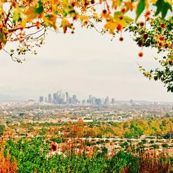
Mandeville Canyon Fire Road was a pleasant discovery. I had no idea such beautiful hiking was available in Brentwood on the eastern side of the Santa Monica Mountains. Thanks to Jean K. for the tip. On a clear day like this past Sunday, the views are tremendous. We could see all the way from Downtown L.A. to Catalina and everything in between. Check out the photos with this review. The road/trail is the entrance to the Westridge Canyonback Park which provides more than 1,400 acres of open space bordered by upper Mandeville Canyon, Sullivan Canyon, Mission Canyon, and San Vicente Mountain Park. The fire road (also called Westridge Fire Road) provides trail access for hikers, mountain bikers and equestrians along the north-south ridgeline. The park is contiguous with the 20,000-acre urban wilderness park known as the "Big Wild." Dogs are permitted off-leash under their owner's immediate control so long as the owner or person in possession of the dog (1) exercises that degree of control that enables such person to recall the dog on command, and (2) has a leash on his person at all times so as to be able to restrain the dog if necessary. Directions from West Los Angeles: Take Sunset Blvd. to Mandeville Canyon Road and go north to Westridge Road. Turn left. Take Westridge Road to its terminus. Need an address for your GPS? Try 2652 Westridge Rd, 90049 because the previous location on Yelp was a couple miles off. Happy Hiking. read more


There's a fire road that begins at the end of Westridge Road in what I guess would be considered Brentwood? Anyway, we took Sunset to Mandeville Canyon Road, took a left on Westridge and went all the way to the end, got out of our car, and just headed up the fire road to the left. Popular with dog walkers, runners, hikers, and bicyclists, we love it because you can walk your dog off-leash. Sophie was in doggie heaven! Lots to smell, lots of dogs, and a dirt road that stretches endlessly into the hills of doggie paradise. There's a steep drop-off on one side that goes almost straight down, and she almost went over the edge chasing some kind of lizard or rodent, but I think even she got scared after that and didn't spend too much time on that ledge. Bikers come up slowly and come down fast, but everyone we met was pretty friendly. There are trails that branch off and climb more steeply, and the views are worth it if you go up 'em, but it's all pretty wherever you look. It's amazing how many wildflowers are still in bloom well into June up there, including some spears rising 10 to 20 feet sometimes from mysterious looking succulents (at least, I think that's what they are. As busy as it was this past Sunday, you can go for stretches without seeing or hearing anyone, and if you go up on one of the ridge trails, you can hear the almost subsonic roar from the city, which was partially cloaked behind some violet smog off to the east. It's a beautiful spot where dog walkers, fitness trainers, and bicyclists seem to exist in perfect harmony, and it was a great way to start a great Sunday morning. read more


This is known to locals as "The Top". Its the top end of the street i grew up on (Westridge Road, and the fam is still there thank god). After school (Pali high school) we'd stuff a 12 pack in our backpack and take off; stomp on our kick starters, and romp til the sun set. There are storm drains at the top of the first hill. You'll find mainly blazers (pot smokers) here most evening/nights sitting looking at the lights and canyons for hours. The view spans 300 degrees from LA downtown to the canyons of Malibu. Just exceptional. We also did Shroomfest 86+87 up here (2 ridges back where you can also see the valley 360deg, but we'd drop at the storm drains at The Top and hike back 2 ridges). In 87 someone stood up and pulled an imaginary lever down and all 12 of us saw all of LA go black for that instant until the switch went back up. Unreal. Um... all my recreational drug use is now a thing of the past... Amazingly... I was in LA this weekend with a neighborhood/childhood friend and we hiked to "The Top" with a few beers after a long night of Sushi and Sake. Still just as beautiful as ever. I plan to be buried here... read more


4 years ago
Nice well maintained wide trail. Busy, but not crowded. Lots of dogs friendly ppl and mountain bikes. read more


11 years ago
Given I hike with an off-leash dog, I have to give Mandeville Canyon Fire Road (aka Westridge Canyon) five stars. I'm not aware of any better off-leash location in or near the Santa Monica area. I heard Runyon Canyon Park was pretty good, but a farther drive for Santa Monica and adjacent locals, and more of a crowd. Most of the dog owners bring poop bags, and there are trash cans for the first quarter mile. If your dog poops up the trail just put your poop bag on the side of the road and pick it up on the way back. The fire road goes for miles so you can spend hours on this hike if you have the time. On the top of the fire road (4 miles), there's a bathroom and a water fountain. If you look over the other side, you can see Encino. I suggest hiking the fire road first (main road), and on a subsequent trip you can try the ridge hiking trail. The ridge hiking trail is much more challenging. For the ridge hiking trail, you should have trail shoes or hiking boots. You'll have to keep an eye out for the mountain bikers coming down but they're generally courteous to the hikers. Additionally, I have heard there are rattlesnakes but I haven't seen any yet. Staying on the fire road is your best bet as the general traffic probably keeps the snakes at bay. In the Spring/Summer I recommend sunscreen, and insect repellent on your legs. The non-chemical repellent Herbal Armor seems to work good enough. The mornings are your best bet. I would suggest bringing water (mainly for the dog). The mornings are a great time for pics when the sun is on the horizon. If your dog is aggressive, you will have to keep him/her on a leash. And I have never had a problem with parking. read more

8 years ago
A slice of heaven. Dogs roam off leash. The sunset comes in pinks and golds. There's a low and high trail depending on your fitness level and timing. And the sound of crickets perfumes the air as dusk falls. I love to come here to reconnect with the bigness and beauty of nature. read more


10 years ago
Great trail! I'd recommend for people with their dogs and those who want an easy stroll. Dogs can run off leash and the way the trail is landscaped, it would be difficult for your pup to get into too much trouble or venture far from you. The trail is wide, spacious, and the views are top notch. There's no shade, so don't go when it's hot out. Not congested with tourists. It's pretty flat so it's an easy walk. read more

quick tips: 1) bring a hat, wear sunblock, and come hydrated. there is ZERO shade on this road. 2) dogs are allowed off leash here, so if you have a little tiny anxious thing, reconsider bringing it. 3) this is actually a dusty fire road. i read such great reviews about this trail and i have to admit i was a little disappointed but i guess it depends on what you're looking for. directions: google mandeville canyon road trail and google maps will bring you right to it. parking: you'll know you've arrived b/c west ridge road dead ends into the parking lot. the lot can only fit 8 cars in it, so just park on the street - there's plenty of it. trail: this is a fire road - that means it's a wide dusty road that the fire department uses in case of - you guessed it - fire emergencies. heading in, you're headed north on the eastern ridge of the canyon. if you look left, there is the western ridge. beyond that, on a super clear non-smoggy day, you can see the pacific ocean. as mentioned, it can get super hot b/c there is no shade. the fire road is pretty flat and wide. you can opt for the hilly option. about a quarter mile in, there is a fork - if you take the left, the fire road continues. if you take the right, it goes up and that trail is more hilly - up and down, and essentially parallels the fire road the entire way. the trail heads north into the canyon and then south on the western ridge. it's about a 3-4 hour walk depending on which road (low or high) you take. a huge plus is that this is one of the few long trails that allows dogs off leash. so bring fido along and let him be free. read more


I found this gem of a trail while researching places to run during my stay here in LA. While I've been to runyon canyon and griffith before, this seemed to be not as crowded which was perfect for me. The drive up is fairly easy; I came from Santa Monica via Sunset and took Westridge until it ended. Be mindful of the sharp curves in the hills. Tons of parking both on the street and in the small little lot. Runners: The trail itself is great and the views are spectacular! I was able to see all along the coast, downtown LA, and peaks of mountains. I also saw a few hawks on my run. It is very peaceful and beautiful but deceiving because it looks easy to run, however I realized a few minutes in that there are several uphill climbs which were challenging. The run downhill was obviously much easier. You might want to consider bringing a change of shoes! My sneakers and legs were so dirty and filthy from all the running. I will definitely be back next time I am in LA. read more

9 years ago
12 years ago
This route is an 11 miles round trip hike with 1,600' elevation gain. The hike is long, but it is pretty easy overall. If you are looking for a difficult, taxing workout, this is not the hike for you. But it will help build endurance training. The trail is wide and smooth, without loose rocks under foot. The inclines are fairly tame and the trail ascends and descends. About 4 miles into the hike, you will arrive at the former NIKE Mission Control Site, which consists of a tower/overlook and a flat area with 2 restrooms. There are panoramic views of the mountains, ocean, and LA in the distance. If you continue on beyond the tower and left , you will eventually reach Sullivan Canyon (follow the sign that leads you down the smaller trail). It will take you through a heavily wooded area with lots of trees and nature. This part of the trail is flat and easy. However, we chose to take a shortcut (at a sign that indicates a preservation area) about 1+ miles from the end of the trail that ends at the paved road. This part of the trail is very, very steep and continues up for about 1/2 mile - very difficult. All in all, this trail is about endurance, not difficulty. And be mindful that you will likely encounter many dogs and cyclists along the way. parking - free, tiny lot or free residential street parking on Westridge Rd read more

17 years ago
Mandeville Canyon: you rock! I'm so glad to have found a dog friendly hike on my side of town. I love Runyon but hate schlepping over there, dealing with parking and the heat (during summer mainly). Mandeville is awesome because there is up to 10 or so miles of hiking and a various levels of difficulty. The hike starts off kind of easy, but if you veer up to the right you can hit the "peaks" and get more hills. We did some sprints up the hills and got a pretty good hour workout in. I love it because it's pretty much empty (we went at 11 on Sat). A few dogs here and there. Lots of mountain bikers (they were all polite). Parking is easy (for now...) and there are great views of the canyons. Hiking here reminds me why I love LA. read more

5 years ago
If your looking to climb hills, this is where to go. There are also alternate paths with low incline that most people end up taking. Don't wear anything that you mind getting dirty and sweaty. But it's a very good workout and the trail is extremely dog friendly. Whenever I go it usually isn't very crowded for some reason, but everyone is usually nice and there is a lot of parking. read more


7 years ago
Such a good hiking trail! I come here specifically because dogs can be off leash and my pup loves it. It's probably more on the strenuous side as far as LA hikes go. There are some steep hills and not a lot of shade so I recommend you get up a little earlier before the sun hits. Very clean, great views, beautiful plants, and friendly people (and dogs). Lots of garbage cans and even doggie bags at the entrance. Parking is scarce within the gate so find a spot on the street. read more

11 years ago
You have a beautiful view of the city ocean & mountains! Great hike for beginners like me and challenging enough for you crazy hikers :p read more


Beautiful, spacious, and somewhat difficult. Just visited this gem today, and can't wait to go back! There are even biodegradable doggy bags in the front and along the trail. Plenty of dogs off the leash, but every single one I met today was friendly. Not much shade, so bring plenty of water and sunscreen. read more

Page 1 of 4
More info about Mandeville Canyon Fire Road
2652 Westridge Rd
Los Angeles, CA 90049
Brentwood
Directions
Hours
Indoor Amenities
Outdoor Amenities
Ask the Community - Mandeville Canyon Fire Road
Review Highlights - Mandeville Canyon Fire Road
You might also consider


Why does Yelp recommend reviews?
Mandeville Canyon Fire Road - parks - Updated July 2026
Best of Los Angeles
People found Mandeville Canyon Fire Road by searching for…
Hiking Trails in Los Angeles, California
Lookout Points in Los Angeles, California
Scenic Night View in Los Angeles, California
Scenic Drives in Los Angeles, California
Off Road Trails in Los Angeles, California
Scenic Overlook in Los Angeles, California
Beaches in Los Angeles, California
Watch Sunset in Los Angeles, California
Dog Friendly Beaches in Los Angeles, California
Off Leash Dog Hikes in Los Angeles, California
Sunrise View in Los Angeles, California
Dog Parks in Los Angeles, California
Hiking Groups in Los Angeles, California
Sunrise Hike in Los Angeles, California
Beautiful Views in Los Angeles, California
Dog Friendly Hiking Trails in Los Angeles, California
Night Hiking in Los Angeles, California
Free Snow Play in Los Angeles, California
Running Trails in Los Angeles, California
Skyline View in Los Angeles, California
Walking Trails in Los Angeles, California
Stroller Friendly Hikes in Los Angeles, California
Trending Searches in Los Angeles, CA
4th Of July Fireworks near Mandeville Canyon Fire Road
Baseball Fields near Mandeville Canyon Fire Road
Black Owned Nail Salons near Mandeville Canyon Fire Road
Boardwalk near Mandeville Canyon Fire Road
Boat Rental near Mandeville Canyon Fire Road
Cliff Jumping near Mandeville Canyon Fire Road
Day Trips near Mandeville Canyon Fire Road
Dog Friendly Beaches near Mandeville Canyon Fire Road
Fireworks near Mandeville Canyon Fire Road
Fishing Spots near Mandeville Canyon Fire Road
Free Picnic Areas near Mandeville Canyon Fire Road
Jet Ski Rental near Mandeville Canyon Fire Road
Kayak Rental near Mandeville Canyon Fire Road
Kids Activities Outdoor near Mandeville Canyon Fire Road
Lakes near Mandeville Canyon Fire Road
Lakes & Ponds near Mandeville Canyon Fire Road
Off Road Trails near Mandeville Canyon Fire Road
Outdoor Activities near Mandeville Canyon Fire Road
Outdoor Basketball Courts near Mandeville Canyon Fire Road
Parks For Picnics near Mandeville Canyon Fire Road
Places To Walk Around near Mandeville Canyon Fire Road
Public Beaches near Mandeville Canyon Fire Road
Public Pools near Mandeville Canyon Fire Road
Public Shower near Mandeville Canyon Fire Road
River Swimming near Mandeville Canyon Fire Road
Rock Quarry near Mandeville Canyon Fire Road
Scenic Night View near Mandeville Canyon Fire Road
Scenic Overlook near Mandeville Canyon Fire Road
Secluded Spots near Mandeville Canyon Fire Road
Soccer Store near Mandeville Canyon Fire Road
Splash Pad near Mandeville Canyon Fire Road
Strawberry Picking near Mandeville Canyon Fire Road
Sunrise View near Mandeville Canyon Fire Road
Swimming Holes near Mandeville Canyon Fire Road
Swimming Lakes near Mandeville Canyon Fire Road
View Fireworks near Mandeville Canyon Fire Road
Watch Sunset near Mandeville Canyon Fire Road
Browse Nearby
BEST of Los Angeles, California Coffee near Mandeville Canyon Fire Road
BEST of Los Angeles, California Restaurants near Mandeville Canyon Fire Road
BEST of Los Angeles, California Things to Do near Mandeville Canyon Fire Road
BEST of Los Angeles, California Playgrounds near Mandeville Canyon Fire Road
BEST of Los Angeles, California Picnic Areas near Mandeville Canyon Fire Road
BEST of Los Angeles, California Breakfast near Mandeville Canyon Fire Road
BEST of Los Angeles, California Campgrounds near Mandeville Canyon Fire Road
BEST of Los Angeles, California Resorts near Mandeville Canyon Fire Road
BEST of Los Angeles, California Lodging near Mandeville Canyon Fire Road
Browse Brands
Related Searches in Los Angeles, CA
Affordable Kayak Rental Services in Los Angeles, California
Best Fishing Locations and Guides in Los Angeles, California
Best Nature Trails for Hiking in Los Angeles, California
Best Off Leash Dog Parks in Los Angeles, California
Best Parks for Parties and Events in Los Angeles, California
Best Places for Horseback Riding in Los Angeles, California
Best Water Parks for Kids in Los Angeles, California
Check Out Great Playgrounds in Los Angeles, California
Check Out Off Road Trails in Los Angeles, California
Discover Baseball Fields Around Los Angeles, California
Discover Beautiful Garden Spots in Los Angeles, California
Discover Dog Friendly Trails to Explore in Los Angeles, California
Discover Fun Toddler Parks in Los Angeles, California for Your Little One
Discover Kid Friendly Hiking Trails in Los Angeles, California
Discover Lakes & Ponds to Explore in Los Angeles, California
Discover Popular Photo Spots in Los Angeles, California
Discover Scenic Bike Paths in Los Angeles, California
Discover Scenic Hiking Trails in Los Angeles, California
Discover Scenic Mountain Bike Trails Near Los Angeles, California
Discover Scenic Waterfall Spots in Los Angeles, California
Discover Soccer Fields in Los Angeles, California Near You
Discover Top Nature Parks to Visit in Los Angeles, California
Discover Top State Parks to Visit in Los Angeles, California
Discover Walking Parks in Los Angeles, California Near You
Discover a Hiking Trail in Los Angeles, California
Discover the Best Beaches in Los Angeles, California
Discover the Best Kids Park Spots in Los Angeles, California
Discover the Best Night Hike Trails in Los Angeles, California
Discover the Best Running Track in Los Angeles, California
Dog-Friendly Hikes With Dogs in Los Angeles, California
Enjoy Camping Adventures Around Los Angeles, California
Enjoy Exciting Mountain Biking Adventures in Los Angeles, California
Enjoy Kayaking Adventures in Los Angeles, California
Enjoy Tent Camping Spots Around Los Angeles, California
Enjoy a Beautiful Waterfall Hike in Los Angeles, California
Enjoy a Peaceful Nature Walk in Los Angeles, California
Enjoy the Best Picnic Spots and Ideas in Los Angeles, California
Enjoy the Best Walking Path in Los Angeles, California
Enjoy the Best Walking Trails in Los Angeles, California
Exciting Cliff Jumping Spots in Los Angeles, California
Explore Beautiful Parks and Green Spaces in Los Angeles, California
Explore Easy Hikes Perfect for All in Los Angeles, California
Explore Family-Friendly Zoos and Wildlife in Los Angeles, California
Explore Free Picnic Areas Around Los Angeles, California
Explore Fun Activities to Do in Los Angeles, California
Explore Parks With Pull Up Bars in Los Angeles, California
Explore Popular Campgrounds Near Los Angeles, California
Explore Popular Picnic Areas Around Los Angeles, California
Explore Popular RV Parks Around Los Angeles, California
Explore Popular Recreation Centers Around Los Angeles, California
Browse Articles
People who viewed Mandeville Canyon Fire Road also viewed
Temescal canyon Trail
10 reviews
Pacific Palisades
Rivas Canyon Trail
11 reviews
Pacific Palisades
Getty View Trailhead
16 reviews
Bel Air
Tuna Canyon Park
77 reviews
Colorado Park
9 reviews
Topanga State Park
8 reviews
Brentwood
Baldwin Hills Scenic Overlook
1128 reviews
Ishihara Park
7 reviews
Mary Hotchkiss Park
23 reviews
Paseo Miramar Trail
11 reviews
Pacific Palisades