Mead's Quarry Park Photos


You might also consider
More like Mead's Quarry Park
Recommended Reviews - Mead's Quarry Park
Start your review...


I tried coming here during summertime and it was a mad house and not one parking spot left. So I went by to check it out. There was a sign I forgot to take a picture of a ton of rules and regulations. Unsure if you could even bring a floatie because literally says no to everything else. They do have a dock you can walk on but the water is dark and murky. Just looks creepy and I don't think I would want to swim here in the summertime. read more


2 years ago
3 years ago
4 years ago
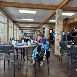
Beautiful outdoor area that allows for swimming, hiking, SUP, picnic areas and beer/food trucks. This park has all the right things and outdoor bathrooms. read more
2 years ago
8 years ago
The water is always nice at Mead's Quarry Lake. Enjoy fantastic scenic views while paddleboarding across the clear blue water. Paddleboard and kayak rentals are available. This beautiful park includes hiking trails, overlooks, woodlands, and a lake observation deck perfect for watching the sunset by the water. Small update: The lake observation pier has been removed due to repetitive vandalism. read more

4 years ago
7 years ago
7 years ago
More info about Mead's Quarry Park
Ask the Community - Mead's Quarry Park
Review Highlights - Mead's Quarry Park


Mead's Quarry Park - lakes - Updated June 2026
Best of Knoxville
People found Mead's Quarry Park by searching for…
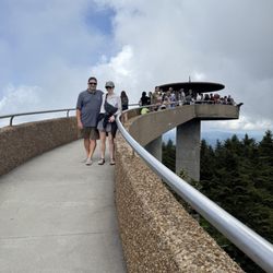
Scenic View in Knoxville, Tennessee
Swimming Holes in Knoxville, Tennessee
Watch Sunset in Knoxville, Tennessee
Swimming Lakes in Knoxville, Tennessee
Secret Spots in Knoxville, Tennessee
Things to Do in Knoxville, Tennessee
Places to Swim in Knoxville, Tennessee
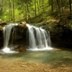
Hiking Trails With Waterfalls in Knoxville, Tennessee
Scenic Overlook in Knoxville, Tennessee
Kayak Rental in Knoxville, Tennessee
Picnic Areas in Knoxville, Tennessee
Rock Quarry in Knoxville, Tennessee
Places to Take Pictures in Knoxville, Tennessee
Scenic Drive in Knoxville, Tennessee
Sunset View in Knoxville, Tennessee
Sunset in Knoxville, Tennessee
Lakes & Ponds in Knoxville, Tennessee
Lookout Points in Knoxville, Tennessee
Off Road Trails in Knoxville, Tennessee
Photo Spots in Knoxville, Tennessee
Beautiful Views in Knoxville, Tennessee
Trending Searches in Knoxville, TN
Boat Launch near Mead's Quarry Park
Boat Rental near Mead's Quarry Park
Cliff Jumping near Mead's Quarry Park
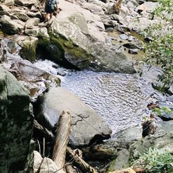
Creeks near Mead's Quarry Park
Day Trips near Mead's Quarry Park
Dog Friendly Trails near Mead's Quarry Park
Fishing Spots near Mead's Quarry Park
Jet Ski Rental near Mead's Quarry Park
Kayak Rental near Mead's Quarry Park
Lakes & Ponds near Mead's Quarry Park
Off Road Trails near Mead's Quarry Park
Outdoor Activities near Mead's Quarry Park
Outdoor Basketball Courts near Mead's Quarry Park
Pick Your Own Farms near Mead's Quarry Park
Picnic Areas near Mead's Quarry Park
Public Shower near Mead's Quarry Park
River Swimming near Mead's Quarry Park
River Tubing near Mead's Quarry Park
Rock Quarry near Mead's Quarry Park
Running Trails near Mead's Quarry Park
Scenic Night View near Mead's Quarry Park
Scenic Overlook near Mead's Quarry Park
Scenic Restaurants near Mead's Quarry Park
Secluded Spots near Mead's Quarry Park
Soccer Store near Mead's Quarry Park
Splash Pad near Mead's Quarry Park
Strawberry Picking near Mead's Quarry Park
Sunrise View near Mead's Quarry Park
Swimming Holes near Mead's Quarry Park
Swimming Lakes near Mead's Quarry Park
Volleyball Courts near Mead's Quarry Park
Watch Sunset near Mead's Quarry Park
Water Parks near Mead's Quarry Park
Browse Nearby
BEST of Knoxville, Tennessee Restaurants near Mead's Quarry Park
BEST of Knoxville, Tennessee Coffee near Mead's Quarry Park
BEST of Knoxville, Tennessee Things to Do near Mead's Quarry Park
BEST of Knoxville, Tennessee Breakfast near Mead's Quarry Park
BEST of Knoxville, Tennessee Shopping near Mead's Quarry Park
BEST of Knoxville, Tennessee Thrift Stores near Mead's Quarry Park
Browse Brands
Related Searches in Knoxville, TN
Affordable Kayak Rental Services in Knoxville, Tennessee
Affordable Paddle Board Rental in Knoxville, Tennessee
Best Fishing Locations and Guides in Knoxville, Tennessee
Best Nature Trails for Hiking in Knoxville, Tennessee
Best Places for Horseback Riding in Knoxville, Tennessee
Check Out Off Road Trails in Knoxville, Tennessee
Discover Dog Friendly Trails to Explore in Knoxville, Tennessee
Discover Lakes & Ponds to Explore in Knoxville, Tennessee
Discover Scenic Mountain Bike Trails Near Knoxville, Tennessee
Discover Scenic Waterfall Spots in Knoxville, Tennessee
Discover Top State Parks to Visit in Knoxville, Tennessee
Discover Walking Parks in Knoxville, Tennessee Near You
Discover a Hiking Trail in Knoxville, Tennessee
Discover the Best Beaches in Knoxville, Tennessee
Discover the Best Fishing Lake in Knoxville, Tennessee
Discover the Best Night Hike Trails in Knoxville, Tennessee
Discover the Best Running Track in Knoxville, Tennessee
Dog-Friendly Hikes With Dogs in Knoxville, Tennessee
Enjoy Camping Adventures Around Knoxville, Tennessee
Enjoy Exciting Mountain Biking Adventures in Knoxville, Tennessee
Enjoy Kayaking Adventures in Knoxville, Tennessee
Enjoy River Tubing Adventures in Knoxville, Tennessee
Enjoy Tent Camping Spots Around Knoxville, Tennessee
Enjoy a Beautiful Waterfall Hike in Knoxville, Tennessee
Enjoy the Best Tubing Experiences in Knoxville, Tennessee
Enjoy the Best Walking Trails in Knoxville, Tennessee
Exciting Cliff Jumping Spots in Knoxville, Tennessee
Experience Thrilling White Water Rafting in Knoxville, Tennessee
Explore Beautiful Parks and Green Spaces in Knoxville, Tennessee
Explore Boat Rentals for Every Need in Knoxville, Tennessee
Explore Easy Hikes Perfect for All in Knoxville, Tennessee
Explore Fun Activities to Do in Knoxville, Tennessee
Explore Parks With Lakes to Visit in Knoxville, Tennessee
Explore Popular Campgrounds Near Knoxville, Tennessee
Explore Popular Picnic Areas Around Knoxville, Tennessee
Explore Popular RV Parks Around Knoxville, Tennessee
Explore Popular Scenic Views Near Knoxville, Tennessee
Explore Secret Spots Worth Visiting in Knoxville, Tennessee
Explore Top Dog Parks in Knoxville, Tennessee Near You
Explore Top Marinas Near Knoxville, Tennessee
Explore Top Water Parks in Knoxville, Tennessee Today
Explore the Best Boating Spots in Knoxville, Tennessee
Explore the Best Swimming Holes Around Knoxville, Tennessee
Explore the Best Trail Options in Knoxville, Tennessee
Find Beautiful Views in Knoxville, Tennessee
Find Cozy Camping Cabins in Knoxville, Tennessee
Find Popular Ziplining Spots Around Knoxville, Tennessee
Find Top Dog Friendly Parks to Visit in Knoxville, Tennessee