
Murphy Ranch Trail Photos


You might also consider
More like Murphy Ranch Trail
Recommended Reviews - Murphy Ranch Trail
Start your review...

Reviews With Photos

An easy to medium difficulty trail set behind a beautiful neighborhood. Parking is not possible at the trail head although some cars are allowed on the dirt road if you have a way of opening the gate (not sure how to get this but saw a few Jeeps drive past me during the way in and out). Today I was hiking but I ended up seeing more mountain bikers. There are two routes you can go, the easy way and the hard way. The easy way is taking the stairs down and then looping back on the paved road entering "the ranch" after. Whereas if you end with the stairs there are over 500 of them and they have shifted a lot over the years so watch your footing. At the bottom of the canyon are a few abandoned buildings and water towers covered in graffiti, and a small creek. I saw many dogs and children on the hike so I would classify this as easy; possibly medium when it's warm. Bringing water isn't needed unless you go during the warm months. A beautiful way to spend the day!

Very cool hike especially if you like history. The buildings are part of a compound built in the 1930s by Nazi sympathizers that included a water tower, fuel tank, bomb shelter, etc. Murphy Ranch was designed as a stronghold for Third Reich supporters waiting for America to fall to the Nazis. In 1941, the ranch was raided by US authorities and shut down. In the 60s and 70s, the buildings were transformed into an artists' colony and later abandoned after the Mandeville Canyon Fire in 1978. DIRECTIONS: First of all, make sure you plug the Pacific Palisades location into your GPS. For some reason, it defaults to a Whittier trail which is not this hike. It'll take you to a dirt road where you can't proceed. Park on the street. I had no problem finding parking although it did add a little bit to the total distance. Once you walk up the dirt road, you will pass a yellow gate, and eventually see a fence on the left. Start looking for a break in the fence, it's easy to miss. You will then see a concrete staircase. Take that down and it'll lead you past the Nazi buildings. It's a loop so you'll emerge back on the same road eventually. We messed up and missed the hole in the fence so we did it backwards and had to climb up the stairs. This is fine if you want an additional workout (in that case, keep walking until you see an obvious trail on your left, past the fence). Anyway, I highly recommend this hike. It's scenic, historical, and fun. Plus, who knows how long these structures will remain standing.

This is a beautiful trail for Sunday hike and the best part of it, it is not busy at all. It is pet friendly as well, so you can bring your animal companions with you. Bring lots of water and snack and prepare yourself to enjoy nice hike. Just a little note, Google Map will take you to the road where you are not meant to park, so find neighborhood street parking, but be respectful, and do not be loud. :)

Its a pretty fun hike, I just think there are better hikes out there like Solstice Canyon, Los Liones, Cave of Munits, Portuguese Bend Trail, etc. It's located in the palisades and isn't a super difficult hike. You park on Casales road, hike the Sullivan fire road, and descend about 500 steps. It's the heavily graffitied ruins of an old Nazi sympathizer compound. It's dog friendly and you will see a ton of people biking the trail. Very gramable with a lot of history and street art.

This is one of my favorite hikes. So much to see and a story behind the scenes. A great place to hike, sightsee and take pictures. There are still remnants of buildings left, a water tower and walls with lots of graffiti This place was designed to have Nazi activity. . It had a water storage tank, a fuel tank, a bomb shelter, bunkers and outbuildings.It was abandoned by 1990. Being at Murphy's Ranch seems surreal. It's one of those places you can imagine all the activity going on at one time based on the remnants that are left A great hike and a definite must see
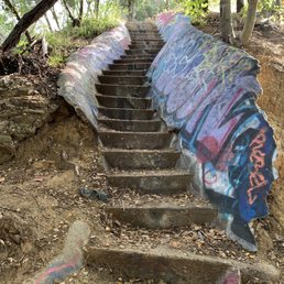

I hiked this trail with a group and it was a lot of fun. It's a 3.4 mile moderate hike so not too difficult. It is located in pacific palisades. What makes this trail so amazing is the fact that it has structures from and old 1930's Nazi campground. You get to see remainders of that and now they are all covered in graffiti and colorful artwork that makes them cool to look at. There's plenty of photo opportunities and it's like walking into another world. It's not a popular trail so you don't see a lot of people. It's also a dog friendly trail so you can definitely bring your dogs. One of the highlights of this hike is the fact that there's like 800 steps you walk up and down from so it gives you a good workout. Beats the stair master that's for sure.

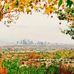
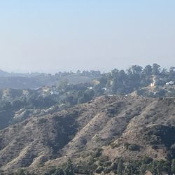
There are three types of people who find themselves on Murphy Ranch Trail: 1) Hikers, 2) Dog walkers, and 3) Adventure seekers. For the first two groups, the hike is not super hard and offers beautiful views of the mountains and ocean. It's breath taking. If you're the third category, you're probably here to explore the graffiti covered Murphy Ranch, a former Nazi compound. In the 1930s, members of a white supremacist group started to create a campus to live off of until Hitler conquered the USA. They'd then help him set up rule in the USA...or so they planned. Obviously, that never happened (thank God!) and it was left deserted. Now you can take a massive staircase (or several) down to explore several homes, a water plant, etc. Don't be alarmed. You'll run into a few others, but we found everyone harmless, just other adventure seekers.

There are several ways to get to this area. My favorite way (long and difficult by my standards) is to start at Will Rogers State Historic Park, hike up to Topanga Canyon and then drop down to the Murphy Canyon/Abandoned Nazi bunker. Over the years it has been fenced off and I can certainly see why, seems very dicey walking into any of the buildings on the property. But it is fascinating, whatever the history turns out to be. I take photos each time and then may my way back to Will Rogers via Rustic Canyon which I think is one of the riskiest, scariest hikes ever. I would have gotten lost more than one if the trail had not been marked with tape. Often times I was up to my knees in water and mud. Honestly I would not recommend this route unless you've been on "Naked and Afraid". But overall a very interesting hike.

This trail is cool because it's got a nice natural view of green mountains and graffiti. Okay, hear me out. I don't like graffiti as much as the next guy. Thankfully most of our trails in LA aren't too sprayed up. This place though it seems like they seemed to allow it, or turn a blind eye? I'll just summarize with bullet points to make it easier to read. - There a stairway of 512 stairs. It's awesome. - There is a broken truck it's also graffiti. - There's green mountains. - We saw a snake, see my picture. - Coop graffiti house and water tank. If you got a dog it loves this part. - Oh, and there is nice bits of shade too. Overall, I'd say it's got lots of gimmicks to go along with the nature to make it interesting. Don't tell your friends about this place. It might turn into Runyon once people catch on.

very interesting place and you do have to hike, and I mean hike, especially, if you go down those 500 steps. 500 steps to go down and explore the area and 500 steps back up so that's 1000 steps. I was extremely tired after coming back up the stairs.. however, it is cool exploring the ruin and abandoned building. Great place for cardio

This is pretty much equivalent to stairmaster. Parking here might be confusing since the directions ARE confusing, but just make sure to park on the street and then you will approach a gate where you can begin the hike. It's a bit long and then you will need to find a bunch of stairs that will can climb down. It's very scenic, and when you climb DOWN the stairs, you will be able to walk and find this little house (picture attached.) I hear the picture or graffiti changes often, as last time it was a pig, but my friend came back and the graffiti changed! Also note that to get back up you also need to climb the stairs. I thought there could be another way up (or an easier way) so make sure to plan ahead on timing so it's not too dark when going back up the stairs!

I accidentally found this trail. I intended on going to the Rustic Canyon Trail but somehow after missing a turn, my GPS took me up a winding hill through a beautiful neighborhood in the Palisades. Although I'd seen pictures of this particular trail and noticed that it was one of the closest ones to me I always went to others e.g. Escondido, Temescal, Solstice etc. to explore. This is an interesting trail with a history that I'm sure you'll read in other reviews. I don't want to give the wrong story about what it was built for. I heard 2 different stories of the history of this place. I felt like Chicago Jones instead of Indiana as I walked through the ruins of the trail. There's a lot of graffiti on the path and although some of it is cool, I wasn't a fan of the empty spray cans and paint on the natural surfaces e.g. trees, rocks and sides of cliffs. The juxtaposition of nature and man-made structures was cool in that in the future when people look back at a place like this they'll hear its origin story and see the graffiti (hieroglyphics) and be able to interpret the messages that people left. The trail is cool and the only reason I didn't take the stairs is because I wanted to stay on the path to prevent from getting lost. Since I went solo and had no idea what was in store I figured for my safety and lack of cell phone service it was better to explore but stay on the trail. Next time I go I will try to enter from another entrance so that I can try the stairs and maybe see things that I may have missed. All in all I would suggest this place as a moderately difficult trail. There's still a lot that I want to see so I'll be returning. There are some cool views of the ocean and with all of the buildings some cool photo opps. If you get a chance check it out.

We took a little walk on the wild side to Murphy Ranch. This areas has a lot of history as was suspected to be a hide out for those individuals who sympathize with Nazis. The ranch was later raided after the bombing of Pearl Harbor. Afterwards became a place for artists and then the buildings were deserted and left to rot away. Give that these buildings draw people who like to party and graffiti, some of the structures have been destroyed. As you can see from the pictures there are still some structures that draw people in. Beyond these buildings there are some gorgeous views on the four mile loop. The loop consist of views of the mountains and a stream that is sometimes dry. Note the trail has a lot of steps: and they are short and narrow. The area not only draws hikers but a lot of mountain bikers. Hikers be careful on the trails as many bikers were not using bells. Lastly, there is not parking at the trailhead. You have to walk in about a half mile to trailhead. Available parking is limited as most areas say do not park. read more


An easy to medium difficulty trail set behind a beautiful neighborhood. Parking is not possible at the trail head although some cars are allowed on the dirt road if you have a way of opening the gate (not sure how to get this but saw a few Jeeps drive past me during the way in and out). Today I was hiking but I ended up seeing more mountain bikers. There are two routes you can go, the easy way and the hard way. The easy way is taking the stairs down and then looping back on the paved road entering "the ranch" after. Whereas if you end with the stairs there are over 500 of them and they have shifted a lot over the years so watch your footing. At the bottom of the canyon are a few abandoned buildings and water towers covered in graffiti, and a small creek. I saw many dogs and children on the hike so I would classify this as easy; possibly medium when it's warm. Bringing water isn't needed unless you go during the warm months. A beautiful way to spend the day! read more


Very cool hike especially if you like history. The buildings are part of a compound built in the 1930s by Nazi sympathizers that included a water tower, fuel tank, bomb shelter, etc. Murphy Ranch was designed as a stronghold for Third Reich supporters waiting for America to fall to the Nazis. In 1941, the ranch was raided by US authorities and shut down. In the 60s and 70s, the buildings were transformed into an artists' colony and later abandoned after the Mandeville Canyon Fire in 1978. DIRECTIONS: First of all, make sure you plug the Pacific Palisades location into your GPS. For some reason, it defaults to a Whittier trail which is not this hike. It'll take you to a dirt road where you can't proceed. Park on the street. I had no problem finding parking although it did add a little bit to the total distance. Once you walk up the dirt road, you will pass a yellow gate, and eventually see a fence on the left. Start looking for a break in the fence, it's easy to miss. You will then see a concrete staircase. Take that down and it'll lead you past the Nazi buildings. It's a loop so you'll emerge back on the same road eventually. We messed up and missed the hole in the fence so we did it backwards and had to climb up the stairs. This is fine if you want an additional workout (in that case, keep walking until you see an obvious trail on your left, past the fence). Anyway, I highly recommend this hike. It's scenic, historical, and fun. Plus, who knows how long these structures will remain standing. read more

This is a beautiful trail for Sunday hike and the best part of it, it is not busy at all. It is pet friendly as well, so you can bring your animal companions with you. Bring lots of water and snack and prepare yourself to enjoy nice hike. Just a little note, Google Map will take you to the road where you are not meant to park, so find neighborhood street parking, but be respectful, and do not be loud. :) read more


7 years ago
Its a pretty fun hike, I just think there are better hikes out there like Solstice Canyon, Los Liones, Cave of Munits, Portuguese Bend Trail, etc. It's located in the palisades and isn't a super difficult hike. You park on Casales road, hike the Sullivan fire road, and descend about 500 steps. It's the heavily graffitied ruins of an old Nazi sympathizer compound. It's dog friendly and you will see a ton of people biking the trail. Very gramable with a lot of history and street art. read more


5 years ago
This is one of my favorite hikes. So much to see and a story behind the scenes. A great place to hike, sightsee and take pictures. There are still remnants of buildings left, a water tower and walls with lots of graffiti This place was designed to have Nazi activity. . It had a water storage tank, a fuel tank, a bomb shelter, bunkers and outbuildings.It was abandoned by 1990. Being at Murphy's Ranch seems surreal. It's one of those places you can imagine all the activity going on at one time based on the remnants that are left A great hike and a definite must see read more


7 years ago
I hiked this trail with a group and it was a lot of fun. It's a 3.4 mile moderate hike so not too difficult. It is located in pacific palisades. What makes this trail so amazing is the fact that it has structures from and old 1930's Nazi campground. You get to see remainders of that and now they are all covered in graffiti and colorful artwork that makes them cool to look at. There's plenty of photo opportunities and it's like walking into another world. It's not a popular trail so you don't see a lot of people. It's also a dog friendly trail so you can definitely bring your dogs. One of the highlights of this hike is the fact that there's like 800 steps you walk up and down from so it gives you a good workout. Beats the stair master that's for sure. read more


There are three types of people who find themselves on Murphy Ranch Trail: 1) Hikers, 2) Dog walkers, and 3) Adventure seekers. For the first two groups, the hike is not super hard and offers beautiful views of the mountains and ocean. It's breath taking. If you're the third category, you're probably here to explore the graffiti covered Murphy Ranch, a former Nazi compound. In the 1930s, members of a white supremacist group started to create a campus to live off of until Hitler conquered the USA. They'd then help him set up rule in the USA...or so they planned. Obviously, that never happened (thank God!) and it was left deserted. Now you can take a massive staircase (or several) down to explore several homes, a water plant, etc. Don't be alarmed. You'll run into a few others, but we found everyone harmless, just other adventure seekers. read more


There are several ways to get to this area. My favorite way (long and difficult by my standards) is to start at Will Rogers State Historic Park, hike up to Topanga Canyon and then drop down to the Murphy Canyon/Abandoned Nazi bunker. Over the years it has been fenced off and I can certainly see why, seems very dicey walking into any of the buildings on the property. But it is fascinating, whatever the history turns out to be. I take photos each time and then may my way back to Will Rogers via Rustic Canyon which I think is one of the riskiest, scariest hikes ever. I would have gotten lost more than one if the trail had not been marked with tape. Often times I was up to my knees in water and mud. Honestly I would not recommend this route unless you've been on "Naked and Afraid". But overall a very interesting hike. read more


This trail is cool because it's got a nice natural view of green mountains and graffiti. Okay, hear me out. I don't like graffiti as much as the next guy. Thankfully most of our trails in LA aren't too sprayed up. This place though it seems like they seemed to allow it, or turn a blind eye? I'll just summarize with bullet points to make it easier to read. - There a stairway of 512 stairs. It's awesome. - There is a broken truck it's also graffiti. - There's green mountains. - We saw a snake, see my picture. - Coop graffiti house and water tank. If you got a dog it loves this part. - Oh, and there is nice bits of shade too. Overall, I'd say it's got lots of gimmicks to go along with the nature to make it interesting. Don't tell your friends about this place. It might turn into Runyon once people catch on. read more


very interesting place and you do have to hike, and I mean hike, especially, if you go down those 500 steps. 500 steps to go down and explore the area and 500 steps back up so that's 1000 steps. I was extremely tired after coming back up the stairs.. however, it is cool exploring the ruin and abandoned building. Great place for cardio read more


This is pretty much equivalent to stairmaster. Parking here might be confusing since the directions ARE confusing, but just make sure to park on the street and then you will approach a gate where you can begin the hike. It's a bit long and then you will need to find a bunch of stairs that will can climb down. It's very scenic, and when you climb DOWN the stairs, you will be able to walk and find this little house (picture attached.) I hear the picture or graffiti changes often, as last time it was a pig, but my friend came back and the graffiti changed! Also note that to get back up you also need to climb the stairs. I thought there could be another way up (or an easier way) so make sure to plan ahead on timing so it's not too dark when going back up the stairs! read more

I accidentally found this trail. I intended on going to the Rustic Canyon Trail but somehow after missing a turn, my GPS took me up a winding hill through a beautiful neighborhood in the Palisades. Although I'd seen pictures of this particular trail and noticed that it was one of the closest ones to me I always went to others e.g. Escondido, Temescal, Solstice etc. to explore. This is an interesting trail with a history that I'm sure you'll read in other reviews. I don't want to give the wrong story about what it was built for. I heard 2 different stories of the history of this place. I felt like Chicago Jones instead of Indiana as I walked through the ruins of the trail. There's a lot of graffiti on the path and although some of it is cool, I wasn't a fan of the empty spray cans and paint on the natural surfaces e.g. trees, rocks and sides of cliffs. The juxtaposition of nature and man-made structures was cool in that in the future when people look back at a place like this they'll hear its origin story and see the graffiti (hieroglyphics) and be able to interpret the messages that people left. The trail is cool and the only reason I didn't take the stairs is because I wanted to stay on the path to prevent from getting lost. Since I went solo and had no idea what was in store I figured for my safety and lack of cell phone service it was better to explore but stay on the trail. Next time I go I will try to enter from another entrance so that I can try the stairs and maybe see things that I may have missed. All in all I would suggest this place as a moderately difficult trail. There's still a lot that I want to see so I'll be returning. There are some cool views of the ocean and with all of the buildings some cool photo opps. If you get a chance check it out. read more


9 years ago
Wow super unique hike, nice change from just the regular scenery. Distance-3.85 miles Elevation change - 325 feet Free at pacific palisades Free parking but watch signs Go any direction on the path and you will be led to some abandoned ruins. Tons of graffiti. Great workout for thighs and butt- so many stairs. The stairs are uneven and different sizes at times. Some stuff has been closed and taken down but still worth the hike. read more


An abandoned Nazi compound? In Los Angeles? I had to see it to believe it. We spent 4.5 hours (~9 miles) exploring all the trails and back routes that Murphy Ranch had to offer. This hike welcomes dogs, children, and families alike. Do a little background check; my friend and I were fascinated that this place even exists! A peaceful hike that represents a very different time in history, Murphy Ranch is more than meets the eye. The trailhead is cozied away in the corner of an affluent neighborhood. Put "Capri Dr and Casale Rd" into your GPS, and park on the right of Casale Rd; the trailhead is to your left, but it's a no parking zone. Once you pass the yellow gate, keep an eye out for a break in the chain link fence. This is the entrance to Murphy Ranch, and also where you will meet the StairMaster of your nightmares (perfect for HIIT). Keep left on the trail to see abandoned buildings that showcase the hidden talents of Los Angeles' lesser known artists. Further down, there is an old stable; it is falling apart and there are bees and asbestos inside, so enter at your own risk! With the exception of the stable, all of the buildings have been boarded up. NOTE: the wrought iron gate from previous reviews no longer exists! Trust me, I looked! I wonder how long the remnants of Murphy Ranch will stand before succumbing to the elements or the ever-present threat of demolition. Hike this piece of history while you can! 6/summersteepventures read more


7 years ago
I really enjoyed this hike. We did the full loop; went down the stairs by the water tower and then walked to meet the fire road and back up again. Took us about 1 hour and 40 minutes. The old refuge is pretty cool to see. What I enjoyed most about the hike is that it was more downhill than up and it worked a totally different set of muscles. If you don't want to climb the stairs back up, it is easy to follow the trail till you hit the fire road. Parking was easy in the neighborhood surrounding streets. Lastly, the view from the highest point before the stairs is pretty beautiful! Cannot wait to go again. read more


Explore this old 1930's Nazi compound nestled in a beautiful Pacific Palisades neighborhood. Fun Facts: Intended to be capable of self-sustain for long periods of time. Has a water storage tank, bomb shelter and a fuel tank. Estimated about 4 million dollars to build - that's a lot for the 1930's! It is on the corner of Capri Drive and Casale Road. It's a bit tricky to find, but if you search "Murphy's Ranch" on Google Maps you should be good. Once you park you go up Sullivan Ridge Fire Road and to your left you will see a chained fence that you can go through. Then a narrow stairway down to the abandoned structures. It is a pretty gnarly stairway. Pretty steep and narrow. Once you get down there, the abandoned buildings are open to look inside. Colorful graffiti line the buildings and makes for great photos. 3 stars because a lot of the time you find stoners and people just getting drunk and ruining it for everyone. Either way still a great place to see... before they tear it down. :( read more


A group of 5 adventurous explorers went on a journey that was full of oooooooohs and ahhhhhs to explore the remnants of the Murphy Ranch Trail. History: Murphy Ranch is a ranch built in Rustic Canyon, Los Angeles in the 1930s by Winona and Norman Stephens, who were sympathizers of the Silver Legion of America. The owner of record in 1933 was Jessie M. Murphy. Designed as a base for Nazi activities in the U.S., it was intended to be capable of being self-sustaining for long periods. The compound had a water storage tank, a fuel tank, a bomb shelter, and various outbuildings and bunkers. The estate's main gate was designed by Paul Williams, a well-known African-American architect in the Southern California area. On Monday, December 8, 1941, the day after the Japanese attack on Pearl Harbor, local police occupied the compound and detained members of the 50-strong caretaker force. * Bumped into some forest rangers and they told us that this place wasn't a nazi compound. Don't know who to believe! Oh wells... the hiking experience goes on! Best location: Capri Drive and Casale Road. Directions on yelp will lead you short of the hiking location by a mile. Parking: There's a small street on the left before Casale St. You can park down the hill. You can also park on Casale St. also. At the intersection, find parking on the right side. Trail head: At Capri Drive and Casale Road, walk left (on Casale Rd) through the residential area until you get to a yellow gate. That's the trail head. Hike: You have three options to do this hike: Option 1 and 2 involves hiking down staircases to the power house. The first one is shorter than the 2nd. Option 3: Keep going on the fire road until you see a fancy looking black gate on the left. You will make a big loop where you'll be able to see all the structures. Once you get to the powerhouse, you can keep on going up till you get to the main road and go right until you see the staircases to the left and walk up those sucksers all 450+ steep steps. Once you're at the top, go right and you're home free!! *As for us, we didn't see those two staircase entrances and did option 3 instead. Reaction: Loved everything about the hike and will definitely hike the trail again. read more


Another great piece of history are being demolished! Before I go off into the history of the trail - (Although other reviews already covered quite well) & my opinion of it w/review, I'm sad to report since the time I went two weekends ago (1/23/16) and from what I'm reading in reviews and tips since then, the old graffitied buildings are being about to be torn down!!! READ 2 Recent links w/explanations: http://lahikes.la/2016/01/24/murphy-ranch-demolition-date/ http://www.modernhiker.com/2016/01/27/help-save-murphy-ranch-from-demolition/ If your still interested in checking it out before it's completely demolished, go with caution and aware that the rangers will be out there and continue to keep people out, cite people tagging, etc. Completion of demolition - February 23, 2016. I'll finish my review soon. But it was pretty fricken awesome!!! read more


11 years ago
I've hiked this place twice already and it's awesome. It's tricky to find. The first time I did this, luckily the people around me knew and all I had to do was ask. Fortunately, I was able to find this the second time on my own. Here's my guide: 1. Use the address to get you in the general area of the hike. You'll be arriving in a nice residential area. I parked on Almalfi. They're doing construction there, so make sure you read signs. Parking is at least abundant here...unike Runyon haha. 2. Walk towards the construction and make a left on Casale from Capri and walk left and around to what looks like a road with a yellow gate. The gate has a sign on it that says CAMP JOSEPHO. Just walk around it. And no, you're not trespassing haha. 3. Follow this trail around the mountain and enjoy the view. You'll start seeing a fence along the left side of the road. When you reach a sign that has graffiti, there will an opening to the fence that leads down to stairs. 4. Make your way down the stairs. Watch your step because the steps are small and sometimes dirt/sand are on the steps making them slippery. Enjoy the way down because up is going to be a workout later! 5. Once you reach the bottom of the stairs, the only way to go is left. 6. Once you reach a fork in the road, take a left towards the graffiti wall. 7. Make another left at the next fork. This left will take you to the bottom of the Camp, but the right leads you to a place where you can hop up to the roof. You can access the roof once you're on the ground level, so I preferred starting there as I have done both ways. Enjoy this place. It's really cool and a hidden gem of la. People come and add their tags all the time. It's not the cleanest, so be prepared for that. Have fun exploring and hopefully my directions helped!!(: read more


If you're looking for a nice short and easy hike, this would be the trail for you. It is a total of approximately 4 miles round trip with an elevation of 600 feet, pavement is relatively flat and easy to handle. As you arrive, park around Capri Drive and Casale Road. Then walk up to Sullivan Ridge Fire Road and keep walking forward until you reach a yellow road block latch. If you see this, you're definitely going the right way. About 100 yds from here, keep your eyes open to the left. You will see a gap in the chain link fence that will lead to what appears to be an "endless" looking staircase ahead. Be careful, the steps are rather narrow so watch out for your foot placement. When you're at the bottom of the steps, remember to turn left and follow the wide road down to the bottom of the Rustic Canyon. You will finally reach a large power house building covered in graffiti. Take your time to soak in this unique robust house and take out your phone to snap away some instagram-worthy photos! Keep in mind, there's a total of 4 structures so make sure to see them all - the power house, water tank, some barn looking building and an old run down machine shed! Happy hiking everyone! read more


I did this hike once in January and again in February. It was a great experience both times. Parking- free, I parked on Casale & Capri both times and it is a short walk to the trailhead Trail- paved fire road uphill for almost 1.5 miles and then you walk down to the compound/property Sights- a truck on the side of the hill about half way up the hike (very easy to miss); fancy iron entrance gate (demolished by our 2nd visit); structures with heavy, colorful graffiti (barn, water tank, etc...); steep stairs with graffiti that give you some amazing views of this beautiful area *not sure what remains, I heard it was all being demolished and the entrance gate and water tower were knocked down on our 2nd visit read more


I've wanted to go to this place for a few years, since I read an article about it in LA Weekly. I read on Yelp that they might demolish this place, so I wanted to see Murphy Ranch because the history behind it it's so interesting- Nazi compound, then an artist colony around '68, it burned down in the 80's. My kinda hike, with a purpose, looking to see something cool, makes the effort and the exercise seem not a big deal. Thanks to my fellow Yelpers for the useful directions and tips, you need them when you go this place, better do your homework ahead of time. Parked on Capri Dr., Camp Josepho was easy to find, continued on the main trail for Rustic Canyon. When you walk on it, you'll see on your left the 500 steps down. As other people said, you can continue on and avoid it -another entrance at the gates, but it's better to do a circle to see everything. We took the 500 steps down, it wasn't bad at all. I'm a weekend type of hiker and it wasn't a big deal going down, the steps aren't steeps, you don't get a vertigo, there's a metal rail to hold on. I don't know if there are 500 steps, but it's not bad at all. We continued down and got to the various ruins, main house, etc. On the way, our group got bigger and bigger (in the beginning it was just me and my husband). This is the most social hike I've ever done. Everyone is friendly, you can stop and chat with fellow hikers, exchange info, I'd recommend that. With all my research, I didn't read anything about the stables, but somebody in our group knew, so we continued on to the right, on a small path to the stables, which are cool to see. Then we got to the water tank and the gates. Moderate hike, beautiful area, cool ruins, worth seeing, they're full of graffiti, there were artists painting while we were there. We returned on the main trail on Rustic Canyon back to the cute neighborhood and Capri Dr. It was a nice day, so the vistas were great, we saw the Ocean and Catalina Island from up there. Check this place out before they'll tear it down. Great exercise, cool LA history, off the beaten path hike and great vistas. And social interaction! read more


Hiked to this area on Sunday 5/26/13. Exited 405 on Sunset, went west. Drove for about 10 minutes (beware of windy curves on Sunset) . Right after Allenford I turned right on Capri. Went straight up till it ended at Casale. Right on Casale, parked. I shouldn't say this, but I will, at the risk of this hiking spot becoming overcrowded. There was hardly a soul hiking this morning, so it echoes the sentiments of the other reviewers. I like less crowded hiking trails. Who needs to listen to how some dude was hitting on your girl at the bar last night? Proceed west..ish...on Casale. Houses, houses, nice houses, and then a dirt road with a sign that says "Camp Josepho". Turn that way (To the left...which is the only way you can turn...) and start walking. Paved road. Very shaded in the morning time. Quiet trail. Then you'll see a chain link fence to your left. Despite the warnings in other reviews, we passed the first set of stairs. We went into the second gap in the chain link fence and went down that set of stairs. I didn't count the steps but it seemed like it was never ending. Finally got to the bottom, and went left. Eventually we found the abandoned compound. We didn't take all the stairs back up, but we did go up a set of stairs (and part of a slope) that was near the latter part of the compound. Steep, intense, great workout. We were looking for the gate that I'd seen in Yelp photos, so we followed the paved road to our left and kept going. At one point, it splits off. We took the trail to the right (more paved road) and VOILA! The gate. We took advantage of the photo opportunity and I made my friends climb the gate. The trail to the gate ends up circumnavigating around the rest of the stairs, so we missed the killer climb back up :) At least part of it. Coming out from the gate, we went to the right, heading back towards Casale. We passed a few people on the way back, several cars, and some bicyclists. Overall, it wasn't too hard of a trail, relatively easy. I could have gone longer and made the hike longer but my natives were hungry so we walked back to the car. Hike: difficulty: easy length: short time: less than 2 hours, and that's because we kept stopping to take photos :) read more


I heard the city is going to close down this area and build a park so I had to check it out ASAP! Drove all the way from OC. I took advice from what others said about directions. Just put into your smart phone Capri and Casale road. Upon arrival, keep walking to this sign that says "no Parking allowed" and it seems confusing but keep walking. Eventually you'll see a yellow gate that says Camp Josepho. proceed through and you'll get to a fork in the road. I stayed left at that fork. you could also take the stairs and make it a leg day but no thank you. There were people filming & graffiting the place, it was sick. read more

 - Hiking Near Me")
My favorite trail on the PCH is Los Liones. LL is just down the street from here. So it was a huge surprise when I found out about this trail from a friend. We were all trippin out that this had been here since the 30s and not once did we hear about until now. We read a bunch of blogs and everyone mentioned that there were a bunch of signs indicating that they were planning on tearing it down at the end of the month. So of course we had to check it out for ourselves. We made the mistake of starting off late. We got there at 12:30 which was basically the peak of the heat. Big no no. Parking - per Google maps, you will basically end up in the residential area at the beginning of the trail. You're allowed to park there, unless of course there's a sign saying you can't. There's a ton of construction happening so they block off certain areas. If you can find a spot then you're golden. You basically follow the street which leads to more of the residential area. Once you see the yellow gate, you cross over and follow it down. There are no signs after. We actually took a wrong turn and ended up going towards the Will Rogers area. Luckily, we had signal and only had to backtrack for about 1/4 of a mile. The way we were suppose to take was where all the trucks are filled with bricks which was what they had already tore down from the property. It's all downhill from there. You just follow the trail that ends at the main house of the property. From there you're free to venture and look about. The whole place was so eerie. The whole property is covered with graffiti, most of which are fresh. And because people are the worst, there are a bunch of empty water bottles, cans, trash, and basically whatever people brought in and decided to leave. This is why we can't have nice things. I definitely recommend going before it's all gone. read more


8 years ago
Trailhead is basically on back of a residential area with No parking signs. So be prepared to park way down the street and add about a mile to your hike. Once you're on trail and off the fire road, you are able to admire the scenery of the Santa Monica mountains. About a mile in, you'll run into some steps 525 to be exact, you can avoid those and keep on heading straight ahead. We decided to take the challenge.! Overall a pretty Easy-peasy hike with lots of history, and I'm not going to lie, it also felt a little creepy to be there. read more


11 years ago
Murphy Ranch Trail has been on my "To-Hike" list for quite some time and I was finally able to check it off this past weekend. This hike is moderate in level of difficulty and has awesome structures to explore along the way. For my group, the hike was approximately 4.5 miles round trip but you can definitely make it more or less depending of your energy and curiosity levels. What I especially liked about this hike is the amount of shade provided along the trails and the nice ocean breeze on the way back up. Bring a camera, bring water, and enjoy this unique hike. read more


5 years ago
Love this trail. Definitely hidden. It was beautiful, we went on a weekday and it wasn't crowded whatsoever. It is long. Depending on how far you want to go. I was in search of the stair way, little did I know that it literally was a little after as we entered the yellow gates to your left. I went all the way upto Camp Josepho. It has breath taking views with a lot of bunnies and birds read more

9 years ago
This may be one hell of a confusing hike for newcomers, but honestly just don't stray away from the main path... if you do follow the graffiti's instructions. For starters, parallel park in the neighborhood; it is 0.5 miles away from the trail head. GPS will guide you to the trail start where there will be no parking. Walk towards the gps area (dirt trail) and you will see a yellow gate. Pass the yellow gate and keep following the path all the way down. You have 2 solid options: 1. Theres graffiti on the ground that says "murphy ranch"and an arrow pointing through some gateway. This will lead u to hundreds of stairs. Go down that, take your first right, go ahead a good amount until you see a sign that says "shortcut". Go down more stairs until you see a water drum. You will be in the main part of Murphys Ranch. Take a right from there to go to the barn and back out to your car. 2. Go all the way down the road until you see the second graffiti'd sign that says murphy's ranch. It will still be a large road. Just keep following that road and it will lead you to the barn. Keep following that pathway to get to the main part of Murphy's ranch. Just a precaution. Although I went into the barn it is closed off and a good amount of time the park rangers will come by and kick you out. They may ticket you (they didn't ticket us). But if you guys still don't care about my warning, be careful on the 2nd floor. The floor is weak and you may fall through if you're not careful. The main part of murphy's ranch is closed up as well but it is still beautiful. Great hike and easy for all ages (as long as you don't stray off the main path) read more


Murphy Ranch has been on my bucket list for years because of it's Nazi sympathizer/WWII history. I'm glad I was able to visit a few weeks ago because it's currently in the process of being torn down. =( There are two ways to go about your adventures to the power house, water tank, and whatever else remains. You can take the nice and easy paved road for a few miles, constantly wondering when you're supposed to turn in (which is when the giant gate eventually greets you). Or, you can take the first gate on the left that has a "park closed..." sign, and climb down the steps that appear to lead you to your death (trust me on this, take these down, not up from the ruins). From the giant gate path, you'll see what remains of the water tower. Then eventually you'll end up at the power house. The house itself is something quite eerie. Maybe it was the things set out for it, or the constant spray paint fumes I was inhaling... But chills. If you take the stairs o'death down, the neat stuff will be to your right from the bottom. I didn't get a chance to look for the barn, or the car. The car is still there however, if you're keen on hopping a fence. read more


8 years ago
My girlfriend and I accidentally drove up the hike, DO NOT MAKE THE SAME MISTAKE!!!! Find parking on the street. The hike itself is pretty intense, only IF you're feeling on the adventurous side and decide to take the mountain path. Tuck your pants into your socks if you don't want any lizards crawling up your leg LOL. Also, wear a hat and long sleeve shirt for extra protection against branches/bees/flys/and all other crazy Shit that flys here. BEWARE OF SNAKES. You will see a couple of them if you take the mountain path. All in all, AMAZING EXPERIENCE! Well worth the hike !! Good luck read more

Pretty cool experience. I'm not a big hiker, so I don't have much to compare it to. But as a person that doesn't exercise much, this hike was pretty do-able. About 4miles...a TON of stairs that go pretty steep but probably just scarier than it is tiring going down. Our group took a detour to avoid the stairs going up and went sight seeing instead. Pretty cool to see the Nazi refuge. A lot of creepy compartments and stuff. The shacks were pretty run down.. the adventurous ones can go climb some ladders up the shacks onto the roofs. There was a shack that looked like it used to be a stable for horses...It was a bit scary as half of it was caving in and some rooms that were pitch dark in broad daylight. On the route back, we saw that someone had left a tire swing on a tree. How they did it beats me... but definitely the cherry on top to this hike! Overall, it was nice to visit once, but not sure if it's worth a 2nd visit. read more


This hike was pretty fun! I went with my girls and we actually found the place pretty quickly. We parked in the neighborhood on the right next to the construction site and walked down to the other end. Just make sure to read the yelp reviews before you get lost!! After we found the yellow gate, I knew we were on the right track. It took a while before getting to this gate door opening on your left. You won't miss it. Also, there was another set of stairs hiding in the bushes before that but we missed it and ended up going to the ones with the gate door opening. It turned out to be right! There should be a few sets of stairs before you actually get to the bottom. But that's not the end! At the end of the stairs you'll turn left and then another left. It will lead you to the ranch. My girls and I spent a few hours just relaxing and taking pictures. It's nice to do something exciting. Plus it was really fun to chill on the roof. Make sure to go on it! Someone left a 'surprise' graffiti there. It's hilarious. You'll see when you go on top of the roof ;) Anyways, the way back up was the most tiring part! Those stairs though.. Haha I was lowkey dying (not really) but I had to stop a few times to breathe. Overall, a fun & cool hike. It's easy & kinda short! read more


Page 1 of 8
More info about Murphy Ranch Trail
Los Angeles, CA 90272
Pacific Palisades
Directions
Hours
Indoor Amenities
Outdoor Amenities
Ask the Community - Murphy Ranch Trail
Is there any wild life ? I wanna experience this trail but my gf is scared we might see animals or get hurt
Hi Jasmin! No, you and your girlfriend will be completely safe. No danger at all. Even if you do see any small animal, just respect their home and enjoy the nature. Get there early, bring water and snacks and don't leave anything behind. Have an…
What's a good time to start this hike? Is 8am too early?
Yes, it is good to start hiking. Anytime during daylight is good. Trail has a long stairs. I recommend you should wear tennis shoes or any flat shoes.
Are dogs allowed?
Yes, dogs are allowed on leash. Past reviewers on Yelp have mentioned dogs were allowed, as well as these two separate write-ups on the trail: https://www.alltrails.com/trail/us/california/murphy-ranch-trail--2…
I don't get too many weekends off, and I want to hike here before more structures are taken down. Is this trail safe for solo hike on WEEKDAYS? I'm hoping to see other hikers on the trails in case I have problem looking for structures/get lost.
It's pretty safe overall...many of the structures from what I heard are gone already there are still remnant structures around and what remained of others as well most laden with graffiti nowadays...
Review Highlights - Murphy Ranch Trail
You might also consider


Why does Yelp recommend reviews?
14 reviews that are not currently recommended
The reviews below are not factored into the business's overall star rating.
13 years ago
11 years ago
6 years ago
11 years ago
11 years ago
10 years ago
4 years ago
12 years ago
11 years ago
12 years ago
11 years ago
Murphy Ranch Trail - hiking - Updated July 2026
Best of Los Angeles
People found Murphy Ranch Trail by searching for…
Abandoned Buildings in Los Angeles, CA
Dog Friendly Beaches in Los Angeles, CA
Hiking Trails in Los Angeles, CA
Abandoned Places in Los Angeles, CA
Waterfall Hike in Los Angeles, CA
Attractions in Los Angeles, CA
Lookout Points in Los Angeles, CA
Urban Exploration in Los Angeles, CA
Campgrounds in Los Angeles, CA
Kids Friendly Beaches in Los Angeles, CA
Hiking Groups in Los Angeles, CA
Secret Spots in Los Angeles, CA
Stair Climbing in Los Angeles, CA
Off Leash Dog Hikes in Los Angeles, CA
Night Hiking in Los Angeles, CA
Free Campgrounds in Los Angeles, CA
Hiking Trails Kid Friendly in Los Angeles, CA
Beautiful Views in Los Angeles, CA
Shaded Hike in Los Angeles, CA
Trending Searches in Los Angeles, CA
Blueberry Picking near Murphy Ranch Trail
Cliff Jumping near Murphy Ranch Trail
Day Trips near Murphy Ranch Trail
Dog Friendly Beaches near Murphy Ranch Trail
Dog Friendly Trails near Murphy Ranch Trail
Jet Ski Rental near Murphy Ranch Trail
Kayak Rental near Murphy Ranch Trail
Off Road Trails near Murphy Ranch Trail
Outdoor Activities near Murphy Ranch Trail
Peach Picking near Murphy Ranch Trail
Places To Swim near Murphy Ranch Trail
Places To Walk Around near Murphy Ranch Trail
Pool Day Pass near Murphy Ranch Trail
Public Shower near Murphy Ranch Trail
River Swimming near Murphy Ranch Trail
River Tubing near Murphy Ranch Trail
Rock Quarry near Murphy Ranch Trail
Scenic Night View near Murphy Ranch Trail
Scenic Overlook near Murphy Ranch Trail
Secluded Spots near Murphy Ranch Trail
Soccer Store near Murphy Ranch Trail
Sunrise View near Murphy Ranch Trail
Swimming Holes near Murphy Ranch Trail
Swimming Lakes near Murphy Ranch Trail
U Pick Farms near Murphy Ranch Trail
Browse Articles
Browse Nearby
BEST of Los Angeles, California Coffee near Murphy Ranch Trail
BEST of Los Angeles, California Restaurants near Murphy Ranch Trail
BEST of Los Angeles, California Things to Do near Murphy Ranch Trail
BEST of Los Angeles, California Breakfast near Murphy Ranch Trail
BEST of Los Angeles, California Walking Trails near Murphy Ranch Trail
BEST of Los Angeles, California Parks near Murphy Ranch Trail
BEST of Los Angeles, California Campgrounds near Murphy Ranch Trail
BEST of Los Angeles, California Taxis near Murphy Ranch Trail
BEST of Los Angeles, California Hot Springs near Murphy Ranch Trail
Browse Brands
Related Searches in Los Angeles, CA
Best Dog Hiking Trails Around Los Angeles, California
Best Fishing Locations and Guides in Los Angeles, California
Best Nature Trails for Hiking in Los Angeles, California
Best Places for Horseback Riding in Los Angeles, California
Check Out Off Road Trails in Los Angeles, California
Discover Dog Friendly Trails to Explore in Los Angeles, California
Discover Easy Hiking Trails Near Los Angeles, California
Discover Kid Friendly Hiking Trails in Los Angeles, California
Discover Popular Bike Trails in Los Angeles, California
Discover Scenic Mountain Bike Trails Near Los Angeles, California
Discover Walking Parks in Los Angeles, California Near You
Discover a Hiking Trail in Los Angeles, California
Discover the Best Night Hike Trails in Los Angeles, California
Dog-Friendly Hikes With Dogs in Los Angeles, California
Enjoy Camping Adventures Around Los Angeles, California
Enjoy Kayaking Adventures in Los Angeles, California
Enjoy Off Leash Dog Hikes in Los Angeles, California
Enjoy Scenic Places to Walk in Los Angeles, California
Enjoy Tent Camping Spots Around Los Angeles, California
Enjoy a Beautiful Waterfall Hike in Los Angeles, California
Enjoy the Best Walking Path in Los Angeles, California
Enjoy the Best Walking Trails in Los Angeles, California
Explore Beautiful Parks and Green Spaces in Los Angeles, California
Explore Easy Hikes Perfect for All in Los Angeles, California
Explore Fun Activities to Do in Los Angeles, California
Explore Popular Campgrounds Near Los Angeles, California
Explore Popular Dog Walking Trails in Los Angeles, California
Explore Top Dog Parks in Los Angeles, California Near You
Explore the Best Beach Spots in Los Angeles, California
Family Friendly Hiking With Kids in Los Angeles, California
Find Parks and Recreation Activities in Los Angeles, California
Find Top Dog Friendly Parks to Visit in Los Angeles, California
Find Top-Rated Waterfalls in Los Angeles, California Now
Find the Best Parks for Picnics in Los Angeles, California
Hiking Trails With Waterfalls in Los Angeles, California
Off Leash Dog Hiking Trails in Los Angeles, California
Popular Outdoor Activities to Try in Los Angeles, California
Popular Picnic Spots to Visit in Los Angeles, California
Popular Waterfall Hiking Trails in Los Angeles, California
Safe River Swimming Areas in Los Angeles, California
Safe and Fun Parks for Kids in Los Angeles, California
Top Hiking Trails to Explore in Los Angeles, California
Top Playgrounds for Kids to Enjoy in Los Angeles, California
Top Running Trails to Explore in Los Angeles, California
Top Swimming Lakes to Enjoy in Los Angeles, California
Top Swimming Spots and Pools in Los Angeles, California
Top-Rated Camping Sites in Los Angeles, California
Walk Dog Friendly Hiking Trails in Los Angeles, California
Walk the Best Paved Walking Trails in Los Angeles, California
People who viewed Murphy Ranch Trail also viewed
Bee Rock
25 reviews
Griffith Park
Musch Trail - Topanga State Park
22 reviews
Santa Ynez Falls - Topanga State Park
56 reviews
Pacific Palisades
Mount Hollywood
18 reviews
Griffith Park
Sandstone Peak
15 reviews
Topanga State Park
8 reviews
Brentwood
Tuna Canyon Park
77 reviews
Temescal canyon Trail
10 reviews
Pacific Palisades
Baldwin Hills Scenic Overlook
1129 reviews
Charlie Turner's Trail
39 reviews
Griffith Park