Cancel

    Open app

    Search

    Oregon Dunes Overlook and Day Use Area

    5.0 (2 reviews)
    Open 6:00 am - 10:00 pm

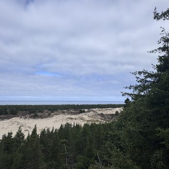
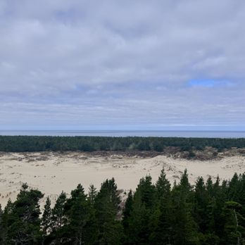
    Oregon Dunes Overlook and Day Use Area Photos

    More like Oregon Dunes Overlook and Day Use Area

    Recommended Reviews - Oregon Dunes Overlook and Day Use Area

    Your trust is our priority, so businesses can't pay to alter or remove their reviews. Learn more about reviews.
    Yelp app icon
    Browse more easily on the app
    Review Feed Illustration

    6 months ago

    Helpful 7
    Thanks 1
    Love this 6
    Oh no 0

    14 days ago

    Helpful 1
    Thanks 0
    Love this 0
    Oh no 0

    Verify this business for free

    People searched for Hiking 112 times last month within 15 miles of this business.

    Verify this business

    Sweet creek trail - Bridges to pass.

    Sweet creek trail

    4.9(27 reviews)
    19.8 mi

    Many waterfalls and swimming holes along this amazing and shaded trail…read more Love mossy rocks? How about lush ferns? How do you feel about cascading water? Do you enjoy dipping your feet into cold water on a hot summer day? Or how about swimming among giant redwood trees? If any of this sounds appealing you need to visit Sweet Creek Falls. We came in the middle of summer and it was the perfect way to spend an afternoon hiking, meditating, and swimming. There are 11 waterfalls ranging in size and close to 2.5 miles all together of shaded trails to explore, rustic bridges included. This was definitely one of the highlights of our trip to Oregon last summer. Know before you go: Parking lots at each trailhead. Super stinky bathroom located only at Homestead Trailhead. Dog friendly. And most importantly FREE! *Don't be surprised to see topless women swimming. We all have breasts and it's a beautiful thing to be free especially in a place like this. If this bothers you just look away. *Don't use Yelp directions as they'll take you to the wrong place. Use Google instead. I've reported this several times but like nearly everything I report Yelp ignores it. And Happy Earth Day! If you haven't discovered what nature can do for your soul I highly recommend getting away from the daily grind, turning your phone off, and just enjoying what places like this can do for you. It's truly magical.

    Awesome trail with multiple waterfalls. Trails were nice and clear of debris and branches. A few…read morespots with bigger rocks, roots, and water. Gorgeous scenery! There are so many photo opportunities. Many different bridges along the trail allow you to walk over the water. There is a part of the trail where you have to walk through a small stream. I wasn't wearing the proper gear and didn't want wet shoes and socks, so we headed back at that point and headed towards the upper parking lot. The upper trail still had snow on the ground, and the parking area was pretty soggy. Overall, we thoroughly enjoyed our time here. We would love to come back again during a drier season. Highly recommend!

    Photos
    Sweet creek trail - Cascading water along the trail.

    Cascading water along the trail.

    Sweet creek trail - Just a happy banana slug.

    Just a happy banana slug.

    Sweet creek trail - Perfect summer afternoon as most of the trail is shaded.

    See all

    Perfect summer afternoon as most of the trail is shaded.

    Golden and Silver Falls State Natural Area

    Golden and Silver Falls State Natural Area

    4.1(7 reviews)
    26.3 mi

    The waterfalls are flowing!! I haven't been since summer 2019 and I was amazed by the volume…read moredifference. Both trails are fairly flat. If you're not with small children I would definitely recommend the upper trail. There's steep drop offs at the top which could be dangerous.

    After reading reviews, we were hesitant to take the drive to these falls. There was mention of 8…read moremiles of gravel road with potholes that leads to the trail heads. But go we did. Turns out it is 5 miles of gravel road with the aforementioned potholes. Very slow going and dusty. It took over an hour to drive from Coos Bay. Which would have been okay if the falls were overly impressive which unfortunately they weren't. It has been very dry so there was very little water in the falls. There are massive rocks that the falls trickle over. If you want to get a little closer to the falls you will need to climb over fallen rocks. The trails need maintenance as the brush is intruding and parts of the trail are crumbling away. The area has a jungle like feeling with all the trees, ferns and other greenery. There are three trails. One to Silver Falls, one to the bottom of Golden Falls, and one closer to the tops of the falls. We hiked all three and it took about 1 1/2 hours. There are restrooms at the trail head, and an information stand. Personally, I would skip it unless the falls were full of water. Not worth getting the car dirty and challenging the suspension!

    Photos
    Golden and Silver Falls State Natural Area
    Golden and Silver Falls State Natural Area - Golden Falls

    Golden Falls

    Golden and Silver Falls State Natural Area

    See all

    804 Trail - Surprisingly lots of blooms along the trail even in August!! (2025)

    804 Trail

    4.9(18 reviews)
    34.1 mi

    This is a great trail along the ocean in Yachats. It begins in a neighborhood and takes you down to…read morethe beach where you can see tidepools. There are a few benches along the trail where you can sit and relax and take in the gorgeous ocean view. It's most popular in the mornings, for tidepools, and evenings, for beautiful sunsets. The trail is pretty flat and expands about 2 miles. It connects to a couple of other trails in Yachats to the south, the Oregon Coast Trail (1 mile) and the Amanda Trail (1 mile). The trails are well maintained and perfect for a casual walk to take in the fresh ocean air. I would highly recommend!

    I've returned to this magnificent trail so many times over the years - my review is long overdue…read morebut it's kind of a hidden gem and I'm hoping it'll stay that way lol! This is probably my #1 fave trail of all time. It's not technically difficult by any means - it's short, almost entirely flat, and very well maintained. But it holds my heart bc there's a veritable feast for my lens in every nook and cranny and the environment changes year after year due to storms, tides, and sand levels rising and falling - a never ending photographer's paradise! And no doubt I'll be returning year after year for a long time. The trail runs about 1.5 miles from the sleepy coastal town of Yachats to its dead-end on a long sandy beach in the Cape Perpetua protected marine area. To say the tide pools here are amazing is an understatement. They are unparalleled! I've never seen so many colorful starfish, anemones, snails, barnacles, and tons of other undersea creepy crawlers anywhere else. The sunset and sunrise views are magical as well. And there are interesting pockets and tunnels created by mysterious wind swept coastal pines - just glorious! The giant dark basalt boulders are covered in so many species of barnacles and always changing shape due to erosion from wind and waves - creating so many fascinating pools to explore. The trail meanders past my fave hotel of all time too - the Overleaf Lodge. This is my happy place - my heart is always here. If you ever have the chance to visit, take it.

    Photos
    804 Trail - This rock was covered in hundreds of anemones! The tide pools along the trail are incredible to say the least!

    This rock was covered in hundreds of anemones! The tide pools along the trail are incredible to say the least!

    804 Trail - Goose barnacles surrounding the anemones! The tide pools along the trail are incredible to say the least!

    Goose barnacles surrounding the anemones! The tide pools along the trail are incredible to say the least!

    804 Trail - Views from the trail as the tide comes in

    See all

    Views from the trail as the tide comes in

    Devil's Churn

    Devil's Churn

    4.7(26 reviews)
    31.2 mi

    Devils Churn is one of the coolest geological formations I've ever seen…read more As the tide comes in, the waves are concentrated in the basalt chasm (the result of an ancient collapsed lava tube), where they gain speed, ricochet against themselves, creating the "churn" look. It looks like a giant ocean bathtub full of violent butter. The waves splash dozens of feet in the air, filling tide pools on the basalt cliffs, and then cascading back down over the edges in a circular formation of infinite waterfalls. It looks like something you would imagine you would see in Iceland. The churn can be seen from a viewing area close to the parking lot, but it's just a short half mile hike down to the shore. Even though people have been washed out to sea from this site, these people had gone beyond the official trail, into the actual tide pool area above the churn. So, as long as you're on the trail, you're probably safe. I held on to the wooden rail just in case a big wave came, but noticed that the very bottom rung had been washed out. There is enough parking for about twenty cars at the information center, which is staffed by the Forest Service on limited hours/days. Parking is $5 or free with an NPS, Forest Service, or other federal interagency pass. I've actually been here a few times now. Valentine's Day was pretty crowded, and the visitor center was open. I had to leave before high tide, but was mesmerized. So, I ended up coming back during high tide a few days later. At one point, I saw the ocean throw an entire tree onto the ledge-- only to reclaim it a few minutes later. Falling in to the churn would almost certainly result in death. Some of the waves looked like they were going 25mph once they entered the chasm. Plus it's full of huge logs being violently churned around. But just half mile down the trail, there is a calm, serene beach with really pretty rocks. Continuing on, you can actually hike to Thors Well from here. I can't believe I'd never even heard of this place until I stumbled upon it by accident after visiting Thors Well. Personally I actually found the churn more impressive and mesmerizing to watch.

    Super easy hike down to devils churn with accessible parking. I would highly recommend checking to…read moresee where the tide is at before going down for your safety. Came here with my friend on our way to Florence .

    Photos
    Devil's Churn - The pathway leading towards Devils Churn.

    The pathway leading towards Devils Churn.

    Devil's Churn - Info about Devils Churn day use.

    Info about Devils Churn day use.

    Devil's Churn

    See all

    Oregon Dunes Overlook and Day Use Area - hiking - Updated August 2026
    Loading...
    Loading...
    Loading...