1. Oxbow River Snorkeling

    1. Oxbow River Snorkeling

    0

    ,

    Oxbow River Snorkeling

    5.0 (1 review)
    Open 9:00 am - 5:00 pm

    Oxbow River Snorkeling Photos
    Recommended Reviews - Oxbow River Snorkeling

    Your trust is our priority, so businesses can't pay to alter or remove their reviews. Learn more about reviews.
    Yelp app icon
    Browse more easily on the app
    Review Feed Illustration

    8 years ago

    Helpful 0
    Thanks 0
    Love this 1
    Oh no 0

    Ask the Community - Oxbow River Snorkeling

    Verify this business for free

    Get access to customer & competitor insights.

    Verify this business

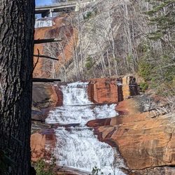
    Toxaway Falls - Very cool

    Toxaway Falls

    3.3(4 reviews)
    0.9 km

    Very cool but a bit hard to find. GPS takes you to the road above. We had to find a better view…read morethrough some unmarked roads. Good luck

    I truly find it unbelievable that I can come into an area and wrack up so many FTR's (first to…read morereview) locations. Am I seriously the only yelper who hikes in North Carolina? I'm even more surprised this particular waterfall had no Yelp page! It has a commanding presence that you absolutely cannot miss AND no hike is required to view it, so you would think SOMEONE would have yelped it by now. TOXAWAY FALLS is a gigantic roadside waterfall downstream of the Toxaway Lake Dam. Nearly the entire waterfall is surrounded by either CRAZY STEEP terrain or private property and the only way to really get a head-on shot of the falls is by drone or helicopter! There is a pull-off east of the bridge that give you a decent side view, but doesn't show the depth of the falls like a frontal view would! You can also visit nearby Toxaway Cafe for lunch and an incredible, but distant side view of the falls. It's the best frontal view you're gonna get unless you happen to rent one of the nearby homes facing the falls. While Toxaway Falls looks more like an enormous water slide, topography maps show the falls begin at around 2,953 feet just below the bridge and the overall terrain drops to an elevation of 2,658 in just under a quarter of a mile for a total decline of 295 feet. The main fall drops 80 feet, from 2,920 feet to 2,840 into a pool of water then continues to cascade over significant drops for the next 1,000 feet (about 3.33 football fields). *** [ THINGS TO KNOW ] Total Hiking Distance: 0 miles (roadside) Difficulty: Easy (viewing platform) Creek Crossings: NO Elevation Gain: 0 feet Waterfall Height: about 90 feet initial drop and over 275 total with cascades. Waterfall source: Toxaway River WATERFALL ATTRACTIVENESS - 7 out of 10 TRAIL ATTRACTIVENESS - n/a Access to top of falls: YES Access to base of falls: NOT REALLY Pool of water @ base of Falls: YES Sitting areas @ base: YES if it were accessible RESTROOM FACILITIES: NO PARKING: YES (space for about 8-10 cars) *** [ FINAL THOUGHTS ] TOXAWAY FALLS is a wonder to behold. MASSIVE in size, but difficult to view in all its glory. Still a worthy stop if you happen to be passing through Hogback, NC on Hwy 64. IF you want to see its true size, click on the link below for a drone video of the falls. ENJOY! Drone video: https://www.youtube.com/watch?v=AW-Bj7jSUv0 2021 / 59

    Photos
    Toxaway Falls - Peaking through the tail for a glimpse of Toxaway Falls

    Peaking through the tail for a glimpse of Toxaway Falls

    Toxaway Falls - As viewed from the bridge. How lucky are those homeowners on the distant mountain facing the falls?!

    As viewed from the bridge. How lucky are those homeowners on the distant mountain facing the falls?!

    Toxaway Falls - As viewed from a small sitting area just below Toxaway Cafe. All other pics taken from opposite side of falls.

    See all

    As viewed from a small sitting area just below Toxaway Cafe. All other pics taken from opposite side of falls.

    Thompson River Waterfalls

    Thompson River Waterfalls

    5.0(2 reviews)
    8.1 km

    IF you want a challenging hike and are looking to score a bunch of amazing waterfalls on the SAME…read moreTRAIL, the Thompson River Waterfalls trail is your Huckleberry!!! Google maps has labeled the trailhead HIGH FALLS TRAIL HEAD just off Whitewater Road. As you turn onto Brewer Road, you will see a wide trail entrance on the corner. We parked along the side of the road near the entrance. There are multiple waterfalls along the trail as Thompson River makes its run down the mountain, dropping approx. 1,900 feet over 5 miles as it makes is way to beautiful Lake Jocassee. There are seven names waterfalls along the trail and 3 that absolutely should not be missed: HIGH FALLS, RICH FALLS & BIG FALLS aka THOMPSON FALLS. THE TRAIL The trail initially ascends about 60 feet but remains at a fairly consistent decline of about 500 feet along the entirety of the main trail. First up was REID FALLS at around .9 miles, but we decided to skip it. A split in the trail at around 1.1 miles leads to HIGH FALLS, a gorgeous 50 foot sliding ribbon waterfall. There really is no way to get an excellent picture of the falls without getting wet. The best vantage of the falls is across the river and a scramble over some large boulders to a beach like area. The pool in front of the falls is better than 6 feet deep, but most of the shallow areas were only ankle or calf deep. Back along the main trail we continued our descent down the mountain and next came to SIMON FALLS, which we also opted to skip. All of the falls (except High Falls) require a scramble downhill to view. Reid and Simon Falls have the least steep scrambles, but we wanted to conserve our legs for Big Falls, the steepest of the scrambles. We also bypassed Rich Falls around the 3.8 mile mark as we decided it would be best to see how we feel after tackling Big Falls. BIG FALLS Listen, however easy the trail seemed up until this point was about to SEVERELY change! The descent to the falls is about 535 feet in less that a quarter of a mile. IT IS VERY STEEP and some areas require sitting on your butt and sliding, other require holding on to low branches or roots and one area in particular requires mild vertical rock climbing. NOT KIDDING! But all of it is doable if you take your time and don't have any serious physical or health challenges. All of the MAIN trail is very easy to follow, but I would highly recommend downloading the ALLTRAILS map because it shows the exact entry points for the side trails to each of the falls. The side trail to Big Falls is easy to follow, but can be very faint in some areas. Once you make it down to the river, look for a side trail just before the final descent to the riverbank. It will lead you through a thicket of vegetation that leads to a boulder entrance to the falls. Navigate them as best you can to get to a great vantage point to view the falls. If you are not skilled at boulder hopping, this area will be very intimidating! But you MUST do it in order to view the Big Falls, which is not visible otherwise. NOTES / TIPS ~ Download ALLTRAILS MAP prior to your drive to the trailhead ~ There are 3 river crossings and yes you will get wet ~ Most of the falls require getting wet for best view ~ No restroom facilities at the trailhead ~ BRING PLENTY OF WATER & SNACKS FINAL THOUGHTS On our return, we were just too exhausted to attempt to see Rich Falls, so instead we used every ounce of energy we had remaining to make it back to the car. I was thoroughly exhausted. The 3.5 miles back seemed more like 10 and we'd run out of drinking water during our time at Big Falls. I recommend a minimum of five 16oz bottles to do this hike and more if you bring salty snacks. I'd also recommend you chug one bottle at the parking area before you begin. All in all this is an amazing trail full of gorgeous waterfalls. Big Falls easily has become one of my top 5 favorite southern waterfalls... but it is a beast of a hike! ALLTRAILS LINK: https://www.alltrails.com/explore/trail/us/north-carolina/thompson-river-waterfalls?mobileMap=false&ref=sidebar-static-map 2023 / 12

    A series of gorgeous waterfalls along beautiful Thompson River as it makes its way from the higher…read moremountain elevations down to the Jocassee River. The trail offers a great experience for anyone at any hiking level. If you are like me and prefer more leisurely hikes, The first three waterfalls (Reid Branch, High Falls & Simon Falls) are fairly easy to reach. High Falls in particular is great for families with small children and has a wading pool of water at its base of different depths. There is even a small beach like area to relax and have a picnic. Just know you must get wet in order to reach the beach area, which also has the best view of the falls since High Falls kind of sits recessed into a little nook making it difficult to see in its entirety. But for those who are more like my husband and don't mind a more difficult hike, Rich Falls and Big Falls further downstream will give you plenty of challenge. Although I must say, my husband was sore several days after his hike and while he thought Big Falls was stunning, he was miserable on the return. He said the side trail to Big Falls was extremely steep and challenging, both on the way down and especially on the climb back out. It drained him completely at age 54 and he still had to endure a 3.5 mile hike back to the car running on empty. Knowing him he'll do it again! MEN... LOL Also near the parking area is a trail leading to White Owl Falls. A very short hike to a beautiful 20 foot waterfall. Walk west on Whitewater Road from the parking area and look for an opening with a pink ribbon tied to a tree branch about 900 feet from the trailhead.

    Photos
    Thompson River Waterfalls - HIGH FALLS on Thompson River is approx. 50 feet tall

    HIGH FALLS on Thompson River is approx. 50 feet tall

    Thompson River Waterfalls - HIGH FALLS on Thompson River is approx. 50 feet tall

    HIGH FALLS on Thompson River is approx. 50 feet tall

    Thompson River Waterfalls

    See all

    Riley Moore Falls

    Riley Moore Falls

    4.2(5 reviews)
    48.9 km

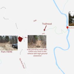
    I just wanted to update my 3/15/20 review below to add I've now done this hike several times, but…read moreTHIS time I had the chance to hike it with a friend who is directly related to the namesake of the waterfall... Riley Moore. Sandie is a church friend of mine and Riley Moore was her Great Great Uncle (I believe that's right). He once upon a time operated a grist mill here at the top of the falls. She's been trying to get here to see the waterfall, but couldn't find it and wanted to join us (along with her family) since I knew the way. Upon further research I discovered there are actually still remnants of the mill including visible drill holes, spikes and bolts. Thought that was pretty cool info to share! [ [ [ PREVIOUS REVIEW ] ] ] Riley Moore Falls is small in height but HUGE in personality. It's located off State Road S37-748, which is a nicely maintained gravel road where cars and trucks alike can comfortably traverse. ~~~ DIRECTIONS From Westminster, SC - DO NOT turn onto Cobb Bridge Road from Long Creek Hwy (Hwy 76) where you will see the brown & white sign pointing you in the direction of Riley Moore Falls. Our GPS had us go this way, then left onto State Road S37-748, but the road was CLOSED during our visit! INSTEAD, turn onto PU-32 also known as Rocky Fork Road. Turn left onto a gravel road near Rocky Fork Baptist Church and follow that until it dead ends @ State Road S37-748 (also known as Spy Rock Road). Turn right and drive approx. 1.4 miles (4 minutes) to 748c (aka Riley Moore Shoals Road). Park at the intersection of State Road S37-748 and 748c. DO NOT ATTEMPT TO DRIVE 748c in a car or minivan. Low clearance vehicles will find the terrain on this road to be VERY difficult to navigate without bottoming out or getting stuck. I'd also recommend 4x4 capability on wet days! There can be several deep-pocketed muddy areas after heavy rains. ~~~ THE TRAIL Once you reach the intersection of Spy Rock Rd (S37-748) and 748c, park roadside on Spy Rock, secure your vehicle and begin your hike approx. 1/2 mile down the "primitive road." IF you have a high ground clearance SUV or truck, you can drive the primitive road another half mile or so to a second parking area near the trailhead. The primitive road is VERY BUMPY  and can be muddy in spots after heavy rains, so a 4x4 is best. After reaching the second parking area, follow the marked trail on the left!!! The trail is a little over a 1/2 mile to the falls from here. The trail is fairly straightforward and easy to follow. ~~~ THE FALLS Once you reach the Chauga River, you will notice a large sandy area with plenty of room for an entire horde of hikers!!! Riley Moore Falls is not very tall (only about 12 feet), but it is very wide and has a deep base pool. PRO TIP - Bring swimwear, towels and a picnic, but be sure to pack it in and pack it out. ~~~ THINGS TO KNOW Hiking Distance: 2 miles (round trip to falls from S37-748) Difficulty of hiking 748c: All downhill to trailhead (moderate return) Difficulty of hiking trail to falls: EASY Creek Crossings: NO Elevation Gain: 357 feet Waterfall Height: Approx 12 feet Access to top of falls: NO - not without getting wet Access to base of falls: YES Pool of water @ base of Falls: YES Sitting areas @ base: YES + sandy beach RESTROOMS: NO PARKING: YES (along road) + secondary parking area closer to trailhead for trucks and high ground clearance vehicles with room for about 6 cars. ~~~ [ FINAL THOUGHTS ] A lovely waterfall in any season, but also a great spot for a summer swim. While we had the waterfall practically to ourselves during our Mid-March expedition, be advised other trail website reviews say it gets trashy & crowded in summer months. What a shame if that is true because it truly is a treasure. ENJOY! 2022 / 74 #UPDATE 178

    Don't know haven't been yet. I cannot tell you something why I have not been seen. So I cannot say…read moreanything about the place

    Photos
    Riley Moore Falls
    Riley Moore Falls - CREATED FROM GOOGLE MAPS

    CREATED FROM GOOGLE MAPS

    Riley Moore Falls

    See all

    Shadow of the Bear

    Shadow of the Bear

    5.0(5 reviews)
    15.2 km

    Amazing to watch the shadow come around and morph into a bear! If you are in the area in mid-late…read moreOctober, make sure you check this out! Bear comes around 5:30 pm but definitely get there early as there is limited parking.

    Are you looking for something to do this fall? Have you ever heard of the "Shadow of the Bear" in…read moreNorth Carolina? This was highlighted in "Our State" magazine, I think last year but I could have saved the article from the year before, but this was one of those items on my "local" bucket list to see. I love the Shadow of the Bear in Cashiers! The "Shadow of the Bear" is visible for 30 minutes daily (on sunny days!) between 5:30-6:15 PM from mid-October through early November as the sun sets behind Whiteside Mountain between Sapphire Valley and Highlands, North Carolina. It's best seen on clear days around 5:30 p.m., with the show lasting for about a half-hour. The photos below are from 2022; I'm pretty sure we'll visit again this year. PS I agree with Ginger L. that the camaraderie with all the people standing on the side of the road to watch is an experience in itself. A note of caution, to view the bear, you park your car on the side of a road hugging the edge of a mountain and people crossing the road that has a curve around the mountain so use caution while driving through the area and walking along the road!!!! But its all worth the view!!!

    Photos
    Shadow of the Bear - Shadow of the Bear at the peek viewing while we were there.

    Shadow of the Bear at the peek viewing while we were there.

    Shadow of the Bear - Shadow of the bear

    Shadow of the bear

    Shadow of the Bear

    See all

    Oxbow River Snorkeling - snorkeling - Updated July 2026
    Loading...
    Loading...
    Loading...