Palisades Park Photos


You might also consider
More like Palisades Park
Recommended Reviews - Palisades Park
Start your review...


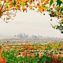
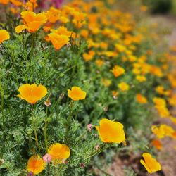
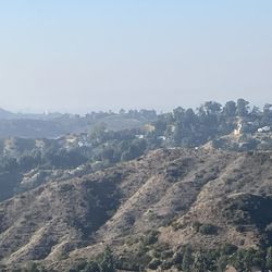
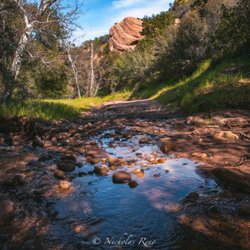
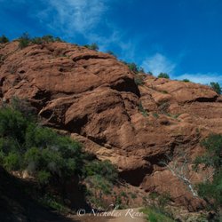
The two things that Porter Ranch is arguably known best for are pretty homes and pretty trails. One of my favorite trails here is at Palisades Park, a 1.6 mile multi-use trail between Tampa Ave and Reseda Blvd. The "park" is essentially a hill right behind a bunch of homes. The trailhead is on Tampa Ave, 400 feet south of Braemore Rd. The trail has light-moderate inclines, but horseback riding and biking are possible. The trail weaves back and forth across the face of the hill, which causes you to notice the scenery. Dried brush and some shrubs cover the hill, but there's really nothing in terms of shade. A wood railing kindly runs along the outer edge of the trail to discourage people from taking a tumble. A couple lookout points offer a nice view of the San Fernando Valley from 500 feet above. Keep your eyes open, and you may even see a jackrabbit or two darting off the trail into the brush. There's plenty of street parking on Tampa and Reseda. I like to park on Reseda and jog to the trailhead on Tampa and back. The inclines make for a great leg workout! Cool fact: Palisades Park had a 10 second appearance 15 minutes into the movie E.T. the Extra-Terrestrial: http://www.yelp.com/biz_photos/palisades-park-los-angeles?select=FquAyFNQMfYxb0QVV9atEg#FquAyFNQMfYxb0QVV9atEg read more


12 years ago
11 years ago
If you're from the area, it's a pretty cool short trail to get on. We started on the Tampa side and ended up on Reseda. The entrances to the trail aren't marked very well so hope my pictures will help. It's a dirt trail and you can see houses but not much shade. There's one part close to the reseda opening that had shade but that's it. Parking isn't allowed on Tampa anymore so turn into Braemore Rd and walk down on Tampa to get to the entrance. Some people reviewed you can ride your bikes but not too sure according to the signs just FYI. read more


8 years ago
Great views all over and nice hiking trails on top and bottom. Bottom trail entrances are on Reseda and Tampa and are horse trails. Great for hiking. read more


11 years ago
One of my favorite spots. i come to this place often, and i come here for the great view. This is also a great place to hang whenever there's a meteor shower at night. Get a blanket and lay in the ground. absolutely breathtaking. read more


8 years ago
9 years ago
10 years ago
More info about Palisades Park
Los Angeles, CA 91326
Porter Ranch
Directions
(818) 756-8060
Call Now
Hours
Outdoor Amenities
Ask the Community - Palisades Park
You might also consider


Palisades Park - hiking - Updated June 2026
Best of Los Angeles
People found Palisades Park by searching for…
Meteor Shower in Los Angeles, California
Hiking Trails in Los Angeles, California
Places to Take Pictures in Los Angeles, California
Parks in Los Angeles, California
Beautiful Views in Los Angeles, California
Lookout Points in Los Angeles, California
Photo Spots in Los Angeles, California
Night View in Los Angeles, California
Running Trails in Los Angeles, California
View Points in Los Angeles, California
Scenic View in Los Angeles, California
Off Road Trails in Los Angeles, California
Star Gazing in Los Angeles, California
Scenic Overlook in Los Angeles, California
Parks for Pictures in Los Angeles, California
Great View Points at Night in Los Angeles, California
Places to Walk at Night in Los Angeles, California
Bike Paths in Los Angeles, California
Walking Trails in Los Angeles, California
Secluded Spots in Los Angeles, California
Shaded Hike in Los Angeles, California
Secret Spots in Los Angeles, California
Trending Searches in Los Angeles, CA
Black Owned Nail Salons near Palisades Park
Boat Rental near Palisades Park
Cliff Jumping near Palisades Park
Dog Friendly Things To Do near Palisades Park
Fishing Spots near Palisades Park
Jet Ski Rental near Palisades Park
Kayak Rental near Palisades Park
Lakes & Ponds near Palisades Park
Outdoor Activities near Palisades Park
Parks For Picnics near Palisades Park
Pick Your Own Farms near Palisades Park
Places To Walk Around near Palisades Park
Public Shower near Palisades Park
River Swimming near Palisades Park
Rock Quarry near Palisades Park
Scenic Night View near Palisades Park
Scenic Overlook near Palisades Park
Secluded Spots near Palisades Park
Soccer Store near Palisades Park
Splash Pad near Palisades Park
Strawberry Picking near Palisades Park
Sunrise View near Palisades Park
Swimming Holes near Palisades Park
Swimming Lakes near Palisades Park
Watch Sunset near Palisades Park
Browse Articles
Browse Nearby
BEST of Los Angeles, California Coffee near Palisades Park
BEST of Los Angeles, California Restaurants near Palisades Park
BEST of Los Angeles, California Things to Do near Palisades Park
BEST of Los Angeles, California Walking Trails near Palisades Park
BEST of Los Angeles, California Parks near Palisades Park
BEST of Los Angeles, California Breakfast near Palisades Park
BEST of Los Angeles, California Campgrounds near Palisades Park
Browse Brands
Related Searches in Los Angeles, CA
Affordable Kayak Rental Services in Los Angeles, California
Best Fishing Locations and Guides in Los Angeles, California
Best Nature Trails for Hiking in Los Angeles, California
Best Places for Horseback Riding in Los Angeles, California
Check Out Off Road Trails in Los Angeles, California
Discover Dog Friendly Trails to Explore in Los Angeles, California
Discover Kid Friendly Hiking Trails in Los Angeles, California
Discover Scenic Hiking Trails in Los Angeles, California
Discover Scenic Mountain Bike Trails Near Los Angeles, California
Discover Scenic Waterfall Spots in Los Angeles, California
Discover Walking Parks in Los Angeles, California Near You
Discover a Hiking Trail in Los Angeles, California
Discover the Best Night Hike Trails in Los Angeles, California
Discover the Best Running Track in Los Angeles, California
Dog-Friendly Hikes With Dogs in Los Angeles, California
Enjoy Camping Adventures Around Los Angeles, California
Enjoy Exciting Mountain Biking Adventures in Los Angeles, California
Enjoy Kayaking Adventures in Los Angeles, California
Enjoy Tent Camping Spots Around Los Angeles, California
Enjoy a Beautiful Waterfall Hike in Los Angeles, California
Enjoy a Peaceful Nature Walk in Los Angeles, California
Enjoy the Best Walking Path in Los Angeles, California
Enjoy the Best Walking Trails in Los Angeles, California
Exciting Cliff Jumping Spots in Los Angeles, California
Explore Beautiful Parks and Green Spaces in Los Angeles, California
Explore Easy Hikes Perfect for All in Los Angeles, California
Explore Fun Activities to Do in Los Angeles, California
Explore Popular Campgrounds Near Los Angeles, California
Explore the Best Beach Spots in Los Angeles, California
Explore the Best Trail Options in Los Angeles, California
Family Friendly Hiking With Kids in Los Angeles, California
Find Beautiful Views in Los Angeles, California
Find the Best Parks for Picnics in Los Angeles, California
Find the Best Scenic View Locations in Los Angeles, California
Great Places to Walk in Los Angeles, California
Hike the Popular Waterfall Trail in Los Angeles, California
Hiking Trails With Waterfalls in Los Angeles, California
Off Leash Dog Hiking Trails in Los Angeles, California
Plan a Scenic Drive Route Near Los Angeles, California
Popular Outdoor Activities to Try in Los Angeles, California
Popular Picnic Spots to Visit in Los Angeles, California
Safe River Swimming Areas in Los Angeles, California
Safe and Fun Parks for Kids in Los Angeles, California
Top Climbing Spots and Gyms in Los Angeles, California
Top Paddleboarding Activities in Los Angeles, California
Top Running Trails to Explore in Los Angeles, California
Top Swimming Lakes to Enjoy in Los Angeles, California
Top Swimming Spots and Pools in Los Angeles, California
Walk Dog Friendly Hiking Trails in Los Angeles, California
Walk the Best Paved Walking Trails in Los Angeles, California
People who viewed Palisades Park also viewed
Mario DeCampos Trail
46 reviews
Granada Hills
The Loop Trail
4 reviews
Granada Hills
Nature Trail
4 reviews
Granada Hills
Michael D. Antonovich Regional Park at Joughin Ranch
6 reviews
Chatsworth
Bee Canyon Park
6 reviews
Granada Hills
Chatsworth Oaks Park
22 reviews
Chatsworth
El Scorpion Canyon Park
14 reviews
Old Stagecoach Road Trail
4 reviews
Chatsworth
Corbin Canyon Park
7 reviews
Woodland Hills
Lookout Trail
5 reviews
Granada Hills