
Ragged Point Scenic View Photos


You might also consider
More like Ragged Point Scenic View
Recommended Reviews - Ragged Point Scenic View
Start your review...

Reviews With Photos

This was a beautiful stop along the pacific coast Highway 1 featuring photo ops and full landscaping everywhere you look. My party and I had a great picnic lunch on the lawn. Parking is a bit limited in the inn/restaurant area but is quick turnaround for spots. There are eclectic items in the gift shop as well. There is a public bathroom (could probably use a cleaning and maintenance) that did it's job.

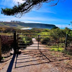
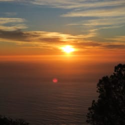
From my interpretation, this Ragged Point Scenic View is the location situated right behind the Ragged Point Inn, a picturesque lodge perched high above the edge of the California Coastline. When I first approached the overlook, there was a sign mentioning that you could take a Nature Trail all the way down to the beach shores. Though, it was so high up at the vista point that I didn't feel like making the trek down to the waters, only to then turn around and make the arduous climb back up the cliffside. I was content with just strolling alongside the fenced-in area of the viewpoint. I took about 20 minutes to casually look about the surroundings and appreciate what appeared to be a never ending stretch of rugged rocks hovering over the Pacific Ocean waters. I will say that a lot of the natural growth of the trees and bushes standing in front of the overlook did hinder the sights and backdrop of the coastline. But I was still able to squeeze myself in between some undisturbed sections to snap a few quality pictures. Also, unfortunately during my visit the skies were mainly overcast with haze and fog, so I never got the most fulfilling photographs. Though, I could sense how the overlook had potential to be very rewarding during sunny days. In general, I'd say this Ragged Point area along Highway 1/Cabrillo Highway is worthwhile for stopping at and taking a break if you're doing the long drive. Another quick note, the Ragged Point Inn appeared to be a quaint and charming place to stay among the wide open outdoors. I had never heard of it prior to showing up unexpectedly, but I would consider this lodge an upscale place to stay for a weekend getaway. Overall, just having an opportunity to take a break from driving the windy and twisty Highway 1 Road, it was refreshing to come here to this Ragged Point Scenic View and acquire another perspective for what makes the California Coast so famous.

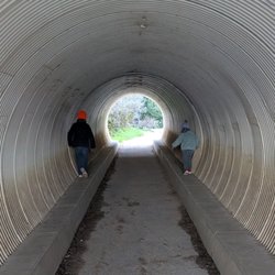
Always a favorite place to stop when I've got to get out there for a Highway 1 fix. Sometimes we'll make the short drive from the San Simeon area just for the views, then head back to where we like to stay in the Cayucos area. Sometimes (sadness) the road washes out about 5 miles north of there, so it's as far as we can drive. Sometimes we'll drive south from Monterey and we'll stop at Ragged Point to stretch our legs and gaze at the amazing shoreline there. There's a (pricey) gas station at Ragged Point, a little store, restrooms, a snack bar, a gift shop, a restaurant, a hotel and scenic walking paths. Lots of flowers. As you walk along the path to the water, you'll see a cool, round wooden lookout spot, that's great for a photo op. On the fence, near the water, people have been placing padlocks through the links. Some are quite interesting. There's a bench there by the padlock fence, too, for ocean watching. As many times as we've stopped there, it's never something I tire of.

Thanks to Yelp pal Hannah S.'s review, I had bookmarked this spot as a place to stop when we were in the area. The views are indeed scenic! We grabbed some coffee at the shop located here and then took a stroll behind the stores to savor the cool breezes, the trees, and the lovely sights of the Pacific Ocean. There's actually a trail, too, but we didn't venture down it as we were pressed for time. This is worth a stop to bask in the beautiful seascape. read more


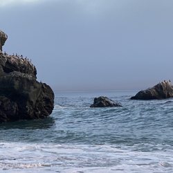
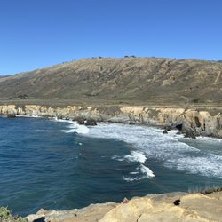
Lovely scenic stop along the PCH as you make your way up from Cambria towards Big Sur. There's a restaurant, gas station, great coffee shop, bathrooms, art work, some hiking and view points, and an inn all at this little stop area. I walked all the way to the back where there's a lovely overlook with expansive Pacific Ocean views all along the cliffs and out as far as the eye can see! I even saw a sea otter hanging out with a sea gull - playing around in the waves together haha!! I think the gull was chasing him and gobbling up the otter's leftovers lol. There's another hiking trail on site down to the black sands of Young Creek Beach - but it's a super steep hike down a 400 foot cliff and I wasn't feeling it lol! But there are lots of nice seating areas overlooking the trail, beaches and cliffs so it's still very enjoyable. I grabbed a coffee and some dessert at the coffee shop instead which I can highly recommend!! It was fantastic and the staff were wonderful (see my review for Ragged Point Coffee Shop & Bakery). At the time of my visit, it was about as far as you could go up the PCH to Big Sur bc the road further up is washed out but they're working on it. Still a great little spot to explore - lots of parking and great views. I'd definitely consider staying at the inn next time! read more


Only one of the best views in California! This is definitely a scenic view that is breathtaking. Every time I come here, I fall in love with California! It's a last stop before heading to Big Sur. Or you can just make the trip - 14 miles north of San Simeon. A short drive that's worth the view! read more


This was a beautiful stop along the pacific coast Highway 1 featuring photo ops and full landscaping everywhere you look. My party and I had a great picnic lunch on the lawn. Parking is a bit limited in the inn/restaurant area but is quick turnaround for spots. There are eclectic items in the gift shop as well. There is a public bathroom (could probably use a cleaning and maintenance) that did it's job. read more


From my interpretation, this Ragged Point Scenic View is the location situated right behind the Ragged Point Inn, a picturesque lodge perched high above the edge of the California Coastline. When I first approached the overlook, there was a sign mentioning that you could take a Nature Trail all the way down to the beach shores. Though, it was so high up at the vista point that I didn't feel like making the trek down to the waters, only to then turn around and make the arduous climb back up the cliffside. I was content with just strolling alongside the fenced-in area of the viewpoint. I took about 20 minutes to casually look about the surroundings and appreciate what appeared to be a never ending stretch of rugged rocks hovering over the Pacific Ocean waters. I will say that a lot of the natural growth of the trees and bushes standing in front of the overlook did hinder the sights and backdrop of the coastline. But I was still able to squeeze myself in between some undisturbed sections to snap a few quality pictures. Also, unfortunately during my visit the skies were mainly overcast with haze and fog, so I never got the most fulfilling photographs. Though, I could sense how the overlook had potential to be very rewarding during sunny days. In general, I'd say this Ragged Point area along Highway 1/Cabrillo Highway is worthwhile for stopping at and taking a break if you're doing the long drive. Another quick note, the Ragged Point Inn appeared to be a quaint and charming place to stay among the wide open outdoors. I had never heard of it prior to showing up unexpectedly, but I would consider this lodge an upscale place to stay for a weekend getaway. Overall, just having an opportunity to take a break from driving the windy and twisty Highway 1 Road, it was refreshing to come here to this Ragged Point Scenic View and acquire another perspective for what makes the California Coast so famous. read more


 from this, the Ragged Point Scenic View. - Hiking Near Me - Ragged Point, California")
2 years ago
1 year ago
4 years ago
Always a favorite place to stop when I've got to get out there for a Highway 1 fix. Sometimes we'll make the short drive from the San Simeon area just for the views, then head back to where we like to stay in the Cayucos area. Sometimes (sadness) the road washes out about 5 miles north of there, so it's as far as we can drive. Sometimes we'll drive south from Monterey and we'll stop at Ragged Point to stretch our legs and gaze at the amazing shoreline there. There's a (pricey) gas station at Ragged Point, a little store, restrooms, a snack bar, a gift shop, a restaurant, a hotel and scenic walking paths. Lots of flowers. As you walk along the path to the water, you'll see a cool, round wooden lookout spot, that's great for a photo op. On the fence, near the water, people have been placing padlocks through the links. Some are quite interesting. There's a bench there by the padlock fence, too, for ocean watching. As many times as we've stopped there, it's never something I tire of. read more


3 years ago


4 years ago
More info about Ragged Point Scenic View
Ask the Community - Ragged Point Scenic View
Review Highlights - Ragged Point Scenic View


Ragged Point Scenic View - hiking - Updated July 2026
Best of Ragged Point
People found Ragged Point Scenic View by searching for…
Things to Do in Ragged Point, CA
Watch Sunset in Ragged Point, CA
Redwood Trees in Ragged Point, CA
Waterfall Hike in Ragged Point, CA
Picnic Spots in Ragged Point, CA
Fishing Spots in Ragged Point, CA
Playgrounds in Ragged Point, CA
Scenic View in Ragged Point, CA
Hiking Trails in Ragged Point, CA
Dog Friendly Hiking Trails in Ragged Point, CA
Parks BBQ Grills in Ragged Point, CA
View Points in Ragged Point, CA
Sand Dunes in Ragged Point, CA
Scenic Drive in Ragged Point, CA
Secret Spots in Ragged Point, CA
Swimming Lakes in Ragged Point, CA
Lookout Points in Ragged Point, CA
Off Road Trails in Ragged Point, CA
Beautiful Views in Ragged Point, CA
Park With BBQ Pits in Ragged Point, CA
Browse Nearby
BEST of Ragged Point, California Restaurants near Ragged Point Scenic View
BEST of Ragged Point, California Coffee near Ragged Point Scenic View
BEST of Ragged Point, California Things to Do near Ragged Point Scenic View
BEST of Ragged Point, California Breakfast near Ragged Point Scenic View
BEST of Ragged Point, California Beaches near Ragged Point Scenic View
BEST of Ragged Point, California Cabins near Ragged Point Scenic View
BEST of Ragged Point, California Horseback Riding near Ragged Point Scenic View
BEST of Ragged Point, California Campgrounds near Ragged Point Scenic View
Browse Brands
Browse Articles
People who viewed Ragged Point Scenic View also viewed
Sand Dollar Beach
31 reviews
Jung Ranch Trail
2 reviews
Limekiln State Park
143 reviews
Shamel Park
33 reviews
Buzzard's Roost Trail
2 reviews
San Simeon Beach
7 reviews
Pacific Valley Bluff Trail
1 review
Salmon Creek Trail
2 reviews
Hiking Trails at San Simeon Bay
6 reviews
San Simeon State Park & Campground
160 reviews