Sakonnet Greenway Trail Photos


You might also consider
More like Sakonnet Greenway Trail
Recommended Reviews - Sakonnet Greenway Trail
Start your review...

10 years ago
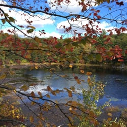
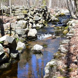
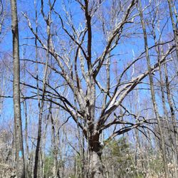
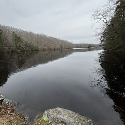
Woods farms and golf The Sakonnet Greenway Trail was finally completed in Oct of 2012 and is over ten miles in length. It actually consists of many different sections that were connected together. It's the longest hiking path in Aquidneck Island but then it's probably the only real hiking trail on the island. The trial is flat and easy in most places and rambles through woods, old farms, marsh land and every along the side of a golf course. Certainly has a lot of varied terrain but nothing difficult or challenging. This is a pleasant and relaxing hike that even gives distant views of the ocean in places. No bikes are allowed on the trail but horses and dogs are welcome as long as they are kept under control, and when there is snow the trail is a great place to cross country ski and snow shoe. The trail has a bunch of trailheads so parking is always available somewhere and is open all year long unless there is a really wet and muddy spring which closes parts of it. A very pleasant and scenic if flat trail to hike on. The most enjoyable thing about the trail is all the different terrains and types of landforms that you go through as you meander along. read more


More info about Sakonnet Greenway Trail
203 Arcadia Rd
Hope Valley, RI 02832
Directions
Hours
Outdoor Amenities
You might also consider


Sakonnet Greenway Trail - hiking - Updated July 2026
Best of Hope Valley
People found Sakonnet Greenway Trail by searching for…
Things to Do in Hope Valley, Rhode Island
Hiking Trails With Waterfalls in Hope Valley, Rhode Island
Walking Trails in Hope Valley, Rhode Island
Scenic Views in Hope Valley, Rhode Island
Bike Paths in Hope Valley, Rhode Island
Running Trails in Hope Valley, Rhode Island
Off Leash Dog Hikes in Hope Valley, Rhode Island
Dog Hiking Trails in Hope Valley, Rhode Island
Night View in Hope Valley, Rhode Island
Easy Hikes in Hope Valley, Rhode Island
Waterfalls in Hope Valley, Rhode Island
Places to Take Pictures in Hope Valley, Rhode Island
Watch Sunset in Hope Valley, Rhode Island
Snow in Hope Valley, Rhode Island
Swimming Holes in Hope Valley, Rhode Island
Swimming Lakes in Hope Valley, Rhode Island
Fitness & Instruction in Hope Valley, Rhode Island
Scenic Drive in Hope Valley, Rhode Island
Dog Friendly Trails in Hope Valley, Rhode Island
Sunrise View in Hope Valley, Rhode Island
Flats in Hope Valley, Rhode Island
Camping & Campsites in Hope Valley, Rhode Island
Trending Searches in Hope Valley, RI
4th Of July Fireworks near Sakonnet Greenway Trail
Black Owned Nail Salons near Sakonnet Greenway Trail
Boat Rental near Sakonnet Greenway Trail
Cliff Jumping near Sakonnet Greenway Trail
Day Trips near Sakonnet Greenway Trail
Fireworks near Sakonnet Greenway Trail
Jet Ski Rental near Sakonnet Greenway Trail
Kayak Rental near Sakonnet Greenway Trail
Lakes & Ponds near Sakonnet Greenway Trail
Off Road Trails near Sakonnet Greenway Trail
Outdoor Activities near Sakonnet Greenway Trail
Parks For Picnics near Sakonnet Greenway Trail
Places To Walk Around near Sakonnet Greenway Trail
Public Pools near Sakonnet Greenway Trail
Public Shower near Sakonnet Greenway Trail
River Swimming near Sakonnet Greenway Trail
Rock Quarry near Sakonnet Greenway Trail
Scenic Overlook near Sakonnet Greenway Trail
Soccer Store near Sakonnet Greenway Trail
Splash Pad near Sakonnet Greenway Trail
Strawberry Picking near Sakonnet Greenway Trail
Sunrise View near Sakonnet Greenway Trail
Swimming Holes near Sakonnet Greenway Trail
Swimming Lakes near Sakonnet Greenway Trail
Watch Sunset near Sakonnet Greenway Trail
Browse Articles
Browse Nearby
Browse Brands
Related Searches in Hope Valley, RI
Best Fishing Locations and Guides in Hope Valley, Rhode Island
Best Fun Things to Do in Hope Valley, Rhode Island
Best Places for Horseback Riding in Hope Valley, Rhode Island
Discover Dog Friendly Beaches Near Hope Valley, Rhode Island
Discover Dog Friendly Trails to Explore in Hope Valley, Rhode Island
Discover Popular Photo Spots in Hope Valley, Rhode Island
Discover Public Beaches to Visit in Hope Valley, Rhode Island
Discover Top Boat Tours in Hope Valley, Rhode Island for All Ages
Discover a Hiking Trail in Hope Valley, Rhode Island
Discover the Best Night Hike Trails in Hope Valley, Rhode Island
Dog-Friendly Hikes With Dogs in Hope Valley, Rhode Island
Enjoy Camping Adventures Around Hope Valley, Rhode Island
Enjoy Kayaking Adventures in Hope Valley, Rhode Island
Enjoy Tent Camping Spots Around Hope Valley, Rhode Island
Enjoy Water Activities and Fun in Hope Valley, Rhode Island
Exciting Cliff Jumping Spots in Hope Valley, Rhode Island
Experience Stunning Sunset Views in Hope Valley, Rhode Island
Explore Beautiful Parks and Green Spaces in Hope Valley, Rhode Island
Explore Easy Hikes Perfect for All in Hope Valley, Rhode Island
Explore Popular Campgrounds Near Hope Valley, Rhode Island
Explore Popular RV Parks Around Hope Valley, Rhode Island
Explore Popular Scenic Overlook Points in Hope Valley, Rhode Island
Explore Scenic Lakes to Visit in Hope Valley, Rhode Island
Explore Secret Spots Worth Visiting in Hope Valley, Rhode Island
Explore Top Dog Parks in Hope Valley, Rhode Island Near You
Explore the Best Beach Spots in Hope Valley, Rhode Island
Explore the Best Boating Spots in Hope Valley, Rhode Island
Explore the Best Swimming Holes Around Hope Valley, Rhode Island
Find Popular Ziplining Spots Around Hope Valley, Rhode Island
Find the Best Parks for Picnics in Hope Valley, Rhode Island
Find the Best Playgrounds to Visit in Hope Valley, Rhode Island
Find the Best Scenic View Locations in Hope Valley, Rhode Island
Hiking Trails With Waterfalls in Hope Valley, Rhode Island
Off Leash Dog Hiking Trails in Hope Valley, Rhode Island
Perfect Spots to Watch Sunset in Hope Valley, Rhode Island
Plan Nature Center Visits in Hope Valley, Rhode Island
Plan a Scenic Drive Route Near Hope Valley, Rhode Island
Popular Kids Activities in Hope Valley, Rhode Island
Popular Picnic Spots to Visit in Hope Valley, Rhode Island
Popular Places to Take Pictures in Hope Valley, Rhode Island
Popular Things to Do in Hope Valley, Rhode Island
Safe and Fun Parks for Kids in Hope Valley, Rhode Island
Top Climbing Spots and Gyms in Hope Valley, Rhode Island
Top Paddleboarding Activities in Hope Valley, Rhode Island
Top Places for Snorkeling in Hope Valley, Rhode Island
Top Playgrounds for Kids to Enjoy in Hope Valley, Rhode Island
Top Running Trails to Explore in Hope Valley, Rhode Island
Top Swimming Lakes to Enjoy in Hope Valley, Rhode Island
Top Things to Do With Kids in Hope Valley, Rhode Island
Walk Dog Friendly Hiking Trails in Hope Valley, Rhode Island
People who viewed Sakonnet Greenway Trail also viewed
Big River Management Area
4 reviews
Frenchtown Park Trail
13 reviews
Whale Rock Trail
11 reviews
Audubon Lathrop Wildlife Refuge
1 review
Osamequin Wildlife Sanctuary
13 reviews
Ben Utter Trail
16 reviews
Duval Trail System
1 review
Great Swamp Management Area
2 reviews
Martin Wildlife Refuge
1 review
John H Chafee Nature Preserve
17 reviews