San Gabriel Peak Photos


You might also consider
More like San Gabriel Peak
Recommended Reviews - San Gabriel Peak
Start your review...

Reviews With Photos

This is a nice short hike. Roughly 3-4 miles round trip from Eaton Saddle trailhead. But you can extend the hike to other peaks like Mount Lowe, Mount Markham, Mount Disappointment or Mount Deception. If you want you can also start at Bill Reilly trailhead. This is a small parking lot past redbox picnic area. Due to the summer weather, I started at Eaton Saddle because the hike will be shorter to be done by noon time. You will first pass thru Mueller Tunnel. Once you arrive at Markham Saddle, you will want to go on the trail on the right. If you go straight, that takes you to the campground and to inspiration point. If you go left, you will see a rusted post sign to Mount Lowe. From here, the trail is pretty straightforward. You will reach a trail split. Go right, that will take you to San Gabriel Peak. The final push is steep but anyone can do it, just take breaks when needed. Eventually you will summit the top and you will see a bench and a register box. It's a nice view of the neighboring peaks. Just head back down, and once you get back to that trail split. If you went to the left trail. That would have taken you to Mount Disappointment. That's the radio tower, which is also what's left of the Nike Missile site. I would recommend knocking this out if your going to do San Gabriel Peak. It's so close by, it will not take much effort to complete this. Once all done, just head back the way you got here. Note, you will need an adventure pass, which you can pick up at REI or like Big 5 Sporting Goods. There is also Poodle Dog Bush on the trail, so be careful to avoid touching when hiking. Also, there were a lot of bugs, luckily I was wearing a long sleeve shirt and pants. But if you hate that, maybe wait till winter time. As always, pack accordingly to the weather and have fun.

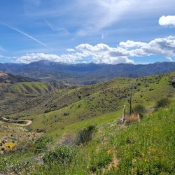
San Gabriel Peak has an elevation of 6,160'. It is easily accessible from the Red Box parking lot or Eaton Canyon Saddle lot. There are loose rocks under foot on the trail. The climb to the peak is not very steep from the fire road. Once on the top, there are nice 360 degree views. This climb can be easily combined with hiking to other peaks for a greater challenge.

Sunday I hike with a friend through red box parking lot to do San Gabriel 5 peaks Circular a total of 13 miles. The wind was wild but we did all 5 peaks. San Gabriel peaks was a moderate hike not the many people and there is bench and have two plaques if you want to take pictures with it The view is ok..... Recommended to do Mt Markham, Mt Disappointment, Mt Deception and Mt Lowe since all are close by and you can do a loop. Look in All trails San Gabriel 5 Peaks Circular and you can download the map. Enjoy the trails and please leave no trace. read more


Fantastic local hike - definitely one of the easier peaks in the area in terms of strenuous level. But if you're afraid of heights (like me) then it's a feat of psychological endurance as well haha! Amazing views follow you almost the entire trail - on clear days you see the whole SGV from multiple spots along the trail, not just the top! The trail is well maintained but has definitely experienced some washout from all these storms. It's extremely narrow with no safety enhancements so take your time and be careful. A lot of the time you're up against the wall of the mountain with sheer drops on the other side of you. It's all very rocky and loose gravel too. I recommend hiking boots with good traction and poles! I don't usually bring my poles but they were a lifesaver on this trail. I was more terrified on this trail than even Angels Landing in Zion so it's definitely not for the faint of heart if you're scared of heights haha! There were patches of snow and ice at the top - I really was wishing for my spikes. It was slippery and scary - and yes, I slid back down on my butt for part of it haha! No shame! The top has amazing views on clear days. The clouds came rolling in right as I made it up so I didn't get to see the valley but the clouds were very dramatic and beautiful- and made it haunting and eerie on the way down. So worth it! There are several places you can start the hike from - I started from the Eaton Saddle trailhead as it's the most straightforward. AllTrails tells you it's 2.8 miles but my tracker read 3.5 miles at the end. You'll gain just over 1030 feet in elevation - half of that elevation gain is in the last half mile so be prepared - it's a great workout and totally doable. If I can do it, you can do it! You pass through Mueller Tunnel pretty early on - it was flooded at the end from all this rain - but if you keep to the right there's some shallow rocks you can cross on to keep dry. After about a mile (maybe less) you'll come to a crossroads - the left takes you to the Mt Lowe trails so keep right for San Gabriel peak. The next crossroads you come to, you'll also keep right. If you go left, you can also summit Mt Disappointment- I skipped it to save my energy but it doesn't add too much - less than a mile I think but several hundred feet in elevation is gained. The top of the peak is just over 6160 feet so it's a great vantage point - it's even higher than Mt Wilson!! There used to be a sign and a registry box up there but they were both gone when I went sadly. The parking lot is small at the trailhead but I had no issues - I arrived around 1030am on a weekday. To get there, put "Eaton saddle trailhead" into your gps - don't put "San Gabriel Peak" bc it'll take you on a wild goose chase - and that's why I got such a late start lol! It's a lovely drive along highway 2 and you turn into Red Box - there are bathrooms right at that turn so I recommend to stop there bc there aren't any on the trailhead or along the trail. There are also bathroom stops along highway 2 on the way. An adventure pass is required to park - but the national parks pass works too. Such a great challenge and you can't beat the views! Highly recommend! read more


Trailhead- from Highway 2 you go south on Mt. Wilson Red Box Rd. and we parked at the Eaton Saddle parking lot...I have been here 3 times and although the lot is small I have had no problem getting a spot...but I tend to start my hikes early to beat the crowds and the heat (Adventure Pass needed) Trail- it is an easy trail without much incline and under 4 miles RT if you just go to San Gabriel Peak...we did Mount Disappointment too and it was about 5 miles and can be done in 2-3 hours; from the beginning you are rewarded with some great view looking south and within about a half a mile you will go through the Mueller tunnel which is pretty cool looking; at probably less than a mile you will reach a crossroads with a few paths coming together...stay to the right; about 3/4 of a mile later you will reach another spot where you will want to take the path to the right to go to San Gabriel...if you go to the left you will go to Mount Disappointment which like I said earlier we did after San Gabriel; San Gabriel is about 6,100 ft elevation and Mount Disappointment is just under 6,000 ft (both peaks have pretty good views *this is a good hike for the family and for people of many levels of fitness; great chance for people who don't do much hiking to enjoy the views from this elevation without too much effort read more


4 years ago
7 years ago
This is a nice short hike. Roughly 3-4 miles round trip from Eaton Saddle trailhead. But you can extend the hike to other peaks like Mount Lowe, Mount Markham, Mount Disappointment or Mount Deception. If you want you can also start at Bill Reilly trailhead. This is a small parking lot past redbox picnic area. Due to the summer weather, I started at Eaton Saddle because the hike will be shorter to be done by noon time. You will first pass thru Mueller Tunnel. Once you arrive at Markham Saddle, you will want to go on the trail on the right. If you go straight, that takes you to the campground and to inspiration point. If you go left, you will see a rusted post sign to Mount Lowe. From here, the trail is pretty straightforward. You will reach a trail split. Go right, that will take you to San Gabriel Peak. The final push is steep but anyone can do it, just take breaks when needed. Eventually you will summit the top and you will see a bench and a register box. It's a nice view of the neighboring peaks. Just head back down, and once you get back to that trail split. If you went to the left trail. That would have taken you to Mount Disappointment. That's the radio tower, which is also what's left of the Nike Missile site. I would recommend knocking this out if your going to do San Gabriel Peak. It's so close by, it will not take much effort to complete this. Once all done, just head back the way you got here. Note, you will need an adventure pass, which you can pick up at REI or like Big 5 Sporting Goods. There is also Poodle Dog Bush on the trail, so be careful to avoid touching when hiking. Also, there were a lot of bugs, luckily I was wearing a long sleeve shirt and pants. But if you hate that, maybe wait till winter time. As always, pack accordingly to the weather and have fun. read more


11 years ago
San Gabriel Peak has an elevation of 6,160'. It is easily accessible from the Red Box parking lot or Eaton Canyon Saddle lot. There are loose rocks under foot on the trail. The climb to the peak is not very steep from the fire road. Once on the top, there are nice 360 degree views. This climb can be easily combined with hiking to other peaks for a greater challenge. read more


8 years ago
Hiked up the paved road following the white gate at where we parked with our Adventure Pass displayed. Easy and beautiful hike. Trailhead not marked or visible. The road takes you first to the peak of Mount Disappointment if you wish, which used to function as a Nike Missile Site if Im not mistaken. Beautiful undisturbed views over Los Angeles with DTLA, Silver Lake, Century City, Long Beach and Catalina Island & Co visible in bright white haze. There's a short but moderate trail to Peak San Gabriel, a peak where the views are the same but disturbed by some trees that should be cut cut. 6000 ft in the air, WOW! Hiking and semi-running down the Bill Something trail was a fun and swift. No pine trees on the trail which had been so prominent up the paved serpentine road. read more


11 years ago
10 years ago
More info about San Gabriel Peak
Mt Wilson Red Box Rd
La Canada Flintridge, CA 91011
Directions
Hours
Outdoor Amenities
San Gabriel Peak Reviews in Other Languages
Ask the Community - San Gabriel Peak
You might also consider


San Gabriel Peak - hiking - Updated June 2026
Best of La Canada Flintridge
People found San Gabriel Peak by searching for…
Beaches in La Canada Flintridge, California
Hiking Trails in La Canada Flintridge, California
Easy Hikes in La Canada Flintridge, California
Hiking Trails Kid Friendly in La Canada Flintridge, California
Walking Trails in La Canada Flintridge, California
Views in La Canada Flintridge, California
Picnic Areas in La Canada Flintridge, California
Off Road Trails in La Canada Flintridge, California
Beautiful Views in La Canada Flintridge, California
Lookout Points in La Canada Flintridge, California
Scenic Overlook in La Canada Flintridge, California
Places to Take Pictures in La Canada Flintridge, California
Snow in La Canada Flintridge, California
Kids Friendly Beaches in La Canada Flintridge, California
Lakes & Ponds in La Canada Flintridge, California
Waterfalls and Swimming Holes in La Canada Flintridge, California
Stroller Friendly Hikes in La Canada Flintridge, California
Things to Do With Kids in La Canada Flintridge, California
Forest in La Canada Flintridge, California
Running Trails in La Canada Flintridge, California
Tent Camping in La Canada Flintridge, California
Swimming Lakes in La Canada Flintridge, California
Browse Nearby
Browse Brands
Browse Articles
People who viewed San Gabriel Peak also viewed
Mt. Lukens Fire Road
14 reviews
Manzanita Ridge
10 reviews
Bailey Canyon To Hastings Peak
54 reviews
Flint Canyon Trail
8 reviews
Hillside Wilderness Preserve Trail
5 reviews
Monrovia Hillside Preserve
7 reviews
Tad Williams Trail
7 reviews
Mt. Pacifico Campground
3 reviews
Mount Disappointment
6 reviews
Millard Falls Trailhead
1 review