Catalina Verdugo Trail Photos


You might also consider
More like Catalina Verdugo Trail
Recommended Reviews - Catalina Verdugo Trail
Start your review...

Reviews With Photos

I'm not sure how busy this parking lot gets at the Glendale Sports Complex but there was plenty of free space available on Saturday after Thanksgiving. From the parking lot facing the sport fields start the hike to your left. The hike is moderate with easy inclines and around eight switchbacks at the end of the trail by the small wooden bridge. I saw small children walking this trail so it will be easy enough to hike for most all age groups.

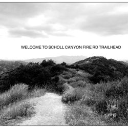
Overall a convenient & simple beginner hike for anyone interested in dipping a toe into nature. It's a narrow loop trail that meanders throughout the Canyon with a few benches to rest, read, or just sit in peace. The elevation gain is gradual and not strenuous by any means. I clocked 2.6 miles taking a detour down at the ridge motorway trail sign. I don't recommend it, stay on the loop. The gravel was loose, grade was steep, and the bottom loop around the power tower was grossly over grown. This trail is behind the Glendale Sports Complex. Two entrances: 1) end of parking lot by soccer fields, keep going till you enter by the wood bridges, 2) there's a trail marker at the entrance of the parking lot. Other points: bird watching, not crowded, clear paths, and, views of Hollywood, Glendale, Griffith Park, and the beach on a clear day.

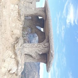
The Grand Opening of the Catalina Verdugo Trail is on Saturday, June 1, 2013. My friend Meg P., and I went hiking there today and we really liked it! It reminds me of the Rim of the Valley Trail at Deukmejian Park minus the radical, vertigo producing drop off on the side. There is a drop off, but the trail is wider. It just made me a little nervous when my friend Meg walked on the edge. There are two entrances to the Catalina Verdugo Trail. The first one is right by the entrance to the parking lot on the north side of the complex. The marker is right next to the street on the left, so it is visible. The second entrance to the trail is on the south side of the complex to the right of the soccer field. The website says the loop is 2 miles, but I used the Map My Hike ap and it registered at about 2.64. You can hike longer if you take the detour to the Ridge Motorway Trail. If you go that way you can hike all the way to La Canada if you head north or further down into Glendale if you head south. The Catalina Verdugo Trail was funded by the 2009 Competitive Trails Grant Program. A lot of chapparal was chopped down to create the trail and it hasn't been hauled away as of todays date. It was just thrown over the edge. Maybe they think it will turn into a natural mulch of some sort or perhaps they will haul it away. If I go to the Grand Opening on June 1, 2013 that question will be at the top of my list. If you stay on the loop trail it is approximately 2.64 miles long. It meanders in and out of canyons at an easy grade. If you start on the south side you will see the intersection to the Ridgeline Trail on your way up the hill. Turn right when you see the trail marker. I love the trail markers on this new trail. The trail will inperpret the history of the San Rafael Hills and the Verdugo Valley and is named after one of its earliest residents, Catalina Verdugo, the First Lady of the Rancho San Rafael. They have a few pedestals near the benches for some kind of informational plaques, but as of today they haven't been installed. I am sure they will be by the time of the Grand Opening on June 1, 2013.

The Catalina Verdugo Trail is new to Glendale. I do not think many people know about the hike yet because in all the times I have been on the trail, I have only seen 2 or 3 other hikers. I also saw one mountain biker; that seemed like an intense workout. This is a mild to moderate 2-mile hike. It takes approximately one hour to do the complete loop. I take my toddler, and I wear him in a hiking backpack. Bring water- the elevation change is pretty significant. Beautiful views of the city and mountains. On a clear day, you can see the ocean. And now for the most important tip- the main trailhead is to the right of the soccer fields (if you are facing fields). Do not enter soccer field area because those gates are locked. The first time we did this hike, we spent 20 minutes trying to figure out how to enter because all we saw were locked gates. I suggest a late afternoon hike because the sun bathes the mountains in light, and it makes for epic views.

Great local hike with well-mantained trails and great signage, making it hard to get lost. It's around 2.5 miles long, not too strenuous, and made a perfect walk before work. There are plenty of native plants to look at, if that's your thing. Great views of Glendale and Los Angeles. Free parking in the lot. read more


My first hike of the 2024 year! Catalina Verdugo Trail is a 2.8-mile loop trail near Glendale Sports Complex in Glendale, California. This trail is considered an easy route, with an elevation gain of 550 ft which takes an average of 1 h 24 min to complete. If you want to lengthen your hike, the CVT interconnects with Ridge Motor Way. The C.V. trail begins at the back of the soccer field (walk adjacent by the wired fence). I suggest visitors park at the very end of the parking lot. The loop ends at the entrance of the sport's complex by the baseball field-parking lot. I hiked the CVT today around noon with no humans on sight. It's just me and nature. The trail has a short steep elevation at base and mostly flat at top; trailhead has narrow single file path, copious tree shades, budding flora-fauna, and three rest benches. It's nice to hear the sounds of wild life despite the noise of The (2) freeway. The highlight of my hike was seeing a hummingbird. Overall, it's a nice quick easy hike and a good cardio/leg workout. I recommend this trail. read more


4 years ago
I'm not sure how busy this parking lot gets at the Glendale Sports Complex but there was plenty of free space available on Saturday after Thanksgiving. From the parking lot facing the sport fields start the hike to your left. The hike is moderate with easy inclines and around eight switchbacks at the end of the trail by the small wooden bridge. I saw small children walking this trail so it will be easy enough to hike for most all age groups. read more

Overall a convenient & simple beginner hike for anyone interested in dipping a toe into nature. It's a narrow loop trail that meanders throughout the Canyon with a few benches to rest, read, or just sit in peace. The elevation gain is gradual and not strenuous by any means. I clocked 2.6 miles taking a detour down at the ridge motorway trail sign. I don't recommend it, stay on the loop. The gravel was loose, grade was steep, and the bottom loop around the power tower was grossly over grown. This trail is behind the Glendale Sports Complex. Two entrances: 1) end of parking lot by soccer fields, keep going till you enter by the wood bridges, 2) there's a trail marker at the entrance of the parking lot. Other points: bird watching, not crowded, clear paths, and, views of Hollywood, Glendale, Griffith Park, and the beach on a clear day. read more


The Grand Opening of the Catalina Verdugo Trail is on Saturday, June 1, 2013. My friend Meg P., and I went hiking there today and we really liked it! It reminds me of the Rim of the Valley Trail at Deukmejian Park minus the radical, vertigo producing drop off on the side. There is a drop off, but the trail is wider. It just made me a little nervous when my friend Meg walked on the edge. There are two entrances to the Catalina Verdugo Trail. The first one is right by the entrance to the parking lot on the north side of the complex. The marker is right next to the street on the left, so it is visible. The second entrance to the trail is on the south side of the complex to the right of the soccer field. The website says the loop is 2 miles, but I used the Map My Hike ap and it registered at about 2.64. You can hike longer if you take the detour to the Ridge Motorway Trail. If you go that way you can hike all the way to La Canada if you head north or further down into Glendale if you head south. The Catalina Verdugo Trail was funded by the 2009 Competitive Trails Grant Program. A lot of chapparal was chopped down to create the trail and it hasn't been hauled away as of todays date. It was just thrown over the edge. Maybe they think it will turn into a natural mulch of some sort or perhaps they will haul it away. If I go to the Grand Opening on June 1, 2013 that question will be at the top of my list. If you stay on the loop trail it is approximately 2.64 miles long. It meanders in and out of canyons at an easy grade. If you start on the south side you will see the intersection to the Ridgeline Trail on your way up the hill. Turn right when you see the trail marker. I love the trail markers on this new trail. The trail will inperpret the history of the San Rafael Hills and the Verdugo Valley and is named after one of its earliest residents, Catalina Verdugo, the First Lady of the Rancho San Rafael. They have a few pedestals near the benches for some kind of informational plaques, but as of today they haven't been installed. I am sure they will be by the time of the Grand Opening on June 1, 2013. read more


12 years ago
The Catalina Verdugo Trail is new to Glendale. I do not think many people know about the hike yet because in all the times I have been on the trail, I have only seen 2 or 3 other hikers. I also saw one mountain biker; that seemed like an intense workout. This is a mild to moderate 2-mile hike. It takes approximately one hour to do the complete loop. I take my toddler, and I wear him in a hiking backpack. Bring water- the elevation change is pretty significant. Beautiful views of the city and mountains. On a clear day, you can see the ocean. And now for the most important tip- the main trailhead is to the right of the soccer fields (if you are facing fields). Do not enter soccer field area because those gates are locked. The first time we did this hike, we spent 20 minutes trying to figure out how to enter because all we saw were locked gates. I suggest a late afternoon hike because the sun bathes the mountains in light, and it makes for epic views. read more

4 years ago
12 years ago
9 years ago
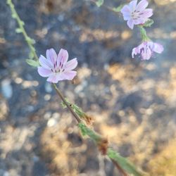
Easy/ Moderate Trail. Super tiny trail not meant for large groups. Can fit one person comfortably on trail, no side by side hikes. Some of the trail was a bit dangerous due to mud slides from the rain. Very helpful information on trail. I would have liked to see more flower/plant information & water fountain near picnic tables. I will return but maybe in a few years. Not worth the daily hike unless a local. read more


9 years ago
12 years ago
13 years ago
11 years ago
12 years ago
12 years ago
More info about Catalina Verdugo Trail
Ask the Community - Catalina Verdugo Trail
Review Highlights - Catalina Verdugo Trail
You might also consider


Catalina Verdugo Trail - hiking - Updated June 2026
Best of Glendale
People found Catalina Verdugo Trail by searching for…
Hiking Trails in Glendale, California
Beaches in Glendale, California
Walking Trails in Glendale, California
Running Trails in Glendale, California
Easy Hikes in Glendale, California
Dog Friendly Parks in Glendale, California
Dog Friendly Beaches in Glendale, California
Flower Field in Glendale, California
Lookout Points in Glendale, California
Beautiful Views in Glendale, California
Bike Paths in Glendale, California
Dog Friendly Hikes in Glendale, California
Places to Run in Glendale, California
Bird Sanctuary in Glendale, California
Dog Friendly Things to Do in Glendale, California
Trails in Glendale, California
Scenic Overlook in Glendale, California
Hiking Trails Kid Friendly in Glendale, California
Scenic View in Glendale, California
Dog Friendly Trails in Glendale, California
Hiking Club in Glendale, California
Trending Searches in Glendale, CA
Beaches near Catalina Verdugo Trail
Black Owned Nail Salons near Catalina Verdugo Trail
Boat Rental near Catalina Verdugo Trail
Cliff Jumping near Catalina Verdugo Trail
Creeks near Catalina Verdugo Trail
Day Trips near Catalina Verdugo Trail
Dog Friendly Trails near Catalina Verdugo Trail
Fishing Spots near Catalina Verdugo Trail
Free Kids Activities near Catalina Verdugo Trail
Jet Ski Rental near Catalina Verdugo Trail
Lakes & Ponds near Catalina Verdugo Trail
Off Road Trails near Catalina Verdugo Trail
Outdoor Activities near Catalina Verdugo Trail
Pick Your Own Farms near Catalina Verdugo Trail
Public Shower near Catalina Verdugo Trail
Rock Quarry near Catalina Verdugo Trail
Scenic Drive near Catalina Verdugo Trail
Scenic Night View near Catalina Verdugo Trail
Secluded Spots near Catalina Verdugo Trail
Soccer Store near Catalina Verdugo Trail
Splash Pad near Catalina Verdugo Trail
Strawberry Picking near Catalina Verdugo Trail
Sunrise View near Catalina Verdugo Trail
Swimming Holes near Catalina Verdugo Trail
Swimming Lakes near Catalina Verdugo Trail
Swimming Pools near Catalina Verdugo Trail
Watch Sunset near Catalina Verdugo Trail
Browse Articles
Browse Nearby
BEST of Glendale, California Coffee near Catalina Verdugo Trail
BEST of Glendale, California Restaurants near Catalina Verdugo Trail
BEST of Glendale, California Things to Do near Catalina Verdugo Trail
BEST of Glendale, California Breakfast near Catalina Verdugo Trail
BEST of Glendale, California Walking Trails near Catalina Verdugo Trail
BEST of Glendale, California Parks near Catalina Verdugo Trail
BEST of Glendale, California Hot Springs near Catalina Verdugo Trail
BEST of Glendale, California Campgrounds near Catalina Verdugo Trail
BEST of Glendale, California Sightseeing near Catalina Verdugo Trail
Browse Brands
Related Searches in Glendale, CA
Affordable Kayak Rental Services in Glendale, California
Best Fishing Locations and Guides in Glendale, California
Best Nature Trails for Hiking in Glendale, California
Best Places for Horseback Riding in Glendale, California
Check Out Off Road Trails in Glendale, California
Discover Dog Friendly Trails to Explore in Glendale, California
Discover Kid Friendly Hiking Trails in Glendale, California
Discover Scenic Hiking Trails in Glendale, California
Discover Scenic Mountain Bike Trails Near Glendale, California
Discover Scenic Waterfall Spots in Glendale, California
Discover Walking Parks in Glendale, California Near You
Discover a Hiking Trail in Glendale, California
Discover the Best Night Hike Trails in Glendale, California
Discover the Best Running Track in Glendale, California
Dog-Friendly Hikes With Dogs in Glendale, California
Enjoy Camping Adventures Around Glendale, California
Enjoy Exciting Mountain Biking Adventures in Glendale, California
Enjoy Kayaking Adventures in Glendale, California
Enjoy Tent Camping Spots Around Glendale, California
Enjoy a Beautiful Waterfall Hike in Glendale, California
Enjoy a Peaceful Nature Walk in Glendale, California
Enjoy the Best Walking Path in Glendale, California
Enjoy the Best Walking Trails in Glendale, California
Exciting Cliff Jumping Spots in Glendale, California
Explore Beautiful Parks and Green Spaces in Glendale, California
Explore Easy Hikes Perfect for All in Glendale, California
Explore Fun Activities to Do in Glendale, California
Explore Popular Campgrounds Near Glendale, California
Explore the Best Beach Spots in Glendale, California
Explore the Best Trail Options in Glendale, California
Family Friendly Hiking With Kids in Glendale, California
Find Beautiful Views in Glendale, California
Find the Best Parks for Picnics in Glendale, California
Find the Best Scenic View Locations in Glendale, California
Great Places to Walk in Glendale, California
Hike the Popular Waterfall Trail in Glendale, California
Hiking Trails With Waterfalls in Glendale, California
Off Leash Dog Hiking Trails in Glendale, California
Plan a Scenic Drive Route Near Glendale, California
Popular Outdoor Activities to Try in Glendale, California
Popular Picnic Spots to Visit in Glendale, California
Safe River Swimming Areas in Glendale, California
Safe and Fun Parks for Kids in Glendale, California
Top Climbing Spots and Gyms in Glendale, California
Top Paddleboarding Activities in Glendale, California
Top Running Trails to Explore in Glendale, California
Top Swimming Lakes to Enjoy in Glendale, California
Top Swimming Spots and Pools in Glendale, California
People who viewed Catalina Verdugo Trail also viewed
San Gabriel Peak
10 reviews
Strawberry Peak via Colby Canyon
6 reviews
Inspiration Point via Castle Canyon
191 reviews
Beaudry Loop Hike
145 reviews
Conservancy Trail
2 reviews
Hahamongna Watershed Park
58 reviews
Earl Canyon Motorway
5 reviews
Gabrielino Trail
81 reviews
Manzanita Ridge
10 reviews
Mount Lawlor Via Red Box
5 reviews