South Cumberland State Park Photos


More like South Cumberland State Park
Recommended Reviews - South Cumberland State Park
Start your review...

Reviews With Photos

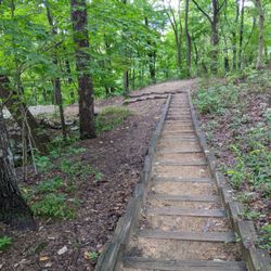
This park was wonderful, when you enter they have an information center with restrooms. We picked up a park map at the information center. There are tons of hiking trails of different difficulty levels. If you plan on hiking to the base of waterfalls make sure you have proper footwear. We also enjoyed all the overlook spots.

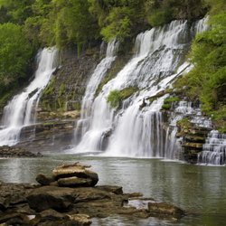
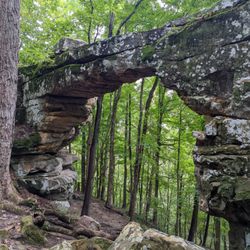
This may now be one of my all-time favorite state parks and hiking areas. Spent a weekend here and was not at ALL disappointed. Checked out the Savage Gulf area as well as the Fiery Gizzard trail. As much as I loved Savage Gulf and the Stone Door trail (a must-see), it felt like we entered another world on the Fiery Gizzard trail. There are some pretty serious issues with erosion and mud-slides toward the middle portion of the trail starting from the north end before you hit raven point, and I hope the park is evaluating how to solve these issues to both keep hikers safe and the environment in-tact and as unaffected as possible. Otherwise, though, this is the best trail I've been fortunate enough to hike to-date. From the rock scrambles, to the moss covered everything and the roaring river (we visited after it had been raining substantially for a few weeks), this area will more than live up to your expectations. Make sure you stop by the visitor center as well as the staff there are INCREDIBLY knowledgeable and helpful for planning your day/weekend in the area.

We did a hike in the Fiery Gizzard South/Foster Falls area of the park and it was beautiful. I highly recommend bringing a lightweight towel and maybe water shoes if you plan to swim out to the waterfall--which was amazing!! Absolutely would do that again. The trail was well marked and the park site and trail head marker gave great descriptions of all the trails. I wouldn't recommend this area for young kids, the hike was more moderate/difficult in some spots. We could not find an actual clear map of all the trails so were left a little confused on exactly what trail we were on or if it would have connected with others, but overall it was great.

South Cumberland State Park is HUGE. It's 30,000 acres, and spans over FOUR Tennessee counties. It has five small lakes, picnic tables, grills, pavilions, tennis courts, basketball courts, volleyball courts, a baseball diamond, a gift shop, a museum, a cabin, campsites, rock climbing, rappelling, boating, and swimming. Oh, and lest we forget... over 90 miles of hiking. The 12 mile, one way trail, the Fiery Gizzard, is considered one of the best trails in the country. We know it was established in 1978, and there are sites showing old coal ovens and other historic sites. I can't wait to come back again... and again.. and again.

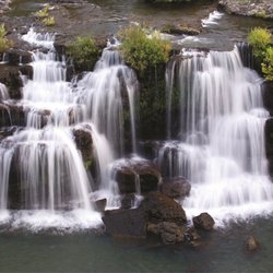
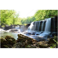
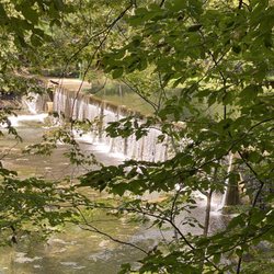
FIERY GIZZARD and GRUNDY TRAILHEADS in South Cumberland Recreation Area Sunday, January 19th, 2014 Tony and I went hiking in the South Cumberland State Park at the Grundy Trail Nature Area in Tracy City . It took us 2 1/2 hrs to hike 3.2 miles. Not too bad for 2 people over 50 with heart conditions... Directions: I-24 exit 134 Monteagle, take Rt 41South to Tracy City. On Right turn on 3rd street go to the Tracy City Elementary School, just past you will turn Right on Marion Street, go back to the Brown sign showing Fiery Gizzard Trail back near the softball field for the school, you will see on the left parking spots paved with bathrooms, shelter with picnic tables and signs.. Sign in to let them know you are hiking. Two trails one near the sign where you register marked Fiery Gizzard and the second located between the shelter picnic area and the bathrooms that is label : Grundy Trail 2.0 mile loop following the white tag markers 1/2 mile in there is a CCC campsite following blue marker trail to the Right Free Camping available no electric, primitive sites 1 mile into the hike you will come to the Hanes Waterfall 6' ft and swimming hole after you take the steps (approximately 24) down to the water's edge. Another .3 miles you will arrive at the bridge crossing, through an area referred to as Black Canyon, this will take you further into the park for hiking but if you venture .2 miles you will arrive at another waterfall, Chimney Rocks Waterfall, which is 20' ft drop into the narrow canyon and then an additional .4 miles to the Sycamore Falls, which is a 12' ft fall with gorgeous swimming hole. From here you can continue on the left to the Dog Hole Trail... At this point, we double back .6 miles back to the bridge and mada a Right to then continue on the White marker path back towards the parking lot .7 miles. On this part of the trail you will pass the Blue Hole Waterfall 9' high and swimming hole is 7' ft deep and the Cave Spring Rockhouse overhang rock cliff with the Hemlock Tree over 500 plus yrs. before climbing back to the parking lot and ending up at the Fiery Gizzard Trailhead. If you walk this entirely to the Sycamore falls and back to the parking lot you will have hiked 3.2 miles. Some of it is very narrow with high steep drops to the water's edge with loose footing and rocks so please be careful there are not railings for support or safety. If you are hiking with Children please be warne


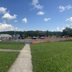
This is kind of a strange park as several sites are distributed widely but considered under the same umbrella. I visited several, including their headquarters with a wounded hawk at the entrance, a rainforest-y loop trail, and a splendid-looking waterfall. Individually, the sites were nice but not the best the state has to offer, but when one considers the sum total of various environs and the fact that Tennessee state parks do not charge admission, I struggle to criticize. I noted that a park ranger gently pushed someone to leash their dog on the trail without getting into a confrontation. read more


1 year ago
Denny Cove Falls trail is a wonderful, moderate hike. Out & back to a gorgeous waterfall. The trail is well marked and maintained. It's a long gravel road to the parking lot dedicated just to this particular trailhead. read more

1 year ago
This park was wonderful, when you enter they have an information center with restrooms. We picked up a park map at the information center. There are tons of hiking trails of different difficulty levels. If you plan on hiking to the base of waterfalls make sure you have proper footwear. We also enjoyed all the overlook spots. read more

This may now be one of my all-time favorite state parks and hiking areas. Spent a weekend here and was not at ALL disappointed. Checked out the Savage Gulf area as well as the Fiery Gizzard trail. As much as I loved Savage Gulf and the Stone Door trail (a must-see), it felt like we entered another world on the Fiery Gizzard trail. There are some pretty serious issues with erosion and mud-slides toward the middle portion of the trail starting from the north end before you hit raven point, and I hope the park is evaluating how to solve these issues to both keep hikers safe and the environment in-tact and as unaffected as possible. Otherwise, though, this is the best trail I've been fortunate enough to hike to-date. From the rock scrambles, to the moss covered everything and the roaring river (we visited after it had been raining substantially for a few weeks), this area will more than live up to your expectations. Make sure you stop by the visitor center as well as the staff there are INCREDIBLY knowledgeable and helpful for planning your day/weekend in the area. read more


4 years ago
We did a hike in the Fiery Gizzard South/Foster Falls area of the park and it was beautiful. I highly recommend bringing a lightweight towel and maybe water shoes if you plan to swim out to the waterfall--which was amazing!! Absolutely would do that again. The trail was well marked and the park site and trail head marker gave great descriptions of all the trails. I wouldn't recommend this area for young kids, the hike was more moderate/difficult in some spots. We could not find an actual clear map of all the trails so were left a little confused on exactly what trail we were on or if it would have connected with others, but overall it was great. read more


South Cumberland State Park is HUGE. It's 30,000 acres, and spans over FOUR Tennessee counties. It has five small lakes, picnic tables, grills, pavilions, tennis courts, basketball courts, volleyball courts, a baseball diamond, a gift shop, a museum, a cabin, campsites, rock climbing, rappelling, boating, and swimming. Oh, and lest we forget... over 90 miles of hiking. The 12 mile, one way trail, the Fiery Gizzard, is considered one of the best trails in the country. We know it was established in 1978, and there are sites showing old coal ovens and other historic sites. I can't wait to come back again... and again.. and again. read more


12 years ago
FIERY GIZZARD and GRUNDY TRAILHEADS in South Cumberland Recreation Area Sunday, January 19th, 2014 Tony and I went hiking in the South Cumberland State Park at the Grundy Trail Nature Area in Tracy City . It took us 2 1/2 hrs to hike 3.2 miles. Not too bad for 2 people over 50 with heart conditions... Directions: I-24 exit 134 Monteagle, take Rt 41South to Tracy City. On Right turn on 3rd street go to the Tracy City Elementary School, just past you will turn Right on Marion Street, go back to the Brown sign showing Fiery Gizzard Trail back near the softball field for the school, you will see on the left parking spots paved with bathrooms, shelter with picnic tables and signs.. Sign in to let them know you are hiking. Two trails one near the sign where you register marked Fiery Gizzard and the second located between the shelter picnic area and the bathrooms that is label : Grundy Trail 2.0 mile loop following the white tag markers 1/2 mile in there is a CCC campsite following blue marker trail to the Right Free Camping available no electric, primitive sites 1 mile into the hike you will come to the Hanes Waterfall 6' ft and swimming hole after you take the steps (approximately 24) down to the water's edge. Another .3 miles you will arrive at the bridge crossing, through an area referred to as Black Canyon, this will take you further into the park for hiking but if you venture .2 miles you will arrive at another waterfall, Chimney Rocks Waterfall, which is 20' ft drop into the narrow canyon and then an additional .4 miles to the Sycamore Falls, which is a 12' ft fall with gorgeous swimming hole. From here you can continue on the left to the Dog Hole Trail... At this point, we double back .6 miles back to the bridge and mada a Right to then continue on the White marker path back towards the parking lot .7 miles. On this part of the trail you will pass the Blue Hole Waterfall 9' high and swimming hole is 7' ft deep and the Cave Spring Rockhouse overhang rock cliff with the Hemlock Tree over 500 plus yrs. before climbing back to the parking lot and ending up at the Fiery Gizzard Trailhead. If you walk this entirely to the Sycamore falls and back to the parking lot you will have hiked 3.2 miles. Some of it is very narrow with high steep drops to the water's edge with loose footing and rocks so please be careful there are not railings for support or safety. If you are hiking with Children please be warne read more


7 years ago
Very nice State Park. I enjoyed the hike with all the scenic paths we found. Worth a visit. read more


9 years ago
Absolutely beautiful breathtaking views! There's some great overlooks the whole family can enjoy, but when you get to the cliffs there are no guardrails so be careful if you have little kids. read more

7 years ago
8 years ago
10 years ago
More info about South Cumberland State Park
11745 US 41
Monteagle, TN 37356
Directions
(931) 924-2980
Call Now
Visit Website
https://tnstateparks.com
Hours
Indoor Amenities
Outdoor Amenities
Other Amenities
From the Business
Ask the Community - South Cumberland State Park
Review Highlights - South Cumberland State Park


South Cumberland State Park - hiking - Updated June 2026
Best of Monteagle
People found South Cumberland State Park by searching for…
Hiking Trails With Waterfalls in Monteagle, TN
Swimming Holes in Monteagle, TN
Scenic Overlook in Monteagle, TN
Basketball Courts in Monteagle, TN
Rock Climbing in Monteagle, TN
Off Road Trails in Monteagle, TN
Baseball Fields in Monteagle, TN
River Swimming in Monteagle, TN
Trending Searches in Monteagle, TN
Bait And Tackle Shop near South Cumberland State Park
Beaches near South Cumberland State Park
Boat Rental near South Cumberland State Park
Cliff Jumping near South Cumberland State Park
Day Trips near South Cumberland State Park
Dog Friendly Trails near South Cumberland State Park
Fishing Spots near South Cumberland State Park
Kayak Rental near South Cumberland State Park
Lakes near South Cumberland State Park
Long Term Rv Parking near South Cumberland State Park
Off Road Trails near South Cumberland State Park
Outdoor Basketball Courts near South Cumberland State Park
Pick Your Own Farms near South Cumberland State Park
River Swimming near South Cumberland State Park
Rv Campgrounds near South Cumberland State Park
Scenic Drive near South Cumberland State Park
Splash Pad near South Cumberland State Park
Swimming Holes near South Cumberland State Park
Swimming Lakes near South Cumberland State Park
Swimming Pools near South Cumberland State Park
Watch Sunset near South Cumberland State Park
Browse Articles
Browse Nearby
BEST of Monteagle, Tennessee Restaurants near South Cumberland State Park
BEST of Monteagle, Tennessee Coffee near South Cumberland State Park
BEST of Monteagle, Tennessee Breakfast near South Cumberland State Park
BEST of Monteagle, Tennessee Shopping near South Cumberland State Park
BEST of Monteagle, Tennessee Campgrounds near South Cumberland State Park
Browse Brands
Related Cost Guides
Related Searches in Monteagle, TN
Affordable Long Term RV Parking in Monteagle, Tennessee
Best Fishing Locations and Guides in Monteagle, Tennessee
Best Nature Trails for Hiking in Monteagle, Tennessee
Best Off Leash Dog Parks in Monteagle, Tennessee
Best Parks for Parties and Events in Monteagle, Tennessee
Best Places for Horseback Riding in Monteagle, Tennessee
Best Water Parks for Kids in Monteagle, Tennessee
Browse Top Hotels in Monteagle, Tennessee for Your Stay
Browse Vacation Rentals to Book in Monteagle, Tennessee
Check Out Great Playgrounds in Monteagle, Tennessee
Check Out Off Road Trails in Monteagle, Tennessee
Discover Baseball Fields Around Monteagle, Tennessee
Discover Dog Friendly Trails to Explore in Monteagle, Tennessee
Discover Free Campgrounds in Monteagle, Tennessee Area
Discover Fun Toddler Parks in Monteagle, Tennessee for Your Little One
Discover Popular Bike Trails in Monteagle, Tennessee
Discover Popular Photo Spots in Monteagle, Tennessee
Discover Scenic Beach Camping Sites in Monteagle, Tennessee
Discover Soccer Fields in Monteagle, Tennessee Near You
Discover a Hiking Trail in Monteagle, Tennessee
Discover the Best Night Hike Trails in Monteagle, Tennessee
Dog-Friendly Hikes With Dogs in Monteagle, Tennessee
Enjoy Camping Adventures Around Monteagle, Tennessee
Enjoy Exciting Mountain Biking Adventures in Monteagle, Tennessee
Enjoy Hiking Adventures in Monteagle, Tennessee
Enjoy Tent Camping Spots Around Monteagle, Tennessee
Enjoy a Relaxing Bed & Breakfast Experience in Monteagle, Tennessee
Enjoy the Best Picnic Spots and Ideas in Monteagle, Tennessee
Enjoy the Best Tubing Experiences in Monteagle, Tennessee
Enjoy the Best Walking Trails in Monteagle, Tennessee
Exciting Cliff Jumping Spots in Monteagle, Tennessee
Experience Stunning Sunset Views in Monteagle, Tennessee
Explore Beautiful Parks and Green Spaces in Monteagle, Tennessee
Explore Bike Rentals Throughout Monteagle, Tennessee
Explore Easy Hikes Perfect for All in Monteagle, Tennessee
Explore Family-Friendly Zoos and Wildlife in Monteagle, Tennessee
Explore Free Picnic Areas Around Monteagle, Tennessee
Explore Landmarks & Historical Buildings in Monteagle, Tennessee
Explore Parks With Pull Up Bars in Monteagle, Tennessee
Explore Popular Campgrounds Near Monteagle, Tennessee
Explore Popular Scenic Overlook Points in Monteagle, Tennessee
Explore Popular Scenic Views Near Monteagle, Tennessee
Explore Scenic Lakes to Visit in Monteagle, Tennessee
Explore Secret Spots Worth Visiting in Monteagle, Tennessee
Explore Summer Camps for All Ages in Monteagle, Tennessee
Explore Top Gyms in Monteagle, Tennessee Now
Explore Top Water Parks in Monteagle, Tennessee Today
Explore the Best Boating Spots in Monteagle, Tennessee
People who viewed South Cumberland State Park also viewed
Sasquatch Farm
11 reviews
Natural Bridge State Natural Area
2 reviews
Circle E Guest Ranch
2 reviews
Short Creek RV Resort
2 reviews
Shellmound Campground
4 reviews
Fairview Devil Step Campground
5 reviews
Jungle Boat
1 review
Bigmouth Cave Retreat
2 reviews
Clearwater Cove RV Resort
7 reviews
Ledford Mill Bed and Breakfast
3 reviews