Wabash Heritage Trail Photos


More like Wabash Heritage Trail
Recommended Reviews - Wabash Heritage Trail
Start your review...

Reviews With Photos

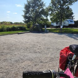
(Taken from another website this describes how to get to the trail): Descrption: The trail is accessible by sidewalks from Purdue University. There are 2 paved spurs which connect from the Myers pedestrian bridge to US231/SR43 in West Lafayette. From the north, begins near Tippecanoe Battlefield County Park and follows Burnetts Creek to the Wabash, passes Prophets Rock, Davis Ferry County Park, then follows the Wabash to Lafayette. From W. Lafayette, the trail begins at Tawpawingo Park, across the plaza bridge from the August Jazz-Blues Festival Site and continues south to Fort Ouiatenon, site of the Feast of the Hunters Moon in late Fall. A beautiful walk shaded by characteristic central IN trees such as cottonwoods, sycamores, maples, and oaks. NORTH: At the north end of the trail, nearly 4 miles of footpath wind along Burnett Creek between Tippecanoe Battlefield and Davis Ferry Park, where an old iron truss bridge provides crossing over the river. MIDDLE: In the middle, about 5 miles of trail run along the east bank of the Wabash, through woods and fields and Lafayette Municipal Golf Course and McAllister, Riverfront, and Digby Parks to Myers Bridge, a pedestrian plaza connecting Lafayette and West Lafayette. Some of the trail is asphalt in the downtown vicinity, about 1.5 miles in Lafayette north of Riehle Plaza and 1.0 mile in West Lafayette In Tapawingo Park. The beautifully restored Big Four depot is an Amtrak stop en route to Chicago and Indianapolis. MY OPINION: The trail is pretty neat during the fall and spring months (not so much during the snowy season). I needed a break from Campus life and took my bike down to the bridge that crosses the Wabash River into Lafayette and hopped on the trail. There weren't many people on it during the middle of the day, and it was a little sketchy riding through corn fields on a paved path by myself. I thought someone might jump out at me- but I was fine. I suggest not going alone though, just for safety- you never know. There's plenty of trees and a few benches along the path. A good way to take a break from crammimg things in your head at Purdue.

5 years ago
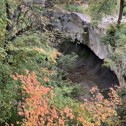
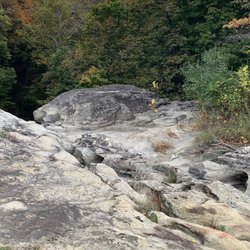
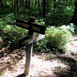
The Wabash Heritage Trail is 13 miles long making it a perfect training ground for a mini marathon. However, today we were exploring nature with our granddaughter. We started on the north end at Battleground Memorial. At the head of the trail is a sweet little nature center (Wah-ba-shik-a Nature Center) filled with descriptions of wildlife and fauna that are native to the area. My granddaughter was delighted to see the big white owl that greeted us at the door. The volunteer at the Center was welcoming and admission was free. They had maps for the trail that you can take. There are also special programs offered throughout the year. The trail starts and Battleground and extends all the way to Fort Ouiatenon. We only toured a couple miles along a creek that eventually meets the Wabash River. The trail is mulch covered and easy to navigate by foot. It would be difficult to maneuver a stroller or wheelchair onto the trail. The trail is lined with very large sycamores, oaks, walnuts and other trees native to the area. Some of the trees were at least 300 years older. The creek is clear and suitable for a little stomping. There are occasional benches along the trail as well as informational markers. There were also picnic tables and a water fountain at the trail head. We did not see any restroom facilities, but there were probably some in the Battle Ground Museum. The hike is quiet during the week. You can enjoy the sounds of birds and squirrels. I can imagine how beautiful the trail is when the leaves are changing color. There is some highway traffic noise as you get closer to the highway. The trail does not loop, so you have to backtrack to return to your car. There was plenty of parking at the Memorial. The map indicated that there were about five parking lots along the trail. We enjoyed the hike and will return to do a different section soon. I highly recommend. read more


18 years ago
(Taken from another website this describes how to get to the trail): Descrption: The trail is accessible by sidewalks from Purdue University. There are 2 paved spurs which connect from the Myers pedestrian bridge to US231/SR43 in West Lafayette. From the north, begins near Tippecanoe Battlefield County Park and follows Burnetts Creek to the Wabash, passes Prophets Rock, Davis Ferry County Park, then follows the Wabash to Lafayette. From W. Lafayette, the trail begins at Tawpawingo Park, across the plaza bridge from the August Jazz-Blues Festival Site and continues south to Fort Ouiatenon, site of the Feast of the Hunters Moon in late Fall. A beautiful walk shaded by characteristic central IN trees such as cottonwoods, sycamores, maples, and oaks. NORTH: At the north end of the trail, nearly 4 miles of footpath wind along Burnett Creek between Tippecanoe Battlefield and Davis Ferry Park, where an old iron truss bridge provides crossing over the river. MIDDLE: In the middle, about 5 miles of trail run along the east bank of the Wabash, through woods and fields and Lafayette Municipal Golf Course and McAllister, Riverfront, and Digby Parks to Myers Bridge, a pedestrian plaza connecting Lafayette and West Lafayette. Some of the trail is asphalt in the downtown vicinity, about 1.5 miles in Lafayette north of Riehle Plaza and 1.0 mile in West Lafayette In Tapawingo Park. The beautifully restored Big Four depot is an Amtrak stop en route to Chicago and Indianapolis. MY OPINION: The trail is pretty neat during the fall and spring months (not so much during the snowy season). I needed a break from Campus life and took my bike down to the bridge that crosses the Wabash River into Lafayette and hopped on the trail. There weren't many people on it during the middle of the day, and it was a little sketchy riding through corn fields on a paved path by myself. I thought someone might jump out at me- but I was fine. I suggest not going alone though, just for safety- you never know. There's plenty of trees and a few benches along the path. A good way to take a break from crammimg things in your head at Purdue. read more

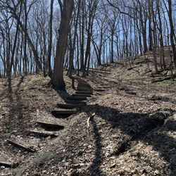
So I stayed at the Hilton Garden Inn a few weeks ago and needed to go for a long run for my training. I wanted a trail and Lindsay H's review peak'd my interest in this trail. I had always known it was there when I went to Purdue but never tried it out. For reference... there is paved trail...if you are looking for a run less than 5mi you are totally golden. If you are looking for longer runs on paved surfaces this is not it. Run around campus or something. most of this is very much wooded trail. If you are a trail runner, this is a flat (mostly), obstruction free (mostly) wooded trail once you get north of the golf course. It was quite the fun trail run honestly, I was just not clear on this and was looking for a paved trail. Also it doesnt seem to be that many people use the trail which is unfortunate since it is very nice.... read more


11 years ago
More info about Wabash Heritage Trail
West Lafayette, IN 47907
Directions
Hours
Outdoor Amenities
Ask the Community - Wabash Heritage Trail


Wabash Heritage Trail - hiking - Updated June 2026
Best of West Lafayette
People found Wabash Heritage Trail by searching for…
Things to Do in West Lafayette, IN
Scenic View in West Lafayette, IN
Hiking Trails in West Lafayette, IN
Picnic Areas in West Lafayette, IN
Walking Trails in West Lafayette, IN
Waterfalls in West Lafayette, IN
Secret Spots in West Lafayette, IN
Beautiful Views in West Lafayette, IN
Running Trails in West Lafayette, IN
Secluded Spots in West Lafayette, IN
Things to Do at Night in West Lafayette, IN
Natural Hot Springs in West Lafayette, IN
Nature Center in West Lafayette, IN
River Walk in West Lafayette, IN
Scenic Overlook in West Lafayette, IN
Parks for Kids in West Lafayette, IN
Fun Places to Go in West Lafayette, IN
View Points in West Lafayette, IN
Off Leash Dog Hikes in West Lafayette, IN
Trending Searches in West Lafayette, IN
Beaches near Wabash Heritage Trail
Black Owned Nail Salons near Wabash Heritage Trail
Boat Rental near Wabash Heritage Trail
Cliff Jumping near Wabash Heritage Trail
Day Trips near Wabash Heritage Trail
Fishing Spots near Wabash Heritage Trail
Free Kids Activities near Wabash Heritage Trail
Kayak Rental near Wabash Heritage Trail
Lakes & Ponds near Wabash Heritage Trail
Off Road Trails near Wabash Heritage Trail
Outdoor Activities near Wabash Heritage Trail
Pick Your Own Farms near Wabash Heritage Trail
Public Shower near Wabash Heritage Trail
Rock Quarry near Wabash Heritage Trail
Scenic Drive near Wabash Heritage Trail
Secluded Spots near Wabash Heritage Trail
Soccer Store near Wabash Heritage Trail
Splash Pad near Wabash Heritage Trail
Strawberry Picking near Wabash Heritage Trail
Sunrise View near Wabash Heritage Trail
Swimming Holes near Wabash Heritage Trail
Swimming Lakes near Wabash Heritage Trail
Swimming Pools near Wabash Heritage Trail
Urban Exploration near Wabash Heritage Trail
Watch Sunset near Wabash Heritage Trail
Browse Articles
Browse Nearby
BEST of West Lafayette, Indiana Restaurants near Wabash Heritage Trail
BEST of West Lafayette, Indiana Coffee near Wabash Heritage Trail
BEST of West Lafayette, Indiana Things to Do near Wabash Heritage Trail
BEST of West Lafayette, Indiana Parks near Wabash Heritage Trail
BEST of West Lafayette, Indiana Lakes near Wabash Heritage Trail
BEST of West Lafayette, Indiana Campgrounds near Wabash Heritage Trail
BEST of West Lafayette, Indiana Breakfast near Wabash Heritage Trail
BEST of West Lafayette, Indiana Taxis near Wabash Heritage Trail
Browse Brands
Related Searches in West Lafayette, IN
Best Fishing Locations and Guides in West Lafayette, Indiana
Best Fun Things to Do in West Lafayette, Indiana
Best Places for Horseback Riding in West Lafayette, Indiana
Best Places for Stunning Views in West Lafayette, Indiana
Check Out Off Road Trails in West Lafayette, Indiana
Discover Dog Friendly Trails to Explore in West Lafayette, Indiana
Discover Lakes & Ponds to Explore in West Lafayette, Indiana
Discover Popular Photo Spots in West Lafayette, Indiana
Discover Top Boat Tours in West Lafayette, Indiana for All Ages
Discover a Hiking Trail in West Lafayette, Indiana
Discover the Best Running Track in West Lafayette, Indiana
Dog-Friendly Hikes With Dogs in West Lafayette, Indiana
Enjoy Camping Adventures Around West Lafayette, Indiana
Enjoy Exciting Mountain Biking Adventures in West Lafayette, Indiana
Enjoy the Best Family Activities in West Lafayette, Indiana
Enjoy the Best Tubing Experiences in West Lafayette, Indiana
Enjoy the Best Walking Trails in West Lafayette, Indiana
Experience Stunning Sunset Views in West Lafayette, Indiana
Explore Beautiful Botanical Gardens in West Lafayette, Indiana
Explore Beautiful Parks and Green Spaces in West Lafayette, Indiana
Explore Bike Rentals Throughout West Lafayette, Indiana
Explore Easy Hikes Perfect for All in West Lafayette, Indiana
Explore Free Things to Do Around West Lafayette, Indiana
Explore Fun Activities to Do in West Lafayette, Indiana
Explore Popular Campgrounds Near West Lafayette, Indiana
Explore Popular Scenic Overlook Points in West Lafayette, Indiana
Explore Scenic Lakes to Visit in West Lafayette, Indiana
Explore Secret Spots Worth Visiting in West Lafayette, Indiana
Explore Top Dog Parks in West Lafayette, Indiana Near You
Explore Top Water Parks in West Lafayette, Indiana Today
Explore the Best Boating Spots in West Lafayette, Indiana
Family Friendly Hiking With Kids in West Lafayette, Indiana
Find Beautiful Views in West Lafayette, Indiana
Find Popular Ziplining Spots Around West Lafayette, Indiana
Find Top Dog Swimming Spots in West Lafayette, Indiana
Find Top-Rated Disc Golf in West Lafayette, Indiana
Find the Best Playgrounds to Visit in West Lafayette, Indiana
Find the Best Scenic View Locations in West Lafayette, Indiana
Off Leash Dog Hiking Trails in West Lafayette, Indiana
Popular Fishing Spots to Explore in West Lafayette, Indiana
Popular Kids Activities in West Lafayette, Indiana
Popular Outdoor Activities to Try in West Lafayette, Indiana
Popular Things to Do in West Lafayette, Indiana
Safe River Swimming Areas in West Lafayette, Indiana
Top Paddleboarding Activities in West Lafayette, Indiana
Top Playgrounds for Kids to Enjoy in West Lafayette, Indiana
Top Running Trails to Explore in West Lafayette, Indiana
Top Swimming Lakes to Enjoy in West Lafayette, Indiana