Celery Bog Nature Area Photos



You might also consider


More like Celery Bog Nature Area
Recommended Reviews - Celery Bog Nature Area
Start your review...


Reviews With Photos


Stopped in here while visiting Purdue. Pretty cool area to take a stroll in. Some easy mulched trails to cruise around on. Down to the water. Good parking. Visitor center with bathroom.


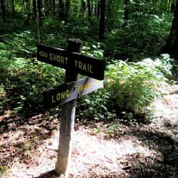
There is a lot to like about this park. The Lilly Nature Center has activities for kids to play and learn about the ecosystems within the park. The Wabash Heritage Trail runs through so those who are into fitness can get a good workout. The paths through the woods offer a few viewing spots to overlook Celery Bog which is often home to migrating birds that are attracted to water. Additional trails go through the prairie and savannas that can be found on the nearly 200 acre site. Parking is available in lots midway back from the road and also close to the nature center. The only negative I have about the place is that I didn't see any mini maps to carry with me once I got on the trails. The trails are not regular large loops, but combinations of loops which can make it easy to get lost. I did notice a few informational "You are Here" stands along the wooded paths, but other than that, there was very little information along the trails. When the short trail maxes out around 1.5 miles and the longer runs over 4, it can be really helpful to stay on one if you are watching your time and energy! Add to that the Heritage trail that goes on for miles and you can see how better identification would be helpful to new visitors. The park also has a couple public art installations as well. Overall, the park is well kept and is quite colorful in season. Review #1137


5 stars. Nice wide path. There are nice restrooms located at the education center. We saw lots of wildlife: squirrels, deer, raccoons, birds, etc. The raccoon was the fattest I've ever seen - and he crawled out of the garbage can at the education center. Scared me to death! Excellent for jogging, walking, biking, whatever. read more

The set of trails here runs by what I would call a lake through some woods, wetlands, and meadows. It isn't the most amazing environment I've ever seen by any means, but it offers a nice variety of sights, and perhaps moreso a distinctive soundscape. The infrastructure was quite well maintained, with signs apologizing that some trees had to be cut down due to parasites, but overall a clean set of trails, a visitor center with needed facilities, and a bike path running through. I did not see any celery; I'm not sure if I'm missing something or if this is just my own ignorance of what the actual plant looks like. read more


This nature area is quite beautiful. The trails are well marked. There are signs that are informational throughout the park. There is a mix of mulch trails and paved sidewalks. There is a large variety of trees, shrubs, and wild flowers. On my visit there were a nice mix of animals to see ~ Rabbits , squirrels, geese, frogs, turtles, and multiple herons. A guy walking his dog also said there was a deer on the trail but we didn't see it. There is a nature center but we didn't go in. It is free to visit the park and there is plenty of parking. It is also dog friendly but they have to be leashed. read more

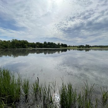


There is a lot to like about this park. The Lilly Nature Center has activities for kids to play and learn about the ecosystems within the park. The Wabash Heritage Trail runs through so those who are into fitness can get a good workout. The paths through the woods offer a few viewing spots to overlook Celery Bog which is often home to migrating birds that are attracted to water. Additional trails go through the prairie and savannas that can be found on the nearly 200 acre site. Parking is available in lots midway back from the road and also close to the nature center. The only negative I have about the place is that I didn't see any mini maps to carry with me once I got on the trails. The trails are not regular large loops, but combinations of loops which can make it easy to get lost. I did notice a few informational "You are Here" stands along the wooded paths, but other than that, there was very little information along the trails. When the short trail maxes out around 1.5 miles and the longer runs over 4, it can be really helpful to stay on one if you are watching your time and energy! Add to that the Heritage trail that goes on for miles and you can see how better identification would be helpful to new visitors. The park also has a couple public art installations as well. Overall, the park is well kept and is quite colorful in season. Review #1137 read more


4 years ago

6 years ago
Celery Bog is a great place to see wildlife and is one of the top spots for birding in Indiana! My boyfriend and I live in West Lafayette and come here often. We've seen a variety of warblers, bald eagles, ospreys, cormorants, wood ducks, orioles, and cedar waxwings - just to name a few :). There are wooded trail paths next to the bog, a paved walking path, and a sidewalk that runs along the bridge to get a great view of the water. The park is relatively small but if you spend some time in it and bring binoculars you can soak up all it has to offer. read more


7 years ago
More info about Celery Bog Nature Area

Ask the Community - Celery Bog Nature Area



















Celery Bog Nature Area - parks - Updated September 2026
Best of West Lafayette
People found Celery Bog Nature Area by searching for…
Water Parks in West Lafayette, IN
Places to Take Pictures in West Lafayette, IN
Things to Do in West Lafayette, IN
Scenic View in West Lafayette, IN
Hiking Trails in West Lafayette, IN
Dog Swimming in West Lafayette, IN
Walking Trails in West Lafayette, IN
Flower Fields in West Lafayette, IN
Attractions in West Lafayette, IN
Beautiful Views in West Lafayette, IN
Waterfalls in West Lafayette, IN
Picnic Areas in West Lafayette, IN
Fun Things to Do on Your Birthday in West Lafayette, IN
Running Trails in West Lafayette, IN
Outdoor Gym in West Lafayette, IN
Natural Hot Springs in West Lafayette, IN
Scenic Drive in West Lafayette, IN
Photo Spots in West Lafayette, IN
Lakes & Ponds in West Lafayette, IN
Public Beaches in West Lafayette, IN
Park & Forests in West Lafayette, IN
Trending Searches in West Lafayette, IN
Apple Orchards near Celery Bog Nature Area
Apple Picking near Celery Bog Nature Area
Archery near Celery Bog Nature Area
Barbershop near Celery Bog Nature Area
Baseball Fields near Celery Bog Nature Area
Blow Dry Bar near Celery Bog Nature Area
Cliff Jumping near Celery Bog Nature Area
Consignment Shops near Celery Bog Nature Area
Corn Maze near Celery Bog Nature Area
Dog Friendly Things To Do near Celery Bog Nature Area
Dog Parks near Celery Bog Nature Area
Dog Swimming near Celery Bog Nature Area
Dress Shops near Celery Bog Nature Area
Eyebrow Threading near Celery Bog Nature Area
Eyelash Extensions near Celery Bog Nature Area
Hiking near Celery Bog Nature Area
Kids Birthday Party near Celery Bog Nature Area
Makeup Artists near Celery Bog Nature Area
Off Road Trails near Celery Bog Nature Area
Parks near Celery Bog Nature Area
Photo Spots near Celery Bog Nature Area
Picnic Areas near Celery Bog Nature Area
Places To Take Pictures near Celery Bog Nature Area
Playgrounds near Celery Bog Nature Area
Private Schools near Celery Bog Nature Area
Public Shower near Celery Bog Nature Area
Public Tennis Courts near Celery Bog Nature Area
River Swimming near Celery Bog Nature Area
Rock Quarry near Celery Bog Nature Area
Browse Articles
Browse Nearby
BEST of West Lafayette, Indiana Coffee near Celery Bog Nature Area
BEST of West Lafayette, Indiana Restaurants near Celery Bog Nature Area
BEST of West Lafayette, Indiana Playgrounds near Celery Bog Nature Area
BEST of West Lafayette, Indiana Things to Do near Celery Bog Nature Area
BEST of West Lafayette, Indiana Picnic Areas near Celery Bog Nature Area
BEST of West Lafayette, Indiana Campgrounds near Celery Bog Nature Area
BEST of West Lafayette, Indiana Breakfast near Celery Bog Nature Area
BEST of West Lafayette, Indiana Hostels near Celery Bog Nature Area
Browse Brands
Related Searches in West Lafayette, IN
Affordable Canoe Rental Options in West Lafayette, Indiana
Affordable Kayak Rental Services in West Lafayette, Indiana
Best Dog Hiking Trails Around West Lafayette, Indiana
Best Fishing Locations and Guides in West Lafayette, Indiana
Best Parks for Parties and Events in West Lafayette, Indiana
Best Places for Horseback Riding in West Lafayette, Indiana
Best Water Parks for Kids in West Lafayette, Indiana
Check Out Off Road Trails in West Lafayette, Indiana
Discover Baseball Fields Around West Lafayette, Indiana
Discover Dog Friendly Trails to Explore in West Lafayette, Indiana
Discover Fun Toddler Parks in West Lafayette, Indiana for Your Little One
Discover Lakes & Ponds to Explore in West Lafayette, Indiana
Discover Popular Bike Trails in West Lafayette, Indiana
Discover Popular Photo Spots in West Lafayette, Indiana
Discover Top Nature Parks to Visit in West Lafayette, Indiana
Discover a Hiking Trail in West Lafayette, Indiana
Discover the Best Beaches in West Lafayette, Indiana
Discover the Best Night Hike Trails in West Lafayette, Indiana
Dog-Friendly Hikes With Dogs in West Lafayette, Indiana
Enjoy Camping Adventures Around West Lafayette, Indiana
Enjoy Exciting Mountain Biking Adventures in West Lafayette, Indiana
Enjoy Hiking Adventures in West Lafayette, Indiana
Enjoy Off Leash Dog Hikes in West Lafayette, Indiana
Enjoy the Best Tubing Experiences in West Lafayette, Indiana
Enjoy the Best Walking Trails in West Lafayette, Indiana
Explore Beautiful Parks and Green Spaces in West Lafayette, Indiana
Explore Easy Hikes Perfect for All in West Lafayette, Indiana
Explore Family-Friendly Zoos and Wildlife in West Lafayette, Indiana
Explore Free Picnic Areas Around West Lafayette, Indiana
Explore Fun Activities to Do in West Lafayette, Indiana
Explore Parks With Pull Up Bars in West Lafayette, Indiana
Explore Picnic Parks Near West Lafayette, Indiana
Explore Popular Campgrounds Near West Lafayette, Indiana
Explore Popular Picnic Areas Around West Lafayette, Indiana
Explore Popular RV Parks Around West Lafayette, Indiana
Explore Popular View Points Around West Lafayette, Indiana
Explore Scenic Lakes to Visit in West Lafayette, Indiana
Explore Top Dog Parks in West Lafayette, Indiana Near You
Explore Top Trampoline Parks in West Lafayette, Indiana
Explore Top Water Parks in West Lafayette, Indiana Today
Explore the Best Boating Spots in West Lafayette, Indiana
Family Friendly Hiking With Kids in West Lafayette, Indiana
Find Beautiful Views in West Lafayette, Indiana
Find Great Places to Feed Ducks in West Lafayette, Indiana
Find Popular Ziplining Spots Around West Lafayette, Indiana
Find Public Tennis Courts in West Lafayette, Indiana
Find Top Dog Friendly Parks to Visit in West Lafayette, Indiana
Find Top Skate Parks in West Lafayette, Indiana for All Skill Levels


