Walls of Jericho Photos


More like Walls of Jericho
Recommended Reviews - Walls of Jericho
Start your review...

Reviews With Photos

On the Tennessee-Alabama border, is a Wildlife Management Area named the Bear Hollow Mountain Wildlife Management Area. Bear Hollow Mountain is over 21,000 acres. Within this area is a 750 natural area named the Walls of Jericho. It's about an hour and forty five minute drive from Nashville. The Walls itself is referred to often as "The Grand Canyon of the South," because when you hike to the Walls of Jericho, you find yourself in a 150 foot wide bowl surrounded by 200 foot tall walls. A traveling minister found it in the late 1880s and named it, and it sat on private property until recently. It was purchased by the Nature Conservancy in 2003, and then sold to Alabama's Forever Wild Program. Alabama spent $9.3million for its portion of the land, and Tennessee spend $5.9million for its portion. The waterfalls form Paint Rock River, and the walls are surrounded by forestry. The forestry itself has at least 15 federally endangered or threatened species. The Walls of Jericho opened officially August 27th, 2004. There is a horseback riding trail, and two openings to the hiking trail- one on the Tennessee side, and one on the Alabama side. Ya'll. This is a hard hike. Even though I hike sporadically, I was not prepared. We drove an hour and forty five minutes from Nashvillle, and arrived. The parking lot had portapotties. There was no cellular service. We began the hike, which is quoted in different places as 6, 7, and 8 miles. There are paper maps in a box at the head of the trail, but they aren't well done or easily readable. As you hike, the path is marked with red marks on trees. However, the hiking trail intersects with the horseback riding trail and forks off to the other states' entrance, and it isn't well marked at all. The hike down into the forest to the canyon took my party about 2 hours, and was super easy as it was literally all downhill, with spots of rugged terrain. The hike back up took us close to 4 hours, and was decidedly difficult. Now, some hikes I've done have been steadily uphill. However, hiking back from the Walls of Jericho was a steep heavy incline for a few feet, followed by a segment of flatland, and it alternated back and forth. Since you're in a valley, the sun sets very early. For us, we began the hike at noon, the sun began to set at 5:15, and we arrived back at the car at 5:45. The scenes surrounding you are beautiful. There are sparse benches, and even an old cemetery. I wish there was more to tell us about the history of the place or the family who'd previously owned it- even on the back of the takeaway maps. Bring water and a backpack of granola. I wouldn't imagine doing this in the dead of summer, so January was perfect, temperature-wise. Go challenge yourself and do this hike.. and prepare to be sore for two days afterward; it's absolutely worth it.
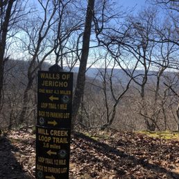
I'll preface this by saying that this is an absolutely beautiful hike, and if you know what you're getting yourself into, then have at it. My little brother (15) and I (21) went yesterday. We went in @ the TN hiking trail entrance, and saw the sign attached and thought "oh, 4.3 miles w/ a 1 mile loop back to car. That sounds like a good challenge." When we started, it was about 1:30 pm, so we figured we would have plenty of time. While the hike is beautiful, it is very, very poorly marked. We were losing our way in broad daylight because the markings are sometimes a couple hundred feet in between and the trail is very "wild." When we did get to the falls, there was no "loop trail" anywhere to be found. We made the 1.5 mile treck back to the sign saying "AL trailhead" and thinking that meant it was probably somewhat nearby, figuring we definitely could not make it back to TN before dark. What followed was 2 grueling hours in mostly complete pitch black hiking up a mountain in the woods. With the light of a phone, and running into a young couple that was as lost as we were, we finally made it back and they gave us a ride back to TN entrance. My biggest criticism would be the extreme lack of marking along the trail. This is an easy fix and wouldn't take much money to do. No feeling like not being able to find where the trail continues in pitch black without any service. Other than that, a beautiful hike.

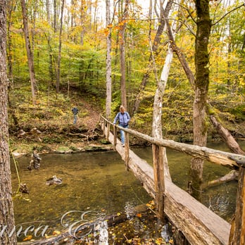
Not for the faint at heart, but worth every grueling effort in the trek back up! LOCATION Located in Estillfork in northern Alabama near the Tennessee border is what's known to be the Grand Canyon of the South. You can find Walls of Jericho about 4.5 miles north of the Town of Hytop. TRAILHEAD / PARKING LOT As of early 11/2014, WoJ has 3 entrance points - the horseback trailhead and hiking trailhead on the AL side, and another trailhead on the TN side. We entered thru the hiking trailhead in AL (it's the 2nd entrance on your left if you're going north on Hwy 79). If you pass Bear Den Point Rd on your right, then you've gone too far. Both the horseback and hiking trailhead parking lots are clearly marked w signs on Hwy 79, so keep your eyes open for these once you pass the Town of Hytop. The gravel parking lot is wide open and spacious for many vehicles. 2 porter potties available at the north end of the parking lot for those in need of these. I don't use such public amenities so I can't comment on this any further other than to say - YUCK! If you gotta go, I guess you gotta go! 8/ ABOUT Forever Wild Land Trust owns this beautiful tract of land stretching from AL and into TN. The 12,510 acres comprise of mountainous and wooded terrain, hosting caves, springs, steep rocky bluffs and portions of the headwaters of the Paintrock River. During our visit in early November, the spring beds were fairly dry on the initial portion of Turkey Creek with some wet areas due to light sprinkles the day before. We enjoyed the rocky bluffs which can be a test of your fear of heights, especially if there are a lot of fallen leaves on the trail which can be slippery. It's more of a guessing game to see whether rocks and roots hide beneath the leaves. Flexibility in your footing helps even with hiking boots on to avoid ankle injury. THE HIKE 5/5 There are two optional hikes here - out & back (confirmed 8.6 miles RT), and a semi-loop (an additional estimated 4+ miles RT). We did the out & back this time which is what I'll cover here. Descending 1000ft is a breeze, but your knees may suffer. On the flip, you can expect the ascent back to be quite a grueling experience with most aches focused in your thighs. Periodic brief breaks are helpful, along w adequate drinks and healthy snacks. Be sure to look up during your careful trek on the single-track switchbacks on the Hiker Trail. Descending steadily downward through the hickory-oak forest, you'll see towering trees (cedars, hickory, redbuds, walnut), ferns, moss-covered boulders, rocks, fallen leaves, sinkholes, spring branch crossing over Hurricane Creek, and a foot bridge w a loose handrail made of wood (warning: don't rely solely on this to keep your balance. Use it more as a guide across w your hands gliding ever so lightly on the rail side). As you reach Clark Cemetary, you'll see and continue into the gorge saddling alongside a bluff-line following Turkey Creek. We didn't see a sign, but we eventually crossed the borderline into TN. We were welcomed w a stone cathedral. We rock-hopped over the light stream onto what seemed like an island w a beautiful view of light water trickling into a deep water pool. In high season, this would be a cascade. Continuing upstream, now on the right side of Turkey Creek, we caught a glimpse of the clear and slightly deep rock bowl. Again, in high season, we would witness water spewing from a tunnel onto rocks, forming a wide fountain-like waterfall. In our visit, we saw 1/10 of it. Clambering up the dry, sheer rock stream bed, we reached an empty water-carved cavity where the stream flows underground to emerge in the aforementioned. Since it was empty, hubby and a few others climbed down into the deep cavity while I and the rest captured the beauty on lens or eyes alone. Looking up one could see the hand caves for climbing up the rock cliffs. No one in our 28-person group came prepared to rappel. With the beauty surrounding us, we rested and enjoyed lunch instead underneath the sheltering hosting cave and on the rock edge above the dry stream bed. After about an hour of feasting, good fellowship, laughter, and panoramic group photos, we made our way back through the familiar path. This time ascending slowly, thru what seemed more a narrow path on the bluff edge, avoiding the damp areas and sinkholes, too tired now to break out the camera, enduring the growing aches in our thighs that periodically prompted brief breaks by some among our group (yes, including moi). Don't let the grandeur of the mountain ahead to discourage you from trekking on. Yes, the mountain you see is what you have to climb back up. Prayer & determination kept us moving forward even thru the extremely rocky and grueling terrain. Before we knew it, we reached the trailhead. The sense of achievement overwhelmed us along w relief. VERDICT & RETURN 5/5 This is the place for a challenging adventure. Bring drinks and snacks to quench & energize you! We'll be back!

1 year ago
7 years ago
This is a strenuous hike. Even if you do a short loop at 7.5 miles, the elevation climbing back to the parking lot is killer. I enjoyed myself the way down, 5 star hike. Note you arrive at the walls and it's a pretty little pool with mini waterfalls. You need to climb up the waterfalls to see the really impressive formations. Definitely worth the effort. But, climbing back up to the parking lot: disheartening. I had a miserable time. Also to note, do not make the mistake I did of going in July in Alabama: the heat and humidity were intense. read more


On the Tennessee-Alabama border, is a Wildlife Management Area named the Bear Hollow Mountain Wildlife Management Area. Bear Hollow Mountain is over 21,000 acres. Within this area is a 750 natural area named the Walls of Jericho. It's about an hour and forty five minute drive from Nashville. The Walls itself is referred to often as "The Grand Canyon of the South," because when you hike to the Walls of Jericho, you find yourself in a 150 foot wide bowl surrounded by 200 foot tall walls. A traveling minister found it in the late 1880s and named it, and it sat on private property until recently. It was purchased by the Nature Conservancy in 2003, and then sold to Alabama's Forever Wild Program. Alabama spent $9.3million for its portion of the land, and Tennessee spend $5.9million for its portion. The waterfalls form Paint Rock River, and the walls are surrounded by forestry. The forestry itself has at least 15 federally endangered or threatened species. The Walls of Jericho opened officially August 27th, 2004. There is a horseback riding trail, and two openings to the hiking trail- one on the Tennessee side, and one on the Alabama side. Ya'll. This is a hard hike. Even though I hike sporadically, I was not prepared. We drove an hour and forty five minutes from Nashvillle, and arrived. The parking lot had portapotties. There was no cellular service. We began the hike, which is quoted in different places as 6, 7, and 8 miles. There are paper maps in a box at the head of the trail, but they aren't well done or easily readable. As you hike, the path is marked with red marks on trees. However, the hiking trail intersects with the horseback riding trail and forks off to the other states' entrance, and it isn't well marked at all. The hike down into the forest to the canyon took my party about 2 hours, and was super easy as it was literally all downhill, with spots of rugged terrain. The hike back up took us close to 4 hours, and was decidedly difficult. Now, some hikes I've done have been steadily uphill. However, hiking back from the Walls of Jericho was a steep heavy incline for a few feet, followed by a segment of flatland, and it alternated back and forth. Since you're in a valley, the sun sets very early. For us, we began the hike at noon, the sun began to set at 5:15, and we arrived back at the car at 5:45. The scenes surrounding you are beautiful. There are sparse benches, and even an old cemetery. I wish there was more to tell us about the history of the place or the family who'd previously owned it- even on the back of the takeaway maps. Bring water and a backpack of granola. I wouldn't imagine doing this in the dead of summer, so January was perfect, temperature-wise. Go challenge yourself and do this hike.. and prepare to be sore for two days afterward; it's absolutely worth it. read more


8 years ago
I'll preface this by saying that this is an absolutely beautiful hike, and if you know what you're getting yourself into, then have at it. My little brother (15) and I (21) went yesterday. We went in @ the TN hiking trail entrance, and saw the sign attached and thought "oh, 4.3 miles w/ a 1 mile loop back to car. That sounds like a good challenge." When we started, it was about 1:30 pm, so we figured we would have plenty of time. While the hike is beautiful, it is very, very poorly marked. We were losing our way in broad daylight because the markings are sometimes a couple hundred feet in between and the trail is very "wild." When we did get to the falls, there was no "loop trail" anywhere to be found. We made the 1.5 mile treck back to the sign saying "AL trailhead" and thinking that meant it was probably somewhat nearby, figuring we definitely could not make it back to TN before dark. What followed was 2 grueling hours in mostly complete pitch black hiking up a mountain in the woods. With the light of a phone, and running into a young couple that was as lost as we were, we finally made it back and they gave us a ride back to TN entrance. My biggest criticism would be the extreme lack of marking along the trail. This is an easy fix and wouldn't take much money to do. No feeling like not being able to find where the trail continues in pitch black without any service. Other than that, a beautiful hike. read more

4 years ago
Not for the faint at heart, but worth every grueling effort in the trek back up! LOCATION Located in Estillfork in northern Alabama near the Tennessee border is what's known to be the Grand Canyon of the South. You can find Walls of Jericho about 4.5 miles north of the Town of Hytop. TRAILHEAD / PARKING LOT As of early 11/2014, WoJ has 3 entrance points - the horseback trailhead and hiking trailhead on the AL side, and another trailhead on the TN side. We entered thru the hiking trailhead in AL (it's the 2nd entrance on your left if you're going north on Hwy 79). If you pass Bear Den Point Rd on your right, then you've gone too far. Both the horseback and hiking trailhead parking lots are clearly marked w signs on Hwy 79, so keep your eyes open for these once you pass the Town of Hytop. The gravel parking lot is wide open and spacious for many vehicles. 2 porter potties available at the north end of the parking lot for those in need of these. I don't use such public amenities so I can't comment on this any further other than to say - YUCK! If you gotta go, I guess you gotta go! 8/ ABOUT Forever Wild Land Trust owns this beautiful tract of land stretching from AL and into TN. The 12,510 acres comprise of mountainous and wooded terrain, hosting caves, springs, steep rocky bluffs and portions of the headwaters of the Paintrock River. During our visit in early November, the spring beds were fairly dry on the initial portion of Turkey Creek with some wet areas due to light sprinkles the day before. We enjoyed the rocky bluffs which can be a test of your fear of heights, especially if there are a lot of fallen leaves on the trail which can be slippery. It's more of a guessing game to see whether rocks and roots hide beneath the leaves. Flexibility in your footing helps even with hiking boots on to avoid ankle injury. THE HIKE 5/5 There are two optional hikes here - out & back (confirmed 8.6 miles RT), and a semi-loop (an additional estimated 4+ miles RT). We did the out & back this time which is what I'll cover here. Descending 1000ft is a breeze, but your knees may suffer. On the flip, you can expect the ascent back to be quite a grueling experience with most aches focused in your thighs. Periodic brief breaks are helpful, along w adequate drinks and healthy snacks. Be sure to look up during your careful trek on the single-track switchbacks on the Hiker Trail. Descending steadily downward through the hickory-oak forest, you'll see towering trees (cedars, hickory, redbuds, walnut), ferns, moss-covered boulders, rocks, fallen leaves, sinkholes, spring branch crossing over Hurricane Creek, and a foot bridge w a loose handrail made of wood (warning: don't rely solely on this to keep your balance. Use it more as a guide across w your hands gliding ever so lightly on the rail side). As you reach Clark Cemetary, you'll see and continue into the gorge saddling alongside a bluff-line following Turkey Creek. We didn't see a sign, but we eventually crossed the borderline into TN. We were welcomed w a stone cathedral. We rock-hopped over the light stream onto what seemed like an island w a beautiful view of light water trickling into a deep water pool. In high season, this would be a cascade. Continuing upstream, now on the right side of Turkey Creek, we caught a glimpse of the clear and slightly deep rock bowl. Again, in high season, we would witness water spewing from a tunnel onto rocks, forming a wide fountain-like waterfall. In our visit, we saw 1/10 of it. Clambering up the dry, sheer rock stream bed, we reached an empty water-carved cavity where the stream flows underground to emerge in the aforementioned. Since it was empty, hubby and a few others climbed down into the deep cavity while I and the rest captured the beauty on lens or eyes alone. Looking up one could see the hand caves for climbing up the rock cliffs. No one in our 28-person group came prepared to rappel. With the beauty surrounding us, we rested and enjoyed lunch instead underneath the sheltering hosting cave and on the rock edge above the dry stream bed. After about an hour of feasting, good fellowship, laughter, and panoramic group photos, we made our way back through the familiar path. This time ascending slowly, thru what seemed more a narrow path on the bluff edge, avoiding the damp areas and sinkholes, too tired now to break out the camera, enduring the growing aches in our thighs that periodically prompted brief breaks by some among our group (yes, including moi). Don't let the grandeur of the mountain ahead to discourage you from trekking on. Yes, the mountain you see is what you have to climb back up. Prayer & determination kept us moving forward even thru the extremely rocky and grueling terrain. Before we knew it, we reached the trailhead. The sense of achievement overwhelmed us along w relief. VERDICT & RETURN 5/5 This is the place for a challenging adventure. Bring drinks and snacks to quench & energize you! We'll be back! read more


11 years ago
My boys and I went here for a fun adventure, of hiking and camping. It's a hell of a hike. Well worth it, trail is well marked ,clean. Our camp site was perfect for us. Bailey, Liam, Kenny and eoghan. Thank you so much for coming with me. read more

More info about Walls of Jericho
Al Hwy 79
Estillfork, AL 35745
Directions
Hours
Outdoor Amenities
Ask the Community - Walls of Jericho

Why does Yelp recommend reviews?
1 review that is not currently recommended
The reviews below are not factored into the business's overall star rating.
1 year ago
Walls of Jericho - hiking - Updated July 2026
Best of Estillfork
People found Walls of Jericho by searching for…
Things to Do in Estillfork, AL
Swimming Holes in Estillfork, AL
Hiking Trails With Waterfalls in Estillfork, AL
River Swimming in Estillfork, AL
Scenic Views in Estillfork, AL
Beautiful Views in Estillfork, AL
Scenic Overlook in Estillfork, AL
Swimming Lakes in Estillfork, AL
Running Trails in Estillfork, AL
Walking Trails in Estillfork, AL
Mountain Biking in Estillfork, AL
Lookout Points in Estillfork, AL
Camping Sites in Estillfork, AL
Tent Camping in Estillfork, AL


